Subject: Polar
Period: 1795 (circa)
Publication:
Color: Hand Color
Size:
11.2 x 7.6 inches
28.4 x 19.3 cm
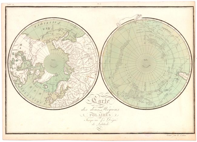
Finely engraved map with north and south polar projections. Land contours around the Arctic Circle are still very speculative and on America's Pacific Northwest coast is the apocryphal entrance to a Northwest Passage, reported by Admiral de Fonte in 1640, but disproved after later navigators such as James Cook and George Vancouver surveyed the coast in detail in the late 18th century. On the South Polar map are the tracks of Abel Tasman in 1642, and Captains Cook and Furneaux in 1769, 1773 and 1774. This map is based on Comte de Buffon's map of the same name, which was originally published in Histoire Naturelle. Jean Chevalier De Beaurain Sr. lived from 1696-1771 and was a well known Parisian cartographer, who was appointed Geographe Du Royal (Royal Geographer to the King) in 1721. After his father's death, Jean de Beaurain Jr. carried on his father's mapmaking business and is best known for his chart of Boston Harbor, Massachusetts, based on Des Barre's chart of the same region. Engraved by Etienne Collin.
References:
Condition: B+
Original color with light soiling. Trimmed close to neatline at right.