Subject: Western United States
Period: 1856 (dated)
Publication: U.S. Pacific Railroad Surveys
Color: Hand Color
Size:
23 x 12.5 inches
58.4 x 31.8 cm
During the 1850s, the U.S. government sponsored an extensive series of expeditions designed to gather information on the vast new territories that had been acquired in western North America. The discovery of gold in California further stimulated westward traffic and heightened the need for a faster and more convenient way to bring the far-flung parts of the country together. In 1853 Congress commissioned the Army's Topographic Bureau to conduct a series of surveys to find a suitable route for a transcontinental railroad. There were six major expeditions; five of them covered the area between the Great Plains and west coast, and the sixth explored the coastal states of California and Oregon. All of these expeditions were accompanied by naturalists and artists to document the landscape, flora and fauna along the route.
The reports, maps and lithographs were published in the 13 volume report "Explorations and Surveys to ascertain the most practicable and economical route for a Railroad from the Mississippi river to the Pacific Ocean."
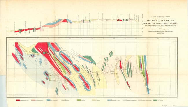
Ten different geological units are found along a stretch of land from El Paso to Maricopa Wells. The tracks of Lt. John G. Parke, of the Topographical Engineers are shown, as is the location of the beautiful Mission San Xavier del Bac near Tucson. The map is also shown as a profile in the upper margin.
References:
Condition: B+
There is a binding trim at lower left and a small extraneous crease near the lower left fold. Issued folding.