Subject: Guyana
Period: 1680 (published)
Publication:
Color: Hand Color
Size:
20.2 x 16 inches
51.3 x 40.6 cm
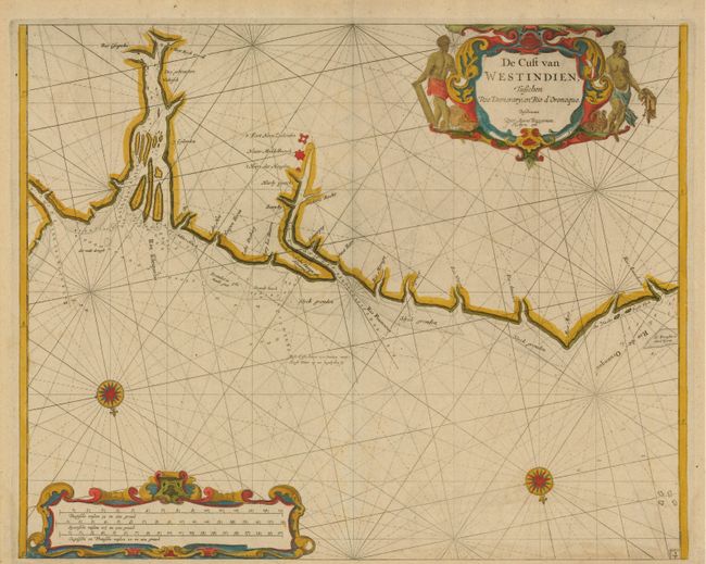
This rare map is the first Dutch sea chart devoted to Guyana. It is focused on the coastline between the Demerara and Orinoco rivers and on the settlements of New Middelburgh and Fort New Zealand on the Rio Pomeroon. The region depicted was contested between the English and Dutch during the 17th century as both colonial powers attempted to establish tobacco and sugar plantations. The Dutch settlements on the Rio Pomeroon and Fort Kyck overal (look everywhere around), at the confluence of the Cuyuni, Masaruni, and Essequebo were destroyed by the British in 1666, at about the time the map was compiled. Two fine compass roses orient the chart with north on the bottom and strapwork cartouches complete the adornment.
Arent Roggeveen, a land surveyor and mathematician, taught navigation for the Dutch East and West India Companies. He also helped maintain their collection of hydrographic manuscripts and charts. In the mid 1660s, Roggeveen compiled a series of large-scale sea charts of North America and the West Indies, which was published by Pieter Goos in Het Brandende Veen or The Burning Fen. This landmark atlas was the first Dutch pilot to focus on the Americas, with a number of regions mapped in larger scale than in any previously printed work. Roggeveen died in 1679 and Goos' widow sold the plates to Jacob Robijn, who reissued the maps with his name added to the title in 1680. Both editions are extremely rare.
References:
Condition: A
Faintly toned, else fine.