Subject: Alaska
Period: 1799 (published)
Publication: Vancouver's Voyages (French Edition)
Color: Black & White
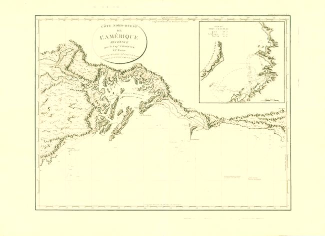
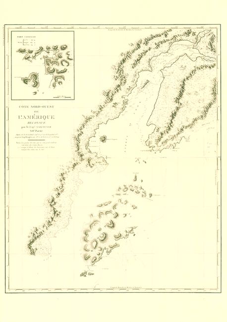
This is a matched pair of beautifully engraved, large-scale charts that together show an important region of Alaska between Mt. St. Elias, across Prince William Sound, the Kenai Peninsula, Kodiak Island, Cook Inlet and Turnagain Arm, and partially down the Alaska Peninsula to about Amber Bay. During the summers of 1792-94, George Vancouver and the crew of the British ships Discovery and Chatham mapped the northwest coast of North America from Baja California to Alaska. Vancouver's voyage was the last, and longest, of the great Pacific voyages of the late eighteenth century. A skilled and competent sailor and explorer, Vancouver eliminated the possibility of a Northwest Passage. His remarkably precise surveys completed the outline of the Pacific. Includes:
1. Cote Nord-Ouest de l'Amerique Reconnue par le Cape. Vancouver. VIe., (27.8 x 21.2"). This is the eastern-most chart in the pair featuring the coastal topography from Mt. St. Elias in the east to the eastern side of Kenai Peninsula to include the small Chiswell Islands in the Blying Sound. Includes a good representation of the interior mountainous terrain. Shows great detail of Prince William Sound with numerous fiords and islands including Montague. Inset of "Plan du Port Chalmers."
2. Cote Nord-Ouest de l'Amerique Reconnue par le Cape. Vancouver. VIIe., (24.3 x 30"). This chart begins where VI leaves off at the Chiswell Islands, continuing westward, covering the most populous areas of today's Alaska. It details the area to include the area of today's Anchorage, Eagle River, Palmer, Wasilla, all of Kenai Peninsula, Cook Inlet and its Turnagain Arm, Kodiak Island and part of the Alaska Peninsula. Mt. Redoubt is simply called "Volcan" and is depicted as a steaming mountain. Provides great detail along Cook Inlet, naming the Russian Factories on the western shore about where today's Chugiak power plant is located. The area of today's Anchorage is blank other than "Pte. Campbell" and "Pte. Voranzow." The coastline of Kodiak Island is mostly depicted except for the blank northeast portion. Large inset "Port Chatham."
References: 1) Falk (Alaska) 1799-6; 2) Falk (Alaska) 1799-7.
Condition: A+
Both are flawless examples on bright paper, strong impression and full, wide margins.