Subject: Colonial Southeast, Florida and Cuba
Period: 1591 (circa)
Publication: Grand Voyages, Part II
Color: Black & White
Size:
17.9 x 14.4 inches
45.5 x 36.6 cm
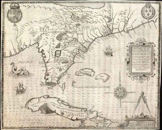
This is one of the most influential maps of colonial North America. De Bry purchased Jacques le Moyne's map from his widow to illustrate the early French colonial attempts in the region. Le Moyne accompanied the second expedition to Florida in 1564 where he recorded and mapped the region. The small settlement and Fort Carolina on St. John's River (called River May by the French) was destroyed by the Spanish and Le Moyne narrowly escaped. He made his way to London where he settled. Despite the fact that his map is not very accurate it was extremely influential; partially because Hondius copied it and included it in his editions of the Mercator Atlas, which had wide circulation and popularity. The map's inaccuracy is mainly in the longitude, which resulted in an extended eastward slant to the Atlantic coastline. Most of the information presented was derived from Indian sources including several spurious lakes. Many of these features were copied by subsequent cartographers for over 150 years. The large body of water at top is variously thought to be a representation of the Sea of Verrazzano (thought at the time to connect to the Pacific and provide a route to Asia) or the Great Lakes. The waterfall nearby is thought to be derived from Indian tales of Niagara Falls. The map is richly adorned with a superb compass rose, two fine cartouches, sailing ships, a fanciful sea monster, and the royal arms of Spain's Phillip II and France's Charles IX.
References: Burden #79; Cumming #14; Garratt (TMC) #G2; Pritchard & Taliaferro #3.
Condition: B+
Issued folded, now flattened, with expert repairs at the bottom and sides of the map including some paper restoration and a few tiny lines of skilled facsimile in the latitude markings at right. The margins are very narrow as is usually with this map. There is some minor toning.