Subject: Europe & England
Period: 1745 (circa)
Publication: Rapin's History of England
Color: Black & White
Size:
18 x 14 inches
45.7 x 35.6 cm
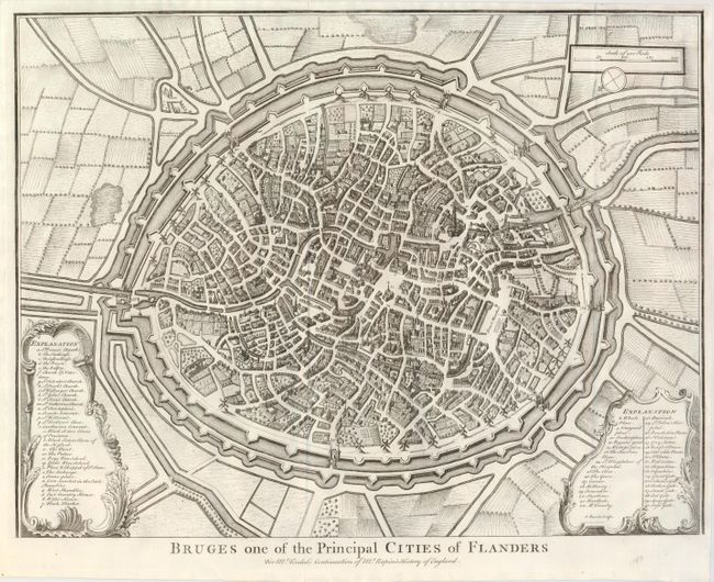
1) Bruges one of the Principal Cities of Flanders. This beautifully engraved chart is a detailed bird's-eye view of the fortified town contained within concentric rings of walls and ramparts separated by a moat. There is remarkable detail within the town with every street and building individual shown. Two decorative cartouches make up the legend that lists over 60 places of importance including the Flesh-Market; Whale Place; St. John's Hospital; the Barefoot Friars, numerous churches and more.
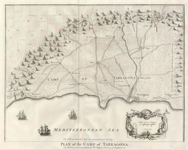
2) Plan of the Camp of Tarragona. Shows the road to Barcelona, the road to Tortosa, and the towns of Valls, Constantina, Villa Secca, Cambrils, la Silva and several more. Crosses are used to indicate hills that are "impracticable for Cavalry" travel. The ancient town of Tarragona is shown with its large fortifications. Decorated with a nautical-themed cartouche and three finely engraved sailing ships under sail.
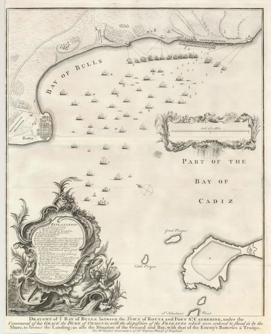
3) Draught of ye Bay of Bulls between the Town of Rotta and Fort St. Catherine… This highly decorative chart shows over 40 ships in the harbor including a line of 15 three-masters along the shore firing on the town and fort. The chart is embellished with a large legend cartouche and a smaller one containing the scale of miles.
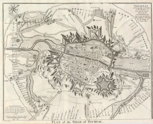
4) Plan of the Siege of Tournay. Tournay A Strong City and Castle in the Earldom of Flanders, taken by the Confederates July 7, 1709 and left as a Barrier Town to the Dutch by the Treaty of Utrecht. Major buildings are located and named within the city which is surrounded by a wide and complex system of fortifications, including the extensive Citadel. The town is surrounded by scores of opposing forces, each named: Saxon Guards, Temple, Meridith, Regiment of Saxon Dragoons, and Reysing Dragoons.
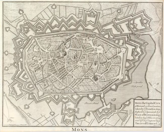
5) Mons the Capital City of Hainault in ye Low Countries, taken by ye French in 1691, Restor'd to ye Spaniards by ye Peace of Ryswick in 1697, retaken by ye Allies in 1709, and left to ye Emperor by ye Treaty of Utrecht. This is a spectacular bird's-eye view of the fortified town with its vast ramparts and lakes. Remarkable detail within the town with every street and building individual shown.
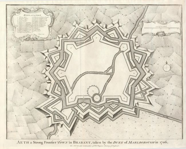
6) Aeth a Strong Frontier Town in Brabant, taken by the Duke of Marlborough in 1706. This is a plan of the extensively fortified town with 23 places named in the highly decorative legend.
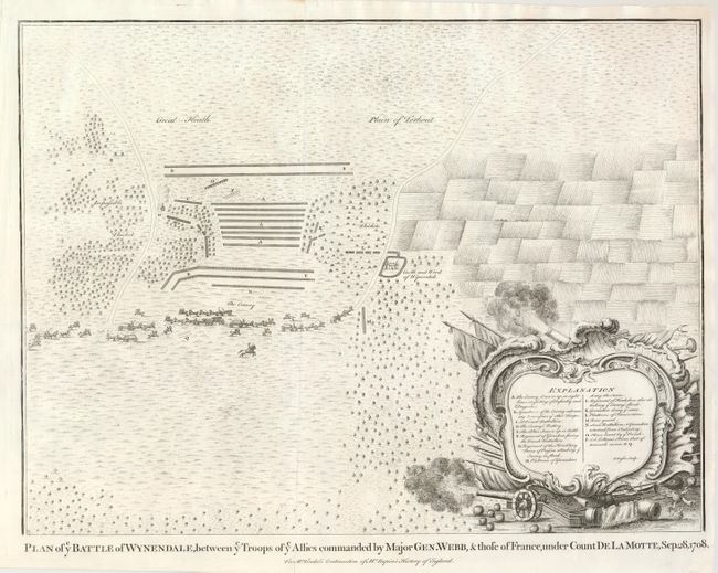
7) Plan of ye Battle of Wynendale, between ye Troops of ye Allies commanded by Major Gen. Webb, & those of France, under Count de la Motte, Sep. 28, 1708. Troops are mounted. The castle is shown within its moat. Beautiful military-themed cartouche.
References:
Condition: A
Clean examples with dark, strong impressions.