Subject: Wyoming, Yellowstone Park
Period: 1900-08 (dated)
Publication:
Color: Printed Color
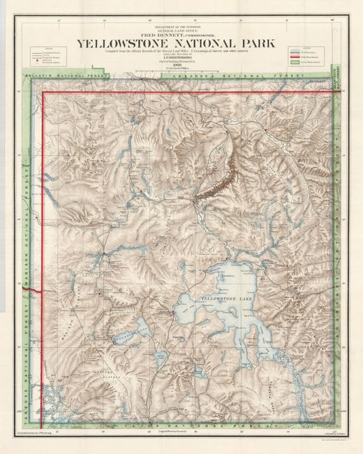
1) The title of this large 1908 map continues, "Compiled from the Official Records of the General Land Office, U.S. Geological Survey and other sources under the direction of I.P. Berthrong Chief of Drafting Division." A beautifully colored and finely engraved map that is filled with many details, showing all rivers and streams, waterfalls, lakes, roads, and trails. The legend further locates Snowshoe Cabins, Stations, and differentiates between trails and roads. It locates all of the geyser basins and names scores of individual geysers. The recently constructed Old Faithful Lodge is on the map simply as "Hotel." This famous landmark was constructed in three phases between 1903 and 1927. At this stage, only the original section (known today as the Old House) was completed. The effect of stone lithography is evident in the depiction of contour with stipple-style shading. This very handsome map of the park was completed during Fred Dennett's term as Commissioner to the General Land Office. Compiled and drawn by I.P. Berthrong and lettered by C.J. Helm. (20 x 25.3")
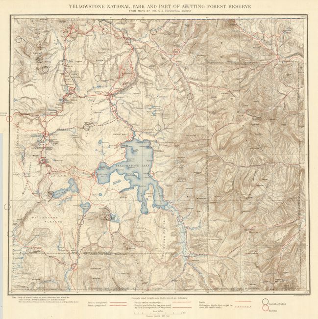
2) The title continues, "From Maps by the U.S. Geological Survey.", Julius Bien & Co. Lith. N.Y., no date but circa 1900. This beautifully colored topographical map was issued by the Park Superintendent after maps by the U.S. Geological Survey. It shows the entire park in great detail at a scale of four miles per inch. The legend identifies ranger stations, snowshoe cabins, existing roads, unused roads, trails and more. It locates the remote Shoshone, Lewis and Heart Lakes; names the Upper, Shoshone, Gibbon, and Heart Lake Geyser Basins, Mud Geysers, Mammoth Hot Springs, and much more. There is terrific detail of topography with contour intervals at 100 feet, watershed and numerous features. (19 x 18")
References:
Condition: A+
Both folding as issued. The latter has a very short, closed tear in margin at binding trim.