Subject: Northwestern United States
Period: 1860 (published)
Publication: U.S. Pacific Railroad Surveys
Color: Black & White
Size:
60.5 x 23.5 inches
153.7 x 59.7 cm
During the 1850s, the U.S. government sponsored an extensive series of expeditions designed to gather information on the vast new territories that had been acquired in western North America. The discovery of gold in California further stimulated westward traffic and heightened the need for a faster and more convenient way to bring the far-flung parts of the country together. In 1853 Congress commissioned the Army's Topographic Bureau to conduct a series of surveys to find a suitable route for a transcontinental railroad. There were six major expeditions; five of them covered the area between the Great Plains and west coast, and the sixth explored the coastal states of California and Oregon. All of these expeditions were accompanied by naturalists and artists to document the landscape, flora and fauna along the route.
The reports, maps and lithographs were published in the 13 volume report "Explorations and Surveys to ascertain the most practicable and economical route for a Railroad from the Mississippi river to the Pacific Ocean."
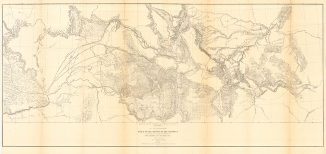
This remarkable map details the 1853-1855 surveys conducted to locate a northern route (47th and 49th Parallels) on an expedition led by Isaac Stevens, Governor of Washington Territory. Most of the map covers Montana, with extraordinary detail and excellent relief by hachure, rivers and streams, numerous routes with dates, and interesting topographical commentary. The map not only shows the main party's route, but also numerous routes followed by the various parties attached to the command.
References: Wheat (TMW) #867
Condition: B
Issued folding, now pressed and backed with archival tissue. Hint of toning along some folds with a few small areas of loss at one fold intersection near border at upper right.