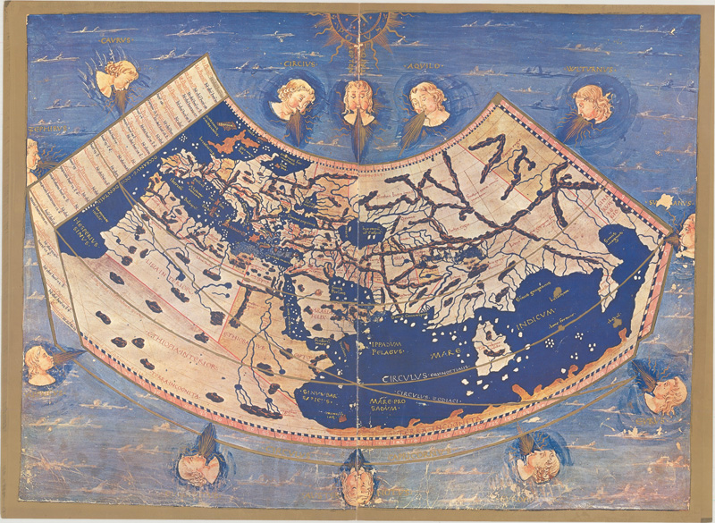
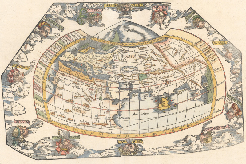
A reproduction of a Ptolemaic world map from a 1460 manuscript in the National Library of Naples. (Image courtesy of Old World Auctions - click on image to view zoomable image.)
The Maps & Edtions of Ptolemy
by Joe McAlhany
The maps are striking, odd, and far from primitive yet certainly not even remotely modern. The places are recognizable, more or less, although distorted or jagged around the borders. The place names are literally ancient, the topographical detail often little more than rudimentary rivers and ranges of rope-like mountains. Sometimes they are trapezoidal in shape, while the world maps are often projected in the shape of a stretched accordion. The world they show rarely covers even the entire Eastern Hemisphere, and when they do extend into the world beyond that limited scope, the details are sketchy, incomplete, and shockingly new.
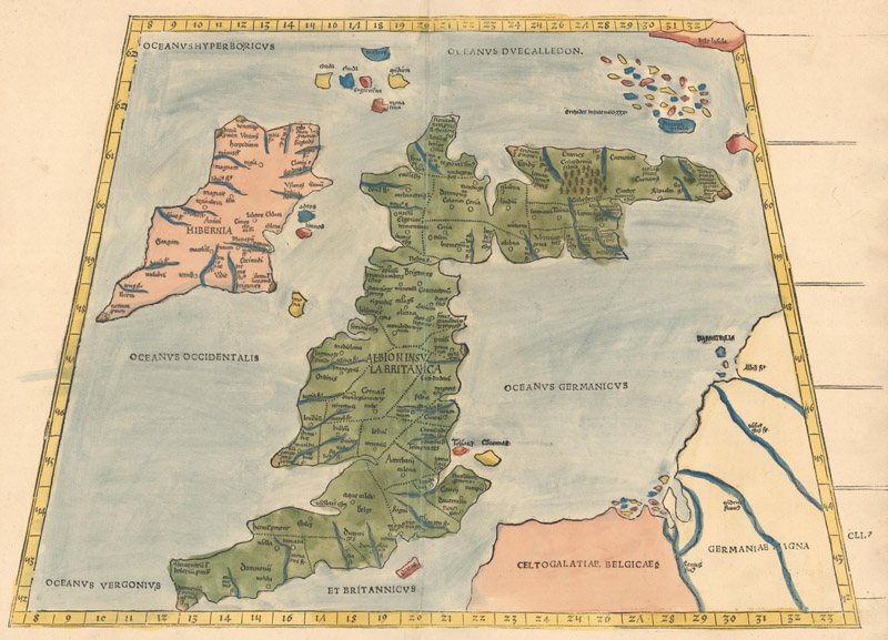
The Ptolemy/Waldseemüller map of the British Isles (1520). (Image courtesy of Old World Auctions - click on image to view zoomable image.)
The maps from the cycle of Ptolemaic works published between 1477 to 1730 are undoubtedly unusual. Based on the work of the 2nd-century geographer Claudius Ptolemy, they provide a glimpse into an ancient understanding of the world, albeit one filtered through the publishers, editors, and engravers of the Renaissance era. Published in dozens of editions over the course of 250 years, with multiple variations, revisions, and additional maps, Ptolemy’s Geographia can be hard to categorize and comprehend. These editions do not limit themselves to Ptolemy’s knowledge of the world; as information flooded in about the New World, publishers were quick to add maps to reflect the latest cartographic developments. Part of the fun in tracking the various editions of the Geographia is witnessing the progression from the Ancient World into a new era of geographical sophistication and discovery. It is our hope that the following primer will provide some clarity about Ptolemy, his ideas, and the most notable editions of his Geographia (including the most important of the modern maps therein).
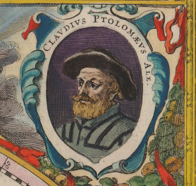
Portrait of Ptolemy from Henricus Hondius’s Nova Totius Terrarum Orbis Geographica ac Hydrographica Tabula (1630). (Image courtesy of Old World Auctions - click on image to view zoomable image.)
So who was Ptolemy? There is very little solid biographical information about Claudius Ptolemaeus the man. What we know about him is his work: he was an astronomer, a mathematician, and, most importantly for our purposes here, a geographer. Besides his intellectual pursuits and achievements, it is known that he lived for approximately 70 years during the second century; most biographies estimate that he was born circa 100 AD and died circa 170 AD. It is believed that he was Greco-Egyptian and a Roman citizen. He certainly spent several very productive years in or around the Egyptian city of Alexandria, then under Roman control. At the time, Alexandria was the world’s wealthiest city, an intellectual and commercial hub with its famous library and merchants and travelers passing through from all corners of the ancient world. There was no better place on the planet for a geographer to do his work.
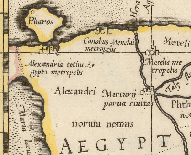
Ptolemy’s home base of Alexandria, from Mercator’s Ptolemaic map of Egypt, Appendix Tab. III. Africae, Aegyptum Inferiorem Exhibens... (ca. 1730). (Image courtesy of Old World Auctions - click on image to view zoomable image.)
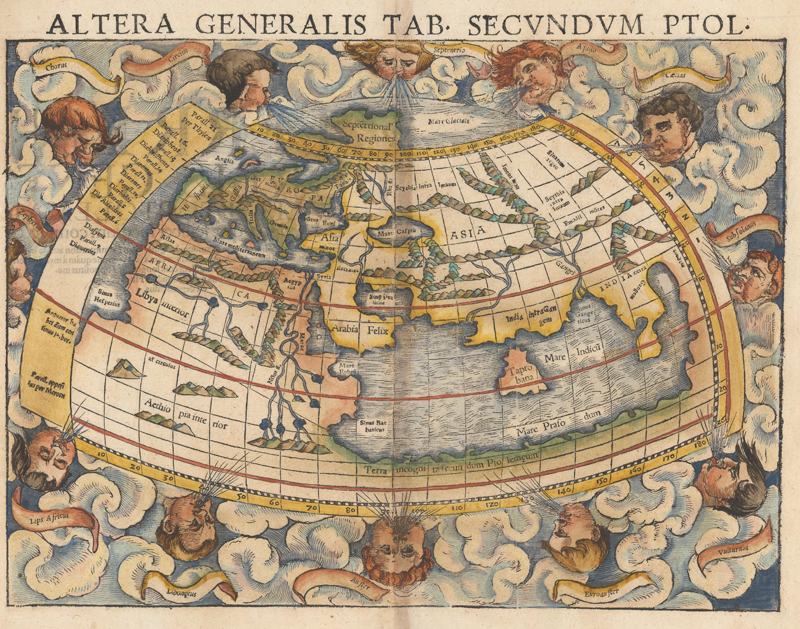
Ptolemy’s reputation as a geographer rests on his geographical treatise Geōgraphikḕ Hyphḗgēsis (“Geographical Guide”), or the Geographia (the Latin title for which it is commonly known). Composed around 150 AD, the Geographia defines geography as “a representation in picture of the whole known world together with the phenomena which are contained therein.” It is the earliest surviving cartographic collection, described by Adolf Erik Nordenskiöld, the Fenno-Swedish Arctic explorer and father of the modern historical study of cartography, as “the prototype of almost all geographical atlases.” Much of the work is a response to, and revision of, the work of Roman-Syrian geographer Marinus of Tyre (ca. 70 – ca. 130 AD), now lost except for Ptolemy’s commentaries on it. Divided into 8 books and featuring 27 maps, the Geographia describes the extent of the known world from the mythical Fortunate Islands east to Magnus Sinus (the ancient conflation of the Gulf of Thailand and South China Sea), and from Thule (a mysterious island in northern Europe, possibly Shetland, Orkney, or part of Norway) south to the alleged twin sources of the Nile in the Mountains of the Moon.
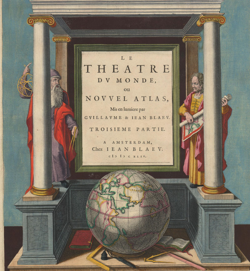
The Blaeu family pays respect to their geographic forefathers Ptolemy (left) and Marinus (right) on an atlas title page. (Image courtesy of Old World Auctions - click on image to view zoomable image.)
The great innovation of the Geographia is Ptolemy’s insistence on an orderly, systematic presentation of the world, with detailed instructions on how to source data and draw maps. It is the earliest extant text to record latitudes and longitudes, with Ptolemy providing the coordinates for approximately 8,000 locations across the ancient world. He also wrote extensively about map projections, critiquing the distorted technique apparently utilized by Marinus, in which the parallels and meridians were straight lines, intersecting at right angles. Ptolemy also outlined two projections for drawing maps on a planar surface. The first was a conical projection, with curved latitudes and straight longitudes converging at a point north of the pole at Thule. In the second, more complicated projection, both the latitudes and longitudes are curved, therefore better approximating the spherical nature of the globe. However, with the exception of his world map, which was delineated on a conical projection, Ptolemy plotted the original 26 regional maps according to Marinus’s flawed projection.
The world on a modified conical projection from a Fries edition of 1541. (Image courtesy of Old World Auctions - click on image to view zoomable image.)
It is unknown whether or not Ptolemy himself made maps to accompany his geographical writings; certainly there are no surviving maps by his hand, or, for that matter, any remaining copies of his work that date back to antiquity. Manuscripts of the Geographia do credit the cartographer Agathodaemon of Alexandria, likely a contemporary of Ptolemy, with devising a map of the known world using the eight books of the Geographia as his guide. But the earliest known copy of the Geographia with maps is a Greek manuscript from the 13th century. Still, because of Ptolemy’s detailed text and instructions, future mapmakers had a template to create their own Ptolemaic maps.
Although it is in the classic Ptolemaic format, this map of China, Korea, and Japan from the Fries edition of 1541 is an excellent example of a map that extends beyond the bounds of Ptolemy’s geographical knowledge. (Image courtesy of Old World Auctions - click on image to view zoomable image.)
For much of the Middle Ages, as the Greek language fell out of vogue with scholars, Ptolemy’s work as a geographer was largely forgotten in the western world. Muslim cartographers of the 10th and 11th centuries were familiar with Ptolemy, but their surviving maps reflect their own traditions and show little of the Greco-Egyptian geographer’s direct influence. If not for a Latin translation by Italian humanist Jacopo d’Angelo (Jacobus Angelus), the Geographia might have disappeared into total obscurity like the volumes of Marinus. Completed in Florence in 1406, d’Angelo’s translation ignited new interest in Ptolemy’s geographical concepts as several elaborate manuscript copies proliferated throughout Europe. The most important of these manuscript editions were compiled by the Benedictine scholar Donnus Nicolaus Germanus (ca. 1420 – 1490). Starting in the 1460s, Germanus produced at least a dozen manuscript copies of the Geographia, with illuminated maps based on Ptolemy, albeit in an improved trapezoidal projection. Germanus’s renditions of Ptolemy’s maps would prove hugely influential, serving as the model for nearly all the printed copies of the Geographia published in the latter 15th century. He also extended the purview of Ptolemy’s world, adding new regional maps in the Ptolemaic mold that were not outlined in the original work.
Ruscelli’s La Geografia di Claudio Tolomeo Alessandrino... (Image courtesy of Old World Auctions - click on image to view zoomable image.)
After the advent of the printing press, numerous printed editions of the Geographia were published beginning in the late 15th century, with a galvanic impact on Renaissance cartographers and geographers. In his Facsimile-Atlas (1889), Nordenskiöld identified 56 editions, from the first Bologna edition (which Nordenskiöld lists with an estimated publication date of 1472 but later scholars corrected it to 1477) to Carl Müller’s “new, critical, Greek-Latin edition” of 1883. Henry N. Stevens lists 60 in his monograph Ptolemy’s Geography: A Brief Account of All the Printed Editions Down to 1730 (1908). Carl Moreland and David Bannister include 42 editions published between 1477 and 1730 in a useful appendix to their map collecting primer Antique Maps (1983). Since these lists were compiled, there has been at least one new translation of Ptolemy’s Geographia by J. Lennary Berggren and Alexander Jones, published by Princeton University Press in 2002. Our intention here is not to reconcile and collate the extant bibliographies or provide a comprehensive survey of each edition, but instead to present a crash course in the key publishers, editors, engravers, and editions, focusing on the distinguishing characteristics and milestones of interest to collectors.
1477 Dominicus de Lapis
Naturally we must begin with the first printed edition of Ptolemy’s work with maps, the Bologna edition printed by Dominicus de Lapis in a run of 500 copies in 1477. The colophon refers to the work as “Cosmographia” and inaccurately notes the publication date as 1462. According to the catalogers of Nordenskiöld’s collection, this is a poorly edited volume, with shoddy engraving work on its 26 maps. However, quality aside, the volume is considered the first atlas of engraved maps.
1478 Arnold Buckinck
Before the publication date of the above edition was conclusively agreed upon, the Rome edition printed by Arnold Buckinck in 1478 was often cited as the first edition. The engraving of this edition was supervised by Buckinck and Konrad Sweynheim, an apprentice of Johannes Gutenberg who introduced the printing press to Italy and developed the method of “punched letter” printing. Sweynheim’s work was extremely important in the evolution of the printed map. Indeed, Nordenskiöld has high praise for the engraving in this edition: “The maps of this edition were, as masterpieces of copper-plate printing, not surpassed for centuries, and they will still take the first place among the maps of all the numerous editions of Ptolemy's geography hitherto published.” The same plates appeared in subsequent editions in 1490, 1507, and 1508, with minor adjustments to the old plates and seven new plates in the latter two. The 1508 edition is notable for the addition of a supplement on the New World by Marcus Beneventanus and an extraordinary new world map by Johannes Ruysch, Universalior Cogniti Orbis Tabula Ex Recentibus Confecta Obsevationibus, the first obtainable printed map to show part of the Americas (a portion of South America and some Caribbean islands).
Map of France from the Rome edition of 1478. (Image courtesy of Old World Auctions - click on image to view zoomable image.)
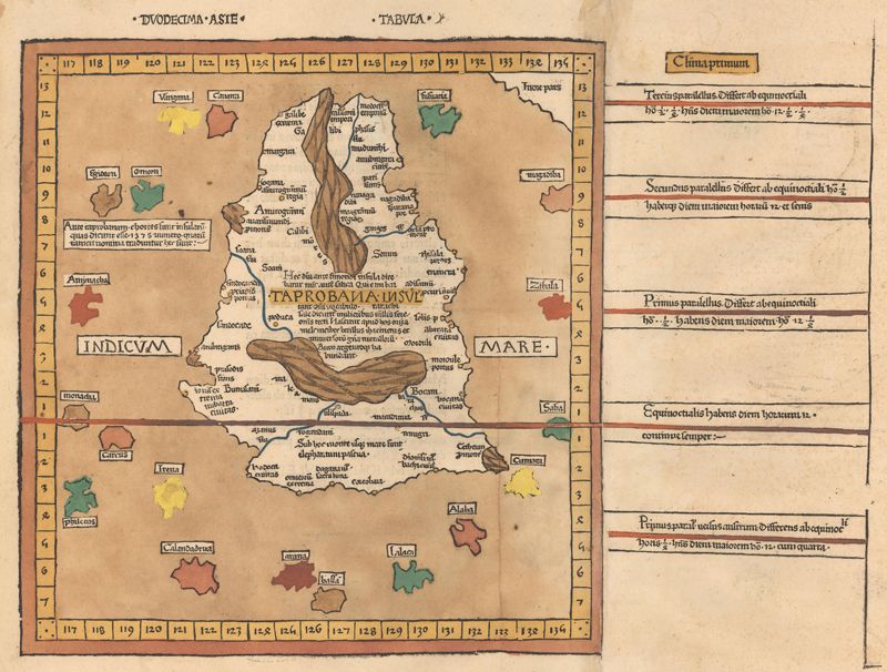
1482 Francesco Berlinghieri
Francesco Berlinghieri paraphrased Ptolemy in Italian terza rima (a poetic form) for his Florence edition, published circa 1482, making it the first atlas published in vernacular Italian. It is also the first atlas to include printed modern maps, with four new maps drawn from contemporary sources: Novella Italia, Hispania Novella, Gallia Novella, and Palestina Moderna et Terra Sancta. In addition to these monumental firsts, the maps of Berlinghieri’s edition are the only ones to adhere to the original projection derived from Marinus, with equidistant meridians and parallels instead of curved ones.
Tabula Nona d Asia, an example of the rectilinear projection used in the Berlinghieri edition. (Image courtesy of Old World Auctions - click on image to view zoomable image.)
1482 Nicolaus Germanus/Lienhart Holle
The Ulm edition of 1482, printed by Lienhart Holle, was the first edition to be printed outside of Italy and the first edition of Ptolemy to include woodcut maps. It also features the first instance of a map crediting an engraver (Johannes Schnitzer, on the world map) and the first printed map to cover Scandinavia, Iceland, and Greenland. Edited by Nicolaus Germanus himself, it was based on his third revised manuscript edition and opens with the Benedictine musing on his improved projection. This edition was copied and reprinted by Johann Reger in 1486, with the addition of an alphabetical listing of various places not identified by Ptolemy and a tacked-on treatise on locales of interest, based on dated medieval sources.
The map of Taprobana (Sri Lanka) from the 1486 Ulm edition. (Image courtesy of Old World Auctions - click on image to view zoomable image.)
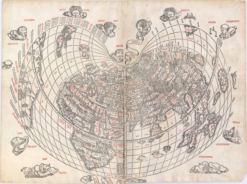
1511 Bernardus Sylvanus
In 1511, Bernardus Sylvanus edited the text and maps for the first Venice edition of Ptolemy. Printed by Jacobus Pentius de Leucho, it was the first atlas to use two-color woodblock printing. The maps were first printed in black, with place names and headings printed in red ink by means of type set into the woodblock and applied with a second strike of the plate. Little is known of Sylvanus, a native of Southern Italy, although he is believed to have been a monk. Realizing that Ptolemy's maps were outdated, Sylvanus set out to update them with modern information, often from current manuscript sources. His methodology in updating Ptolemy was somewhat random and haphazard, but the resulting hybrid of classical and modern information was an important leap in 16th-century mapmaking, an attempt to push beyond reverence for Ptolemy to a more contemporary cartography. His edition included revised versions of the original 27 Ptolemaic maps and a new "modern" world map, depicted for the first time in a distinctive cordiform (heart-shaped) projection, which was adopted by several later cartographers and used for a number of important 16th-century maps.
Sylvanus’s Ptolemaic and modern cordiform world maps. (Image courtesy of Old World Auctions - click on image to view zoomable image.)
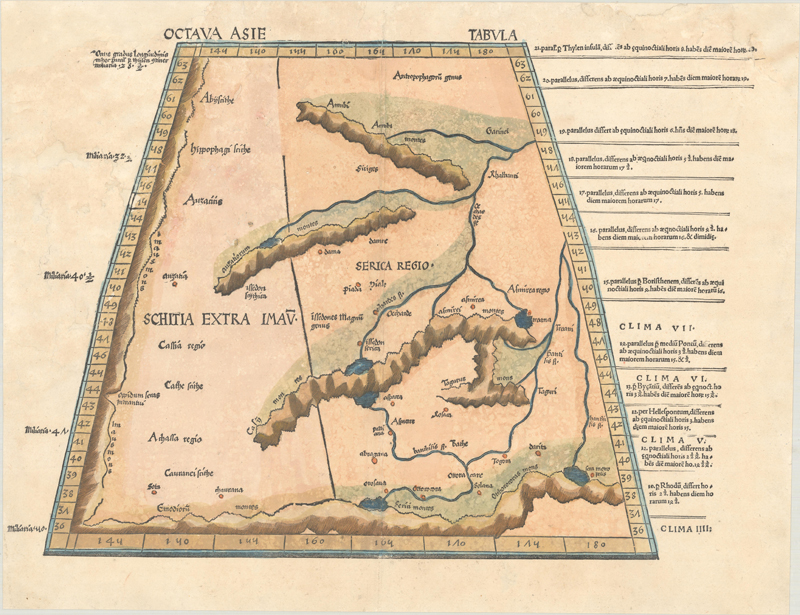
1513 Martin Waldseemüller
“Perhaps the most important of all the editions,” writes Henry N. Stevens, is the 1513 Strasbourg edition printed by Johannes Schott. Of its 47 maps, 20 are modern maps created by the German cartographer Martin Waldseemüller, who plotted out the new edition with his partner Matthias Ringmann. (The edition was brought to completion by, and credited to, Jacobus Eszler and Georgius Ubelin.) These new maps comprise what is widely considered the first modern atlas. New maps had previously been added to past editions of the Geographia, of course, but they had never been clearly distinguished from the ancient maps alongside them. Waldseemüller wanted a clear split between the ancient and modern; here, the tabulae novae are in a separate appendix, divided from the Ptolemaic originals by a title page and colophon. The key maps in this edition are two of the newer maps: Orbis Typus Universalis Iuxta Hydrographorum Traditionem, the modern world map, and Tabula Terrae Novae, also known as the “Admiral’s Map” (the “Admiral” in question being Christopher Columbus), the first map devoted to the Americas to appear in an atlas.
Waldseemüller’s Octava Asie Tabula (1520). (Image courtesy of Old World Auctions - click on image to view zoomable image.)
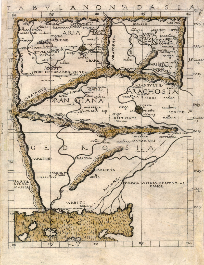
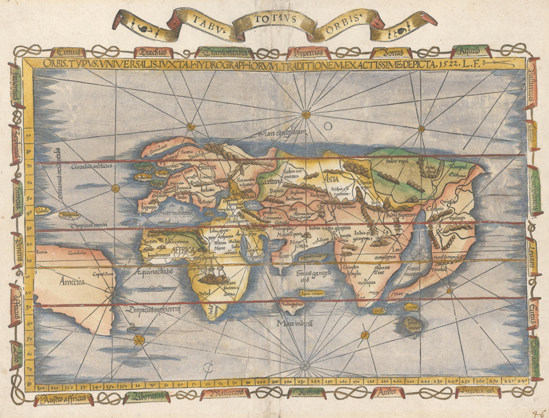
1522 Laurent Fries
In 1522, the physician and mathematician Laurent Fries edited a new edition of the Geographia, printed by Johannes Grüninger in Strasbourg. It featured reduced copies of both the ancient and modern maps from the 1513 edition, as well as 3 new maps. The last of the maps is Orbis Typus Universalis Iuxta Hydrographorum Traditionem Exactissime Depicta, an original world map by Fries. Nordenskiöld is quite scathing in his assessment of this map, a warped depiction of the world that bungles even well-known areas of the Old World. But it is desirable among collectors today as the first map in a Ptolemaic atlas to use the name “America,” which is emblazoned across South America. The blocks from the Fries edition were used again in 1525, and then in posthumous editions in 1535 and 1541. The 1535 edition, printed by Melchior and Gaspar Treschel, was edited by Michael Villanovus (known as Servetus). This edition is less noteworthy for its maps than for its backstory. Servetus was charged with heresy by John Calvin in 1553, in part due to his irreverent editorial notes in the margins of the Geographia. The courts found him guilty and he was burnt at the stake, atop a pyre of his own books, including his Geographia.
Fries’s modern world map, with the first appearance of “America” on a map in an edition of Ptolemy. (Image courtesy of Old World Auctions - click on image to view zoomable image.)
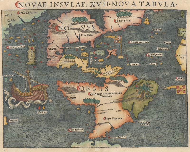
1540 Sebastian Münster
Before he published his magnum opus the Cosmographia in 1544, the Basel-based geographer Sebastian Münster released his edition of the Geographia. Printed by his stepson Heinrich Petri in 1540, Münster’s take on Ptolemy included 48 maps: 27 classic Ptolemaic maps and an additional 21 modern maps, among them the first set of continental maps. Novae Insulae, XVII Nova Tabula, his important map of the Western Hemisphere, popularized the name of America as it was reprinted in the many subsequent issues of the Geographia and Cosmographia. Many of Münster’s new woodcut maps played fast and loose with Ptolemy’s geographical rules and standards; for instance, his maps of the continents completely lacked longitude and latitude. But his maps were attuned to new discoveries and marked another step forward in the evolution of Ptolemaic maps into the modern age.
Old and new worlds from Munster’s Geographia. (Image courtesy of Old World Auctions - click on image to view zoomable image.)
1548 Giacomo Gastaldi
Münster’s Geographia was a slightly smaller edition of Ptolemy, which was reduced even further by Giovanni Baptista Pedrezano’s Venice edition of 1548, the earliest pocket atlas. (The editions edited by Giovanni Antonio Magini and engraved by Girolamo Porro, beginning with the 1596 edition published in Venice, are another great example of small-format Ptolemaic maps.) An Italian translation of the Münster edition, it included 60 maps engraved in fine detail on copper plates by the great Giacomo Gastaldi. From this point on, copper plates overtook wood blocks as the preferred medium of engravers; Münster’s edition of 1552 is the last Ptolemaic atlas with woodcut maps. Less than half of the maps in this volume are Ptolemaic in origin, and the book features a series of groundbreaking regional maps of the New World, including the first map of the east coast of the present-day United States and Canada, a map of New Spain, and maps of Cuba and Hispaniola. According to Philip Burden, “This edition of Ptolemy’s Geography was the most comprehensive atlas produced between Martin Waldseemuller’s Geographiae of 1513, and the Abraham Ortelius Theatrum of 1570.”
Gastaldi’s Ptolemaic map of Greece, with nice decorative touches, published in 1548. (Image courtesy of Old World Auctions - click on image to view zoomable image.)
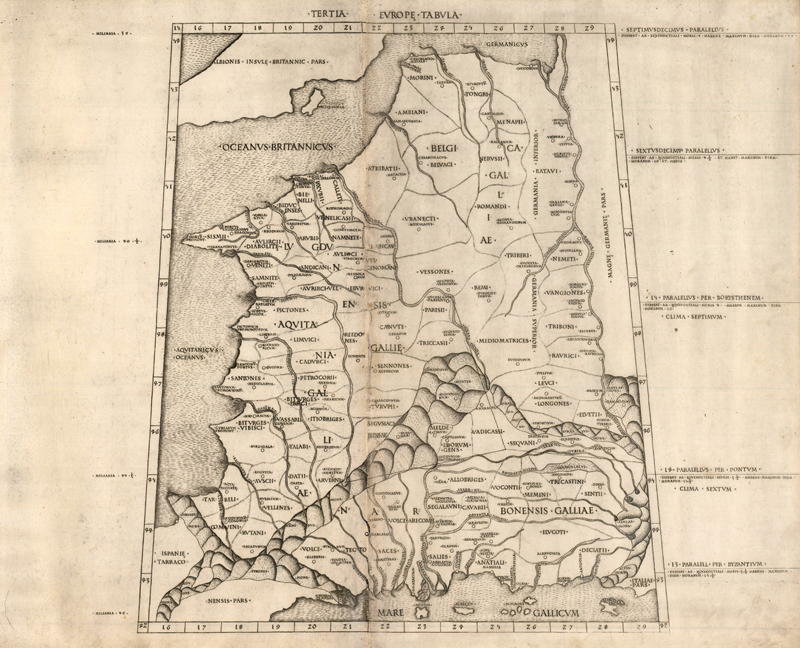
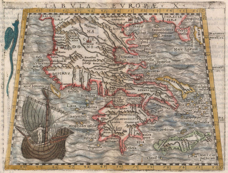
1561 Girolamo Ruscelli
Among the most popular and readily available Ptolemaic maps for the modern collector are the ones found in the editions edited by Girolamo Ruscelli. Most of the plates in Ruscelli’s edition are larger copies of Gastaldi’s work. These maps were first published in 1561 and appeared in further Italian editions in 1564, 1574, and 1598; they also appeared in Latin editions published by Giuseppe Moleto in 1562 and 1564. (Maps from the 1561-64 editions can be identified by the platemarks extending to the very top edge of the sheet.) There are 27 old maps and 37 new ones, including the first double-hemisphere world map to be published in an atlas and a copy of the infamous “Zeno map,” a map of the North Atlantic with several cartographic myths. (Click here to read more on how Ruscelli’s publication of the Zeno map legitimized and popularized its myths.)
Ruscelli’s Europae Tabula V (1561). (Image courtesy of Old World Auctions - click on image to view zoomable image.)
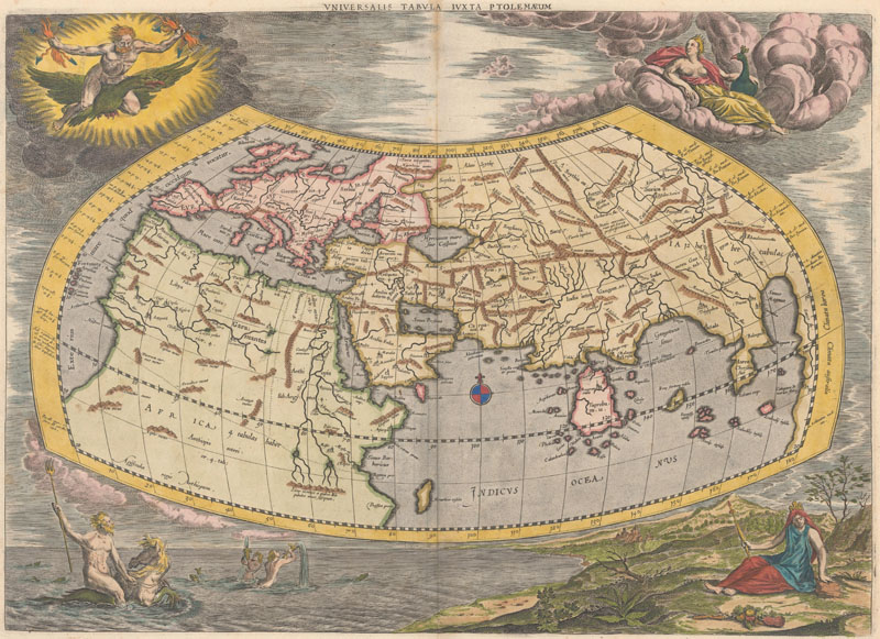
1578 Gerard Mercator
The last of the great publishers of the Geographia is Gerard Mercator, once dubbed the Ptolemy of his era by Abraham Ortelius. Although Mercator is most known today for the projection he popularized and for being the first to use the term “atlas” for a collection of maps, he devoted much of his life to his Ptolemaic maps. Instead of relying on Germanus’s revisions like most of his predecessors, Mercator returned to Ptolemy’s original types. He brought out his first edition of the Geographia in 1578, with the 27 classic Ptolemaic maps and one new one. There was no translation of Ptolemy’s text in this first edition, just justifications for Mercator’s alterations from the original coordinates; however, a translation of the Geographia by Willibald Pirckheimer appeared in the second edition of 1584. Mercator’s double-folio maps are perhaps the most distinctive, beautiful, and sophisticated of all the Ptolemaic maps, with an unmatched clarity and elegance to the engraving style and perfectly judged decorative elements, including fine, ornate cartouches. There was no topping Mercator’s edition – or perhaps cartography had finally graduated into its next phase, beyond the parameters set by a geographer from the second century. Either way, the cycle of Ptolemaic atlases concluded in 1730, with the final posthumous issue of Mercator’s Geographia.
Mercator’s stunning Ptolemaic world map, with depictions of the Four Elements in the corners (ca. 1695). (Image courtesy of Old World Auctions - click on image to view zoomable image.)
The rediscovery of Ptolemy in the 15th century, on the eve of Christopher Columbus’ epoch-shifting journey to the New World, kicked off a geographic revival in Europe. Printed collections of maps were made available to the public for the first time – it didn’t matter that they were based on ideas and information that were centuries old. European cartographers had a template, both ancient and novel, to grasp and represent the known world, via a coordinate system of latitudes and longitudes. But as the boundaries of the known world kept expanding, and the tools and methods of surveying advanced exponentially, geographic knowledge finally began to outpace Ptolemy. The shift is clear in the Ptolemaic atlases, as the tabulae modernae gradually overtook the originals in number. When Abraham Ortelius published the first modern atlas, Theatrum Orbis Terrarum, in 1570, all the maps were contemporary; even his take on the Ancient World is situated in the context of the larger world. By the end of the 16th century, the era of Ptolemaic maps was nearly over, but even today his ideas live on at the core of our understanding of geography. The Ptolemaic maps are thrilling remnants, a bridge between the roots of western geographical thought and the golden age of cartography to come.
REFERENCES
Burden, Philip D., The Mapping of North America – A List of Printed Maps 1511 – 1670, Raleigh Publications, Rickmansworth, 1996.
Mickwitz, Ann-Mari, Miekkavaara, Leena, & Rantanen, Tuula, The A.E. Nordenskiöld Collection in the Helsinki University Library – Annotated Catalogue of Maps Made Up to 1800 Vol. 2 Atlases K-Z, Helsinki University Library, Helsinki, 1981.
Nordenskiöld, A.E., Facsimile-Atlas to the Early History of Cartography with Reproductions of the Most Important Maps Printed in the XV and XVI Centuries, translated by Johan Adolf Ekelöf & Clements R. Markham, Dover Publications, Inc., New York, 1973.
Steven, Henry N., Ptolemy’s Geography: A Brief Account of All the Printed Editions Down to 1730, Theatrum Orbis Terrarum Ltd., Amsterdam, 1973.