Filtered by Category:United States(Show All Categories)
Showing results for:Auction 165
Catalog Archive
240 lots
Page 1 of 5
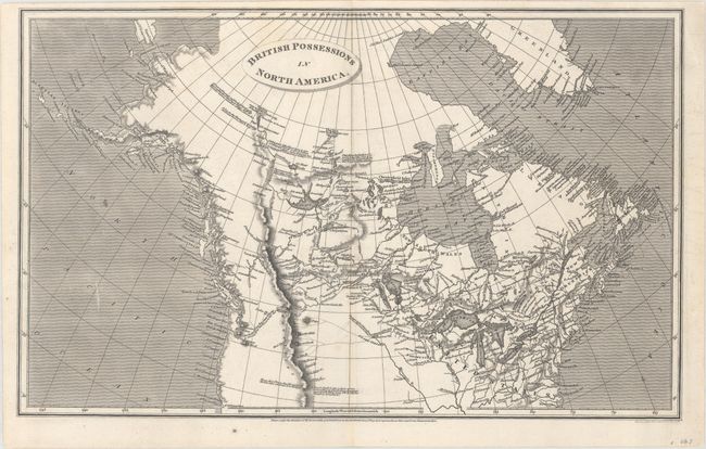
Auction 165, Lot 82
Subject: Northern United States & Canada
Arrowsmith, Aaron, Sr.
British Possessions in North America, 1809
Size: 15.7 x 9.8 inches (39.9 x 24.9 cm)
Estimate: $180 - $220
Sold for: $130
Closed on 11/15/2017
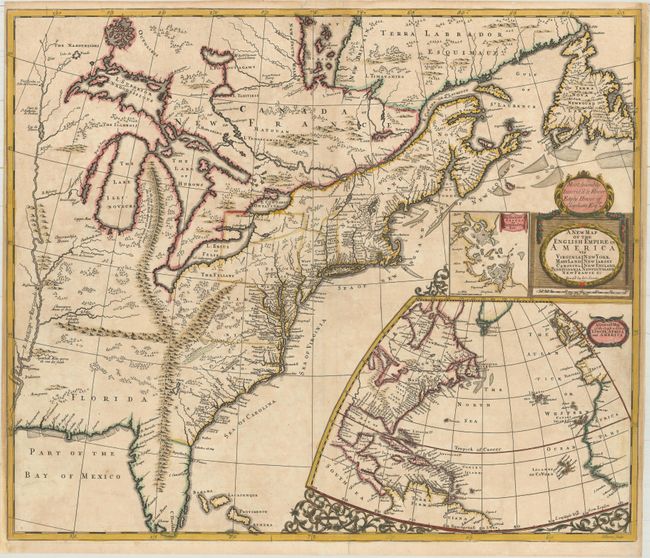
Auction 165, Lot 83
Subject: Colonial Eastern United States & Canada
Senex, John
A New Map of the English Empire in America viz Virginia New York Maryland New Iarsey Carolina New England Pennsylvania Newfoundland New France &c, 1719
Size: 23.6 x 19.9 inches (59.9 x 50.5 cm)
Estimate: $2,400 - $3,000
Important Map of the American Colonies
Unsold
Closed on 11/15/2017
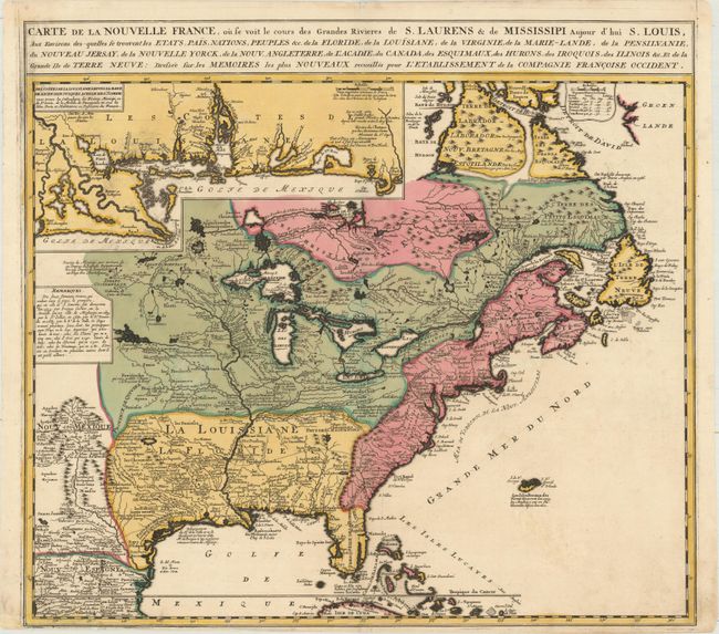
Auction 165, Lot 84
Subject: Colonial Eastern United States & Canada
Ottens/De Fer
Carte de la Nouvelle France, ou se voit le Cours des Grandes Rivieres de S. Laurens & de Mississipi Aujour d'hui S. Louis, aux Environs des Quelles se Trouvent les Etats, Pais, Nations, Peuples &c..., 1745
Size: 21.7 x 19.6 inches (55.1 x 49.8 cm)
Estimate: $2,000 - $2,300
Reduced Version of De Fer's Influential Map of French Possessions in North America
Sold for: $1,400
Closed on 11/15/2017
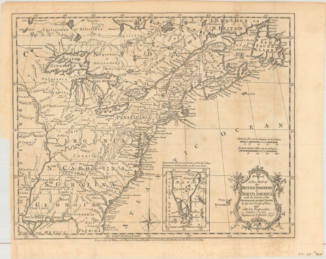
Auction 165, Lot 85
Subject: Colonial Eastern United States & Canada
Kitchin, Thomas
A New Map of the British Dominions in North America; with the Limits of the Governments Annexed Thereto by the Late Treaty of Peace, and Settled by Proclamation, October 7th 1763, 1763
Size: 11.9 x 9.6 inches (30.2 x 24.4 cm)
Estimate: $350 - $425
Sold for: $200
Closed on 11/15/2017
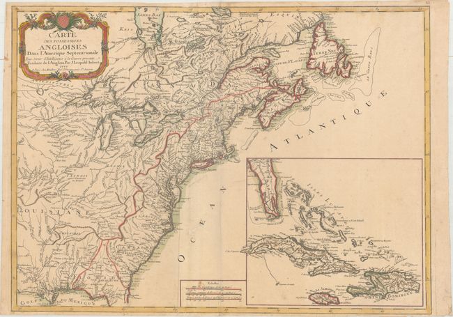
Auction 165, Lot 86
Subject: Colonial Eastern United States & Canada
Imbert, J. Leopold
Carte des Possessions Angloises dans l'Amerique Septentrionale pour Servir d'Intelligence a la Guerre Presente Traduite de l Angloise, 1777
Size: 28.9 x 21.3 inches (73.4 x 54.1 cm)
Estimate: $1,800 - $2,200
First Edition of Important Revolutionary War Map
Sold for: $1,100
Closed on 11/15/2017
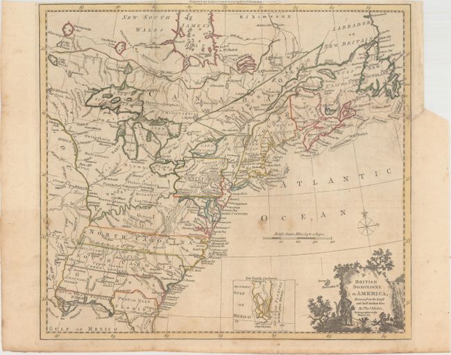
Auction 165, Lot 87
Subject: Colonial Eastern United States & Canada
Kitchin, Thomas
British Dominions in America, Drawn from the Latest and Best Authorities [with related text], 1782
Size: 14.8 x 13.4 inches (37.6 x 34 cm)
Estimate: $600 - $750
Unsold
Closed on 11/15/2017
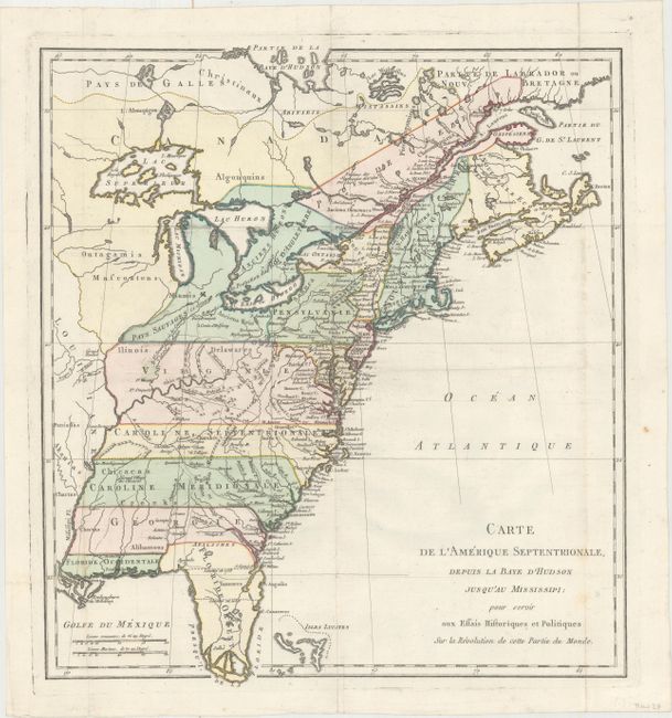
Auction 165, Lot 88
Subject: Colonial Eastern United States & Canada
Carte de l'Amerique Septentrionale, Depuis la Baye d'Hudson Jusqu'au Mississipi: pour Servir aux Essais Historiques et Politiques..., 1782
Size: 14.9 x 16.4 inches (37.8 x 41.7 cm)
Estimate: $400 - $500
Sold for: $300
Closed on 11/15/2017
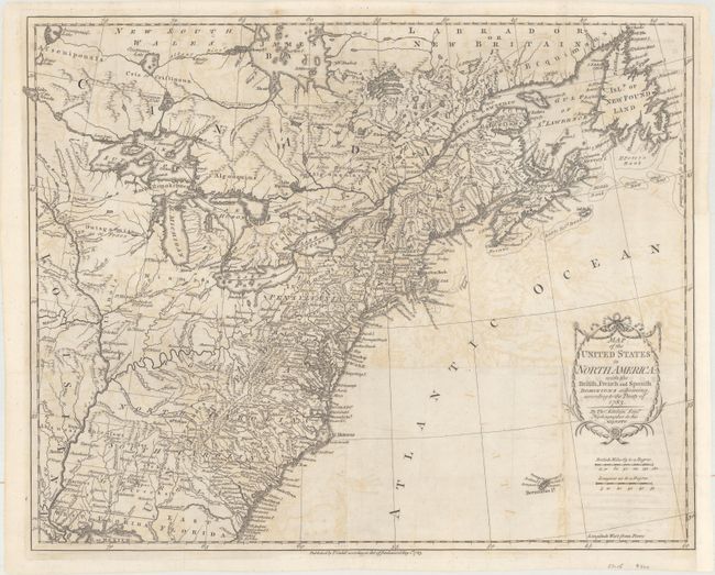
Auction 165, Lot 89
Subject: Eastern United States & Canada
Kitchin, Thomas
Map of the United States in North America: with the British, French and Spanish Dominions Adjoining, According to the Treaty of 1783, 1783
Size: 20.1 x 16.2 inches (51.1 x 41.1 cm)
Estimate: $1,000 - $1,300
One of the Earliest English-Produced Maps to Acknowledge the United States
Sold for: $550
Closed on 11/15/2017
Auction 165, Lot 90
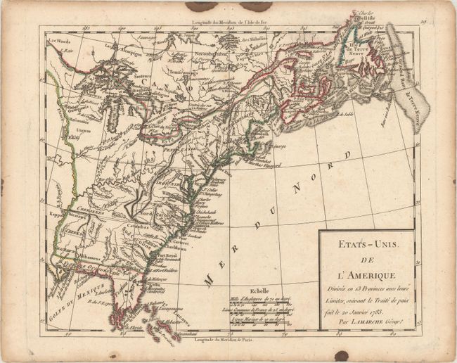
Subject: Eastern United States & Canada
Delamarche, Charles Francois
Etats-Unis de l'Amerique Divises en 13 Provinces avec leurs Limites, Suivant le Traite de Paix Fait le 20 Janvier 1783, 1790
Size: 9.3 x 8.1 inches (23.6 x 20.6 cm)
Estimate: $160 - $190
Sold for: $90
Closed on 11/15/2017
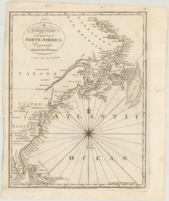
Auction 165, Lot 91
Subject: Eastern United States & Canada
Malham, John (Rev.)
A Correct Chart of the East Coast of North America, 1796
Size: 7.1 x 9.1 inches (18 x 23.1 cm)
Estimate: $120 - $150
Sold for: $90
Closed on 11/15/2017
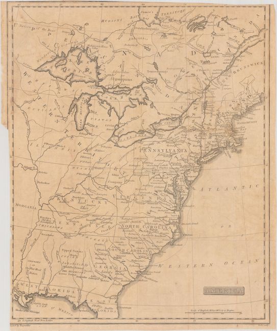
Auction 165, Lot 92
Subject: Eastern United States & Canada, Franklinia
America, 1805
Size: 12.9 x 15.9 inches (32.8 x 40.4 cm)
Estimate: $500 - $650
Unique Map Depicting Both Franklinia and Morgania
Sold for: $850
Closed on 11/15/2017
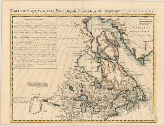
Auction 165, Lot 93
Subject: Colonial Northeastern United States & Canada
Chatelain, Henry Abraham
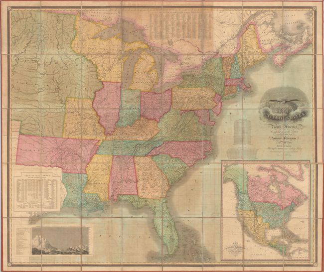
Carte du Canada ou de la Nouvelle France, & des Decouvertes qui y ont ete Faites, Dressee sur les Observations les Plus Nouvelles, & sur Divers Memoires tant Manuscrits qu' Imprimez, 1719
Size: 20.4 x 15.9 inches (51.8 x 40.4 cm)
Estimate: $600 - $750
Sold for: $400
Closed on 11/15/2017
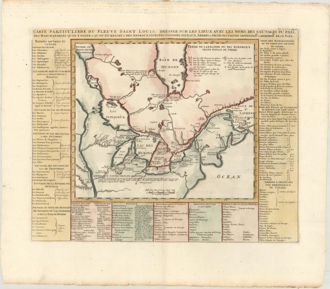
Auction 165, Lot 94
Subject: Colonial Northeastern United States & Canada, Great Lakes
Chatelain, Henry Abraham
Carte Particuliere du Fleuve Saint Louis. Dressee sur les Lieux avec les Noms des Sauvages du Pais..., 1720
Size: 18 x 14.4 inches (45.7 x 36.6 cm)
Estimate: $600 - $750
Sold for: $500
Closed on 11/15/2017
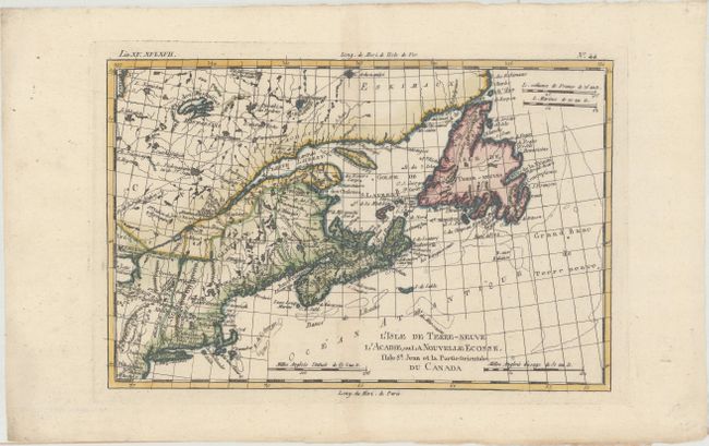
Auction 165, Lot 95
Subject: Northeastern United States & Canada
Bonne, Rigobert
L'Isle de Terre-Neuve l'Acadie, ou la Nouvelle Ecosse, l'Isle St. Jean et la Partie Orientale du Canada, 1783
Size: 12.4 x 8.2 inches (31.5 x 20.8 cm)
Estimate: $200 - $230
Unsold
Closed on 11/15/2017
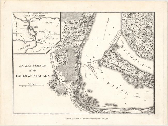
Auction 165, Lot 96
Subject: New York, Canada, Niagara Falls
[Lot of 5 - Niagara Falls], 1798-1928
Size: See Description
Estimate: $300 - $375
Sold for: $200
Closed on 11/15/2017
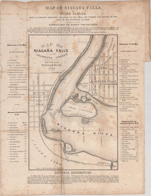
Auction 165, Lot 97
Subject: New York, Canada
The Travellers' Own Book, to Saratoga Springs, Niagara Falls and Canada, Containing Routes, Distances, Conveyances, Expenses, Use of Mineral Waters, Baths, Description of Scenery, Etc..., 1842
Size: 4.1 x 6 inches (10.4 x 15.2 cm)
Estimate: $140 - $170
Sold for: $100
Closed on 11/15/2017
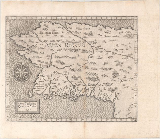
Auction 165, Lot 98
Subject: Alaska & Western Canada
Wytfliet, Cornelis
Limes Occidentis Quivira et Anian, 1597
Size: 11.4 x 9.1 inches (29 x 23.1 cm)
Estimate: $1,800 - $2,100
Early and Imaginary Map of Alaska and the Northwest Passage
Sold for: $1,300
Closed on 11/15/2017
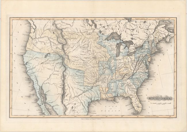
Auction 165, Lot 99
Subject: United States
Lucas, Fielding
United States, 1823
Size: 19.1 x 11.6 inches (48.5 x 29.5 cm)
Estimate: $800 - $1,000
Sold for: $650
Closed on 11/15/2017
Auction 165, Lot 100
Subject: United States, Texas, Deseret
[Lot of 3] United States [and] United States of America [and] Vereinigte Staaten von Nord-America und Mexico, 1836-50
Size: See Description
Estimate: $250 - $325
Sold for: $180
Closed on 11/15/2017
Auction 165, Lot 101
Subject: United States
[Lot of 2] Stati Uniti dell' America Settentrionale [and] United States North America, 1854-58
Size: See Description
Estimate: $200 - $240
Sold for: $150
Closed on 11/15/2017
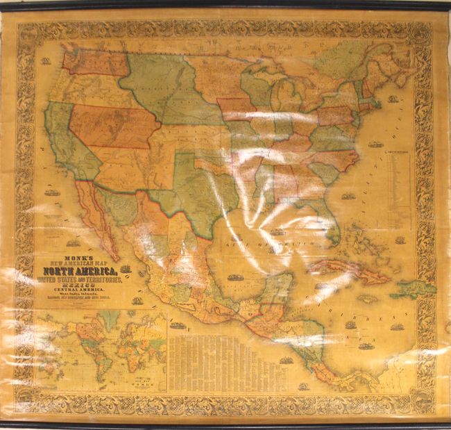
Auction 165, Lot 102
Subject: United States
Monk, Jacob
Monk's New American Map, Exhibiting the Larger Portion of North America, 1856
Size: 61 x 57 inches (154.9 x 144.8 cm)
Estimate: $1,000 - $1,300
Attractive Wall Map Featuring the Gold Region of California
Sold for: $1,100
Closed on 11/15/2017
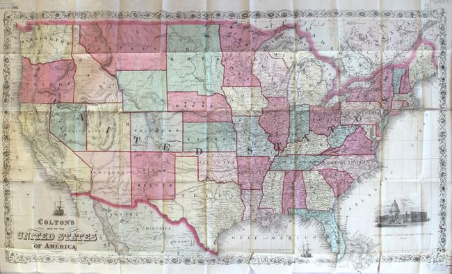
Auction 165, Lot 103
Subject: United States
Colton, G.W. & C.B.
Colton's Map of the United States of America, 1866
Size: 33.8 x 19.1 inches (85.9 x 48.5 cm)
Estimate: $800 - $950
Scarce Issue - Only 2 Sales Records Located in the Last 30 Years
Sold for: $600
Closed on 11/15/2017
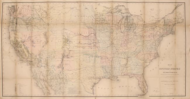
Auction 165, Lot 104
Subject: United States
General Land Office
[Map in Book] Map of the United States and Territories, Showing the Extent of Public Surveys and Other Details... [in] Report of the Commissioner of General Land Office, for the Year 1867, 1867
Size: 55.2 x 28.6 inches (140.2 x 72.6 cm)
Estimate: $325 - $400
Sold for: $240
Closed on 11/15/2017
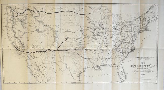
Auction 165, Lot 105
Subject: United States
Gorlinski, Joseph
The Great Railroad Routes to the Pacific, and Their Connections [in] The Policy of Extending Government Aid to Additional Railroads to the Pacific..., 1869
Size: 27.6 x 14 inches (70.1 x 35.6 cm)
Estimate: $275 - $350
Sold for: $180
Closed on 11/15/2017
Auction 165, Lot 106
Subject: United States
Petermann, Augustus Herman
[On 6 Sheets] Die Vereinigte Staaten von Nord-Amerika in 6 Blattern, 1873
Size: 16 x 13.2 inches (40.6 x 33.5 cm)
Estimate: $200 - $240
Sold for: $150
Closed on 11/15/2017
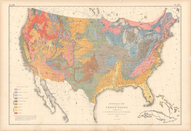
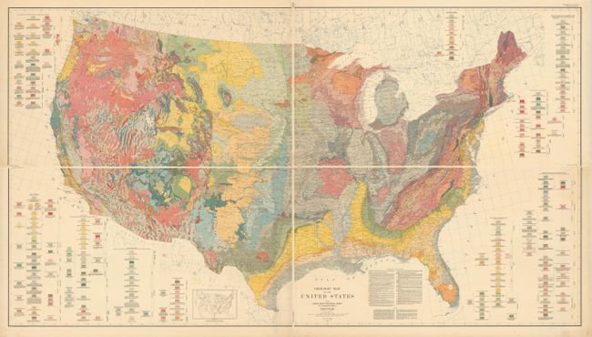
Auction 165, Lot 107
Subject: United States
Hitchcock, Charles Henry
Geological Map of the United States Compiled by C.H. Hitchcock and W. P. Blake from Sources Mentioned in the Text, 1874
Size: 28.4 x 19.7 inches (72.1 x 50 cm)
Estimate: $160 - $200
Sold for: $120
Closed on 11/15/2017
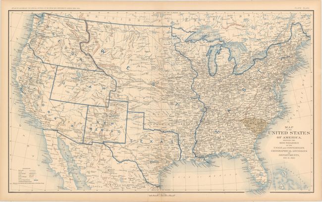
Auction 165, Lot 108
Subject: United States, Civil War
U.S. War Department
[Lot of 10] Map of the United States of America, Showing the Boundaries of the Union and Confederate Geographical Divisions and Departments Plates CLXII - CLXXI, 1891-95
Size: 27.8 x 16.9 inches (70.6 x 42.9 cm)
Estimate: $800 - $1,000
An Attractive Set Showing the Progression of the Civil War
Sold for: $600
Closed on 11/15/2017
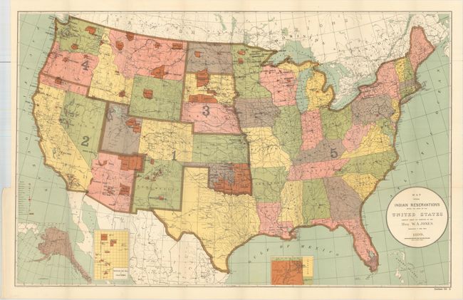
Auction 165, Lot 109
Subject: United States
U.S. Bureau of Indian Affairs
Map Showing Indian Reservations Within the Limits of the United States..., 1899
Size: 33.2 x 21.1 inches (84.3 x 53.6 cm)
Estimate: $140 - $170
Sold for: $325
Closed on 11/15/2017
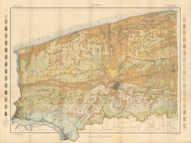
Auction 165, Lot 110
Subject: United States
U.S.D.A.
[Lot of 35 - U.S.D.A. Soil Maps], 1906
Size: 6 x 9.5 inches (15.2 x 24.1 cm)
Estimate: $200 - $250
Features Maps of Niagara Falls and Oklahoma City
Unsold
Closed on 11/15/2017
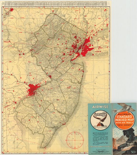
Auction 165, Lot 111
Subject: United States
Rand McNally & Co.
[Lot of 47] [46 Rand McNally Standard Indexed Map with Air Trails] [and] Advance Copy Air Trails Map of Illinois, 1929-30
Size: 25.6 x 35.2 inches (65 x 89.4 cm)
Estimate: $1,000 - $1,300
Rare Rand McNally "Air Trails" Pocket Maps
Sold for: $1,200
Closed on 11/15/2017
Auction 165, Lot 112
Subject: United States
U.S. Geological Survey (USGS)
[On 4 Sheets] Geologic Map of the United States, 1932
Size: 45.1 x 24.6 inches (114.6 x 62.5 cm)
Estimate: $200 - $300
Sold for: $600
Closed on 11/15/2017
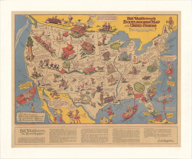
Auction 165, Lot 113
Subject: United States
Bill Whiffletree's Bootleggers' Map of the United States, 1944
Size: 30.2 x 24.1 inches (76.7 x 61.2 cm)
Estimate: $1,600 - $2,000
McCandlish's Humorous Prohibition Map
Unsold
Closed on 11/15/2017
Auction 165, Lot 114
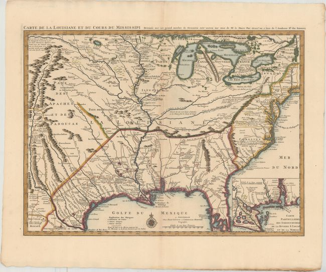
Subject: Colonial Eastern United States, Louisiana Territory
Delisle/Covens & Mortier
Carte de la Louisiane et du Cours du Mississipi Dressee sur un Grand Nombre de Memoires Entr'autres sur ceux de Mr. le Maire, 1730
Size: 23.7 x 17.3 inches (60.2 x 43.9 cm)
Estimate: $2,200 - $2,500
Delisle's Influential Map of the Louisiana Territory
Unsold
Closed on 11/15/2017
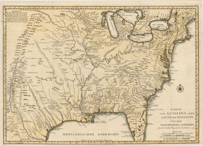
Auction 165, Lot 115
Subject: Colonial Eastern United States
Bellin, Jacques Nicolas
Karte von Luisiana, dem Laufe des Mississipi und den Benachbarten Laendern, 1744
Size: 22 x 15.5 inches (55.9 x 39.4 cm)
Estimate: $800 - $950
Scarce German Issue of Bellin's Louisiana Map
Sold for: $400
Closed on 11/15/2017
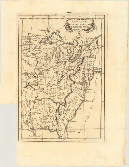
Auction 165, Lot 116
Subject: Eastern United States
Anon.
Carta della Florida, Luigiana e Laghi del Canada, 1787
Size: 6.8 x 9.9 inches (17.3 x 25.1 cm)
Estimate: $230 - $275
Unsold
Closed on 11/15/2017
Auction 165, Lot 117
Subject: Eastern United States
[Lot of 2] The United States of America, Drawn from the Latest Authorities [and] States of America, from the Best Authorities, 1790-95
Size: See Description
Estimate: $250 - $325
Sold for: $180
Closed on 11/15/2017
Auction 165, Lot 118
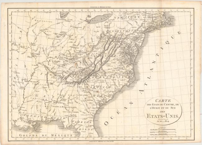
Subject: Eastern United States
Michaux, Francois A.
Carte des Etats du Centre, de l'Ouest et du Sud des Etats-Unis, 1804
Size: 19.8 x 14.2 inches (50.3 x 36.1 cm)
Estimate: $325 - $400
Sold for: $190
Closed on 11/15/2017
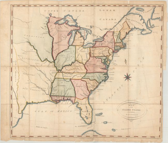
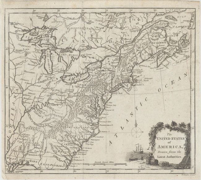
Auction 165, Lot 119
Subject: Eastern United States
Map of the United States Including Louisiana, 1810
Size: 18.4 x 16.3 inches (46.7 x 41.4 cm)
Estimate: $500 - $650
Features a Few Unusual Cartographic Anomalies
Sold for: $375
Closed on 11/15/2017
Auction 165, Lot 120
Subject: Eastern United States
United States of America, 1812
Size: 9.3 x 7.5 inches (23.6 x 19.1 cm)
Estimate: $110 - $140
Sold for: $75
Closed on 11/15/2017
Auction 165, Lot 121
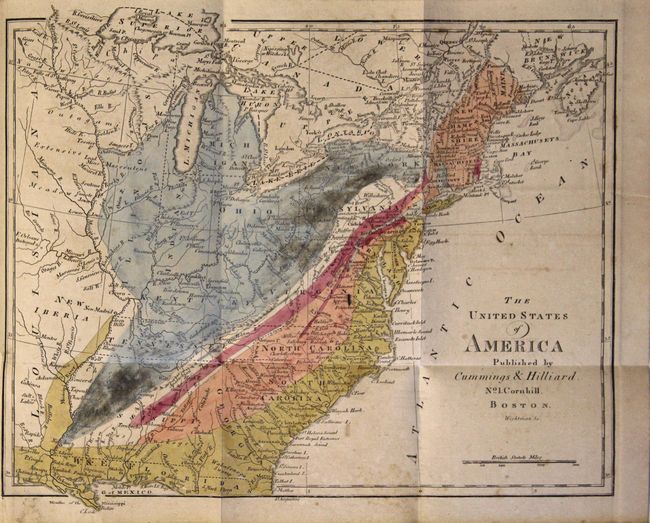
Subject: Eastern United States
Cummings & Hilliard
The United States of America [bound in] An Elementary Treatise on Mineralogy and Geology, Being an Introduction to the Study of These Sciences..., 1816
Size: 10.9 x 9 inches (27.7 x 22.9 cm)
Estimate: $550 - $700
Sold for: $400
Closed on 11/15/2017
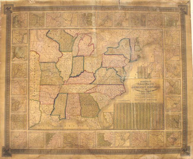
Auction 165, Lot 122
Subject: Eastern United States
Vance, David H.
Map of the United States of North America Compiled from the Latest and Most Authentic Information, 1825
Size: 61.6 x 51.8 inches (156.5 x 131.6 cm)
Estimate: $6,000 - $7,500
First Edition of Vance's Scarce, Large Map of the United States
Sold for: $3,500
Closed on 11/15/2017
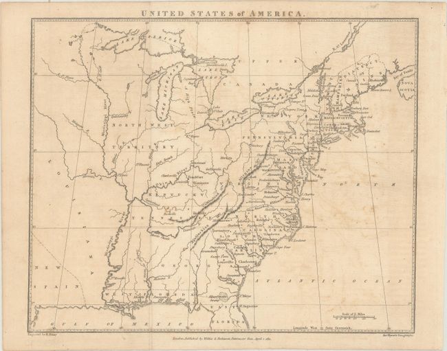
Auction 165, Lot 123
Subject: Eastern United States
Mitchell, Samuel Augustus
Mitchell's Travellers Guide Through the United States. A Map of the Roads, Distances, Steam Boat & Canal Routes &c., 1834
Size: 21.8 x 17.3 inches (55.4 x 43.9 cm)
Estimate: $650 - $800
Sold for: $450
Closed on 11/15/2017
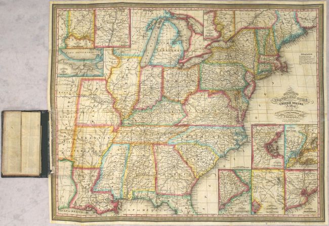
Auction 165, Lot 124
Subject: Eastern United States
Mitchell/Young
Mitchell's National Map of the American Republic or United States of North America. Together with Maps of the Vicinities of Thirty-Two of the Principal Cities and Towns in the Union, 1843
Size: 46.6 x 38.3 inches (118.4 x 97.3 cm)
Estimate: $950 - $1,200
Unsold
Closed on 11/15/2017
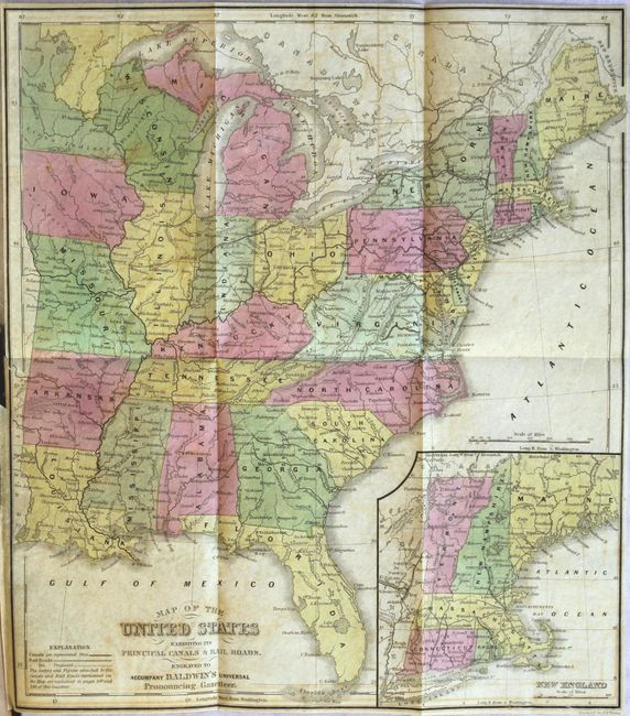
Auction 165, Lot 125
Subject: Eastern United States
Young, James H.
Map of the United States Exhibiting Its Principal Canals & Rail Roads [in] A Universal Pronouncing Gazetteer..., 1846
Size: 11.5 x 12.9 inches (29.2 x 32.8 cm)
Estimate: $160 - $190
Unsold
Closed on 11/15/2017
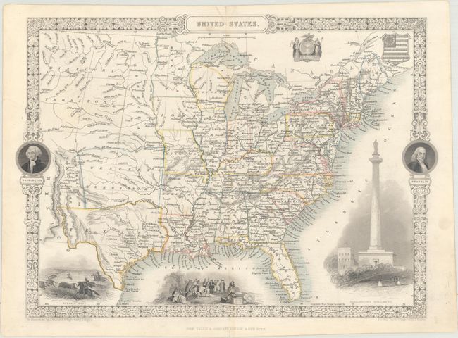
Auction 165, Lot 126
Subject: Eastern United States
Tallis, John
United States, 1851
Size: 13.3 x 9.6 inches (33.8 x 24.4 cm)
Estimate: $240 - $300
Sold for: $180
Closed on 11/15/2017
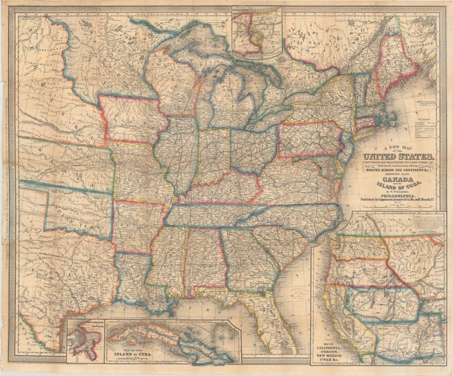
Auction 165, Lot 127
Subject: Eastern United States
Williams, Wellington
A New Map of the United States. Upon Which Are Delineated Its Vast Works of Internal Communication, with the Proposed Routes Across the Continents &c..., 1857
Size: 29.4 x 24.3 inches (74.7 x 61.7 cm)
Estimate: $400 - $500
Sold for: $300
Closed on 11/15/2017
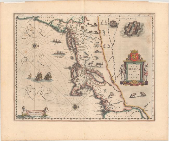
Auction 165, Lot 128
Subject: Colonial New England & Mid-Atlantic United States
Blaeu, Willem
Nova Belgica et Anglia Nova, 1635
Size: 19.9 x 15.3 inches (50.5 x 38.9 cm)
Estimate: $2,300 - $2,750
Important Map of Colonial New England and the Mid-Atlantic
Sold for: $1,200
Closed on 11/15/2017
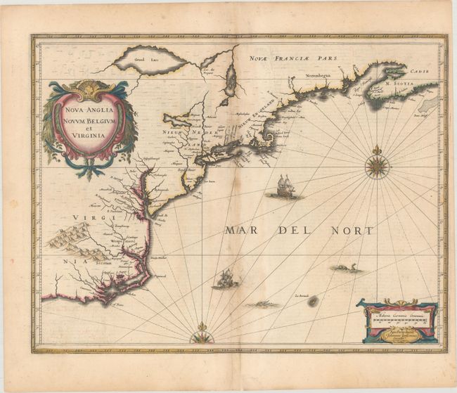
Auction 165, Lot 129
Subject: Colonial New England & Mid-Atlantic United States
Jansson, Jan
Nova Anglia Novum Belgium et Virginia, 1636
Size: 19.9 x 15.3 inches (50.5 x 38.9 cm)
Estimate: $1,200 - $1,500
Jansson's Influential Map of the East Coast
Sold for: $1,100
Closed on 11/15/2017
Auction 165, Lot 130
Subject: Colonial New England & Mid-Atlantic United States
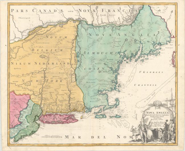
Homann, Johann Baptist
Nova Anglia Septentrionali Americae Implantata Anglorumque Coloniis Florentissima..., 1725
Size: 22.7 x 19.1 inches (57.7 x 48.5 cm)
Estimate: $1,200 - $1,500
Sold for: $700
Closed on 11/15/2017
Auction 165, Lot 131
Subject: Colonial New England & Mid-Atlantic United States
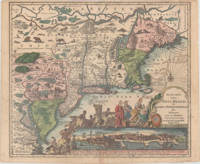
Seutter/Lotter
Recens Edita Totius Novi Belgii, in America Septentrionali siti, Delineatio Cura et Sumtibus, 1757
Size: 23 x 19.7 inches (58.4 x 50 cm)
Estimate: $2,500 - $3,250
Decorative Edition from Jansson-Visscher Series with View of Manhattan
Sold for: $1,600
Closed on 11/15/2017
240 lots
Page 1 of 5