Filtered by Category:Canada(Show All Categories)
Showing results for:Auction 165
Catalog Archive
19 lots
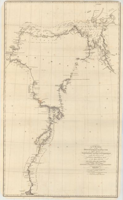
Auction 165, Lot 80
Subject: Northern Canada
Franklin, John [Rear Admiral Sir]
A Chart of the Discoveries & Route of the Northern Land Expedition, Under the Command of Captain Franklin, R.N. in the Years 1820 & 21..., 1823
Size: 18.9 x 31.8 inches (48 x 80.8 cm)
Estimate: $220 - $250
Sold for: $120
Closed on 11/15/2017
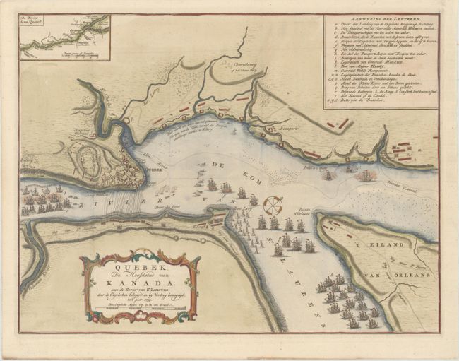
Auction 165, Lot 81
Subject: Quebec City, Canada
Tirion, Isaac
Quebek, de Hoofdstad van Kanada; aan de Rivier van St. Laurens..., 1759
Size: 17.1 x 13 inches (43.4 x 33 cm)
Estimate: $240 - $300
Sold for: $210
Closed on 11/15/2017
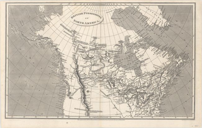
Auction 165, Lot 82
Subject: Northern United States & Canada
Arrowsmith, Aaron, Sr.
British Possessions in North America, 1809
Size: 15.7 x 9.8 inches (39.9 x 24.9 cm)
Estimate: $180 - $220
Sold for: $130
Closed on 11/15/2017
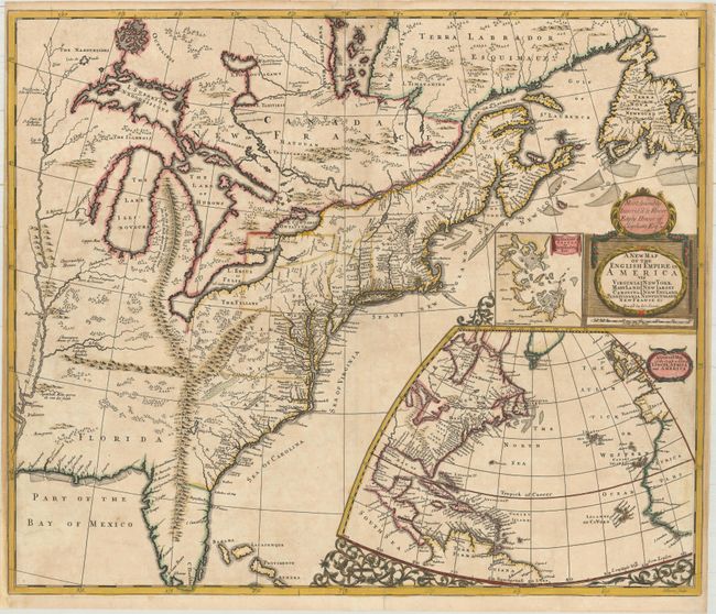
Auction 165, Lot 83
Subject: Colonial Eastern United States & Canada
Senex, John
A New Map of the English Empire in America viz Virginia New York Maryland New Iarsey Carolina New England Pennsylvania Newfoundland New France &c, 1719
Size: 23.6 x 19.9 inches (59.9 x 50.5 cm)
Estimate: $2,400 - $3,000
Important Map of the American Colonies
Unsold
Closed on 11/15/2017
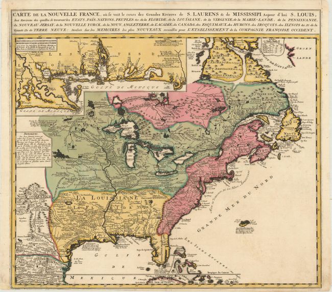
Auction 165, Lot 84
Subject: Colonial Eastern United States & Canada
Ottens/De Fer
Carte de la Nouvelle France, ou se voit le Cours des Grandes Rivieres de S. Laurens & de Mississipi Aujour d'hui S. Louis, aux Environs des Quelles se Trouvent les Etats, Pais, Nations, Peuples &c..., 1745
Size: 21.7 x 19.6 inches (55.1 x 49.8 cm)
Estimate: $2,000 - $2,300
Reduced Version of De Fer's Influential Map of French Possessions in North America
Sold for: $1,400
Closed on 11/15/2017
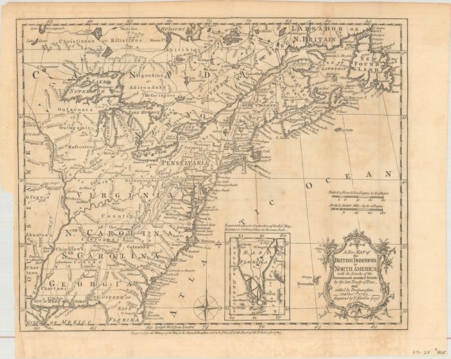
Auction 165, Lot 85
Subject: Colonial Eastern United States & Canada
Kitchin, Thomas
A New Map of the British Dominions in North America; with the Limits of the Governments Annexed Thereto by the Late Treaty of Peace, and Settled by Proclamation, October 7th 1763, 1763
Size: 11.9 x 9.6 inches (30.2 x 24.4 cm)
Estimate: $350 - $425
Sold for: $200
Closed on 11/15/2017
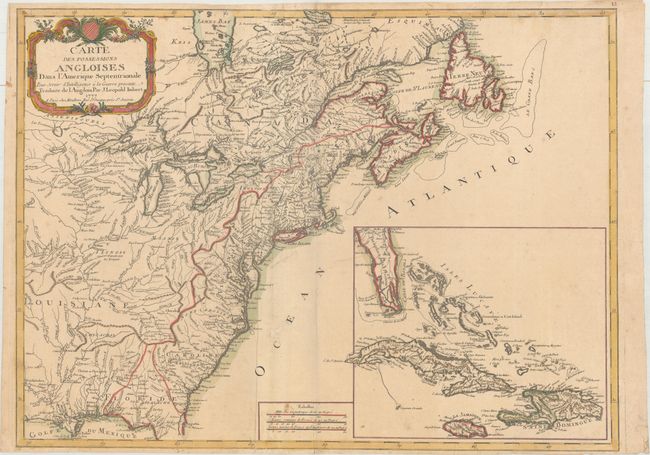
Auction 165, Lot 86
Subject: Colonial Eastern United States & Canada
Imbert, J. Leopold
Carte des Possessions Angloises dans l'Amerique Septentrionale pour Servir d'Intelligence a la Guerre Presente Traduite de l Angloise, 1777
Size: 28.9 x 21.3 inches (73.4 x 54.1 cm)
Estimate: $1,800 - $2,200
First Edition of Important Revolutionary War Map
Sold for: $1,100
Closed on 11/15/2017
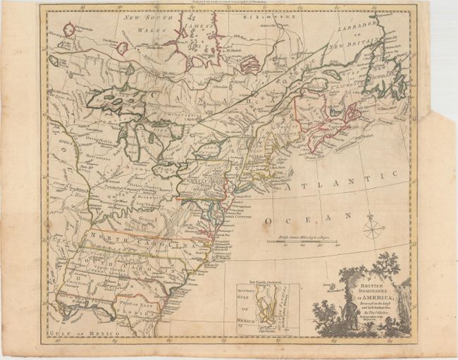
Auction 165, Lot 87
Subject: Colonial Eastern United States & Canada
Kitchin, Thomas
British Dominions in America, Drawn from the Latest and Best Authorities [with related text], 1782
Size: 14.8 x 13.4 inches (37.6 x 34 cm)
Estimate: $600 - $750
Unsold
Closed on 11/15/2017
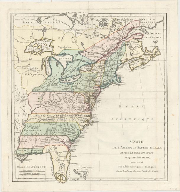
Auction 165, Lot 88
Subject: Colonial Eastern United States & Canada
Carte de l'Amerique Septentrionale, Depuis la Baye d'Hudson Jusqu'au Mississipi: pour Servir aux Essais Historiques et Politiques..., 1782
Size: 14.9 x 16.4 inches (37.8 x 41.7 cm)
Estimate: $400 - $500
Sold for: $300
Closed on 11/15/2017
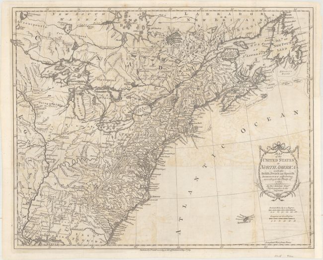
Auction 165, Lot 89
Subject: Eastern United States & Canada
Kitchin, Thomas
Map of the United States in North America: with the British, French and Spanish Dominions Adjoining, According to the Treaty of 1783, 1783
Size: 20.1 x 16.2 inches (51.1 x 41.1 cm)
Estimate: $1,000 - $1,300
One of the Earliest English-Produced Maps to Acknowledge the United States
Sold for: $550
Closed on 11/15/2017
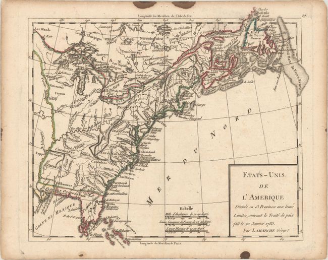
Auction 165, Lot 90
Subject: Eastern United States & Canada
Delamarche, Charles Francois
Etats-Unis de l'Amerique Divises en 13 Provinces avec leurs Limites, Suivant le Traite de Paix Fait le 20 Janvier 1783, 1790
Size: 9.3 x 8.1 inches (23.6 x 20.6 cm)
Estimate: $160 - $190
Sold for: $90
Closed on 11/15/2017
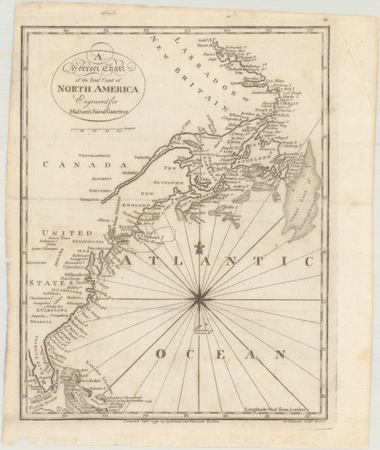
Auction 165, Lot 91
Subject: Eastern United States & Canada
Malham, John (Rev.)
A Correct Chart of the East Coast of North America, 1796
Size: 7.1 x 9.1 inches (18 x 23.1 cm)
Estimate: $120 - $150
Sold for: $90
Closed on 11/15/2017
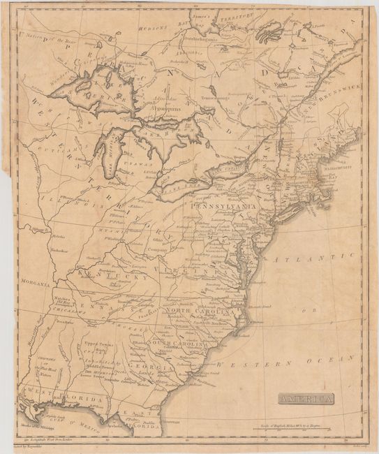
Auction 165, Lot 92
Subject: Eastern United States & Canada, Franklinia
America, 1805
Size: 12.9 x 15.9 inches (32.8 x 40.4 cm)
Estimate: $500 - $650
Unique Map Depicting Both Franklinia and Morgania
Sold for: $850
Closed on 11/15/2017
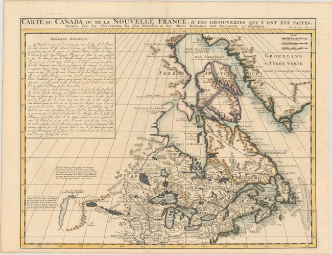
Auction 165, Lot 93
Subject: Colonial Northeastern United States & Canada
Chatelain, Henry Abraham
Carte du Canada ou de la Nouvelle France, & des Decouvertes qui y ont ete Faites, Dressee sur les Observations les Plus Nouvelles, & sur Divers Memoires tant Manuscrits qu' Imprimez, 1719
Size: 20.4 x 15.9 inches (51.8 x 40.4 cm)
Estimate: $600 - $750
Sold for: $400
Closed on 11/15/2017
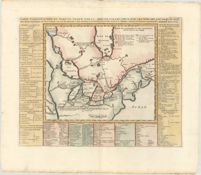
Auction 165, Lot 94
Subject: Colonial Northeastern United States & Canada, Great Lakes
Chatelain, Henry Abraham
Carte Particuliere du Fleuve Saint Louis. Dressee sur les Lieux avec les Noms des Sauvages du Pais..., 1720
Size: 18 x 14.4 inches (45.7 x 36.6 cm)
Estimate: $600 - $750
Sold for: $500
Closed on 11/15/2017
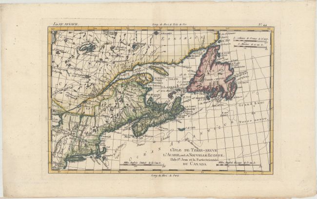
Auction 165, Lot 95
Subject: Northeastern United States & Canada
Bonne, Rigobert
L'Isle de Terre-Neuve l'Acadie, ou la Nouvelle Ecosse, l'Isle St. Jean et la Partie Orientale du Canada, 1783
Size: 12.4 x 8.2 inches (31.5 x 20.8 cm)
Estimate: $200 - $230
Unsold
Closed on 11/15/2017
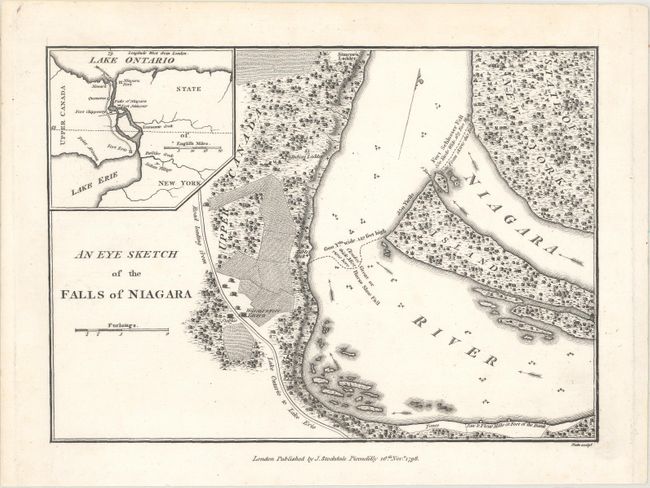
Auction 165, Lot 96
Subject: New York, Canada, Niagara Falls
[Lot of 5 - Niagara Falls], 1798-1928
Size: See Description
Estimate: $300 - $375
Sold for: $200
Closed on 11/15/2017
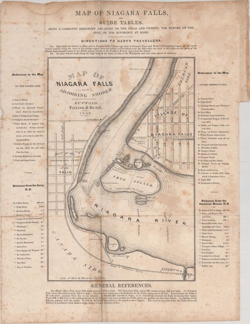
Auction 165, Lot 97
Subject: New York, Canada
The Travellers' Own Book, to Saratoga Springs, Niagara Falls and Canada, Containing Routes, Distances, Conveyances, Expenses, Use of Mineral Waters, Baths, Description of Scenery, Etc..., 1842
Size: 4.1 x 6 inches (10.4 x 15.2 cm)
Estimate: $140 - $170
Sold for: $100
Closed on 11/15/2017
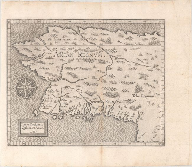
Auction 165, Lot 98
Subject: Alaska & Western Canada
Wytfliet, Cornelis
Limes Occidentis Quivira et Anian, 1597
Size: 11.4 x 9.1 inches (29 x 23.1 cm)
Estimate: $1,800 - $2,100
Early and Imaginary Map of Alaska and the Northwest Passage
Sold for: $1,300
Closed on 11/15/2017
19 lots