Filtered by Category:United States(Show All Categories)
Showing results for:Auction 153
Catalog Archive
243 lots
Page 1 of 5

Auction 153, Lot 117
Subject: Colonial United States & Canada
Euler, Leonhard
Americae Septentrionalis Pars I, 1753
Size: 14.3 x 13.6 inches (36.3 x 34.5 cm)
Estimate: $400 - $500
NO RESERVE
Sold for: $220
Closed on 5/20/2015
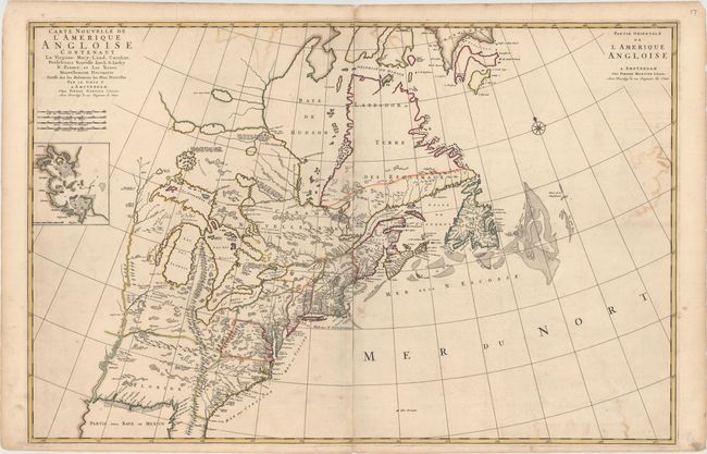
Auction 153, Lot 118
Subject: Colonial Eastern United States & Canada
Mortier, Pierre
Carte Nouvelle de l'Amerique Angloise Contenant la Virginie, Mary-Land, Caroline, Pensylvania Nouvelle Iorck, N: Iarsey N: France, et les Terres Nouvellement Decouerte..., 1700
Size: 35.8 x 23.4 inches (90.9 x 59.4 cm)
Estimate: $2,400 - $3,000
A Map Showing Fascinating Geographic Misconceptions
Unsold
Closed on 5/20/2015
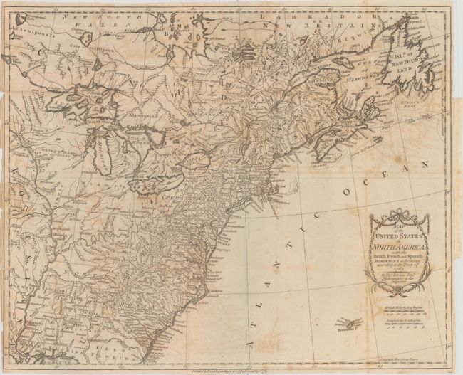
Auction 153, Lot 119
Subject: Eastern United States & Canada
Kitchin, Thomas
Map of the United States in North America: with the British, French and Spanish Dominions Adjoining, According to the Treaty of 1783, 1783
Size: 19.7 x 16 inches (50 x 40.6 cm)
Estimate: $1,400 - $1,700
One of the Earliest English-Produced Maps to Acknowledge the United States
Sold for: $750
Closed on 5/20/2015
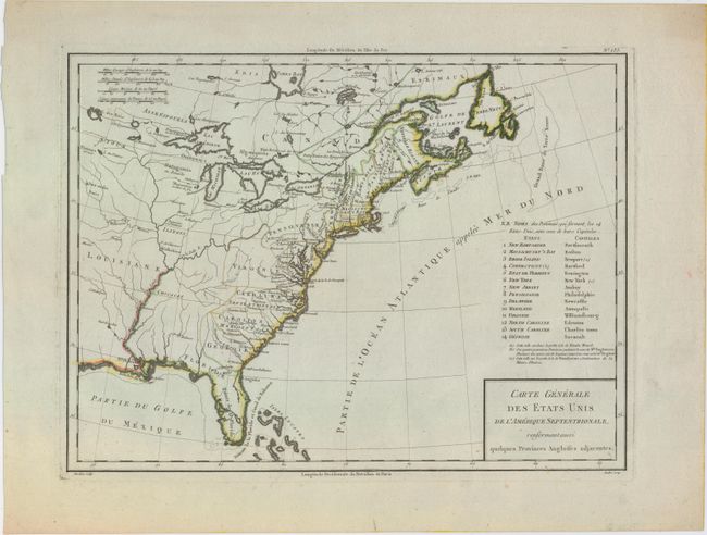
Auction 153, Lot 120
Subject: Eastern United States & Canada
Tardieu, Pierre Francois
Carte Generale des Etats Unis de l'Amerique Septentrionale, Renfermant Aussi Quelques Provinces Angloises Adjacentes, 1797
Size: 17 x 12.7 inches (43.2 x 32.3 cm)
Estimate: $250 - $325
Sold for: $325
Closed on 5/20/2015

Auction 153, Lot 121
Subject: Eastern United States & Canada
Anon.
The United States of North America with the British Territorys, 1800
Size: 7.9 x 9.3 inches (20.1 x 23.6 cm)
Estimate: $150 - $180
Sold for: $75
Closed on 5/20/2015
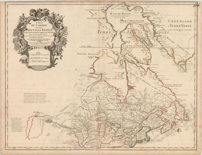
Auction 153, Lot 122
Subject: Colonial Northeastern United States & Canada, Great Lakes
Delisle, Guillaume
Carte du Canada ou de la Nouvelle France et des Decouvertes qui y ont ete Faites..., 1703
Size: 25.5 x 19.6 inches (64.8 x 49.8 cm)
Estimate: $2,200 - $2,500
Delisle's Seminal Map of Canada and the Great Lakes
Sold for: $1,400
Closed on 5/20/2015
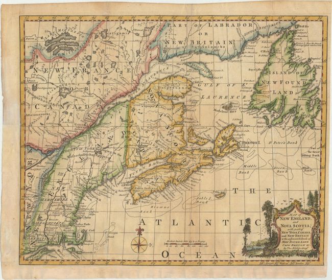
Auction 153, Lot 123
Subject: Colonial Northeastern United States & Canada
Kitchin, Thomas
A Map of New England, and Nova Scotia; with Part of New York, Canada, and New Britain & the Adjacent Islands of New Found Land Cape Breton &c., 1758
Size: 13 x 10.6 inches (33 x 26.9 cm)
Estimate: $200 - $230
Sold for: $240
Closed on 5/20/2015

Auction 153, Lot 124
Subject: Colonial Northeastern United States & Canada
Gibson, John
A Particular Map, to Illustrate Gen. Amherst's Expedition, to Montreal; with a Plan of the Town & Draught of ye Island, 1760
Size: 9 x 7.2 inches (22.9 x 18.3 cm)
Estimate: $140 - $180
Sold for: $80
Closed on 5/20/2015

Auction 153, Lot 125
Subject: Colonial Northeastern United States & Canada
Jefferys/Sayer & Bennett
An Exact Chart of the River St. Laurence, from Fort Frontenac to the Island of Anticosti Shewing the Soundings, Rocks, Shoals, &c. with Views of the Lands and All Necessary Instructions for Navigating that River to Quebec, 1775
Size: 37.5 x 23.5 inches (95.3 x 59.7 cm)
Estimate: $700 - $850
Sold for: $500
Closed on 5/20/2015
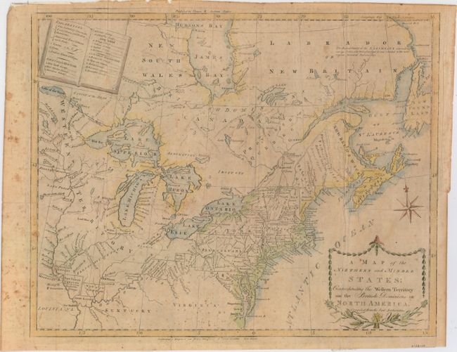
Auction 153, Lot 126
Subject: Northeastern United States & Canada
Doolittle, Amos
A Map of the Northern and Middle States: Comprehending the Western Territory and the British Dominions in North America, Compiled from the Best Authorities, 1793
Size: 16 x 12.5 inches (40.6 x 31.8 cm)
Estimate: $550 - $700
Sold for: $300
Closed on 5/20/2015
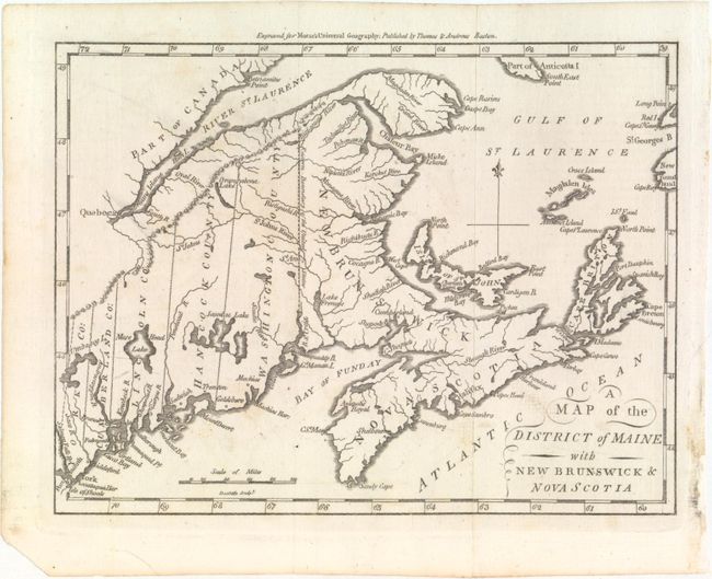
Auction 153, Lot 127
Subject: Northeastern United States & Canada
Morse, Jedidiah (Rev.)
A Map of the District of Maine with New Brunswick & Nova Scotia, 1796
Size: 9.1 x 6.9 inches (23.1 x 17.5 cm)
Estimate: $200 - $240
Unsold
Closed on 5/20/2015
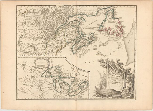
Auction 153, Lot 128
Subject: Northeastern United States & Canada, Great Lakes
Robert de Vaugondy, Didier
Partie de l'Amerique Septent? qui Comprend la Nouvelle France ou le Canada, 1799
Size: 23.8 x 19.1 inches (60.5 x 48.5 cm)
Estimate: $700 - $850
Sold for: $700
Closed on 5/20/2015

Auction 153, Lot 129
Subject: Northeastern United States & Canada
Basire, James III
[Rideau Canal] Estimates. Water Communication in Canada., 1827
Size: 8 x 7 inches (20.3 x 17.8 cm)
Estimate: $140 - $170
Sold for: $110
Closed on 5/20/2015

Auction 153, Lot 130
Subject: Western United States & Canada
Imray, James
West Coast of North America from San Francisco to Queen Charlotte Ids., 1884
Size: 40 x 49.8 inches (101.6 x 126.5 cm)
Estimate: $700 - $850
Sold for: $300
Closed on 5/20/2015
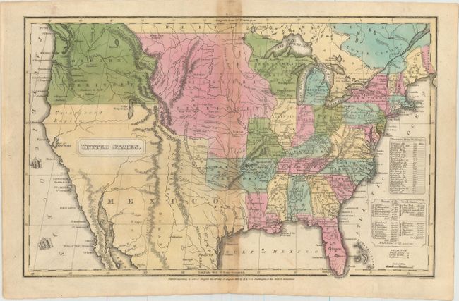
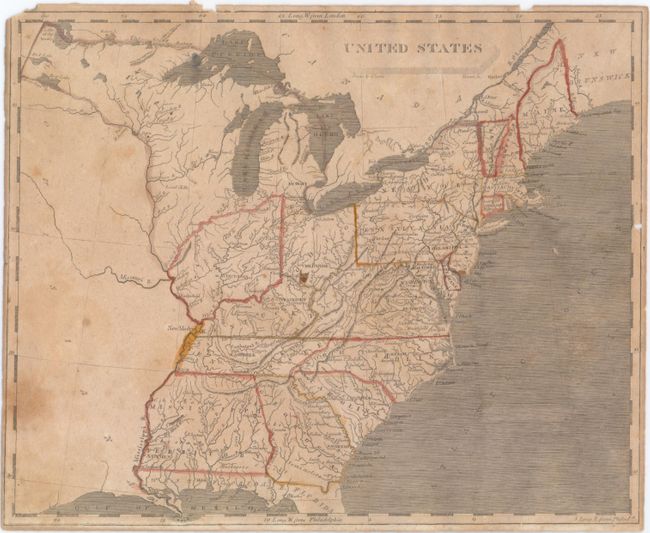
Auction 153, Lot 131
Subject: United States
Morse, Jedidiah & Sydney
United States, 1822
Size: 17 x 10.5 inches (43.2 x 26.7 cm)
Estimate: $400 - $500
Sold for: $250
Closed on 5/20/2015
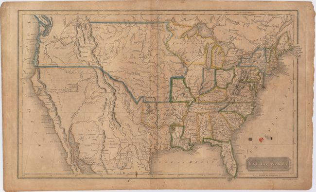
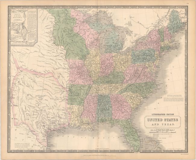
Auction 153, Lot 132
Subject: United States
Huntington, F. J.
[Lot of 4] United States [and] The Western States [and] The Middle States Maryland & Virginia [and] Southern States, 1830-32
Size: See Description
Estimate: $150 - $180
Sold for: $210
Closed on 5/20/2015

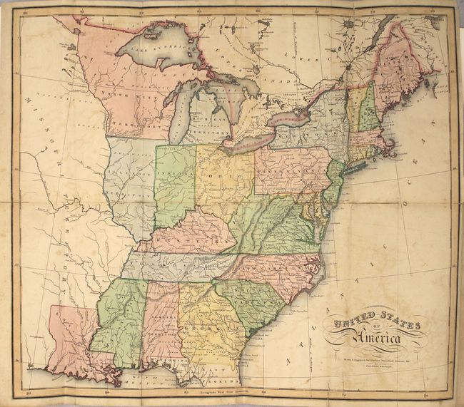
Auction 153, Lot 133
Subject: United States, Texas & Mexico
Robinson, D.F. & Co.
Map of the United States Canada, Texas & Part of Mexico. To Illustrate Olney's School Geography, 1844
Size: 17.4 x 11 inches (44.2 x 27.9 cm)
Estimate: $240 - $325
Features Independent Republic of Texas
Sold for: $1,300
Closed on 5/20/2015
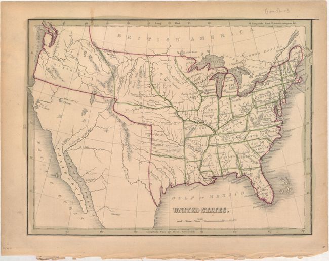
Auction 153, Lot 134
Subject: United States
Bradford, Thomas Gamaliel
United States, 1845
Size: 10.1 x 7.7 inches (25.7 x 19.6 cm)
Estimate: $110 - $140
Sold for: $75
Closed on 5/20/2015

Auction 153, Lot 135
Subject: United States
Marzolla, Benedetto
Stati-Uniti dell' America Settentrionale Coi Territorii Recentemente Annessi, 1854
Size: 24.3 x 17.1 inches (61.7 x 43.4 cm)
Estimate: $275 - $375
Unsold
Closed on 5/20/2015
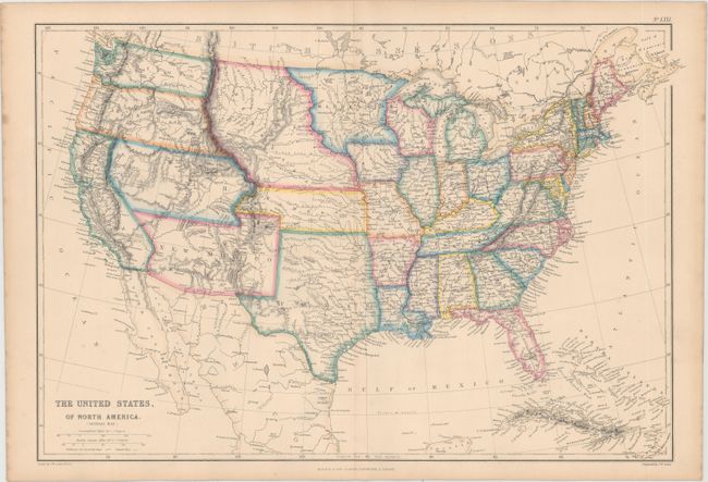
Auction 153, Lot 136
Subject: United States
Blackie, W. G. & Son
The United States, of North America. (General Map.), 1855
Size: 19.7 x 13.6 inches (50 x 34.5 cm)
Estimate: $220 - $275
Sold for: $300
Closed on 5/20/2015

Auction 153, Lot 137
Subject: United States
Ettling, Theodor
Map of the United States of North America, Upper & Lower Canada New Brunswick, Nova Scotia & British Columbia. Mexico Cuba, Jamaica, St. Domingo and the Bahama Islands, 1861
Size: 36.8 x 26 inches (93.5 x 66 cm)
Estimate: $350 - $450
Great Civil War Period Map of the United States
Sold for: $180
Closed on 5/20/2015
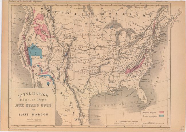
Auction 153, Lot 138
Subject: United States
Marcou, Jules
Distribution de l'Or et de l'Argent aux Etats Unis, 1867
Size: 11 x 7.9 inches (27.9 x 20.1 cm)
Estimate: $220 - $250
Sold for: $90
Closed on 5/20/2015
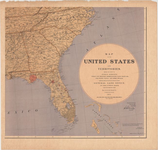
Auction 153, Lot 139
Subject: United States
General Land Office
[On 6 Sheets] Map of the United States and Territories, Showing the Extent of Public Surveys..., 1875
Size: 24 x 25.3 inches (61 x 64.3 cm)
Estimate: $1,800 - $2,200
Burdett's Rare Six-Sheet Map of the United States
Sold for: $1,300
Closed on 5/20/2015

Auction 153, Lot 140
Subject: United States
U.S. Geological Survey (USGS)
Map of the United States Exhibiting the Present Status of Knowledge Relating to the Areal Distribution of Geologic Groups, 1884
Size: 28 x 17.3 inches (71.1 x 43.9 cm)
Estimate: $200 - $250
Sold for: $130
Closed on 5/20/2015

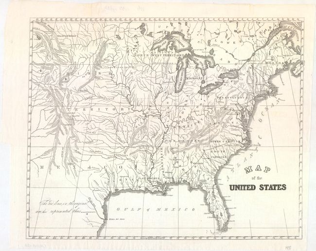
Auction 153, Lot 141
Subject: United States
Hitchcock, Charles Henry
Geological Map of the United States and Part of Canada… [bound in] Transactions of the American Institute of Mining Engineers. Vol. XV, 1886
Size: 27.8 x 17.3 inches (70.6 x 43.9 cm)
Estimate: $500 - $650
Sold for: $300
Closed on 5/20/2015

Auction 153, Lot 142
Subject: United States, Railroads
Railroad Companies, (Various)
Burlington Route, 1892
Size: 44.1 x 27.6 inches (112 x 70.1 cm)
Estimate: $275 - $350
Sold for: $140
Closed on 5/20/2015

Auction 153, Lot 143
Subject: United States
U.S.D.A.
[Lot of 44 - U.S.D.A. Soil Maps], 1902
Size: 6.3 x 9.4 inches (16 x 23.9 cm)
Estimate: $400 - $500
Sold for: $200
Closed on 5/20/2015

Auction 153, Lot 144
Subject: Colonial Eastern United States
Gibson, John
[Untitled - North America, Louisiana, Virginia & Carolina], 1763
Size: 9.5 x 7.1 inches (24.1 x 18 cm)
Estimate: $220 - $250
Sold for: $275
Closed on 5/20/2015
Auction 153, Lot 145
Subject: Eastern United States
Arrowsmith & Lewis
United States, 1804
Size: 9.9 x 8 inches (25.1 x 20.3 cm)
Estimate: $180 - $220
Sold for: $130
Closed on 5/20/2015
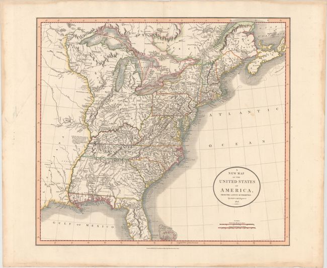
Auction 153, Lot 146
Subject: Eastern United States
Cary, John
A New Map of the United States of America, from the Latest Authorities, 1806
Size: 20 x 17.8 inches (50.8 x 45.2 cm)
Estimate: $700 - $850
Sold for: $500
Closed on 5/20/2015
Auction 153, Lot 147
Subject: Eastern United States
Lizars, William Home
United States of America [bound in] The Western Gazetteer; or Emigrant's Directory. Containing a Geographical Description of the Western States and Territories, Viz. The States of Kentucky, Indiana…, 1819
Size: 17.8 x 15.3 inches (45.2 x 38.9 cm)
Estimate: $600 - $750
Sold for: $450
Closed on 5/20/2015
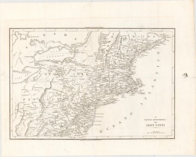
Auction 153, Lot 148
Subject: Eastern United States
Anon.
[Lot of 2] Le Provincie Settentrionali degli Stati Uniti [with] Le Provincie Meridionali degli Stati Uniti, 1826
Size: 17.4 x 12.4 inches (44.2 x 31.5 cm)
Estimate: $350 - $450
Unsold
Closed on 5/20/2015

Auction 153, Lot 149
Subject: Eastern United States
Hall, Sidney
Map of the United States, Engraved for the Modern Traveller, 1830
Size: 7.6 x 6.7 inches (19.3 x 17 cm)
Estimate: $110 - $140
Sold for: $55
Closed on 5/20/2015
Auction 153, Lot 150
Subject: Eastern United States
[Lot of 2] Map of the United States [and] Map of the United States. Engraved for Buckingham's America, 1838-41
Size: See Description
Estimate: $160 - $190
Unsold
Closed on 5/20/2015
Auction 153, Lot 151
Subject: Eastern United States, Texas
Johnston, Alexander K.
United States and Texas, 1845
Size: 24.3 x 19.8 inches (61.7 x 50.3 cm)
Estimate: $1,000 - $1,200
Sold for: $1,100
Closed on 5/20/2015

Auction 153, Lot 152
Subject: Eastern United States
Wyld, James
Map of the United States of North America, 1860
Size: 10.8 x 8.6 inches (27.4 x 21.8 cm)
Estimate: $160 - $200
Unsold
Closed on 5/20/2015
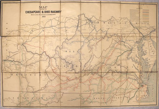
Auction 153, Lot 153
Subject: Eastern United States, Railroads
Railroad Companies, (Various)
Map Showing the Chesapeake & Ohio Railway Main Line, Branches & Connections, 1902
Size: 42.4 x 28.2 inches (107.7 x 71.6 cm)
Estimate: $150 - $180
Sold for: $85
Closed on 5/20/2015
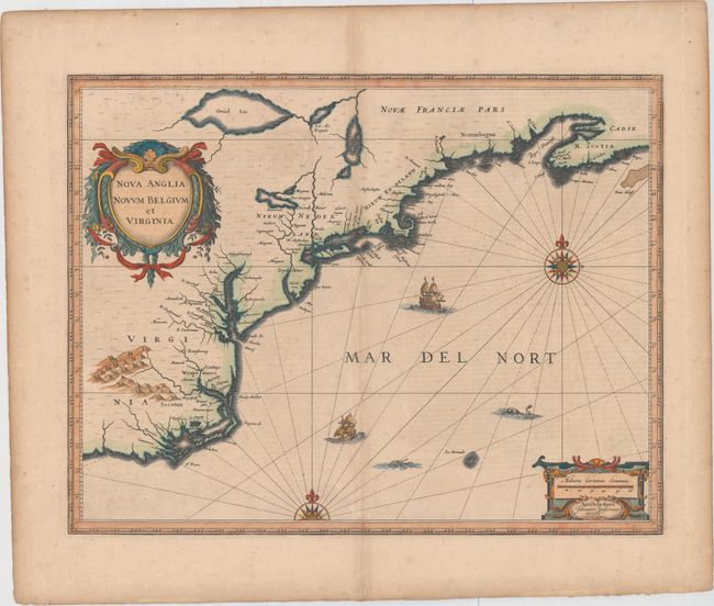
Auction 153, Lot 154
Subject: Colonial New England & Mid-Atlantic United States
Jansson, Jan
Nova Anglia Novum Belgium et Virginia, 1639
Size: 19.8 x 15.3 inches (50.3 x 38.9 cm)
Estimate: $1,800 - $2,100
Jansson's Influential Map of the East Coast
Sold for: $1,200
Closed on 5/20/2015

Auction 153, Lot 155
Subject: Colonial New England & Mid-Atlantic United States
Montanus, Arnoldus
Novi Belgii, quod nunc Novi Jorck Vocatur, Novae qz. Angliae & Partis Virginiae Accuratissima et Novissima Delineatio, 1671
Size: 14.4 x 11.4 inches (36.6 x 29 cm)
Estimate: $1,500 - $1,800
Sold for: $1,300
Closed on 5/20/2015
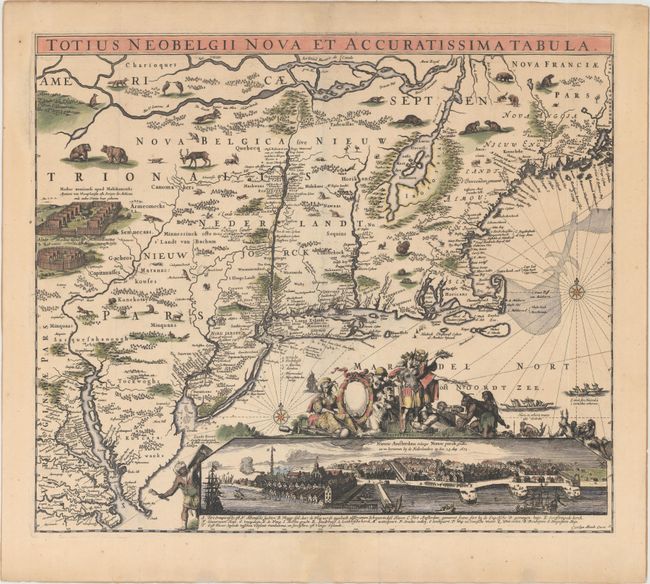
Auction 153, Lot 156
Subject: Colonial New England & Mid-Atlantic
Allard, Carel
Totius Neobelgii Nova et Accuratissima Tabula, 1680
Size: 21.3 x 18.3 inches (54.1 x 46.5 cm)
Estimate: $10,000 - $12,000
Rare Map of New England with Famous "Restitutio" View of New York City
Unsold
Closed on 5/20/2015

Auction 153, Lot 157
Subject: Colonial New England & Mid-Atlantic United States
Bellin, Jacques Nicolas
Carte de la Nouvelle Angleterre, Nouvelle York et Pensilvanie pour Servir a l'Histoire Generale des Voyages, 1757
Size: 11.5 x 7.9 inches (29.2 x 20.1 cm)
Estimate: $180 - $220
Sold for: $130
Closed on 5/20/2015

Auction 153, Lot 158
Subject: Colonial New England & Mid-Atlantic United States
Lodge, John
A New and Accurate Map of the Province of New York and Part of the Jerseys, New England and Canada, Shewing the Scenes of Our Military Operations During the Present War. Also the New Erected State of Vermont., 1780
Size: 10.8 x 14.5 inches (27.4 x 36.8 cm)
Estimate: $700 - $900
Sold for: $950
Closed on 5/20/2015
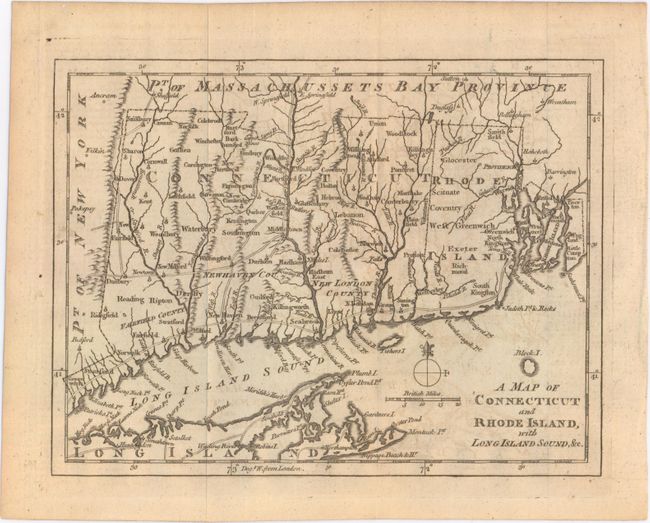
Auction 153, Lot 159
Subject: Colonial New England - United States, Revolutionary War
Anon.
A Map of Connecticut and Rhode Island, with Long Island Sound, &c., 1776
Size: 9 x 6.9 inches (22.9 x 17.5 cm)
Estimate: $180 - $220
Sold for: $130
Closed on 5/20/2015

Auction 153, Lot 160
Subject: New England - United States, Connecticut River
Hitchcock, Edward
A Geological Map of the Connecticut [bound in] The American Journal of Science, and Arts ... Vol. VI, 1823
Size: 7.5 x 22 inches (19.1 x 55.9 cm)
Estimate: $160 - $200
Sold for: $130
Closed on 5/20/2015
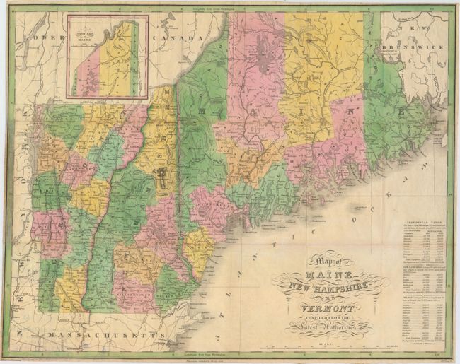
Auction 153, Lot 161
Subject: New England - United States
Finley, Anthony
Map of Maine New Hampshire and Vermont, Compiled from the Latest Authorities, 1826
Size: 21.4 x 16.9 inches (54.4 x 42.9 cm)
Estimate: $350 - $425
Unsold
Closed on 5/20/2015
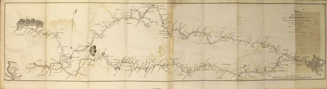
Auction 153, Lot 162
Subject: New England - United States, Railroads
Report of the Board of Directors of Internal Improvements of the State of Massachusetts on the Practicability and Expediency of a Rail-Road from Boston to the Hudson River..., 1829
Size: 5.7 x 9.1 inches (14.5 x 23.1 cm)
Estimate: $700 - $900
Unsold
Closed on 5/20/2015

Auction 153, Lot 163
Subject: New England - United States
Hitchcock, Edward
[Lot of 2] Ichnogeological Map of the Connecticut Valley [and] The Moody Foot Mark Quarry, South Hadley, 1858
Size: See Description
Estimate: $450 - $550
Unsold
Closed on 5/20/2015

Auction 153, Lot 164
Subject: New Hampshire & Vermont
Morse, Jedidiah (Rev.)
A Map of the States of New Hampshire and Vermont, 1796
Size: 9.2 x 7.4 inches (23.4 x 18.8 cm)
Estimate: $140 - $170
Sold for: $90
Closed on 5/20/2015
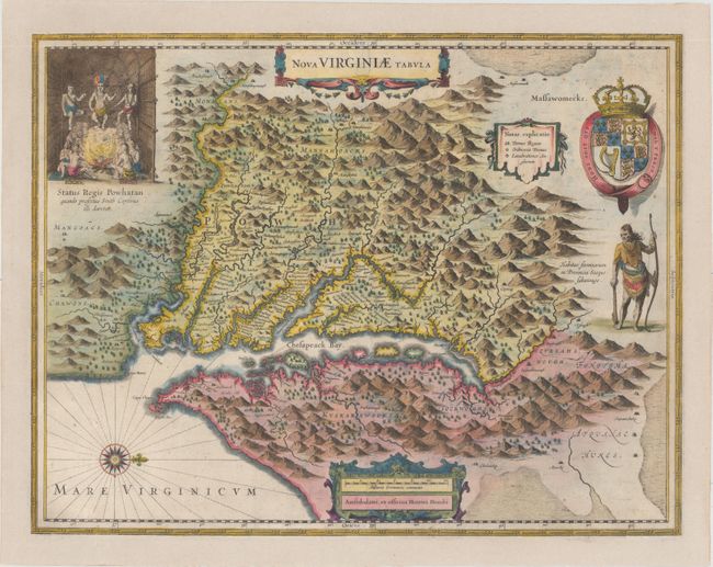
Auction 153, Lot 165
Subject: Colonial Mid-Atlantic United States
Hondius, Henricus
Nova Virginiae Tabula, 1630
Size: 19.5 x 15.2 inches (49.5 x 38.6 cm)
Estimate: $2,000 - $2,300
One of the Most Important 17th Century Maps of the Chesapeake Bay
Sold for: $1,400
Closed on 5/20/2015
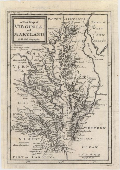
Auction 153, Lot 166
Subject: Colonial Mid-Atlantic United States, Virginia & Maryland
Moll, Herman
A New Map of Virginia, and Maryland, 1708
Size: 6.9 x 10.1 inches (17.5 x 25.7 cm)
Estimate: $600 - $750
First Edition
Sold for: $450
Closed on 5/20/2015
243 lots
Page 1 of 5