Filtered by Category:Canada(Show All Categories)
Showing results for:Auction 153
Catalog Archive
33 lots

Auction 153, Lot 98
Subject: Canada
Carey & Lea
Geographical, Statistical, and Historical Map of Upper and Lower Canada, and the Other British Possessions in North America, 1822
Size: 14.2 x 9.8 inches (36.1 x 24.9 cm)
Estimate: $160 - $190
Sold for: $120
Closed on 5/20/2015
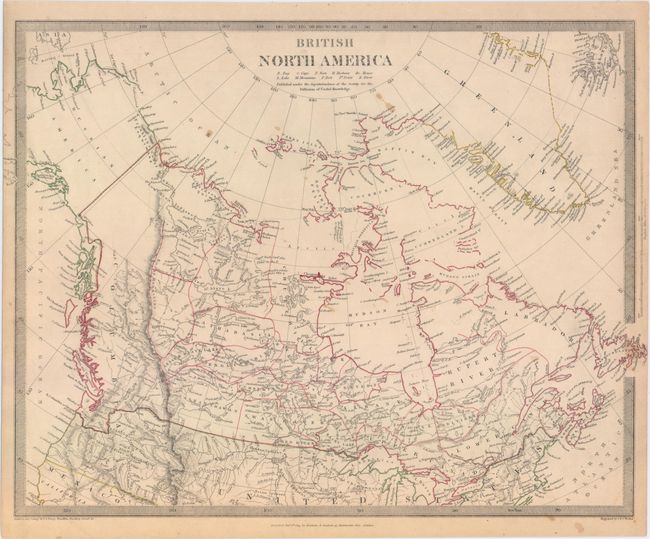
Auction 153, Lot 99
Subject: Canada
[Lot of 3] British North America [and] Carte Geographique, Statistique et Historique des Possessions Anglaises [and] British North America, 1825-34
Size: See Description
Estimate: $160 - $200
Sold for: $50
Closed on 5/20/2015

Auction 153, Lot 100
Subject: Canada, Alaska
Tallis, John
British America, 1850
Size: 12.9 x 10.1 inches (32.8 x 25.7 cm)
Estimate: $240 - $300
Unsold
Closed on 5/20/2015

Auction 153, Lot 101
Subject: Northern Canada, Arctic Regions
Franklin, John [Rear Admiral Sir]
The Discoveries of the Expedition Under the Command of Captain Franklin R.N. Near the Mouth of the Mackenzie River..., 1828
Size: 50.8 x 27.6 inches (129 x 70.1 cm)
Estimate: $700 - $850
Sold for: $300
Closed on 5/20/2015
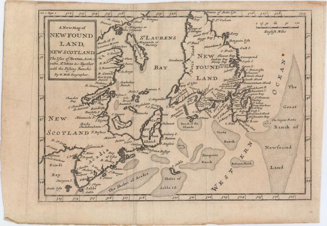
Auction 153, Lot 102
Subject: Eastern Canada
Moll, Herman
A New Map of New Found Land, New Scotland the Isles of Breton, Anticoste, St. Iohns &c. Together with the Fishing Bancks, 1741
Size: 10.2 x 7.1 inches (25.9 x 18 cm)
Estimate: $160 - $190
Sold for: $120
Closed on 5/20/2015

Auction 153, Lot 103
Subject: Eastern Canada
Robert de Vaugondy, Didier
Carte qui Represente les Differentes Connoissances que l'on a Eues des Terres Arctiques Depuis 1650 Jusqu'en 1747 Ausquelles il Faut Comparer la Carte Suivante, 1773
Size: 15.1 x 12 inches (38.4 x 30.5 cm)
Estimate: $80 - $110
NO RESERVE
Sold for: $30
Closed on 5/20/2015
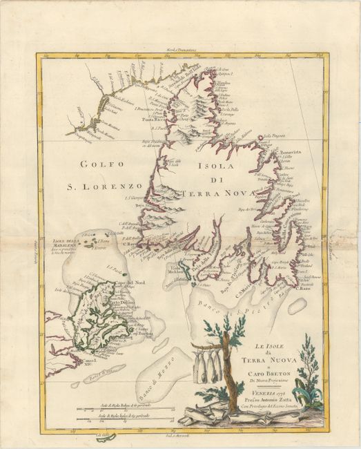
Auction 153, Lot 104
Subject: Eastern Canada
Zatta, Antonio
Le Isole di Terra Nuova e Capo Breton di Nuova Projezione, 1778
Size: 12.6 x 17 inches (32 x 43.2 cm)
Estimate: $325 - $400
Sold for: $325
Closed on 5/20/2015
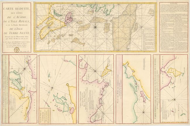
Auction 153, Lot 105
Subject: Eastern Canada
Chabert de Cogolin, Joseph Bernard Marquis de
Carte Reduite des Cotes de l'Acadie, de l'Isle Royale, et de la Partie Meridionale de l'Isle de Terre-Neuve..., 1784
Size: 34 x 22.4 inches (86.4 x 56.9 cm)
Estimate: $500 - $650
Unsold
Closed on 5/20/2015
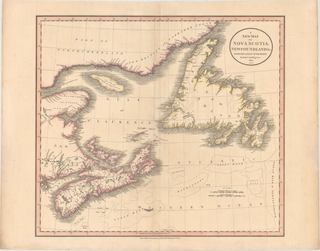
Auction 153, Lot 106
Subject: Eastern Canada
Cary, John
A New Map of Nova Scotia, Newfoundland &c. From the Latest Authorities, 1807
Size: 20.5 x 18.1 inches (52.1 x 46 cm)
Estimate: $275 - $350
Sold for: $210
Closed on 5/20/2015
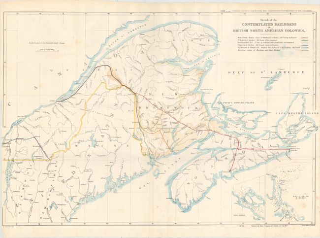
Auction 153, Lot 107
Subject: Eastern Canada, Railroads
Arrowsmith, John
[Lot of 2] Sketch of the Contemplated Railroads in British North American Colonies [and] Map (for Mercator's Projection) Shewing the Several Proposed Lines of Railroad, in the North American Provinces of Nova Scotia, New Brunswick and Part of Canada, 1847-49
Size: See Description
Estimate: $200 - $250
Unsold
Closed on 5/20/2015

Auction 153, Lot 108
Subject: Eastern Canada
[Lot of 2] Chart of the Inshore & Deep-Sea Fishing Grounds on the Atlantic Coasts of Canada and Within the Gulf of St. Lawrence [and] Newfoundland, 1878
Size: See Description
Estimate: $150 - $200
Unsold
Closed on 5/20/2015
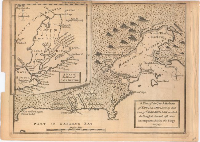
Auction 153, Lot 109
Subject: Nova Scotia, Canada
Anon.
A Plan of the City & Harbour of Louisburg; Shewing that Part of Gabarus Bay in which the English Landed, also Their Encampment During the Siege in 1745, 1758
Size: 10 x 7.5 inches (25.4 x 19.1 cm)
Estimate: $120 - $150
Unsold
Closed on 5/20/2015

Auction 153, Lot 110
Subject: Quebec City, Canada
Gibson, John
An Authentic Plan of the River St. Laurence, from Sillery to the Falls of Montmorency, 1759
Size: 7.4 x 4.3 inches (18.8 x 10.9 cm)
Estimate: $140 - $180
Sold for: $70
Closed on 5/20/2015

Auction 153, Lot 111
Subject: Quebec City, Canada
Tirion, Isaac
Quebek, de Hoofdstad van Kanada; aan de Rivier van St. Laurens..., 1759
Size: 16.9 x 12.9 inches (42.9 x 32.8 cm)
Estimate: $300 - $375
Sold for: $110
Closed on 5/20/2015

Auction 153, Lot 112
Subject: Quebec City, Canada
Walker & Miles
Map of the City of Quebec, 1875
Size: 15.1 x 12.6 inches (38.4 x 32 cm)
Estimate: $140 - $170
Unsold
Closed on 5/20/2015

Auction 153, Lot 113
Subject: Montreal, Canada
Anon.
Plan of the Town & Fortifications of Montreal, or Ville Marie in Canada, 1760
Size: 9.8 x 6.6 inches (24.9 x 16.8 cm)
Estimate: $220 - $250
Sold for: $150
Closed on 5/20/2015

Auction 153, Lot 114
Subject: St. Lawrence River, Canada
Kitchin, Thomas
A New Chart of the River St. Lawrence from the Island of Anticosti to Lake Ontario, 1759
Size: 10.1 x 7.2 inches (25.7 x 18.3 cm)
Estimate: $140 - $170
Unsold
Closed on 5/20/2015
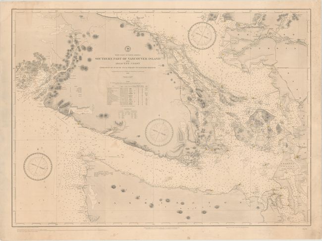
Auction 153, Lot 115
Subject: Vancouver Island, Canada
U.S. Hydrographic Office
West Coast of North America Southern Part of Vancouver Island and Adjacent Coast Entrance of Juan de Fuca Strait to Nanaimo Harbor..., 1895
Size: 36.6 x 26.9 inches (93 x 68.3 cm)
Estimate: $275 - $350
Sold for: $160
Closed on 5/20/2015

Auction 153, Lot 116
Subject: Vancouver Island, Canada
British Admiralty
North America West Coast Vancouver Island Esquimalt Harbour Surveyed by Captn. G.H. Richards & the Officers of H.M.S. Plumper..., 1897
Size: 24.9 x 40.3 inches (63.2 x 102.4 cm)
Estimate: $550 - $700
Unsold
Closed on 5/20/2015

Auction 153, Lot 117
Subject: Colonial United States & Canada
Euler, Leonhard
Americae Septentrionalis Pars I, 1753
Size: 14.3 x 13.6 inches (36.3 x 34.5 cm)
Estimate: $400 - $500
NO RESERVE
Sold for: $220
Closed on 5/20/2015
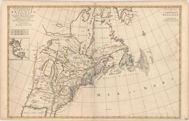
Auction 153, Lot 118
Subject: Colonial Eastern United States & Canada
Mortier, Pierre
Carte Nouvelle de l'Amerique Angloise Contenant la Virginie, Mary-Land, Caroline, Pensylvania Nouvelle Iorck, N: Iarsey N: France, et les Terres Nouvellement Decouerte..., 1700
Size: 35.8 x 23.4 inches (90.9 x 59.4 cm)
Estimate: $2,400 - $3,000
A Map Showing Fascinating Geographic Misconceptions
Unsold
Closed on 5/20/2015
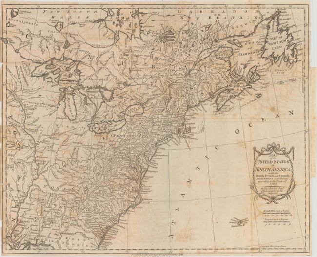
Auction 153, Lot 119
Subject: Eastern United States & Canada
Kitchin, Thomas
Map of the United States in North America: with the British, French and Spanish Dominions Adjoining, According to the Treaty of 1783, 1783
Size: 19.7 x 16 inches (50 x 40.6 cm)
Estimate: $1,400 - $1,700
One of the Earliest English-Produced Maps to Acknowledge the United States
Sold for: $750
Closed on 5/20/2015
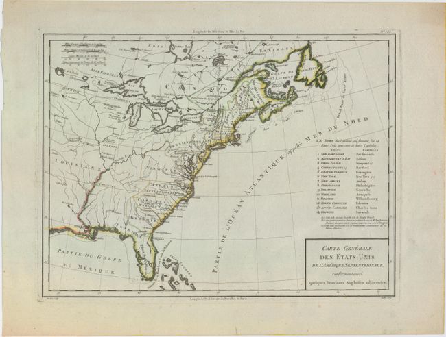
Auction 153, Lot 120
Subject: Eastern United States & Canada
Tardieu, Pierre Francois
Carte Generale des Etats Unis de l'Amerique Septentrionale, Renfermant Aussi Quelques Provinces Angloises Adjacentes, 1797
Size: 17 x 12.7 inches (43.2 x 32.3 cm)
Estimate: $250 - $325
Sold for: $325
Closed on 5/20/2015

Auction 153, Lot 121
Subject: Eastern United States & Canada
Anon.
The United States of North America with the British Territorys, 1800
Size: 7.9 x 9.3 inches (20.1 x 23.6 cm)
Estimate: $150 - $180
Sold for: $75
Closed on 5/20/2015
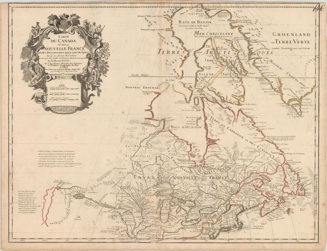
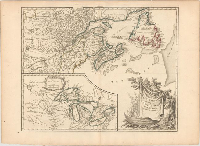
Auction 153, Lot 122
Subject: Colonial Northeastern United States & Canada, Great Lakes
Delisle, Guillaume
Carte du Canada ou de la Nouvelle France et des Decouvertes qui y ont ete Faites..., 1703
Size: 25.5 x 19.6 inches (64.8 x 49.8 cm)
Estimate: $2,200 - $2,500
Delisle's Seminal Map of Canada and the Great Lakes
Sold for: $1,400
Closed on 5/20/2015
Auction 153, Lot 123
Subject: Colonial Northeastern United States & Canada
Kitchin, Thomas
A Map of New England, and Nova Scotia; with Part of New York, Canada, and New Britain & the Adjacent Islands of New Found Land Cape Breton &c., 1758
Size: 13 x 10.6 inches (33 x 26.9 cm)
Estimate: $200 - $230
Sold for: $240
Closed on 5/20/2015

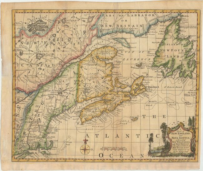
Auction 153, Lot 124
Subject: Colonial Northeastern United States & Canada
Gibson, John
A Particular Map, to Illustrate Gen. Amherst's Expedition, to Montreal; with a Plan of the Town & Draught of ye Island, 1760
Size: 9 x 7.2 inches (22.9 x 18.3 cm)
Estimate: $140 - $180
Sold for: $80
Closed on 5/20/2015

Auction 153, Lot 125
Subject: Colonial Northeastern United States & Canada
Jefferys/Sayer & Bennett
An Exact Chart of the River St. Laurence, from Fort Frontenac to the Island of Anticosti Shewing the Soundings, Rocks, Shoals, &c. with Views of the Lands and All Necessary Instructions for Navigating that River to Quebec, 1775
Size: 37.5 x 23.5 inches (95.3 x 59.7 cm)
Estimate: $700 - $850
Sold for: $500
Closed on 5/20/2015
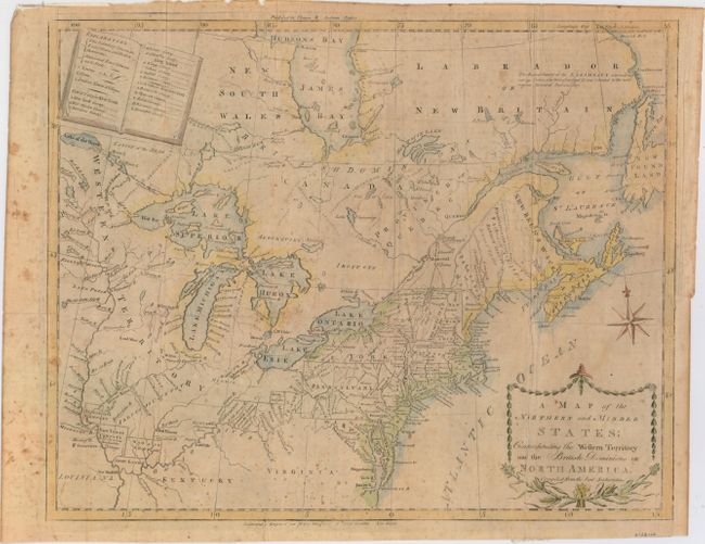
Auction 153, Lot 126
Subject: Northeastern United States & Canada
Doolittle, Amos
A Map of the Northern and Middle States: Comprehending the Western Territory and the British Dominions in North America, Compiled from the Best Authorities, 1793
Size: 16 x 12.5 inches (40.6 x 31.8 cm)
Estimate: $550 - $700
Sold for: $300
Closed on 5/20/2015
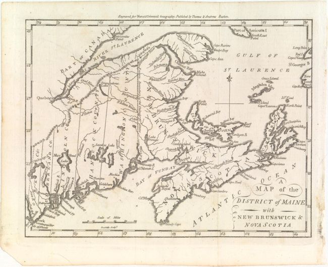
Auction 153, Lot 127
Subject: Northeastern United States & Canada
Morse, Jedidiah (Rev.)
A Map of the District of Maine with New Brunswick & Nova Scotia, 1796
Size: 9.1 x 6.9 inches (23.1 x 17.5 cm)
Estimate: $200 - $240
Unsold
Closed on 5/20/2015
Auction 153, Lot 128
Subject: Northeastern United States & Canada, Great Lakes
Robert de Vaugondy, Didier
Partie de l'Amerique Septent? qui Comprend la Nouvelle France ou le Canada, 1799
Size: 23.8 x 19.1 inches (60.5 x 48.5 cm)
Estimate: $700 - $850
Sold for: $700
Closed on 5/20/2015

Auction 153, Lot 129
Subject: Northeastern United States & Canada
Basire, James III
[Rideau Canal] Estimates. Water Communication in Canada., 1827
Size: 8 x 7 inches (20.3 x 17.8 cm)
Estimate: $140 - $170
Sold for: $110
Closed on 5/20/2015

Auction 153, Lot 130
Subject: Western United States & Canada
Imray, James
West Coast of North America from San Francisco to Queen Charlotte Ids., 1884
Size: 40 x 49.8 inches (101.6 x 126.5 cm)
Estimate: $700 - $850
Sold for: $300
Closed on 5/20/2015
33 lots