Filtered by Category:United States(Show All Categories)
Showing results for:Auction 143
Catalog Archive
164 lots
Page 1 of 4
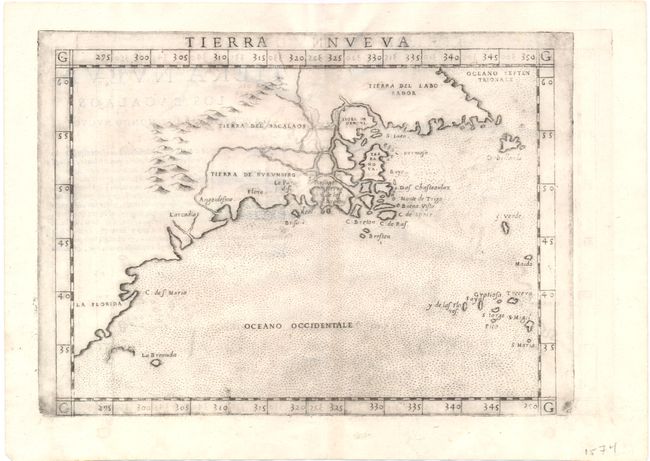
Auction 143, Lot 150
Subject: Eastern Canada & United States
Ruscelli, Girolamo
Tierra Nueva, 1574
Size: 10.3 x 7.5 inches (26.2 x 19.1 cm)
Estimate: $1,000 - $1,200
Sold for: $750
Closed on 2/13/2013
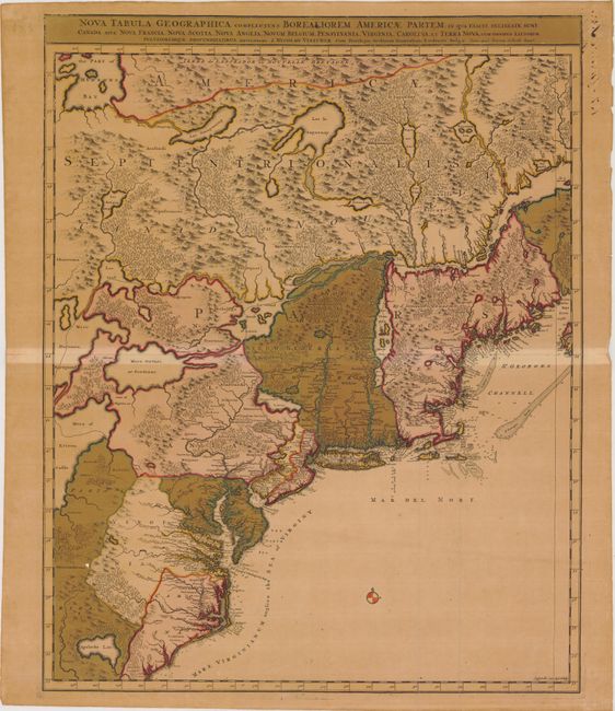
Auction 143, Lot 151
Subject: Colonial United States & Canada
Visscher/Schenk
Nova Tabula Geographica Complectens Borealiorem Americae Partem; in qua Exacte Delineatae sunt Canada sive Nova Francia, Nova Scotia, Nova Anglia, Novum Belgium, Pensylvania, Virginia, Carolina, et Terra Nova..., 1715
Size: 18.5 x 23.2 inches (47 x 58.9 cm)
Estimate: $800 - $1,000
Sold for: $600
Closed on 2/13/2013

Auction 143, Lot 152
Subject: Colonial United States & Canada
Homann Heirs
Dominia Anglorum in America Septentrionali, 1740
Size: 21.5 x 19.8 inches (54.6 x 50.3 cm)
Estimate: $550 - $700
Sold for: $325
Closed on 2/13/2013
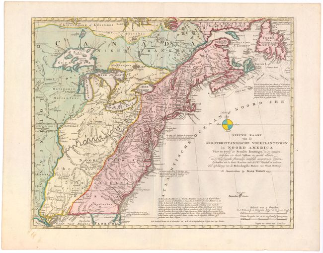
Auction 143, Lot 153
Subject: Colonial United States & Canada
Tirion, Isaac
Nieuwe Kaart van de Grootbrittannische Volkplantingen in Noord America…, 1755
Size: 18 x 14.3 inches (45.7 x 36.3 cm)
Estimate: $750 - $850
Sold for: $550
Closed on 2/13/2013
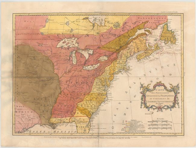
Auction 143, Lot 154
Subject: Colonial United States & Canada
Palairet, Jean
Carte des Possessions Angloises & Francoises du Continent de l'Amerique Septentrionale, 1756
Size: 22.5 x 16.7 inches (57.2 x 42.4 cm)
Estimate: $2,000 - $2,400
Sold for: $1,400
Closed on 2/13/2013

Auction 143, Lot 155
Subject: Colonial United States & Canada
Clouet, Jean Baptiste Louis
[Des Possessions Francoises Aujourd'hui sous la Domination Angloises ...], 1767
Size: 13.7 x 12.3 inches (34.8 x 31.2 cm)
Estimate: $250 - $325
Sold for: $120
Closed on 2/13/2013
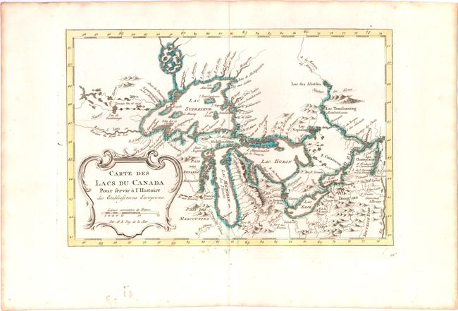
Auction 143, Lot 156
Subject: Colonial United States & Canada, Great Lakes
Bellin, Jacques Nicolas
Carte des Lacs du Canada pour Servir a l'Histoire des Etablissemens Europeens, 1773
Size: 11.2 x 7.4 inches (28.4 x 18.8 cm)
Estimate: $450 - $550
Sold for: $425
Closed on 2/13/2013

Auction 143, Lot 157
Subject: Colonial United States & Canada
D'Anville/Santini
Carte Generale du Canada, de la Louisiane, de la Floride, de la Caroline, de la Virginie, de la Nouvelle Angleterre etc. par le Sr. d'Anville, 1776
Size: 25.8 x 18.8 inches (65.5 x 47.8 cm)
Estimate: $650 - $800
Sold for: $400
Closed on 2/13/2013
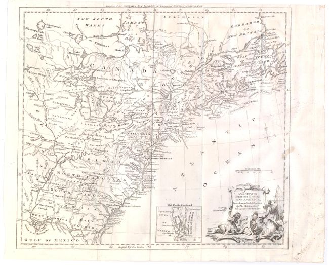
Auction 143, Lot 158
Subject: Colonial United States & Canada
Kitchin, Thomas
A New Map of the British Empire in Nth. America, Drawn from the Latest Authorities, 1782
Size: 14.9 x 13.2 inches (37.8 x 33.5 cm)
Estimate: $475 - $600
Sold for: $240
Closed on 2/13/2013
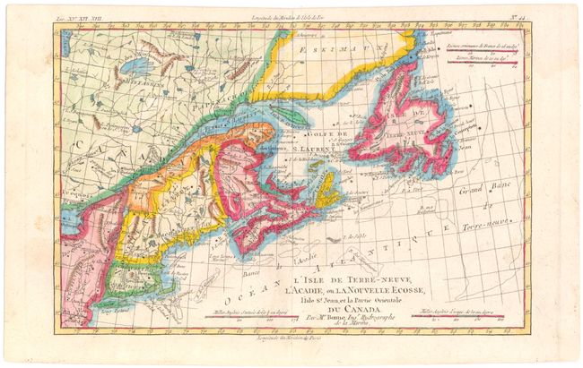
Auction 143, Lot 159
Subject: Colonial Eastern Canada, New England
Bonne/Raynal
L'Isle de Terre-Neuve, l'Acadie, ou la Nouvelle Ecosse, l'Isle St. Jean, et la Partie Orientale du Canada, 1775
Size: 12.5 x 8.2 inches (31.8 x 20.8 cm)
Estimate: $160 - $200
Sold for: $120
Closed on 2/13/2013
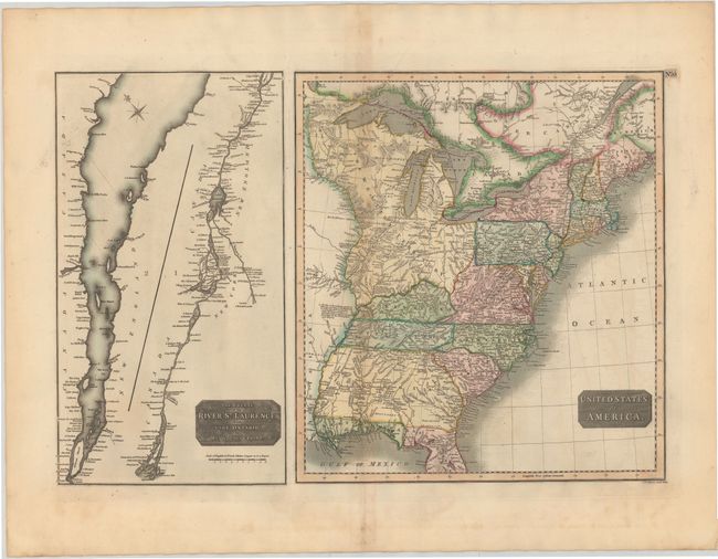
Auction 143, Lot 160
Subject: Canada & United States
Thomson, John
United States of America [on sheet with] The Course of the River St. Laurence, from Lake Ontario, to Manicouagan Point, 1814
Size: 24.5 x 16.1 inches (62.2 x 40.9 cm)
Estimate: $250 - $325
Sold for: $180
Closed on 2/13/2013
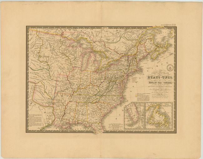
Auction 143, Lot 161
Subject: Canada & United States
Brue, Adrien Hubert
Carte Generale des Etats-Unis, des Haut et Bas-Canada…, 1832
Size: 20.3 x 14.5 inches (51.6 x 36.8 cm)
Estimate: $160 - $200
Sold for: $120
Closed on 2/13/2013
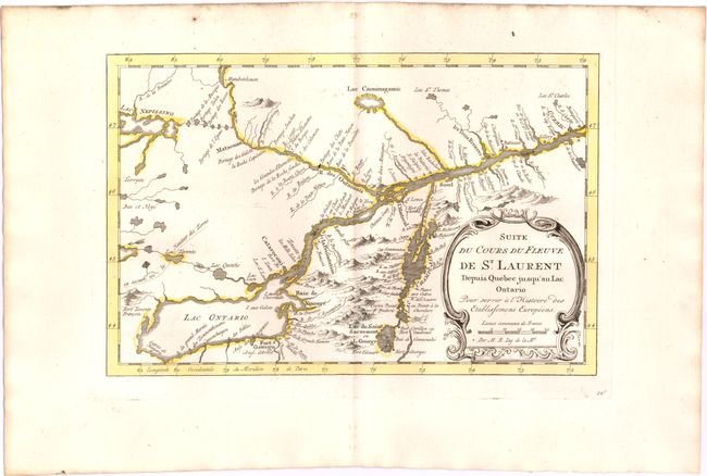
Auction 143, Lot 162
Subject: Colonial Lake Ontario & St. Lawrence River
Bellin, Jacques Nicolas
Suite du Cours du Fleuve de St. Laurent Depuis Quebec Jusqu'au Lac Ontario pour Servir a l'Histoire des Etablissemens Europeens, 1773
Size: 11 x 7.2 inches (27.9 x 18.3 cm)
Estimate: $140 - $180
Sold for: $100
Closed on 2/13/2013
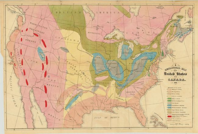
Auction 143, Lot 163
Subject: Canada & United States
Hitchcock, Edward
[Lot of 2] A Geological Map of the United States and Canada [and] Outline of the Geology of the Globe, 1853
Size: See Description
Estimate: $1,000 - $1,300
Sold for: $950
Closed on 2/13/2013

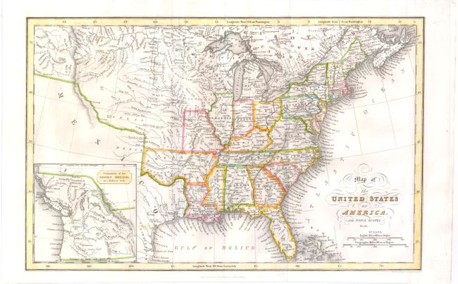
Auction 143, Lot 164
Subject: Eastern United States & Canada
Stockdale, John
A Map of the Northern & Middle States; Comprehending the Western Territory and the British Dominions in North America. From the Best Authorities, 1792
Size: 15.7 x 12.5 inches (39.9 x 31.8 cm)
Estimate: $650 - $800
Unsold
Closed on 2/13/2013
Auction 143, Lot 166
Subject: United States
Hinton, Simpkin & Marshall
Map of the United States of America and Nova Scotia, &c.&c., 1832
Size: 15.6 x 9.8 inches (39.6 x 24.9 cm)
Estimate: $200 - $250
Sold for: $150
Closed on 2/13/2013
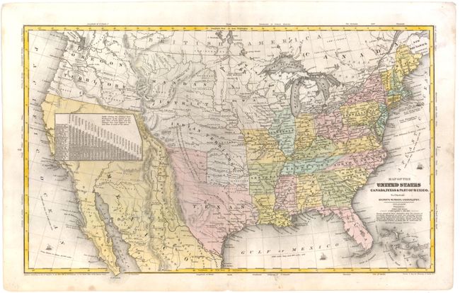
Auction 143, Lot 167
Subject: United States, Texas & Mexico
Robinson, D.F. & Co.
Map of the United States Canada, Texas & Part of Mexico to Illustrate Olney's School Geography, 1844
Size: 17.3 x 10.4 inches (43.9 x 26.4 cm)
Estimate: $230 - $300
Sold for: $150
Closed on 2/13/2013
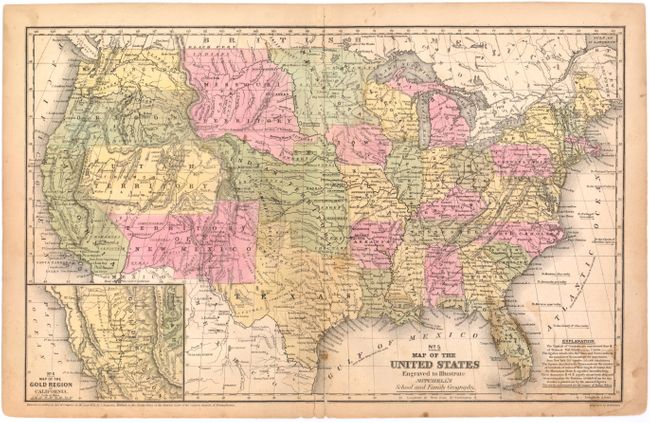
Auction 143, Lot 168
Subject: United States
Mitchell, Samuel Augustus
No. 5 Map of the United States Engraved to Illustrate Mitchell's School and Family Geography, 1852
Size: 16.7 x 10.5 inches (42.4 x 26.7 cm)
Estimate: $120 - $150
Unsold
Closed on 2/13/2013
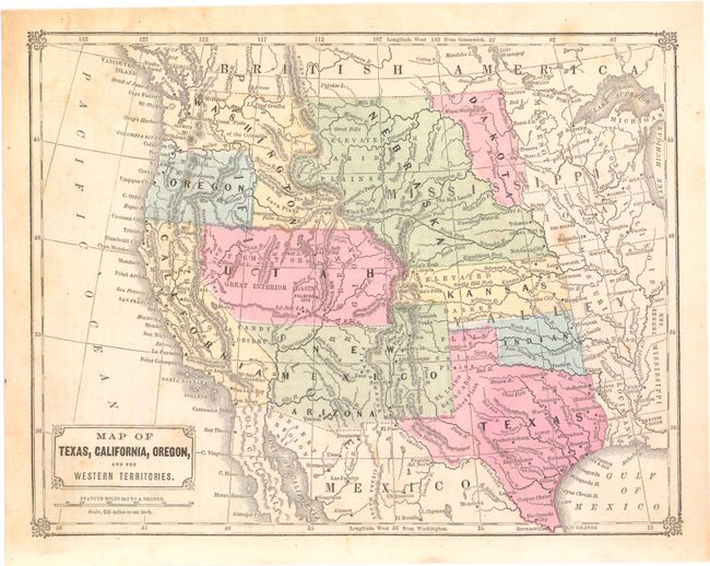
Auction 143, Lot 169
Subject: United States
[Lot of 3] Map of Texas, California, Oregon, and the Western Territories [and] Map of the United States [and] Commercial Map of the United States Showing the Principal Connecting Lines of Railroad Across the Country..., 1860
Size: See Description
Estimate: $100 - $130
Sold for: $70
Closed on 2/13/2013

Auction 143, Lot 170
Subject: United States
Johnson, A. J.
Johnson's United States, 1864
Size: 23.2 x 17 inches (58.9 x 43.2 cm)
Estimate: $80 - $100
Sold for: $55
Closed on 2/13/2013
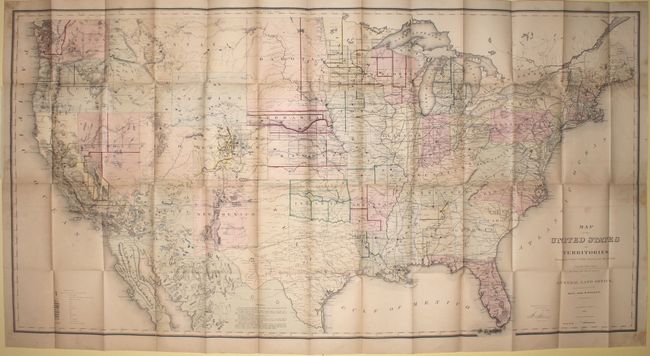
Auction 143, Lot 171
Subject: United States
General Land Office
Map of the United States and Territories, Showing the Extent of Public Surveys and Other Details, 1868
Size: 55 x 28 inches (139.7 x 71.1 cm)
Estimate: $450 - $600
Sold for: $230
Closed on 2/13/2013
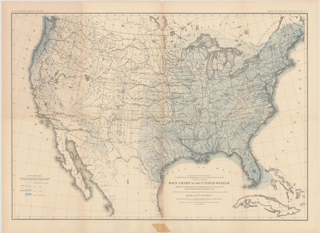
Auction 143, Lot 172
Subject: United States
Powell, John Wesley
Rain Chart of the United States Showing by Isohyetal Lines the Distribution of the Mean Annual Precipitation in Rain and Melted Snow, 1878
Size: 28.4 x 19.6 inches (72.1 x 49.8 cm)
Estimate: $80 - $120
Sold for: $170
Closed on 2/13/2013
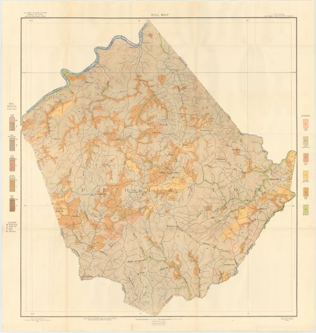
Auction 143, Lot 173
Subject: United States
U.S.D.A.
[Lot of 53 - U.S.D.A. Soil Maps], 1904
Size: 10 x 6 inches (25.4 x 15.2 cm)
Estimate: $700 - $900
Sold for: $350
Closed on 2/13/2013

Auction 143, Lot 174
Subject: United States
Automobile Club of Southern California
[Lot of 48] Automobile Road from New York to Los Angeles via National Old Trails Road and its Principle Tributaries, 1915-17
Size: 8.5 x 2.8 inches (21.6 x 7.1 cm)
Estimate: $200 - $250
Sold for: $550
Closed on 2/13/2013

Auction 143, Lot 175
Subject: United States
[Lot of 2] A Good-Natured Map of the United States Setting Forth the Services of the Greyhound Lines and a Few Principal Connecting Bus Lines [with brochure size], 1937-39
Size: 29 x 19.1 inches (73.7 x 48.5 cm)
Estimate: $350 - $450
Sold for: $250
Closed on 2/13/2013
Auction 143, Lot 176
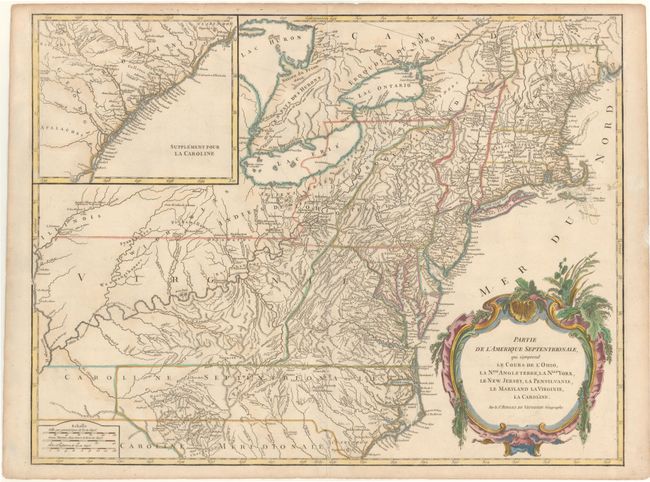
Subject: Colonial Eastern United States
Robert de Vaugondy
Partie de l'Amerique Septentrionale, qui Comprend le Cours De l'Ohio, la Nlle. Angleterre, la Nlle. York, le New Jersey, la Pensylvanie, le Maryland la Virginie, la Caroline., 1755
Size: 24.5 x 19 inches (62.2 x 48.3 cm)
Estimate: $800 - $1,000
Unsold
Closed on 2/13/2013
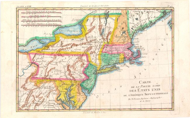
Auction 143, Lot 177
Subject: Colonial New England & Mid-Atlantic
Bonne/Raynal
Carte de la Partie Nord des Etats Unis de l'Amerique Septentrionale, 1780
Size: 12.5 x 8.2 inches (31.8 x 20.8 cm)
Estimate: $120 - $160
Sold for: $70
Closed on 2/13/2013

Auction 143, Lot 178
Subject: Eastern United States
Lopez de Vargas Machuca, Thomas (don)
Estados Unidos de la America Septenl. Parte de la Floriday el Canada, 1792
Size: 7.1 x 9.6 inches (18 x 24.4 cm)
Estimate: $240 - $300
Sold for: $180
Closed on 2/13/2013
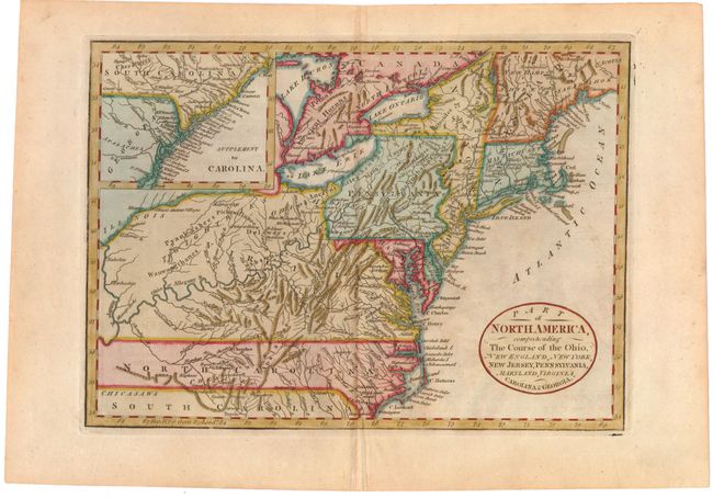
Auction 143, Lot 179
Subject: Eastern United States
Cary, John
Part of North America, Comprehending the Course of the Ohio, New England, New York, New Jersey, Pennsylvania, Maryland, Virginia, Carolina & Georgia, 1795
Size: 11.6 x 8.3 inches (29.5 x 21.1 cm)
Estimate: $300 - $400
Sold for: $300
Closed on 2/13/2013
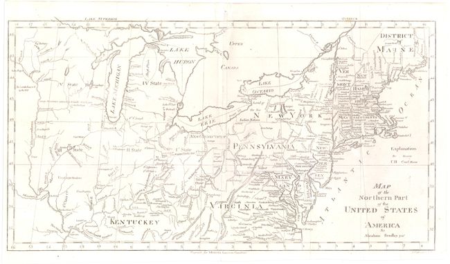
Auction 143, Lot 180
Subject: Eastern United States
Bradley, Abraham Jr.
Map of the Northern Part of the United States of America, 1797
Size: 15.7 x 8.4 inches (39.9 x 21.3 cm)
Estimate: $230 - $275
Sold for: $170
Closed on 2/13/2013
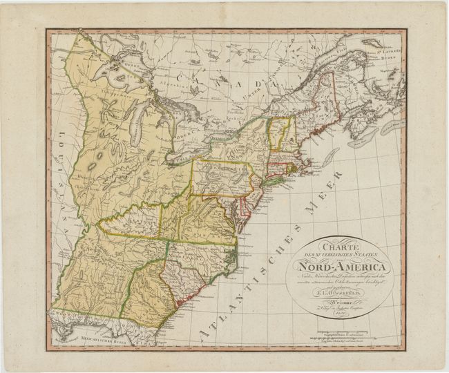
Auction 143, Lot 181
Subject: Eastern United States, Franklinia
Gussefeld, Franz Ludwig
Charte der XV Vereinigten Staaten von Nord-America…, 1800
Size: 20.5 x 18.3 inches (52.1 x 46.5 cm)
Estimate: $1,400 - $1,600
Map Depicting the Proposed State of Franklin
Sold for: $2,500
Closed on 2/13/2013
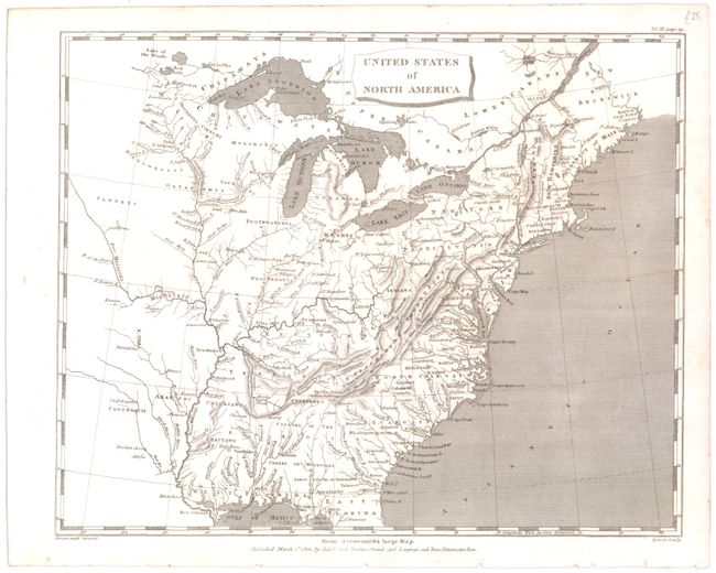
Auction 143, Lot 182
Subject: Eastern United States
Arrowsmith, Aaron, Sr.
United States of North America, 1802
Size: 9.8 x 7.8 inches (24.9 x 19.8 cm)
Estimate: $180 - $220
Sold for: $90
Closed on 2/13/2013

Auction 143, Lot 183
Subject: Eastern United States
Pinkerton, John
United States of America Northern Part, 1810
Size: 27.5 x 19.8 inches (69.9 x 50.3 cm)
Estimate: $300 - $375
Unsold
Closed on 2/13/2013
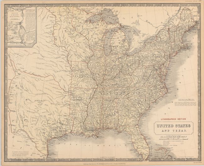
Auction 143, Lot 184
Subject: Eastern United States
Johnston, W. & A.K.
United States and Texas, 1844
Size: 24.7 x 19.8 inches (62.7 x 50.3 cm)
Estimate: $1,000 - $1,200
Sold for: $800
Closed on 2/13/2013
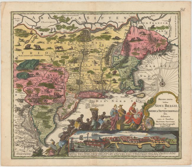
Auction 143, Lot 185
Subject: Colonial New England & Mid-Atlantic
Seutter, Matthias
Recens Edita totius Novi Belgii, in America Septentrionali siti, delineatio cura et Sumtibus, 1730
Size: 22.5 x 19.5 inches (57.2 x 49.5 cm)
Estimate: $4,000 - $4,750
Sold for: $3,250
Closed on 2/13/2013
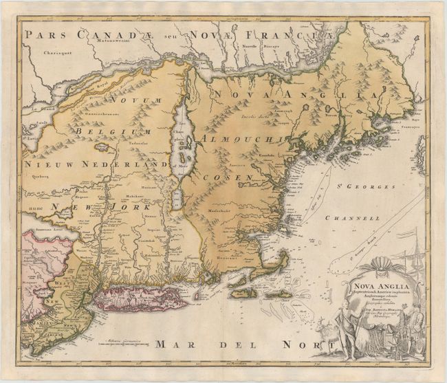
Auction 143, Lot 186
Subject: Colonial New England & Mid-Atlantic
Homann, Johann Baptist
Nova Anglia Septentrionali Americae Implantata Anglorumque Coloniis Florentissima, 1730
Size: 22.3 x 19 inches (56.6 x 48.3 cm)
Estimate: $1,500 - $1,700
Sold for: $850
Closed on 2/13/2013
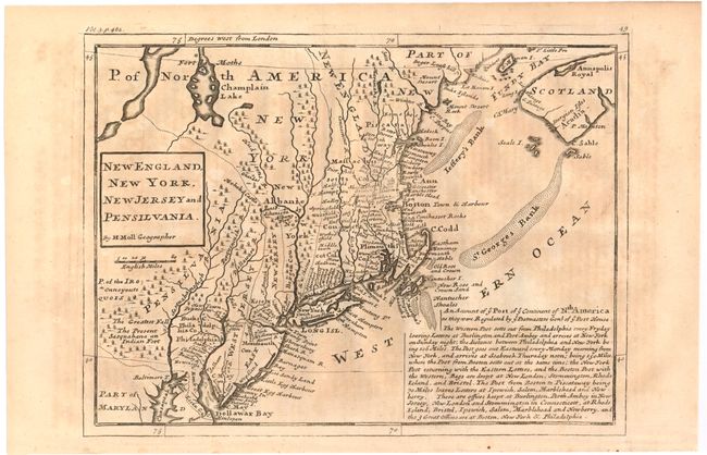
Auction 143, Lot 187
Subject: Colonial New England & Mid-Atlantic
Moll, Herman
New England, New York, New Jersey and Pensilvania, 1740
Size: 10.8 x 8 inches (27.4 x 20.3 cm)
Estimate: $450 - $550
Sold for: $200
Closed on 2/13/2013
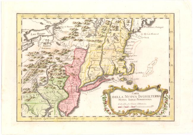
Auction 143, Lot 188
Subject: Colonial New England & Mid-Atlantic
Bellin, Jacques Nicolas
Carta della Nuova Inghilterra Nuova Iork, e Pensilvania, 1777
Size: 11.7 x 8.1 inches (29.7 x 20.6 cm)
Estimate: $300 - $400
Sold for: $150
Closed on 2/13/2013

Auction 143, Lot 189
Subject: New England
Russell, John C.
Map of the Northern, or, New England States of America, Comprehending Vermont, New Hampshire, District of Main, Massachusetts, Rhode Island, and Connecticut, 1795
Size: 18.3 x 14.3 inches (46.5 x 36.3 cm)
Estimate: $325 - $400
Sold for: $400
Closed on 2/13/2013
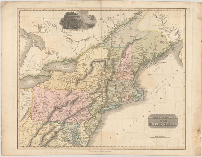
Auction 143, Lot 190
Subject: New England & Mid-Atlantic
Thomson, John
Northern Provinces of the United States, 1817
Size: 23.5 x 19.5 inches (59.7 x 49.5 cm)
Estimate: $300 - $375
Sold for: $300
Closed on 2/13/2013
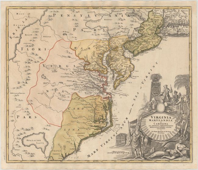
Auction 143, Lot 191
Subject: Colonial Mid-Atlantic
Homann, Johann Baptist
Virginia Marylandia et Carolina in America Septentrionali Britannorum Industria Excultae, 1730
Size: 22.8 x 19.2 inches (57.9 x 48.8 cm)
Estimate: $1,900 - $2,200
Sold for: $1,000
Closed on 2/13/2013
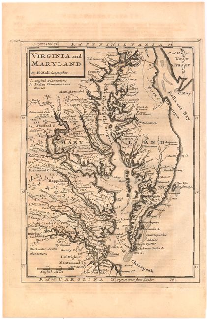
Auction 143, Lot 192
Subject: Colonial Mid-Atlantic
Moll, Herman
Virginia and Maryland, 1740
Size: 8 x 10.7 inches (20.3 x 27.2 cm)
Estimate: $500 - $650
Sold for: $475
Closed on 2/13/2013

Auction 143, Lot 193
Subject: Colonial Mid-Atlantic
Homann Heirs
Mappa Geographica Provinciae novae Eboraci ab Anglis New-York …Nova Jersey…, 1778
Size: 22.4 x 27.8 inches (56.9 x 70.6 cm)
Estimate: $1,400 - $1,700
Unsold
Closed on 2/13/2013
Auction 143, Lot 194
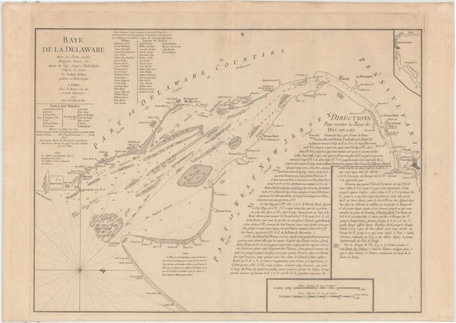
Subject: Colonial Mid-Atlantic, Delaware Bay
Le Rouge, George Louis
Baye de la Delaware avec les Ports, Sondes, Dangers, Bancs &c. depuis les Caps Jusqu'a Philadelphie…, 1777
Size: 25.8 x 19 inches (65.5 x 48.3 cm)
Estimate: $2,000 - $2,400
The Most Accurate Chart of Delaware Bay in the 18th Century
Unsold
Closed on 2/13/2013
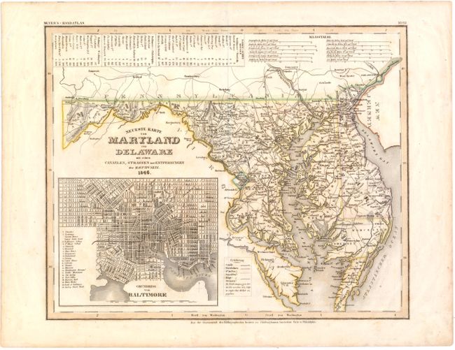
Auction 143, Lot 195
Subject: Mid-Atlantic, Maryland & Delaware
Meyer, Joseph
Neueste Karte von Maryland und Delaware mit seinen Canaelen, Strassen und Entfernungen der Hauptpunkte, 1846
Size: 14.6 x 11.8 inches (37.1 x 30 cm)
Estimate: $160 - $200
Sold for: $120
Closed on 2/13/2013
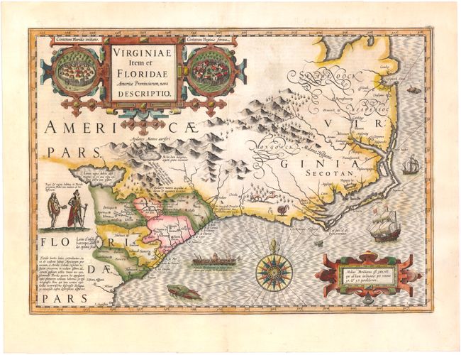
Auction 143, Lot 196
Subject: Colonial Southeast
Hondius, Jodocus
Virginiae Item et Floridae Americae Provinciarum, Nova Descriptio, 1628
Size: 19.1 x 13.5 inches (48.5 x 34.3 cm)
Estimate: $2,400 - $3,000
A Seminal Map of the Southeast and Early American Cartography
Sold for: $2,000
Closed on 2/13/2013
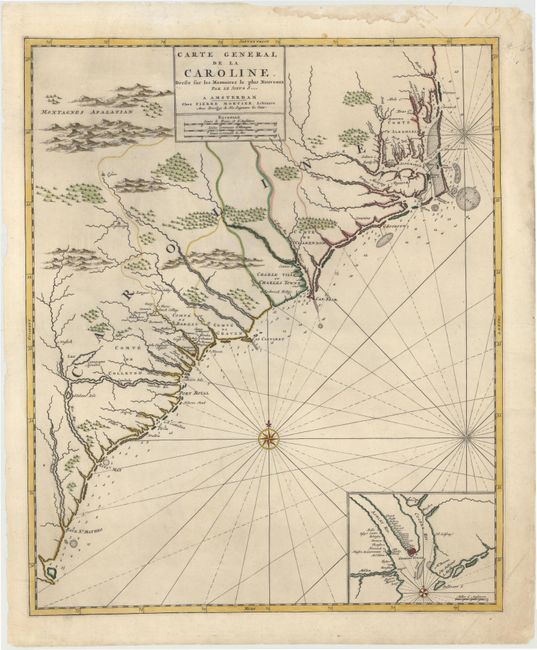
Auction 143, Lot 197
Subject: Colonial Southeast, North Carolina, South Carolina
Mortier, Pierre
Carte General de la Caroline Dresse sur les Memoires le Plus Nouveaux..., 1700
Size: 18.3 x 22.2 inches (46.5 x 56.4 cm)
Estimate: $3,250 - $4,000
Sold for: $2,100
Closed on 2/13/2013
Auction 143, Lot 198
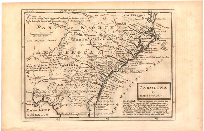
Subject: Colonial Southeast, North Carolina, South Carolina
Moll, Herman
Carolina, 1740
Size: 10.8 x 8 inches (27.4 x 20.3 cm)
Estimate: $600 - $750
Sold for: $300
Closed on 2/13/2013
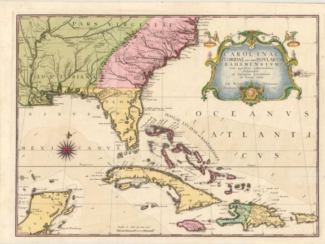
Auction 143, Lot 199
Subject: Colonial Southeast & Bahamas
Seligmann, Johann Michael
Carolinae Floridae nec non Insularum Bahamensium…, 1755
Size: 23 x 16.8 inches (58.4 x 42.7 cm)
Estimate: $5,500 - $6,500
Very Scarce and Important Map of the Southeastern United States
Sold for: $3,750
Closed on 2/13/2013
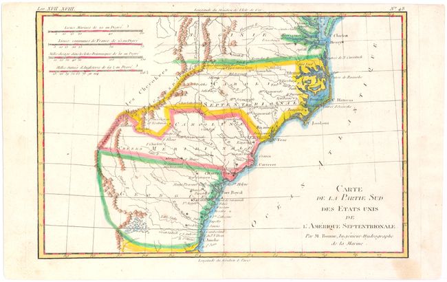
Auction 143, Lot 200
Subject: Colonial Southeast
Bonne, Rigobert
Carte de la Partie Sud des Etats Unis de l'Amerique Septentrionale, 1780
Size: 12.5 x 8.3 inches (31.8 x 21.1 cm)
Estimate: $140 - $180
Sold for: $150
Closed on 2/13/2013
164 lots
Page 1 of 4