Filtered by Category:Canada(Show All Categories)
Showing results for:Auction 143
Catalog Archive
23 lots
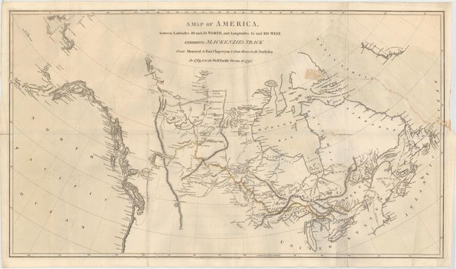
Auction 143, Lot 142
Subject: Canada
Mackenzie, Alexander
A Map of America, from Latitudes 40 and 70 North, and Longitudes 45 and 180 West, Exhibiting Mackenzie's Track from Montreal to Fort Chipewyan & from Thence to the North Sea in 1789, & to the West Pacific Ocean in 1793, 1801
Size: 11 x 7 inches (27.9 x 17.8 cm)
Estimate: $450 - $550
Sold for: $300
Closed on 2/13/2013

Auction 143, Lot 143
Subject: Halifax, Canada
A Plan of the Harbour of Chebucto and Town of Halifax, 1750
Size: 10.8 x 8.8 inches (27.4 x 22.4 cm)
Estimate: $700 - $850
The Porcupine Map
Unsold
Closed on 2/13/2013
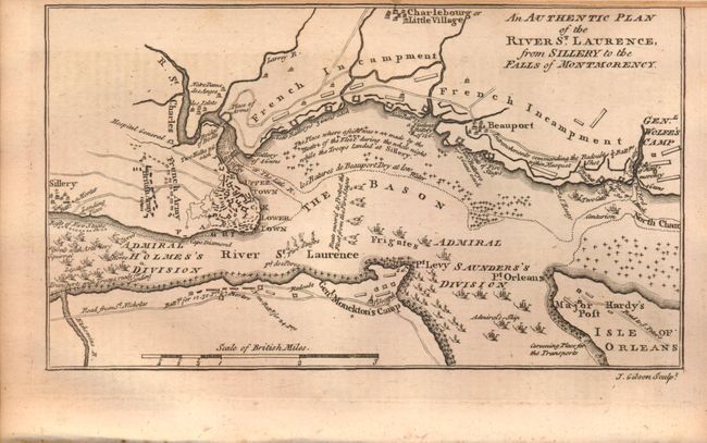
Auction 143, Lot 144
Subject: Quebec, Canada
[Lot of 3] An Authentic Plan of the River St. Laurence, from Sillery to the Falls of Montmorency [and] A Map of the Island of Orleans with the Environs of Quebec [and] Grundriss der Stadt Quebec, 1759-60
Size: See Description
Estimate: $350 - $450
Sold for: $150
Closed on 2/13/2013
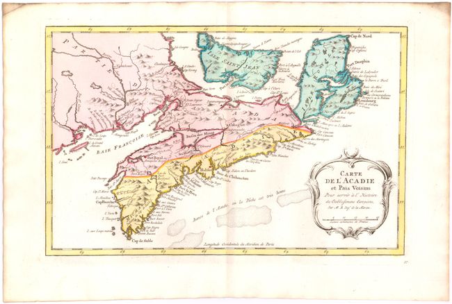
Auction 143, Lot 145
Subject: Canadian Maritimes
Bellin, Jacques Nicolas
Carte de l'Acadie et Pais Voisins pour Servir a l'Histoire des Etablissemens Europeens, 1773
Size: 12.7 x 8 inches (32.3 x 20.3 cm)
Estimate: $200 - $240
Sold for: $190
Closed on 2/13/2013
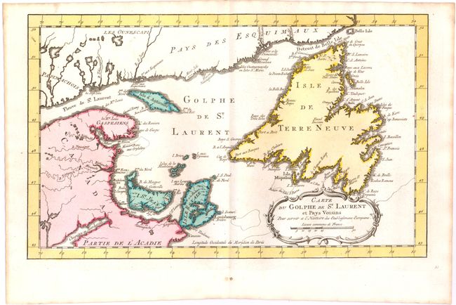
Auction 143, Lot 146
Subject: St. Lawrence Bay, Canada
Bellin, Jacques Nicolas
Carte du Golphe de St. Laurent et Pays Voisins pour Servir a l'Histoire des Etablissemens Europeens, 1773
Size: 14 x 8.5 inches (35.6 x 21.6 cm)
Estimate: $140 - $180
Sold for: $75
Closed on 2/13/2013
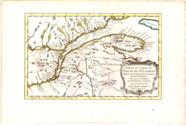
Auction 143, Lot 147
Subject: St. Lawrence River, Canada
Bellin, Jacques Nicolas
Carte du Cours du Fleuve de St. Laurent Depuis son Embouchure Jusqu'au Dessus de Quebec pour Servir a l'Histoire des Etablissemens Europeens, 1773
Size: 11.6 x 7.3 inches (29.5 x 18.5 cm)
Estimate: $140 - $180
Sold for: $100
Closed on 2/13/2013
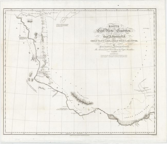
Auction 143, Lot 148
Subject: Canadian Arctic
Murray, John
Route of the Land Arctic Expedition, Under the Command of Captn. J. Franklin R N. from Great Slave Lake to Great Bear Lake River..., 1828
Size: 23 x 19 inches (58.4 x 48.3 cm)
Estimate: $240 - $300
Sold for: $200
Closed on 2/13/2013

Auction 143, Lot 149
Subject: Canso Harbor, Nova Scotia, Canada
British Admiralty
Nova Scotia Canso Harbour, 1853
Size: 25 x 18.9 inches (63.5 x 48 cm)
Estimate: $190 - $220
Unsold
Closed on 2/13/2013
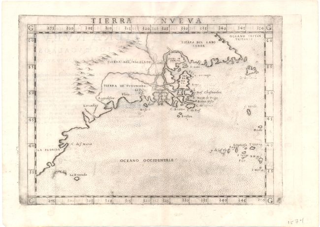
Auction 143, Lot 150
Subject: Eastern Canada & United States
Ruscelli, Girolamo
Tierra Nueva, 1574
Size: 10.3 x 7.5 inches (26.2 x 19.1 cm)
Estimate: $1,000 - $1,200
Sold for: $750
Closed on 2/13/2013
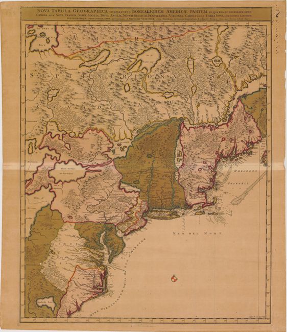
Auction 143, Lot 151
Subject: Colonial United States & Canada
Visscher/Schenk
Nova Tabula Geographica Complectens Borealiorem Americae Partem; in qua Exacte Delineatae sunt Canada sive Nova Francia, Nova Scotia, Nova Anglia, Novum Belgium, Pensylvania, Virginia, Carolina, et Terra Nova..., 1715
Size: 18.5 x 23.2 inches (47 x 58.9 cm)
Estimate: $800 - $1,000
Sold for: $600
Closed on 2/13/2013

Auction 143, Lot 152
Subject: Colonial United States & Canada
Homann Heirs
Dominia Anglorum in America Septentrionali, 1740
Size: 21.5 x 19.8 inches (54.6 x 50.3 cm)
Estimate: $550 - $700
Sold for: $325
Closed on 2/13/2013
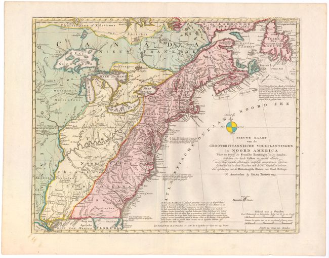
Auction 143, Lot 153
Subject: Colonial United States & Canada
Tirion, Isaac
Nieuwe Kaart van de Grootbrittannische Volkplantingen in Noord America…, 1755
Size: 18 x 14.3 inches (45.7 x 36.3 cm)
Estimate: $750 - $850
Sold for: $550
Closed on 2/13/2013
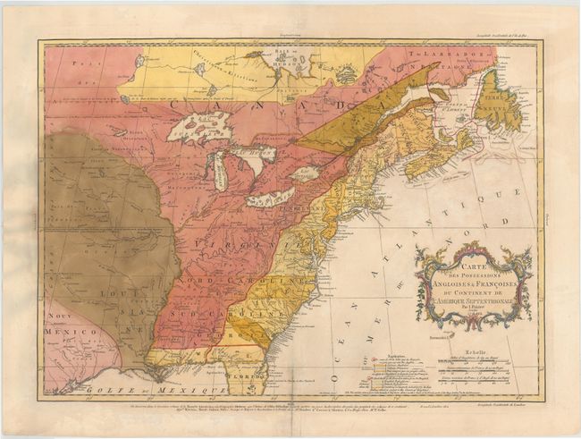
Auction 143, Lot 154
Subject: Colonial United States & Canada
Palairet, Jean
Carte des Possessions Angloises & Francoises du Continent de l'Amerique Septentrionale, 1756
Size: 22.5 x 16.7 inches (57.2 x 42.4 cm)
Estimate: $2,000 - $2,400
Sold for: $1,400
Closed on 2/13/2013

Auction 143, Lot 155
Subject: Colonial United States & Canada
Clouet, Jean Baptiste Louis
[Des Possessions Francoises Aujourd'hui sous la Domination Angloises ...], 1767
Size: 13.7 x 12.3 inches (34.8 x 31.2 cm)
Estimate: $250 - $325
Sold for: $120
Closed on 2/13/2013
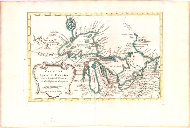
Auction 143, Lot 156
Subject: Colonial United States & Canada, Great Lakes
Bellin, Jacques Nicolas
Carte des Lacs du Canada pour Servir a l'Histoire des Etablissemens Europeens, 1773
Size: 11.2 x 7.4 inches (28.4 x 18.8 cm)
Estimate: $450 - $550
Sold for: $425
Closed on 2/13/2013

Auction 143, Lot 157
Subject: Colonial United States & Canada
D'Anville/Santini
Carte Generale du Canada, de la Louisiane, de la Floride, de la Caroline, de la Virginie, de la Nouvelle Angleterre etc. par le Sr. d'Anville, 1776
Size: 25.8 x 18.8 inches (65.5 x 47.8 cm)
Estimate: $650 - $800
Sold for: $400
Closed on 2/13/2013
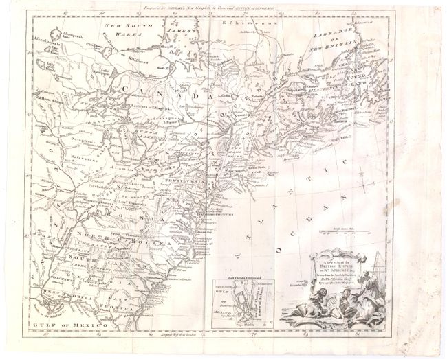
Auction 143, Lot 158
Subject: Colonial United States & Canada
Kitchin, Thomas
A New Map of the British Empire in Nth. America, Drawn from the Latest Authorities, 1782
Size: 14.9 x 13.2 inches (37.8 x 33.5 cm)
Estimate: $475 - $600
Sold for: $240
Closed on 2/13/2013
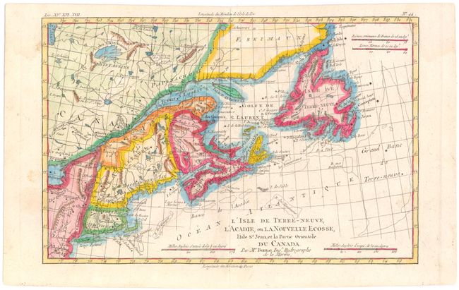
Auction 143, Lot 159
Subject: Colonial Eastern Canada, New England
Bonne/Raynal
L'Isle de Terre-Neuve, l'Acadie, ou la Nouvelle Ecosse, l'Isle St. Jean, et la Partie Orientale du Canada, 1775
Size: 12.5 x 8.2 inches (31.8 x 20.8 cm)
Estimate: $160 - $200
Sold for: $120
Closed on 2/13/2013
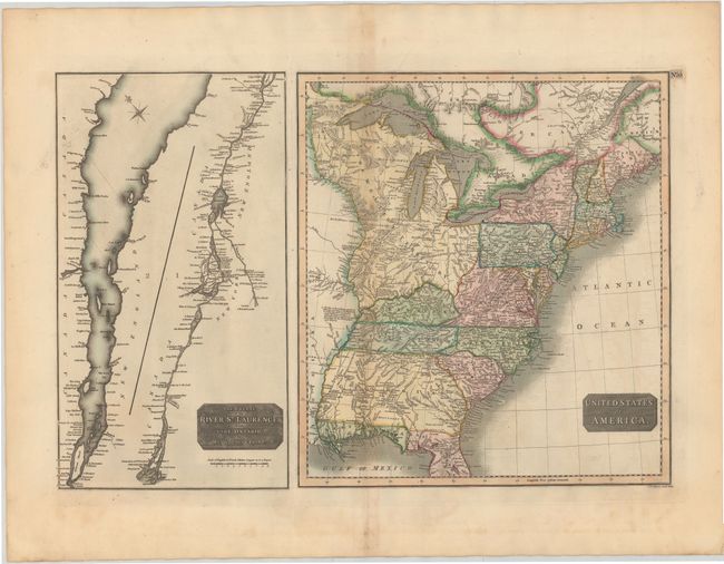
Auction 143, Lot 160
Subject: Canada & United States
Thomson, John
United States of America [on sheet with] The Course of the River St. Laurence, from Lake Ontario, to Manicouagan Point, 1814
Size: 24.5 x 16.1 inches (62.2 x 40.9 cm)
Estimate: $250 - $325
Sold for: $180
Closed on 2/13/2013
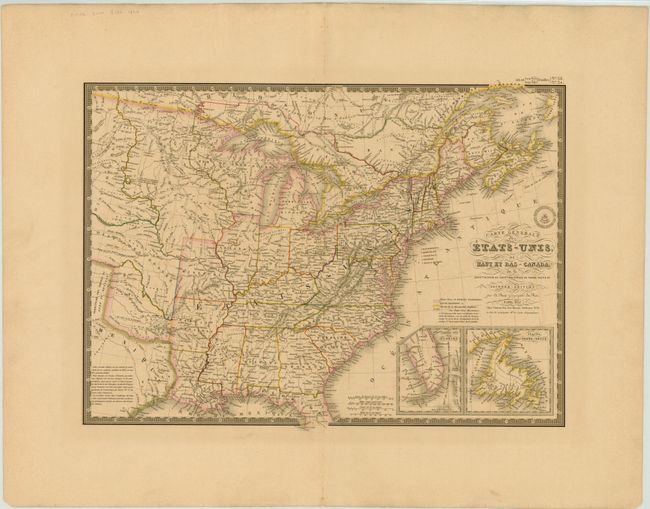
Auction 143, Lot 161
Subject: Canada & United States
Brue, Adrien Hubert
Carte Generale des Etats-Unis, des Haut et Bas-Canada…, 1832
Size: 20.3 x 14.5 inches (51.6 x 36.8 cm)
Estimate: $160 - $200
Sold for: $120
Closed on 2/13/2013
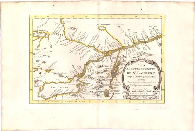
Auction 143, Lot 162
Subject: Colonial Lake Ontario & St. Lawrence River
Bellin, Jacques Nicolas
Suite du Cours du Fleuve de St. Laurent Depuis Quebec Jusqu'au Lac Ontario pour Servir a l'Histoire des Etablissemens Europeens, 1773
Size: 11 x 7.2 inches (27.9 x 18.3 cm)
Estimate: $140 - $180
Sold for: $100
Closed on 2/13/2013
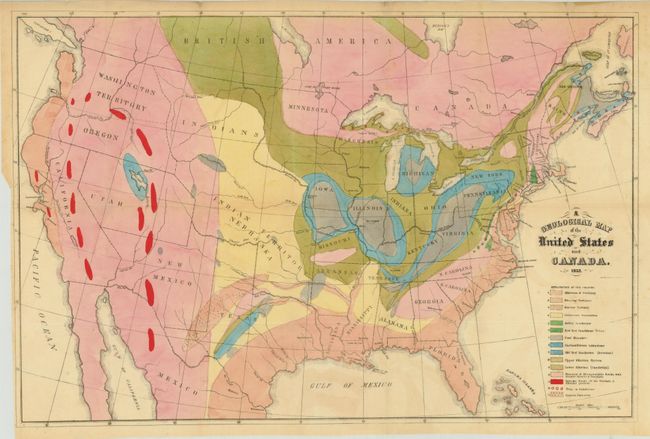
Auction 143, Lot 163
Subject: Canada & United States
Hitchcock, Edward
[Lot of 2] A Geological Map of the United States and Canada [and] Outline of the Geology of the Globe, 1853
Size: See Description
Estimate: $1,000 - $1,300
Sold for: $950
Closed on 2/13/2013

Auction 143, Lot 164
Subject: Eastern United States & Canada
Stockdale, John
A Map of the Northern & Middle States; Comprehending the Western Territory and the British Dominions in North America. From the Best Authorities, 1792
Size: 15.7 x 12.5 inches (39.9 x 31.8 cm)
Estimate: $650 - $800
Unsold
Closed on 2/13/2013
23 lots