Filtered by Category:Canada(Show All Categories)
Showing results for:Auction 135
Catalog Archive
35 lots
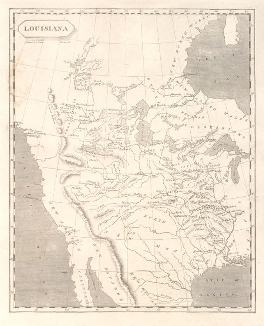
Auction 135, Lot 111
Subject: Western North America
Arrowsmith & Lewis
Louisiana, 1804
Size: 8 x 10 inches (20.3 x 25.4 cm)
Estimate: $600 - $800
Sold for: $475
Closed on 2/16/2011
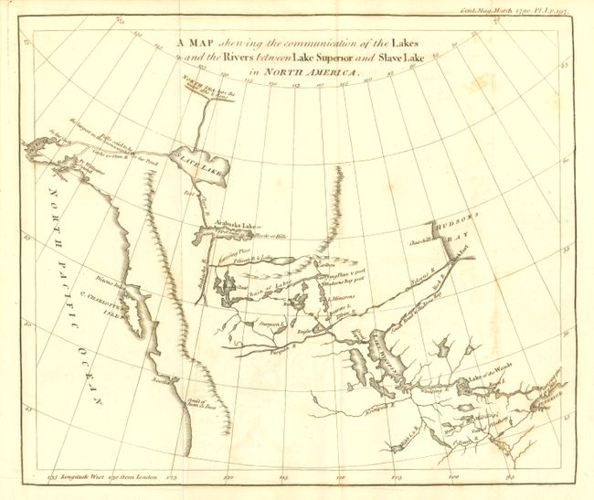
Auction 135, Lot 112
Subject: Western Canada and Alaska
Anon.
A Map Shewing the Communication of the Lakes and the Rivers between Lake Superior and Slave Lake in North America, 1790
Size: 9.25 x 7.8 inches (23.5 x 19.8 cm)
Estimate: $180 - $220
Sold for: $300
Closed on 2/16/2011
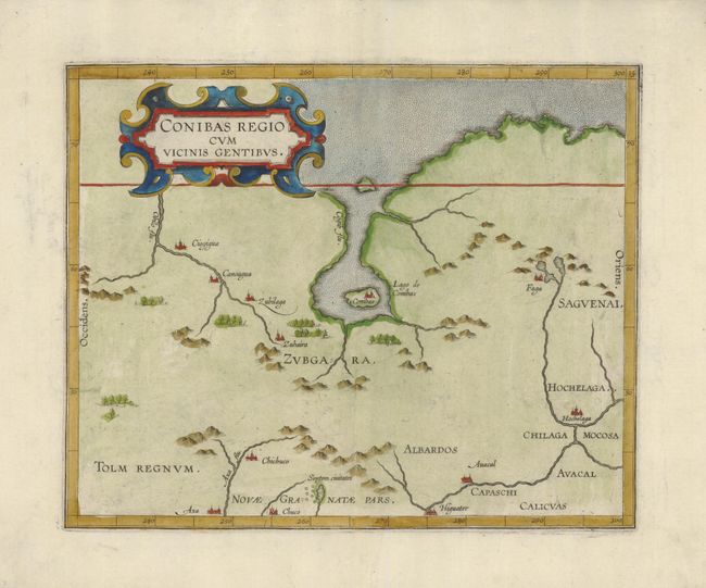
Auction 135, Lot 113
Subject: Central Canada
Wytfliet, Cornelis
Conibas Regio cum Vicinis Gentibus, 1597
Size: 10.5 x 8.5 inches (26.7 x 21.6 cm)
Estimate: $850 - $1,000
Sold for: $700
Closed on 2/16/2011
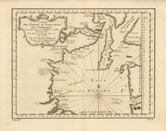
Auction 135, Lot 114
Subject: Canada - Hudson Bay
Bellin, Jacques Nicolas
Carte des Parties du Nord-Ouest de l'Amerique, 1753
Size: 10.8 x 8.2 inches (27.4 x 20.8 cm)
Estimate: $180 - $220
Sold for: $95
Closed on 2/16/2011
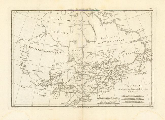
Auction 135, Lot 115
Subject: Canada
Bonne, Rigobert
Canada, 1787-88
Size: 13.5 x 9.3 inches (34.3 x 23.6 cm)
Estimate: $140 - $180
Sold for: $85
Closed on 2/16/2011
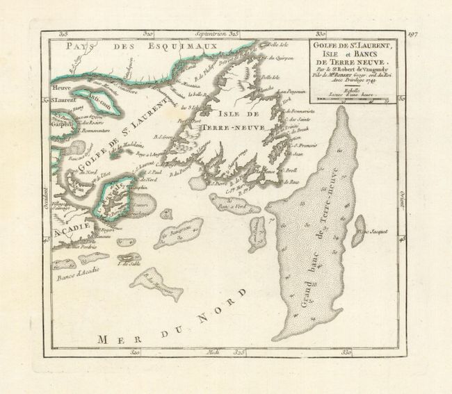
Auction 135, Lot 116
Subject: Canada
Robert de Vaugondy
Golfe de St. Laurent, Isle et Bancs de Terre Neuve, 1749
Size: 7.2 x 6.4 inches (18.3 x 16.3 cm)
Estimate: $160 - $200
Sold for: $120
Closed on 2/16/2011
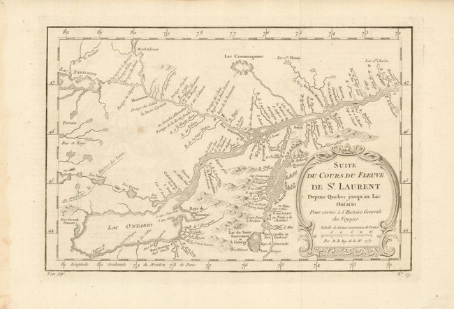
Auction 135, Lot 117
Subject: Canada
Bellin, Jacques Nicolas
Suite du Cours du Fleuve de St. Laurent Depuis Quebec jusqu'au Lac Ontario, 1757
Size: 11.3 x 7.5 inches (28.7 x 19.1 cm)
Estimate: $160 - $200
Sold for: $70
Closed on 2/16/2011

Auction 135, Lot 118
Subject: Canada
Bellin, Jacques Nicolas
Carte du Cours du Fleuve de St. Laurent Depuis son Embouchure jusqu'au dessus de Quebec, 1757
Size: 12 x 7.7 inches (30.5 x 19.6 cm)
Estimate: $140 - $180
Sold for: $90
Closed on 2/16/2011
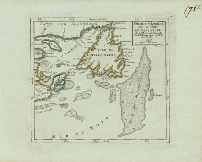
Auction 135, Lot 119
Subject: Canada
Robert de Vaugondy
[Lot of 4] Golfe de St. Laurent, Isle et Bancs de Terre Neuve [and] Partie du Canada ou se trouvent le Fleuve St. Laurent et la Nouvelle Ecosse [and] Isle Royale [and] Bayes d'Hudson et de Baffins et Terre de Labrador, 1760
Size: 7 x 6.5 inches (17.8 x 16.5 cm)
Estimate: $250 - $350
Sold for: $190
Closed on 2/16/2011
Auction 135, Lot 120
Subject: Canada
Bellin, Jacques Nicolas
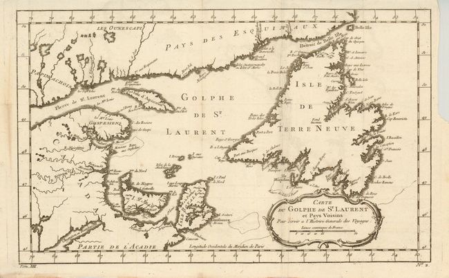
Carte du Golphe de St. Laurent et Pays Voisins, 1760
Size: 14.2 x 8.6 inches (36.1 x 21.8 cm)
Estimate: $150 - $200
Sold for: $85
Closed on 2/16/2011
Auction 135, Lot 121
Subject: Canada
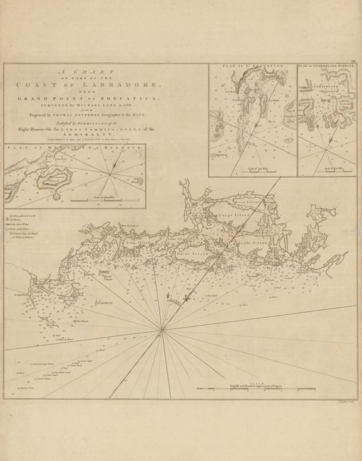
Jefferys, Thomas
A Chart of Part of the Coast of Labradore, from Grand Point to Shecatica, 1770
Size: 20.5 x 19.4 inches (52.1 x 49.3 cm)
Estimate: $275 - $325
Sold for: $375
Closed on 2/16/2011
Auction 135, Lot 122
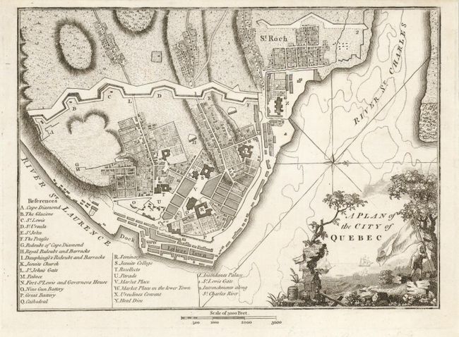
Subject: Quebec, Canada
Weld, Isaac
A Plan of the City of Quebec, 1795
Size: 9.4 x 6.6 inches (23.9 x 16.8 cm)
Estimate: $250 - $300
Sold for: $130
Closed on 2/16/2011
Auction 135, Lot 123
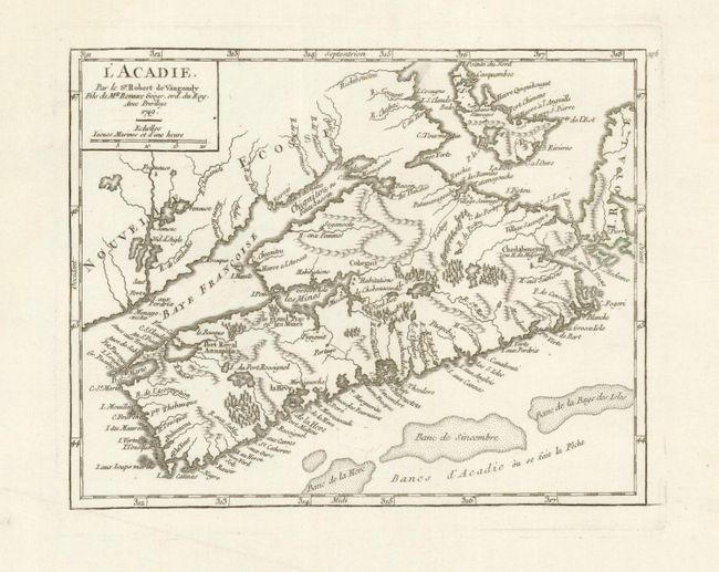
Subject: Canadian Maritimes
Robert de Vaugondy
L'Acadie, 1749
Size: 8 x 6.3 inches (20.3 x 16 cm)
Estimate: $180 - $220
Sold for: $140
Closed on 2/16/2011
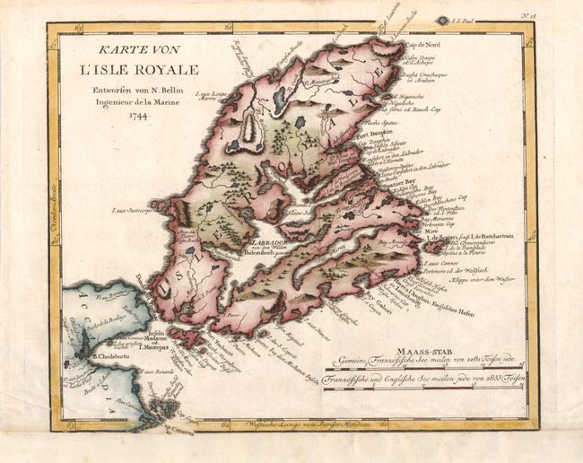
Auction 135, Lot 124
Subject: Canadian Maritimes
Bellin, Jacques Nicolas
Karte von l'Isle Royale Entworfen, 1756
Size: 10.5 x 9.3 inches (26.7 x 23.6 cm)
Estimate: $140 - $180
Sold for: $100
Closed on 2/16/2011
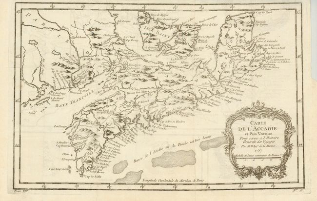
Auction 135, Lot 125
Subject: Canadian Maritimes
Bellin, Jacques Nicolas
Carte de l'Acadie et Pais Voisins…, 1757
Size: 13 x 8.3 inches (33 x 21.1 cm)
Estimate: $160 - $200
Sold for: $160
Closed on 2/16/2011
Auction 135, Lot 126
Subject: Colonial Canada & United States, Exploration
Lahontan, Louis Armand, Baron de
[Lot of 2] Nouveaux Voyages de Mr le Baron de Lahontan, dans l'Amerique Septentrionale… Tome Premier … 1704 [and] Memoires de l'Amerique Septentrionale … Tome Second … 1703, 1703-1704
Size: 4 x 6.5 inches (10.2 x 16.5 cm)
Estimate: $2,750 - $3,250
Sold for: $4,000
Closed on 2/16/2011
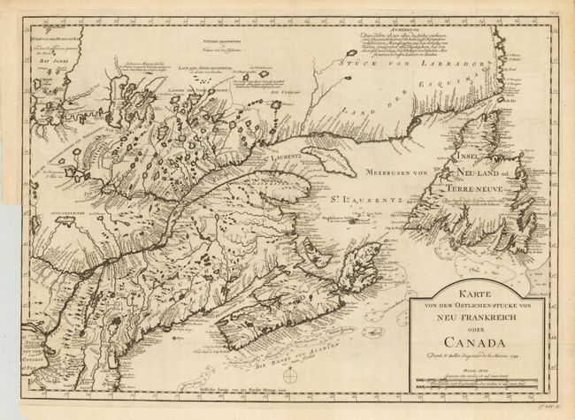
Auction 135, Lot 127
Subject: Colonial New England and Canada
Bellin, Jacques Nicolas
Karte von dem Ostlichen-Stucke von Neu Frankreich oder Canada, 1744
Size: 22 x 15.5 inches (55.9 x 39.4 cm)
Estimate: $400 - $500
Sold for: $250
Closed on 2/16/2011
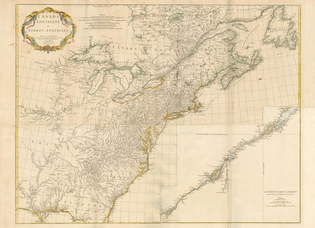
Auction 135, Lot 128
Subject: Colonial United States and Canada
Anville, Jean Baptiste Bourguignon d'
Canada Louisiane et Terres Angloises, 1755
Size: 44.5 x 34 inches (113 x 86.4 cm)
Estimate: $2,500 - $3,500
Sold for: $1,600
Closed on 2/16/2011
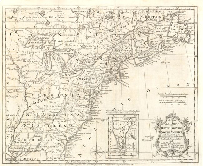
Auction 135, Lot 129
Subject: Colonial United States and Canada
Kitchin, Thomas
A New Map of the British Dominions in North America; with the Limits of the Governments Annexed thereto by the Late Treaty of Peace, and Settled by Proclamation, October 7th, 1763, 1763
Size: 12 x 9.5 inches (30.5 x 24.1 cm)
Estimate: $500 - $600
Sold for: $275
Closed on 2/16/2011
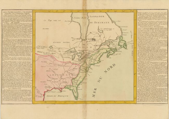
Auction 135, Lot 130
Subject: Colonial United States and Canada
Clouet, Jean Baptiste Louis
[Des Possessions Francoises Aujourd'hui sous la Domination Angloises ...], 1767
Size: 13.7 x 12.3 inches (34.8 x 31.2 cm)
Estimate: $180 - $220
Unsold
Closed on 2/16/2011
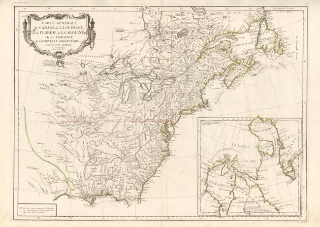
Auction 135, Lot 131
Subject: Colonial United States and Canada
D'Anville/Santini
Carte Generale du Canada, de la Louisiane, de la Floride, de la Caroline, de la Virginie, de la Nouvelle Angleterre etc. par le Sr. d'Anville, 1776
Size: 25.8 x 18.8 inches (65.5 x 47.8 cm)
Estimate: $600 - $800
Sold for: $400
Closed on 2/16/2011
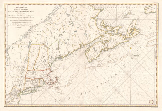
Auction 135, Lot 132
Subject: Colonial New England and Canada
Sartine
Carte Reduite des Cotes Orientales de l'Amerique Septentrionale Contenant Celles des Provinces de New-York et de la Nouvelle Angleterre, Celles de l'Acadie ou Nouvelles Ecosse, de L'Ile Royale, de L'Ile St.Jean, avec L'Interieure du Pays…, 1780
Size: 34.3 x 23 inches (87.1 x 58.4 cm)
Estimate: $1,900 - $2,200
Sold for: $1,200
Closed on 2/16/2011
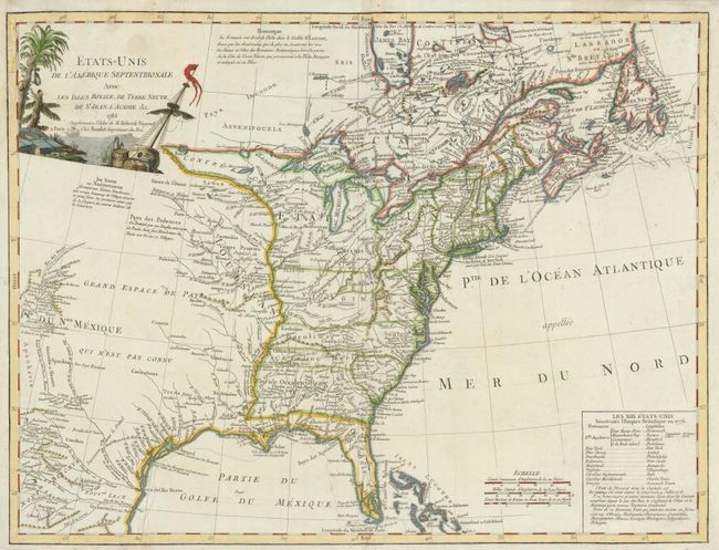
Auction 135, Lot 133
Subject: United States and Canada
Robert de Vaugondy/Boudet
Etats-Unis de l'Amerique Septentrionale avec les Isles Royale, de Terre Neuve, de St. Jean, l'Acadie &c., 1785
Size: 24.5 x 18.6 inches (62.2 x 47.2 cm)
Estimate: $800 - $1,000
Sold for: $600
Closed on 2/16/2011
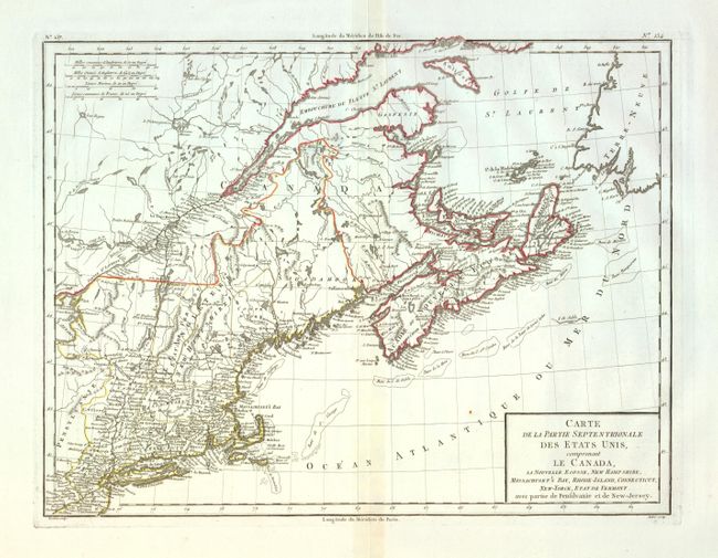
Auction 135, Lot 134
Subject: Eastern Canada & United States
Tardieu, Pierre Francois
Carte de la Partie Septentrionale des Etats Unis, comprenant le Canada, La Nouvelle Ecosse, New Hampshire, Massachuset's Bay, Rhode-Island, Connecticut, New-Yorck, Etat de Vermont avec partie de Pensilvanie et de New-Jersey, 1797
Size: 16.5 x 12.7 inches (41.9 x 32.3 cm)
Estimate: $300 - $400
Sold for: $170
Closed on 2/16/2011
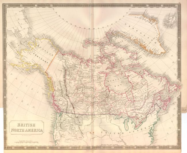
Auction 135, Lot 135
Subject: Canada and United States
Hall, Sidney
British North America, 1848
Size: 20 x 16.3 inches (50.8 x 41.4 cm)
Estimate: $200 - $250
Unsold
Closed on 2/16/2011
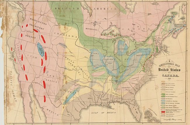
Auction 135, Lot 136
Subject: Canada & United States
Hitchcock, Edward
A Geological Map of the United States and Canada, 1853
Size: 24.4 x 16.7 inches (62 x 42.4 cm)
Estimate: $400 - $500
Sold for: $550
Closed on 2/16/2011
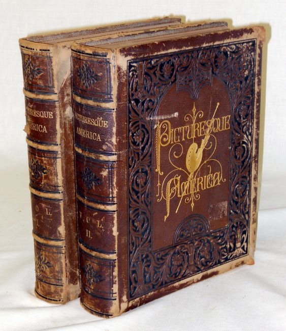
Auction 135, Lot 137
Subject: Canada and United States
Bryant, William C.
[2 Volumes] Picturesque America; or, the Land we Live in…, 1872-74
Size: 10.5 x 13 inches (26.7 x 33 cm)
Estimate: $400 - $600
Sold for: $300
Closed on 2/16/2011
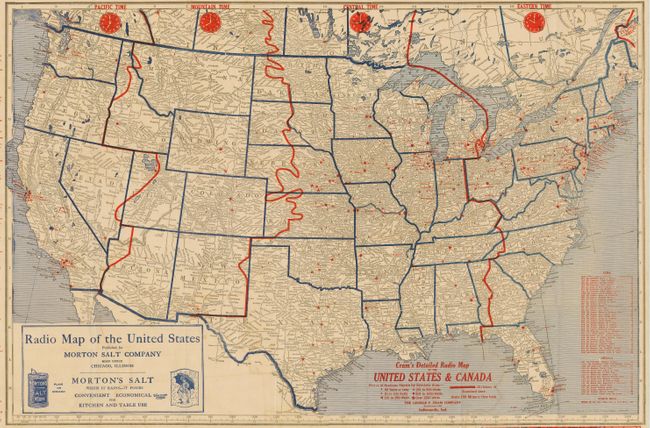
Auction 135, Lot 138
Subject: United States and Canada
Cram, George F. & Company
Cram's Detailed Radio Map of the United States and Canada, 1926
Size: 29 x 19.3 inches (73.7 x 49 cm)
Estimate: $100 - $150
Sold for: $350
Closed on 2/16/2011
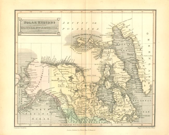
Auction 135, Lot 139
Subject: Canadian Arctic and Alaska
Tegg, Thomas
Polar Regions including British Nth. America, &c., 1820
Size: 10 x 8.2 inches (25.4 x 20.8 cm)
Estimate: $100 - $140
Sold for: $70
Closed on 2/16/2011
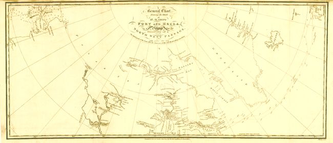
Auction 135, Lot 140
Subject: Canada & Alaska
[Lot of 2] General Chart Shewing the Track of H.M. Ships Fury and Hecla… [and] Carte des Voyages du King George et de la Reine Charlotte…, 1787-1824
Size: See Description
Estimate: $400 - $800
Unsold
Closed on 2/16/2011
Auction 135, Lot 141
Subject: Western United States and Canada
Burr, David H.
The North-West Coast of North America and adjacent Territories…, 1840
Size: 21.3 x 16 inches (54.1 x 40.6 cm)
Estimate: $275 - $325
Sold for: $240
Closed on 2/16/2011
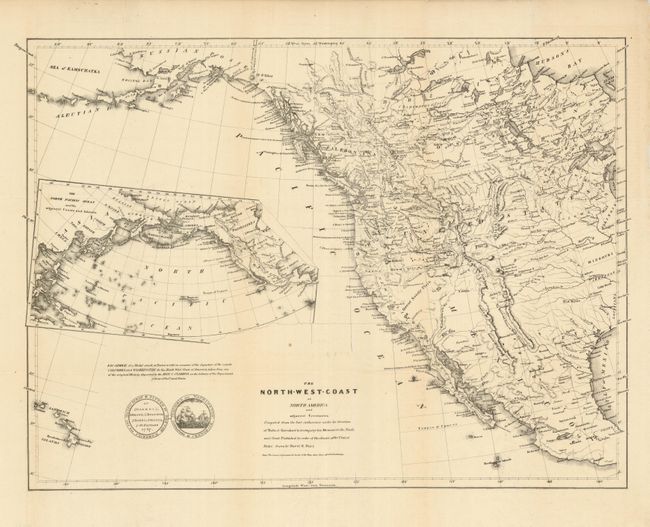
Auction 135, Lot 142
Subject: Western United States and Canada
Parker, Samuel (Rev.)
Journal of an Exploring Tour Beyond the Rocky Mountains … with a Map of Oregon Territory, 1840
Size: 5 x 7.8 inches (12.7 x 19.8 cm)
Estimate: $500 - $600
Sold for: $550
Closed on 2/16/2011
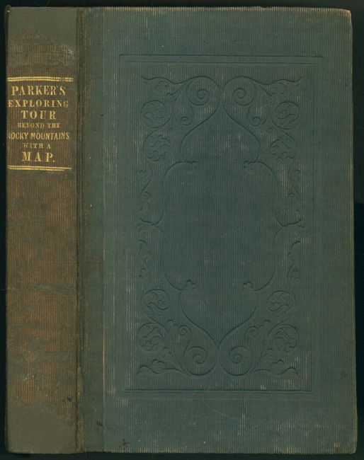
Auction 135, Lot 143
Subject: Western United States and Canada
Railroad Companies, (Various)
Canadian Rockies Showing Main Line of Canadian Pacific Ry. with Branch Lines & Steamship Connections, 1926
Size: 46.6 x 16.7 inches (118.4 x 42.4 cm)
Estimate: $100 - $150
Sold for: $170
Closed on 2/16/2011
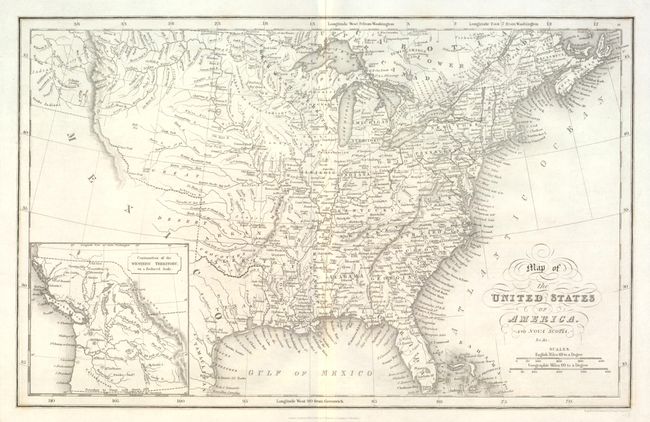
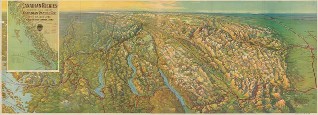
Auction 135, Lot 144
Subject: United States
Hinton, Simpkin & Marshall
Map of the United States of America and Nova Scotia, &c.&c., 1832
Size: 15.6 x 9.8 inches (39.6 x 24.9 cm)
Estimate: $200 - $250
Sold for: $120
Closed on 2/16/2011
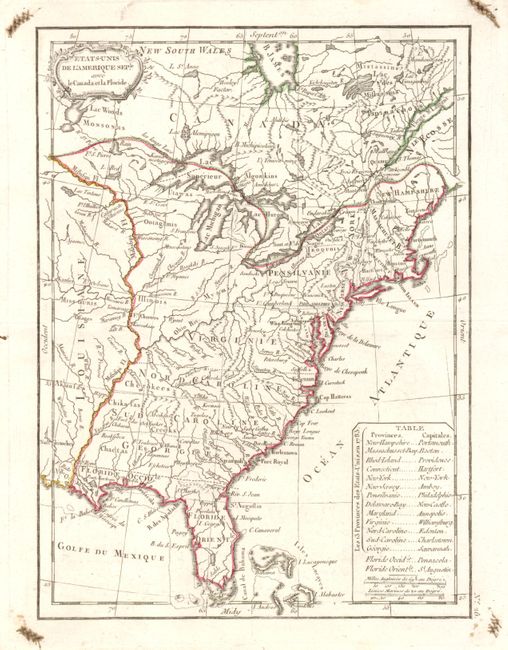
Auction 135, Lot 161
Subject: Eastern United States
Lattre, Jean
Etats-Unis de l'Amerique Seple avec le Canada et la Floride, 1790
Size: 7.3 x 9.8 inches (18.5 x 24.9 cm)
Estimate: $200 - $250
Sold for: $160
Closed on 2/16/2011
35 lots