Filtered by Category:Canada(Show All Categories)
Showing results for:Auction 120
Catalog Archive
39 lots
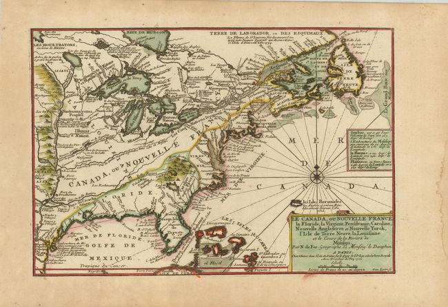
Auction 120, Lot 114
Subject: Colonial North America
Fer, Nicolas de
Le Canada, ou Nouvelle France, la Floride, la Virginie, Pensilvanie, Caroline, Nouvelle Angleterre et Nouvelle Yorck, l'Isle de Terre Neuve, la Louisiane et le cours de la Riviere de Misisipi, 1702
Size: 13.5 x 9 inches (34.3 x 22.9 cm)
Estimate: $850 - $950
Sold for: $750
Closed on 7/18/2007
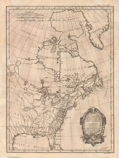
Auction 120, Lot 118
Subject: Colonial United States and Canada
Bonne, Rigobert
Partie du Nord de l'Amerique Septentrionale pour Servir a l'Histoire Philosophique et Politque…, 1774
Size: 9.3 x 12.6 inches (23.6 x 32 cm)
Estimate: $250 - $300
Sold for: $180
Closed on 7/18/2007
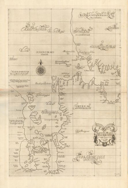
Auction 120, Lot 122
Subject: Canada - Hudson Bay
Dudley, Robert (Sir)
Carta Particolare dello Istreto e Mare Iscoperto de Heno. Hudson Ingilese nel 1611, 1661
Size: 18.5 x 28 inches (47 x 71.1 cm)
Estimate: $4,750 - $5,500
Unsold
Closed on 7/18/2007
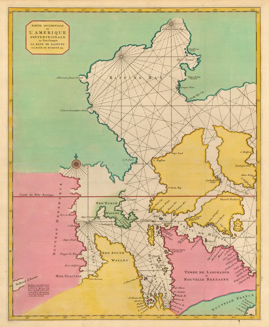
Auction 120, Lot 123
Subject: Canada - Hudson Bay
Mortier, Pierre
Partie Occidentale de l'Amerique Septentrionale, ou sont Compris la Baye de Baffins, la Baye de Hudson, &c., 1695
Size: 18.4 x 22.7 inches (46.7 x 57.7 cm)
Estimate: $700 - $1,000
Sold for: $500
Closed on 7/18/2007
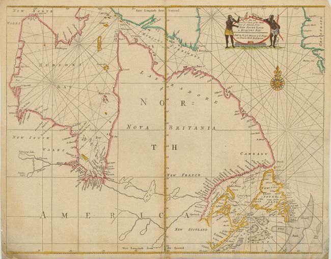
Auction 120, Lot 124
Subject: Eastern Canada
Mount & Page
A New and Correct Chart of the North Part of America from New Found Land to Hudsons Bay, 1753
Size: 21.8 x 17 inches (55.4 x 43.2 cm)
Estimate: $500 - $600
Sold for: $300
Closed on 7/18/2007
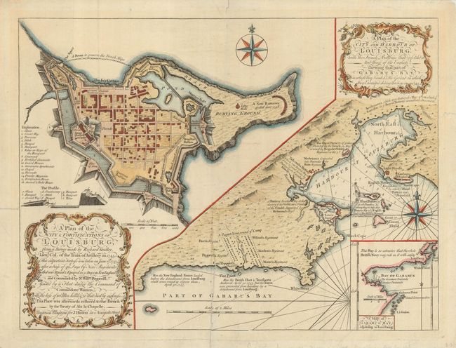
Auction 120, Lot 125
Subject: Canada, Louisbourg, Cape Breton
Gridley, Richard (Lt. Col.)
A Plan of the City & Fortifications of Louisburg… [on sheet with] A Plan of the City and Harbour of Louisburg…, 1758
Size: 14.4 x 10.8 inches (36.6 x 27.4 cm)
Estimate: $250 - $300
Sold for: $250
Closed on 7/18/2007
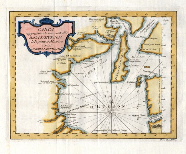
Auction 120, Lot 126
Subject: Canada - Hudson Bay
Rossi, Veremondo
Carta rappresentante una parte dlla Baja d'Hudson, e le Regioni a Maestro dell'America Settentrle., 1763
Size: 10.5 x 8.1 inches (26.7 x 20.6 cm)
Estimate: $140 - $200
Sold for: $100
Closed on 7/18/2007
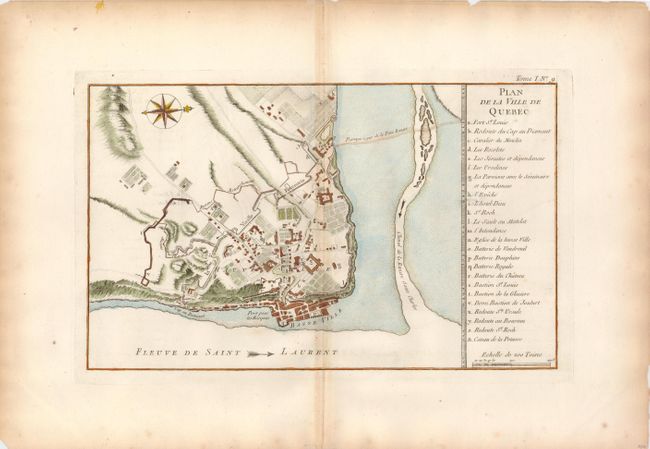
Auction 120, Lot 127
Subject: Canada - Quebec
Bellin, Jacques Nicolas
Plan de la Ville de Quebec, 1764
Size: 13.5 x 8.1 inches (34.3 x 20.6 cm)
Estimate: $160 - $200
Sold for: $120
Closed on 7/18/2007
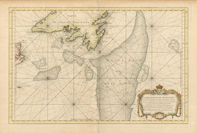
Auction 120, Lot 128
Subject: Canada - Atlantic Ocean
Bellin, Jacques Nicolas
Carte Reduite du Grand Banc et d'Une Partie de l'Isle de Terre Neuve…, 1764
Size: 32 x 20.8 inches (81.3 x 52.8 cm)
Estimate: $550 - $650
Sold for: $325
Closed on 7/18/2007
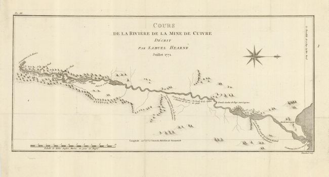
Auction 120, Lot 129
Subject: Canada - Arctic
Hearne, Samuel
Cours de la Riviere de la Mine de Cuivre Decrit par Samuel Hearne, 1771
Size: 17 x 7.8 inches (43.2 x 19.8 cm)
Estimate: $150 - $200
Sold for: $140
Closed on 7/18/2007
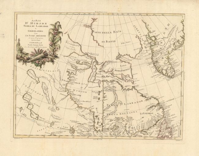
Auction 120, Lot 130
Subject: Canada - Greenland
Zatta, Antonio
La Baja d'Hudson Terra di Labrador e Groenlandia con le Isole Adiacenti, 1778
Size: 15.8 x 11.7 inches (40.1 x 29.7 cm)
Estimate: $200 - $300
Sold for: $160
Closed on 7/18/2007
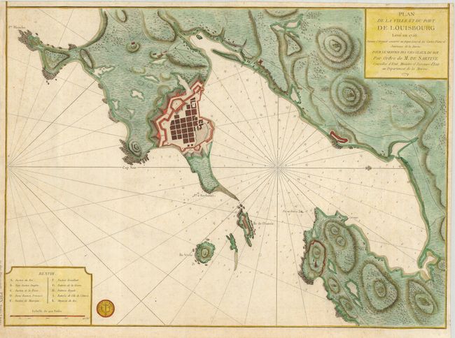
Auction 120, Lot 131
Subject: Canada, Louisbourg, Cape Breton
Depot de la Marine
Plan de la Ville et du Port de Louisbourg Leve en 1756…, 1779
Size: 23 x 16.6 inches (58.4 x 42.2 cm)
Estimate: $700 - $900
Sold for: $650
Closed on 7/18/2007
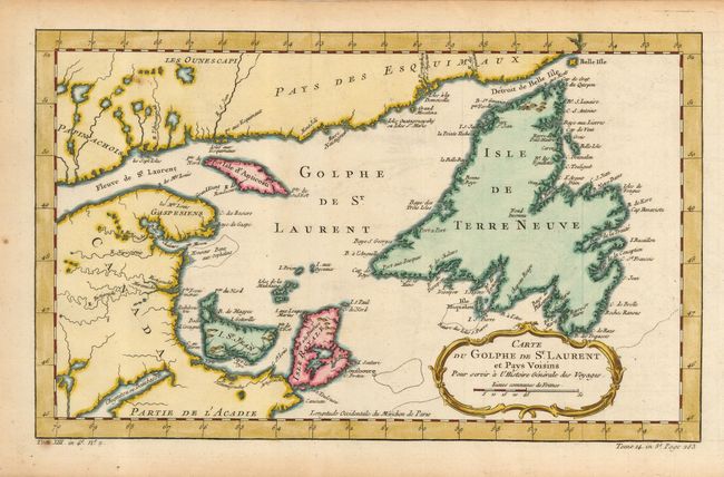
Auction 120, Lot 132
Subject: Canada
Bellin, Jacques Nicolas
Carte du Golphe de St. Laurent et Pays Voisins, 1780
Size: 14.2 x 8.6 inches (36.1 x 21.8 cm)
Estimate: $140 - $180
Sold for: $160
Closed on 7/18/2007
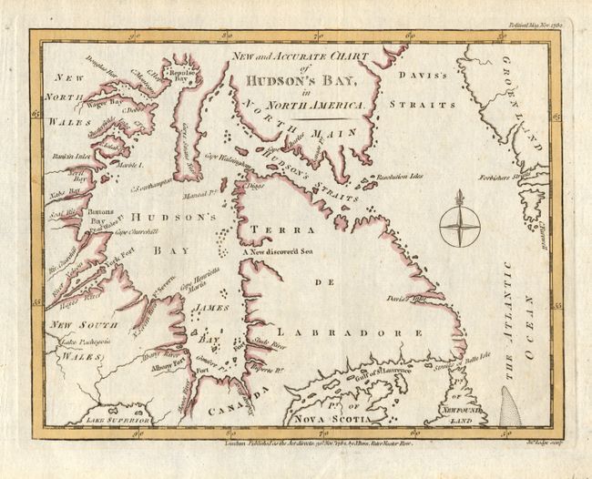
Auction 120, Lot 133
Subject: Canada - Hudson Bay
Lodge, John
New and Accurate Chart of Hudson's Bay, in North America, 1782
Size: 9 x 6.9 inches (22.9 x 17.5 cm)
Estimate: $80 - $150
Unsold
Closed on 7/18/2007
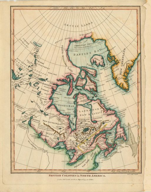
Auction 120, Lot 134
Subject: Canada - Hudson Bay - Arctic
Wilkes, J.
British Colonies in North America, 1797
Size: 7.1 x 9 inches (18 x 22.9 cm)
Estimate: $300 - $400
Sold for: $220
Closed on 7/18/2007
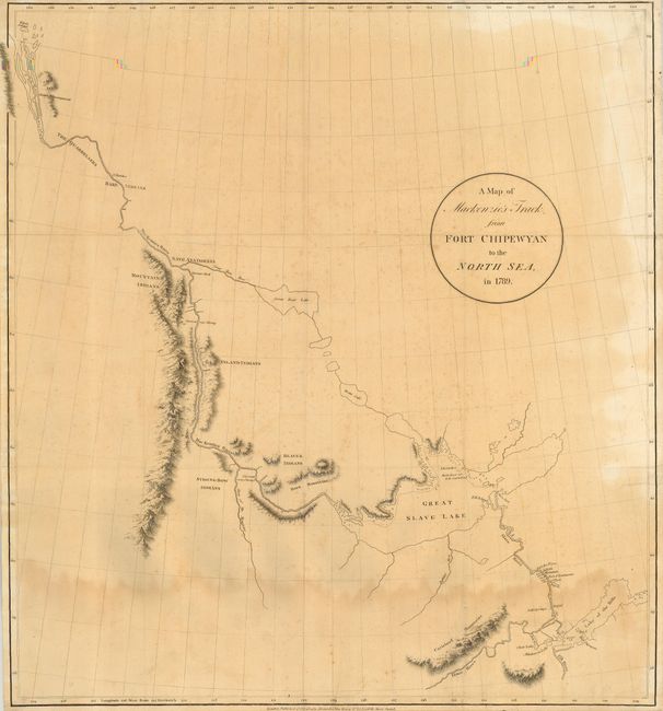
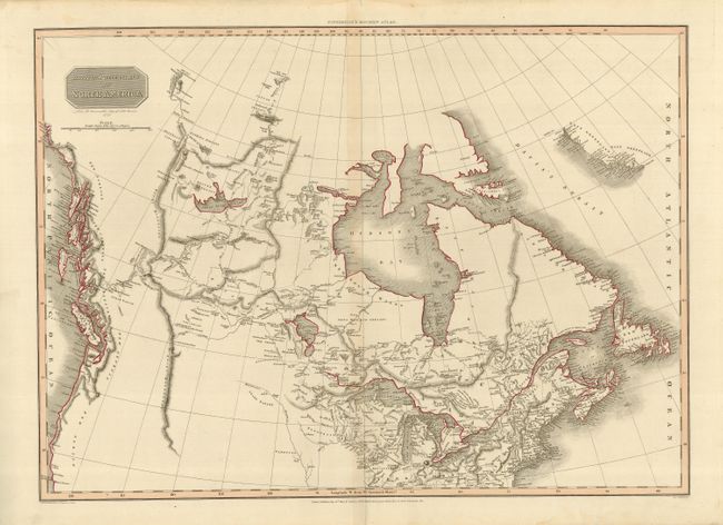
Auction 120, Lot 135
Subject: Central Canada
Mackenzie, Alexander
A Map of Mackenzie's Track from Fort Chipewyan to the North Sea, in 1789, 1801
Size: 22 x 23.8 inches (55.9 x 60.5 cm)
Estimate: $400 - $600
Sold for: $300
Closed on 7/18/2007
Auction 120, Lot 136
Subject: Canada
Pinkerton, John
British Possessions in North America, 1814
Size: 27 x 19.5 inches (68.6 x 49.5 cm)
Estimate: $200 - $250
Sold for: $230
Closed on 7/18/2007
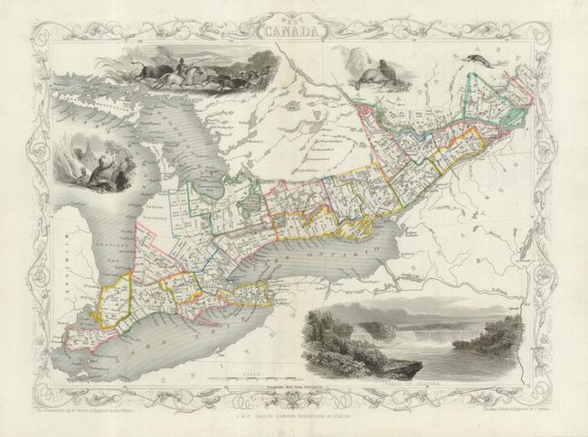
Auction 120, Lot 137
Subject: Canada
Tallis, John
[Lot of 3] West Canada [and] East Canada, and New Brunswick [and] British America, 1850
Size: 13 x 10 inches (33 x 25.4 cm)
Estimate: $250 - $350
Sold for: $300
Closed on 7/18/2007
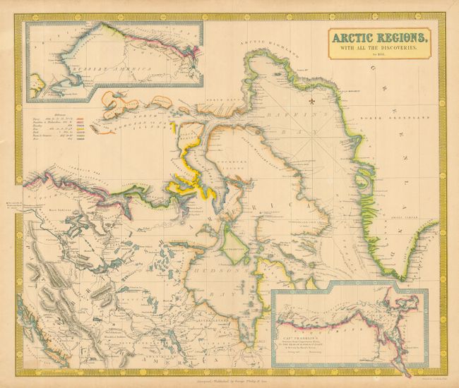
Auction 120, Lot 138
Subject: Canadian Arctic
Philip, George
[Lot of 2] Arctic Regions, with All the Discoveries, to 1851 [together with] Arctic Regions, with All the Discoveries, to 1853, 1851/53
Size: 23.8 x 19.8 inches (60.5 x 50.3 cm)
Estimate: $300 - $500
Unsold
Closed on 7/18/2007
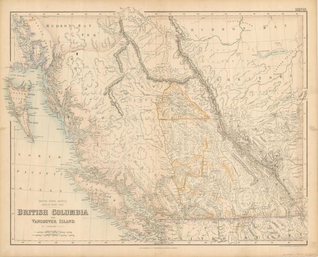
Auction 120, Lot 139
Subject: Western Canada
Bartholomew, John
British Columbia and Vancouver Island, 1865
Size: 21.2 x 16.6 inches (53.8 x 42.2 cm)
Estimate: $180 - $220
Sold for: $190
Closed on 7/18/2007
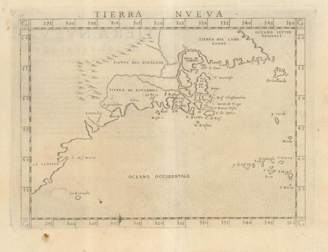
Auction 120, Lot 140
Subject: Colonial United States & Canada
Ruscelli, Girolamo
Tierra Nueva, 1574
Size: 9.5 x 7 inches (24.1 x 17.8 cm)
Estimate: $1,200 - $1,400
Unsold
Closed on 7/18/2007
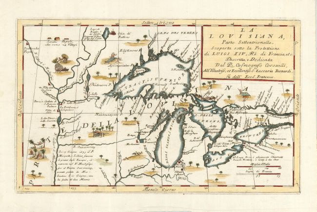
Auction 120, Lot 142
Subject: Great Lakes, United States & Canada
Coronelli, Vincenzo Maria
La Louisiana, Parte Settentrionalle, Scoperta Sotto la Protettione di Luigi XIV, Re di Francia, etc. Descritta, e Dedicata, 1695
Size: 16.8 x 10 inches (42.7 x 25.4 cm)
Estimate: $3,500 - $4,250
Sold for: $4,250
Closed on 7/18/2007
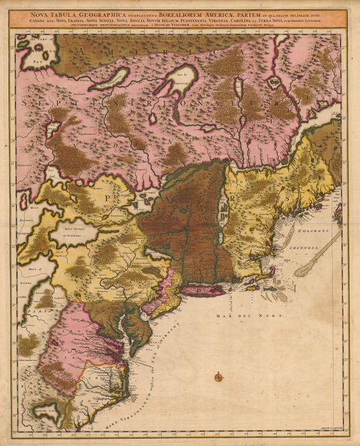
Auction 120, Lot 143
Subject: Colonial United States & Canada
Visscher, Nicolas
[Lot of 2] Nova Tabula Geographica Complectens Borealiorem Americae Partem… [and] Carte Nouvelle contenant la Partie d'Amerique la Plus Septentrionale…, 1699
Size: 18.6 x 23.5 inches (47.2 x 59.7 cm)
Estimate: $1,800 - $2,200
Sold for: $2,300
Closed on 7/18/2007
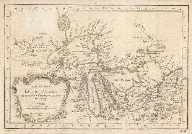
Auction 120, Lot 144
Subject: Great Lakes, United States & Canada
Bellin, Jacques Nicolas
Carte des Lacs du Canada Pour servir a l'Histoire Generale des Voyages, 1757
Size: 11.4 x 7.6 inches (29 x 19.3 cm)
Estimate: $550 - $600
Unsold
Closed on 7/18/2007
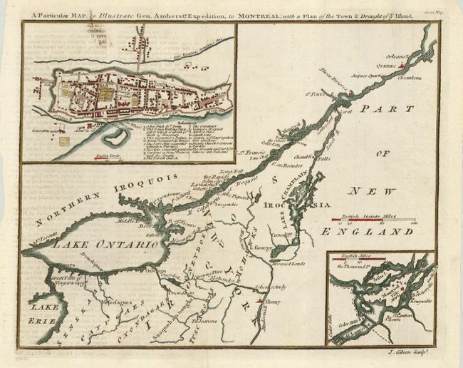
Auction 120, Lot 145
Subject: United States & Canada
Gibson, John
A Particular Map, to Illustrate Gen. Amherst's Expedition, to Montreal; with a Plan of the Town & Draught of ye Island, 1759
Size: 9 x 7 inches (22.9 x 17.8 cm)
Estimate: $150 - $180
Sold for: $150
Closed on 7/18/2007
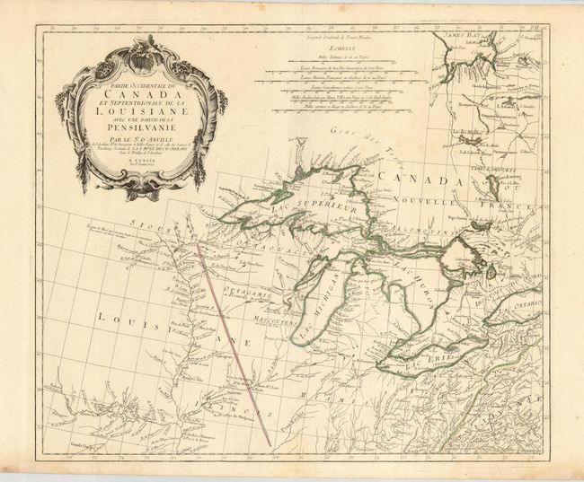
Auction 120, Lot 146
Subject: Great Lakes, United States & Canada
D'Anville/Santini
Partie Occidentale du Canada et Septentrionale de la Louisiane avec une Partie de la Pensilvanie, 1775
Size: 22.5 x 19 inches (57.2 x 48.3 cm)
Estimate: $1,100 - $1,400
Sold for: $800
Closed on 7/18/2007
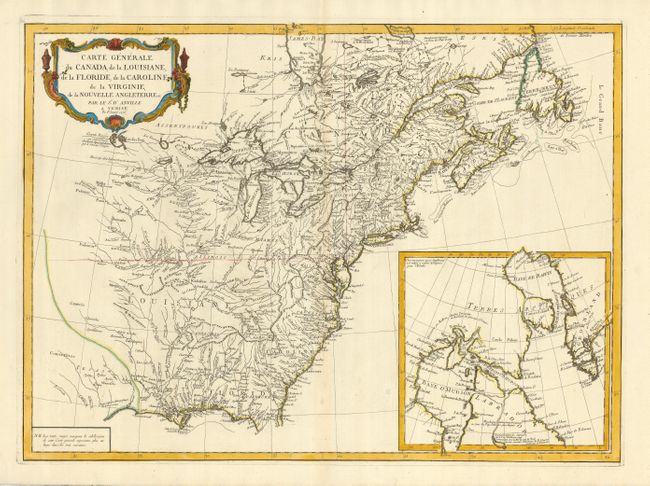
Auction 120, Lot 147
Subject: United States & Canada
D'Anville/Santini
Carte Generale du Canada, de la Louisiane, de la Floride, de la Caroline, de la Virginie, de la Nouvelle Angleterre etc. par le Sr. d'Anville, 1776
Size: 25.5 x 18.8 inches (64.8 x 47.8 cm)
Estimate: $1,200 - $1,400
Sold for: $850
Closed on 7/18/2007
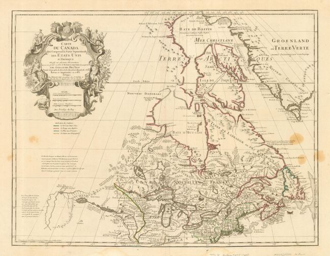
Auction 120, Lot 148
Subject: United States & Canada
Delisle/Dezauche
Carte du Canada qui Comprend la Partie Septentrionale des Etats Unis…, 1783
Size: 25.3 x 19.5 inches (64.3 x 49.5 cm)
Estimate: $800 - $1,100
Sold for: $500
Closed on 7/18/2007
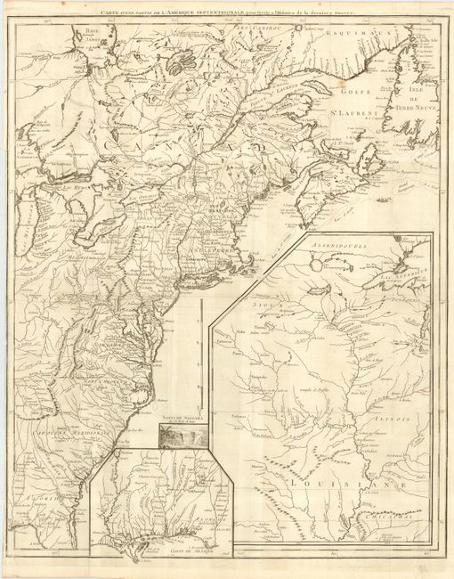
Auction 120, Lot 149
Subject: United States & Canada
Le Rouge, George Louis
Carte d'une Partie de l'Amerique Septentrionale, pour servir a l'Histoire de la derniere Guerre, 1787
Size: 19.5 x 24.2 inches (49.5 x 61.5 cm)
Estimate: $1,500 - $1,700
Sold for: $1,100
Closed on 7/18/2007
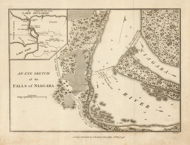
Auction 120, Lot 150
Subject: United States & Canada - Niagara Falls
Stockdale, John
An Eye Sketch of the Falls of Niagara, 1798
Size: 9 x 6.4 inches (22.9 x 16.3 cm)
Estimate: $100 - $150
Sold for: $130
Closed on 7/18/2007
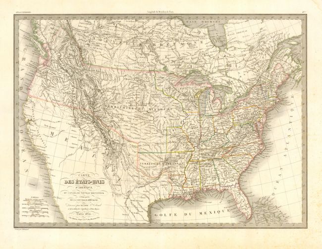
Auction 120, Lot 151
Subject: United States & Canada
Lapie, Alexander Emile & Pierre
Carte des Etats-Unis d'Amerique, du Canada, du Nouveau Brunswick et d'une partie de la Nouvelle Bretagne, 1832
Size: 21 x 15 inches (53.3 x 38.1 cm)
Estimate: $300 - $400
Sold for: $150
Closed on 7/18/2007
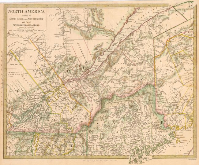
Auction 120, Lot 152
Subject: United States & Canada
SDUK Society for the Diffusion of Useful Knowledge
[Lot of 6] North America Sheet II, V, VIII, IX, X [and] XI, 1832-3
Size: See Description
Estimate: $275 - $325
Sold for: $200
Closed on 7/18/2007
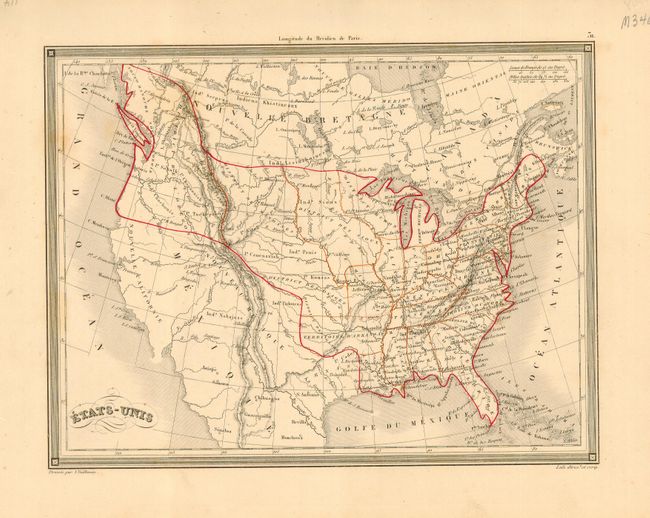
Auction 120, Lot 153
Subject: United States & Canada
Vuillemin, Alexander A.
Etats-Unis, 1840
Size: 10 x 7.5 inches (25.4 x 19.1 cm)
Estimate: $90 - $130
Sold for: $45
Closed on 7/18/2007
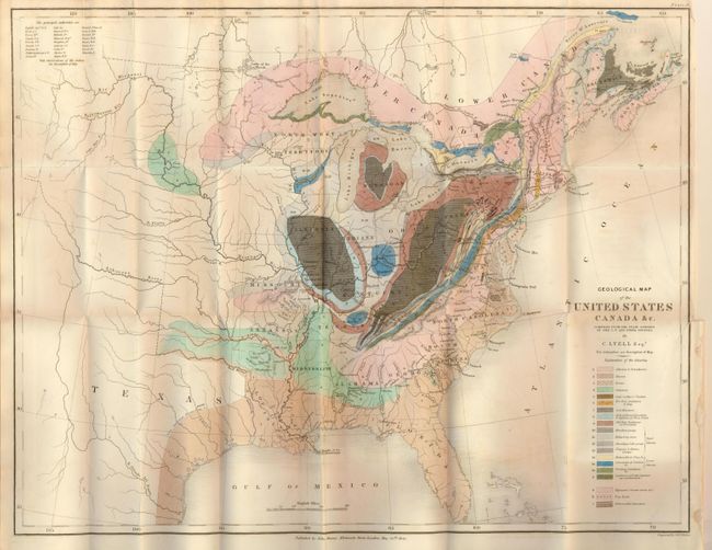
Auction 120, Lot 154
Subject: Eastern United States & Canada
Lyell, Charles
Geological Map of the United States Canada &c. Compiled from the State Surveys of the U.S. and Other Sources, 1845
Size: 19.8 x 15.3 inches (50.3 x 38.9 cm)
Estimate: $250 - $300
Sold for: $350
Closed on 7/18/2007
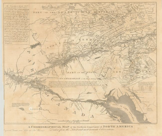
Auction 120, Lot 155
Subject: United States & Canada
Gavit, John
A Chorographical Map of the Northern Department of North America Drawn from the Latest and Most Accurate Observations, 1850
Size: 12.4 x 10 inches (31.5 x 25.4 cm)
Estimate: $100 - $150
Unsold
Closed on 7/18/2007
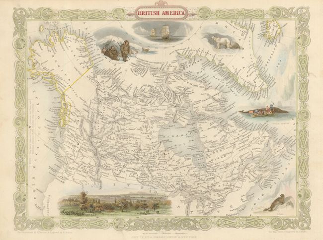
Auction 120, Lot 156
Subject: Canada and Alaska
Tallis, John
British America, 1865
Size: 13 x 10 inches (33 x 25.4 cm)
Estimate: $250 - $300
Sold for: $180
Closed on 7/18/2007
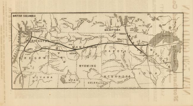
Auction 120, Lot 157
Subject: United States & Canada
Railroad Companies, (Various)
[Northern Pacific Railroad Route], 1870
Size: 13.7 x 6 inches (34.8 x 15.2 cm)
Estimate: $300 - $400
Sold for: $200
Closed on 7/18/2007
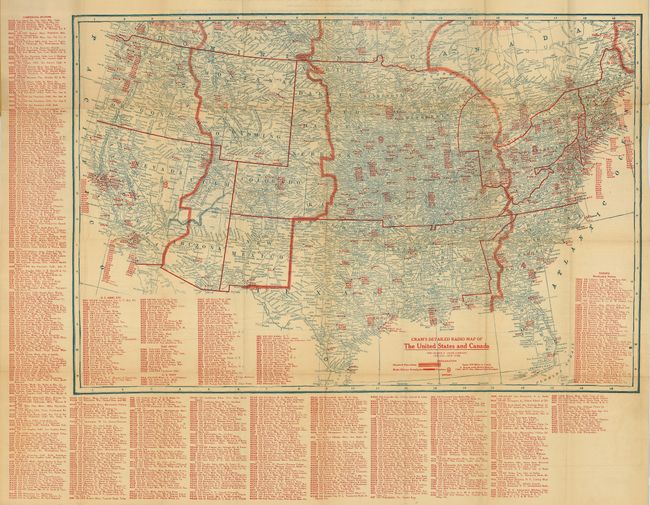
Auction 120, Lot 158
Subject: United States & Canada
Cram, George F. & Company
[Lot of 2] Cram's Detailed Radio Map of the United States and Canada [and] … Revised Edition 1923-1924, 1922-1923
Size: 29 x 19.8 inches (73.7 x 50.3 cm)
Estimate: $140 - $180
Sold for: $100
Closed on 7/18/2007
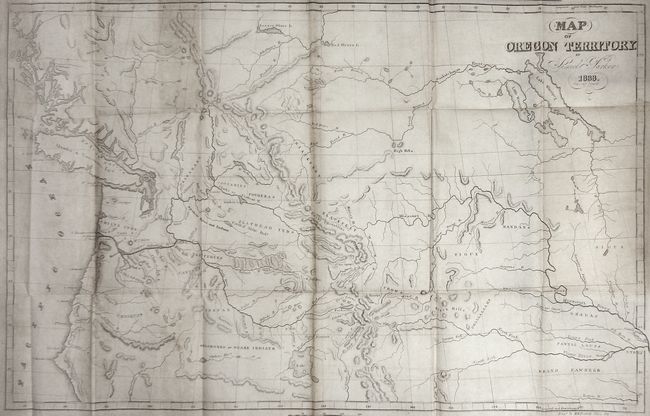
Auction 120, Lot 870
Subject: Exploration and Surveys
Parker, Samuel (Rev.)
Journal of an Exploring Tour Beyond the Rocky Mountains … with a Map of Oregon Territory, 1846
Size: 22 x 14 inches (55.9 x 35.6 cm)
Estimate: $450 - $550
Sold for: $650
Closed on 7/18/2007
39 lots