Filtered by Category:Canada(Show All Categories)
Showing results for:Auction 105
Catalog Archive
22 lots

Auction 105, Lot 98
Subject: Colonial North America
Visscher/Schenk
Nova Tabula Geographica complectens Borealiorem Americae Partem; in qua exacte delineatae sunt Canada sive Nova Francia, Nova Scotia, Nova Anglia, Novum Belgium, Pensylvania, Virginia, Carolina, et Terra Nova, cum Omnibus Littorum, 1715
Size: 19.7 x 23.4 inches (50 x 59.4 cm)
Estimate: $1,800 - $2,000
Sold for: $1,300
Closed on 12/3/2003

Auction 105, Lot 99
Subject: Colonial North America
Tirion, Isaac
Nieuwe Kaart van de Grootbrittannische Volkplantingen in Noord America…, 1755
Size: 17.8 x 14.4 inches (45.2 x 36.6 cm)
Estimate: $750 - $900
Sold for: $950
Closed on 12/3/2003

Auction 105, Lot 101
Subject: Colonial United States and Canada
Lodge, John
A Map of the British and French Settlements in North America, 1755
Size: 15 x 10.8 inches (38.1 x 27.4 cm)
Estimate: $350 - $450
Sold for: $600
Closed on 12/3/2003

Auction 105, Lot 102
Subject: Colonial North America
Homann Heirs
America Septentrionalis a Domino d'Anville in Galliis edita nunc in Anglia Coloniis in Interiorem Virginiam deductis nec non Fluvii Ohio cursu…, 1756
Size: 20 x 18 inches (50.8 x 45.7 cm)
Estimate: $600 - $800
Sold for: $800
Closed on 12/3/2003
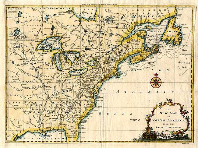
Auction 105, Lot 103
Subject: Colonial United States and Canada
Spilsbury, J.
A New Map of North America from the Latest Discoveries, 1761
Size: 14.5 x 10.8 inches (36.8 x 27.4 cm)
Estimate: $400 - $500
Sold for: $375
Closed on 12/3/2003

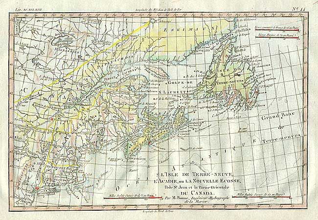
Auction 105, Lot 115
Subject: Canada - Maritimes
Bellin, Jacques Nicolas
Carte de l'Acadie, Isle Royale et Pais Voisins, 1757
Size: 13 x 8.3 inches (33 x 21.1 cm)
Estimate: $100 - $140
Sold for: $250
Closed on 12/3/2003
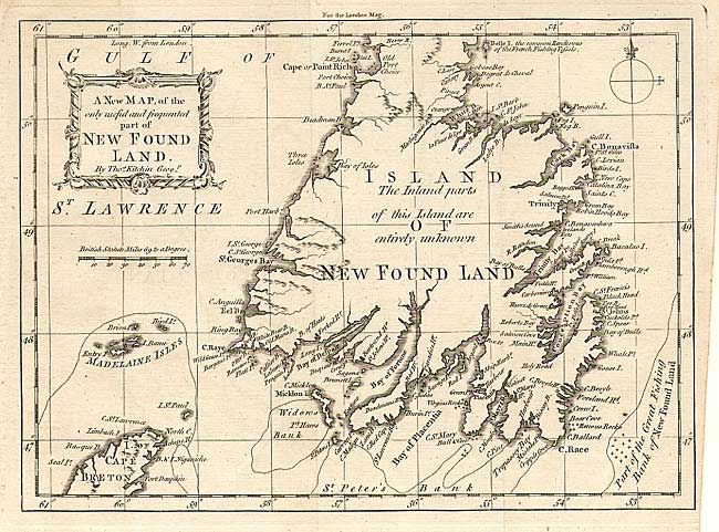
Auction 105, Lot 116
Subject: Newfoundland
Kitchin, Thomas
A New Map of the only useful and frequented part of New Found Land, 1762
Size: 9.5 x 7 inches (24.1 x 17.8 cm)
Estimate: $160 - $200
Sold for: $140
Closed on 12/3/2003
Auction 105, Lot 117
Subject: Canada
Bonne/Lattre
Partie de l'Amerique Septentrionale, qui comprend le Canada, la Louisiane, le Labrador, le Groenland, les Etats-Unis et la Floride, 1783
Size: 17.2 x 11.6 inches (43.7 x 29.5 cm)
Estimate: $275 - $325
Sold for: $200
Closed on 12/3/2003

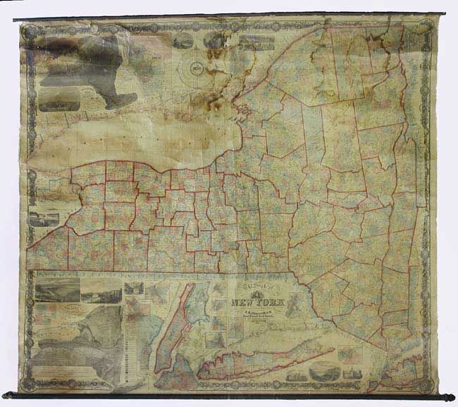
Auction 105, Lot 118
Subject: Canada
Thomas, Cowperthwait & Co.
Canada East formerly Lower Canada, 1854
Size: 15.7 x 12.5 inches (39.9 x 31.8 cm)
Estimate: $100 - $140
Sold for: $50
Closed on 12/3/2003
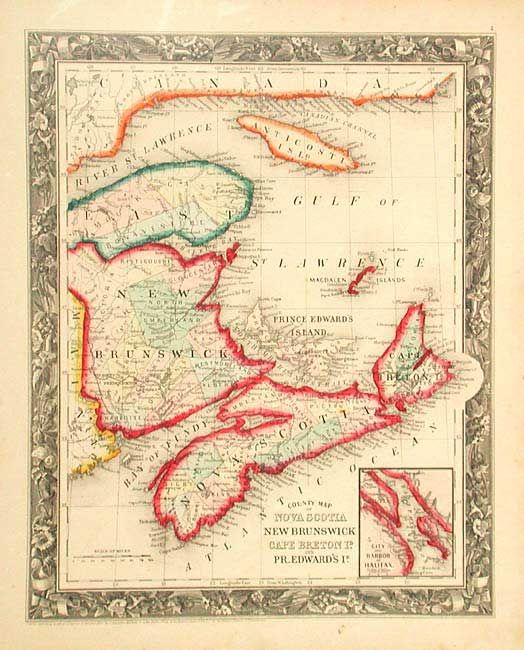
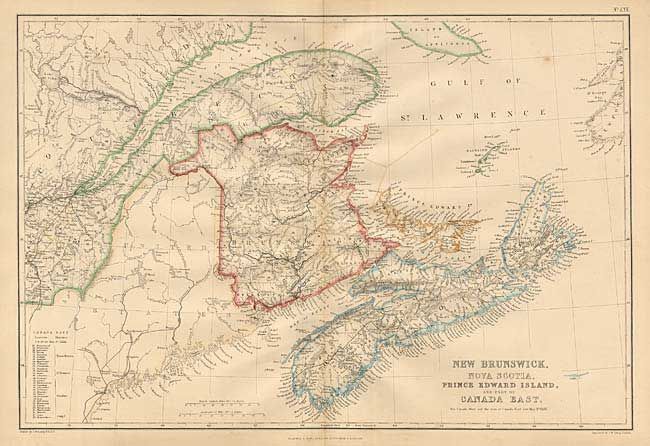
Auction 105, Lot 119
Subject: Canada
Mitchell, Samuel Augustus
County Map of Nova Scotia, New Brunswick, Cape Breton Id. and Prince Edward's Id., 1860
Size: 10.6 x 13.2 inches (26.9 x 33.5 cm)
Estimate: $60 - $80
Sold for: $45
Closed on 12/3/2003
Auction 105, Lot 120
Subject: Canada
Blackie, W. G. & Son
[Lot of 3 - Canada], 1860
Size: 19.5 x 13.5 inches (49.5 x 34.3 cm)
Estimate: $140 - $160
Sold for: $80
Closed on 12/3/2003
Auction 105, Lot 121
Subject: Canada and United States
Bonne, Rigobert
[Lot of 4], 1779
Size: 12.5 x 8.5 inches (31.8 x 21.6 cm)
Estimate: $600 - $700
Unsold
Closed on 12/3/2003
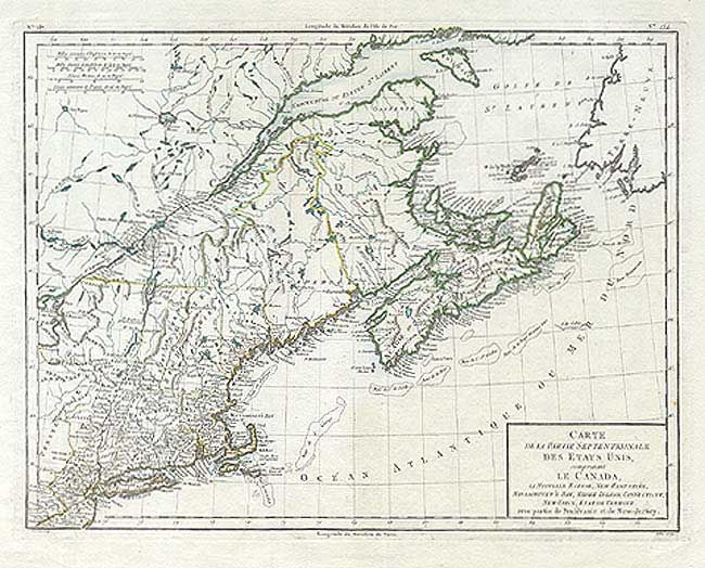
Auction 105, Lot 122
Subject: Canada & United States
Tardieu
Carte de la Partie Septentrionale des Etats Unis, comprenant le Canada, La Nouvelle Ecosse, New Hampshire, Massachuset's Bay, Rhode-Island, Connecticut, New-Yorck, Etat de Vermont avec partie de Pensilvanie et de New-Jersey, 1785
Size: 16.5 x 12.8 inches (41.9 x 32.5 cm)
Estimate: $450 - $550
Sold for: $425
Closed on 12/3/2003
Auction 105, Lot 123
Subject: Canada & United States
Forster, Georg
Karte des Nordens von America…, 1791
Size: 25.4 x 19 inches (64.5 x 48.3 cm)
Estimate: $650 - $750
Sold for: $375
Closed on 12/3/2003
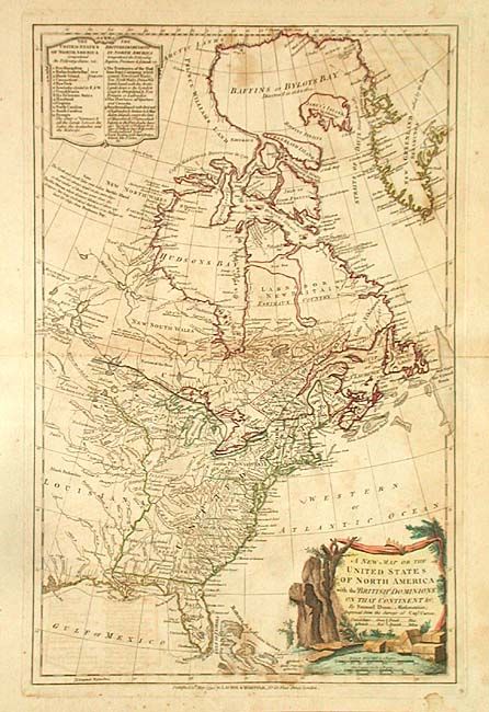
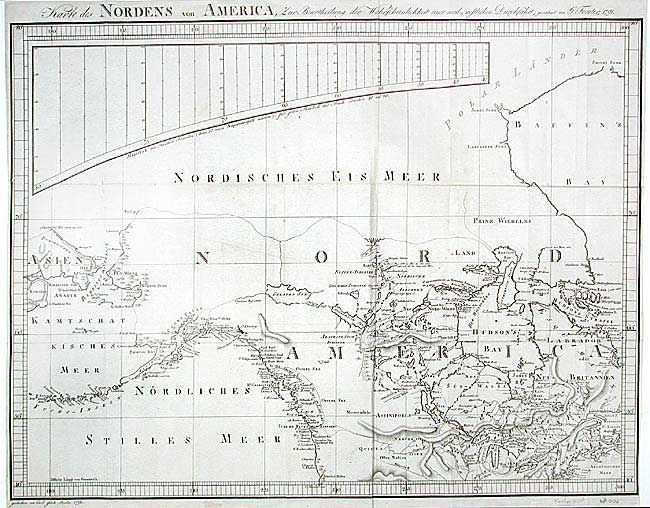
Auction 105, Lot 124
Subject: Canada & United States
Dunn, Samuel
A New Map of the United States of North America with the British Dominions on that Continent &c., 1794
Size: 12 x 18.6 inches (30.5 x 47.2 cm)
Estimate: $700 - $900
Sold for: $500
Closed on 12/3/2003
Auction 105, Lot 125
Subject: Canada & United States
Carey, Mathew
The British possessions in North America from the latest Authorites, 1814
Size: 17 x 14.6 inches (43.2 x 37.1 cm)
Estimate: $120 - $150
Sold for: $110
Closed on 12/3/2003
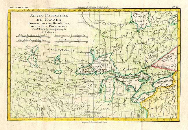
Auction 105, Lot 126
Subject: Canada & Great Lakes
Bonne, Rigobert
Partie Occidentale du Canada, Contenant les cinq Grands Lacs, avec les Pays Circonvoisins, 1780
Size: 12.5 x 8.4 inches (31.8 x 21.3 cm)
Estimate: $275 - $325
Sold for: $200
Closed on 12/3/2003

Auction 105, Lot 127
Subject: Western Canada & United States
La Perouse, Comte Jean F. Galoup, de
Carte Particuliere de la Cote du Nord-Ouest de l'Amerique reconnue par les Fregates Francaises la Boussole et l'Astrolabe en 1786. 2e. Feuille, 1799
Size: 27 x 19.6 inches (68.6 x 49.8 cm)
Estimate: $230 - $275
Unsold
Closed on 12/3/2003

Auction 105, Lot 128
Subject: Western Canada & United States
La Perouse, Comte Jean F. Galoup, de
Carte Generale d'une Partie de la Cote du Nord-Ouest de l'Amerique reconnue par les Fregates Francaises la Boussole et l'Astrolabe, 1797
Size: 19.5 x 27 inches (49.5 x 68.6 cm)
Estimate: $300 - $350
Sold for: $220
Closed on 12/3/2003

Auction 105, Lot 129
Subject: Western Canada & United States
Cook, James (Capt.)
Plan der Haven van Samgan Oodha in het Eiland van Oonalaska [together with] Schets van het Kanaal van Nootka, 1800
Size: See Description
Estimate: $100 - $140
Sold for: $80
Closed on 12/3/2003
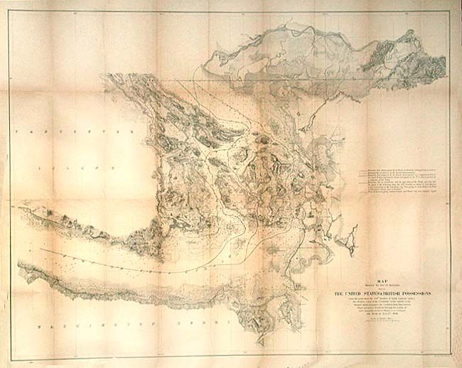
Auction 105, Lot 131
Subject: Canada & United States
U.S. Government
Map Showing the line of Boundary between The United States & British Possessions…, 1868
Size: 36 x 28.4 inches (91.4 x 72.1 cm)
Estimate: $300 - $400
Sold for: $325
Closed on 12/3/2003

Auction 105, Lot 542
Subject: Quebec, Canada
Haberman, F. X.
Prospect des Haupt Plazes der untern Stadt zu Quebec, 1760
Size: 16.5 x 12.5 inches (41.9 x 31.8 cm)
Estimate: $400 - $500
Sold for: $240
Closed on 12/3/2003
22 lots