Blame it on the Fog: Staten Island, Compagnies Land & Da Gama Land
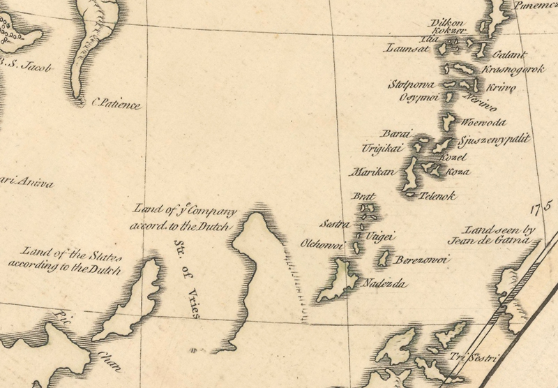
John Bayly, The Russian Empire in Asia, 1760. This map gives good detail of the Kuril Islands, yet still includes Staten Land and Compagnies Land “according to the Dutch” and De Gama Land “as seen by Jean de Gama.”
Blame it on the Fog: Staten Island, Compagnies Land & Da Gama Land
by Eliane Dotson
Early maps often include partially delineated floating strips of land, apparently seen by explorers navigating the seas. Some of these sightings of land turned out to be islands, others continents, and some were complete myths due to false reports and inaccurate coordinates. There is always a story behind who discovered these strips of land and how they first came to appear on maps. And there is often a separate, sometimes convoluted story about how they were depicted by cartographers and mapmakers over time. In this article I will share the stories behind the mapping of three adjacent landmasses northeast of Japan: Staten Island, Compagnies Land and Da Gama’s Land.
In 1643 Maarten Gerritsz de Vries was commissioned by the Dutch East India Company to explore the region north of Japan in search of Rica de Oro and Rica de Plata, fabled islands of gold and silver. These islands were first reported by Francisco Gali, who had heard of the islands while in Macao in 1582-83, and subsequently several explorers were sent to discover them. After spending some time on Honshu, Vries sailed northeast along the east coast of Hokkaido. His voyage was plagued with fog, making both sighting land and making landfall difficult. His ship was required to stay well away from the coastline as it continued northeast. As he reached the southern Kuril Islands, which were unknown to Europeans at the time, he named one of the islands "Staten Eylant" (now known as Iturup) after the Dutch States General. Continuing past the island, he made landfall briefly at the next strip of land and named it "Compagnies Landt" (now Urup) after the Dutch East India Company. It was unknown at the time whether Companies Land was a small island or a larger landmass, and possibly even part of the North American continent. Vries did not attempt to circumnavigate the island, but instead sailed north between Staten Island and Compagnies Land along a strait named after him: Vries Strait.
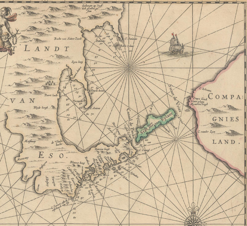
An account of Vries’ voyage was published in 1646, however his discoveries did not regularly appear on maps until more than a decade later. To date, the first known printed appearance of Staten Island and Compagnies Land, the latter of which was only partially delineated, is on Willem and Joan Blaeu’s wall map of the world from 1645-46, of which only one known example exists. Joan Blaeu also included the islands on his world map of 1648, which is also very scarce.
Joan Blaeu, Nova et Accuratissima Totius Terrarum Orbis Tabula, 1658. Blaeu’s folio-sized world map closely follows the cartography of his 1648 wall map, showing only the western coastline of “Compagnis Landt” separated from an unnamed Staten Island by “Straet Fries” (Vries Strait).
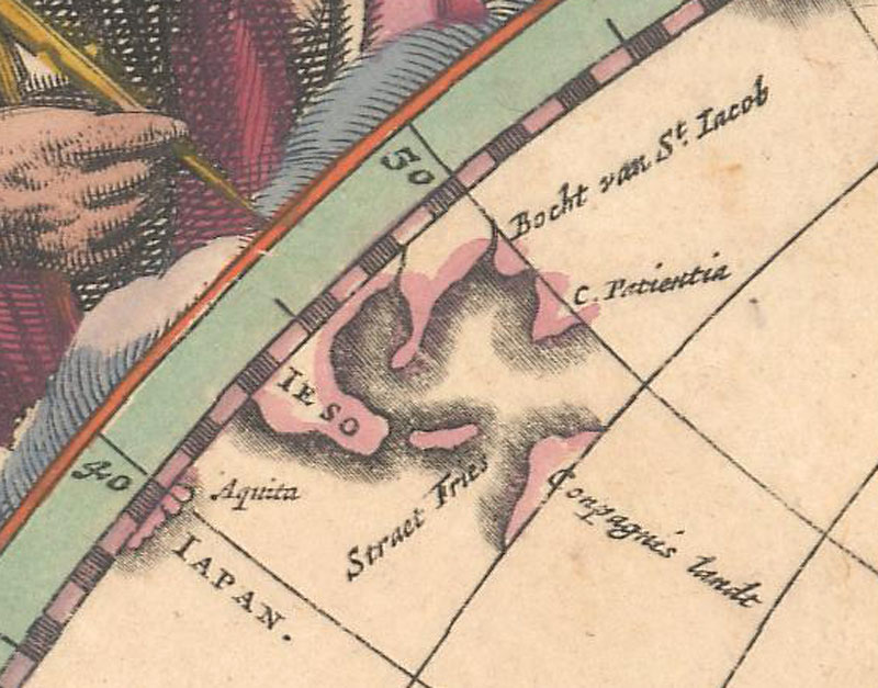
A more detailed depiction of the islands was included on Jan Jansson’s small map of Japan, Iaponia et Terra Eso, which Jansson had newly engraved for the final two editions of his Atlas Minor in 1648 and 1651, due to a break in the previous plate of Japan. While Jansson’s map follows the same outlines of the islands as on Blaeu’s maps of 1645-46 and 1648, it adds several place names, including two capes and a mountain on “Compagnies Landt” and a cape on “Staten Eyl.” Jansson subsequently created a folio-sized edition of this map for his Novus Atlas, first published in 1658, adding a few more place names to “Staten Eylant” and extending the coastlines of “Companies Landt” further east, making it significantly larger.
Jan Jansson, Iaponia et Terra Eso, 1648. The Atlas Minor edition of this map shows a smaller “Compagnies Landt.”
Jan Jansson, Nova et Accurata Iaponiae, Terrae Esonis. Ac Insularum Adjacentium, 1658. Jansson’s folio map extends the coastline of “Compagnies Land” to the east.
The islands began to appear more regularly on maps by other Dutch cartographers around 1660, with those of the world and Asia copying the coastlines from Blaeu’s world maps. Maps that focused on northern Asia and the North Pacific Ocean tended to follow Jansson’s more detailed depiction of the islands with an enlarged Compagnies Land. However in 1663, Jansson made a change to Henricus Hondius’ world map that launched a new vision for Compagnies Land. Jansson merged the concepts of a westward bulging North America with Vries’ discovery of Compagnies Land, thereby extending Compagnies Land across the entire North Pacific Ocean and connecting it with North America. It was a bold, misguided decision that Jansson would never again repeat on any other map, but one that would confuse cartographers for the next century.
Henricus Hondius, Nova Totius Terrarum Orbis Geographica ac Hydrographica Tabula, 1630. Showing the northwest coast of North America.
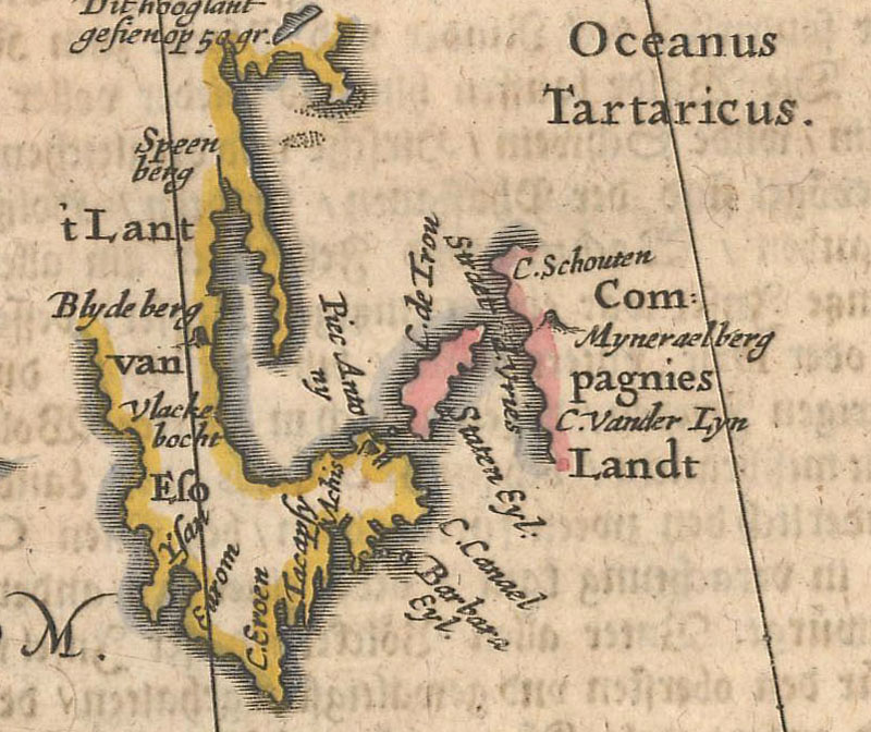
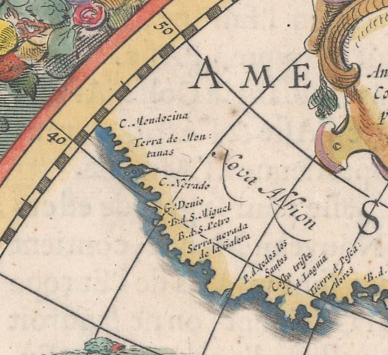
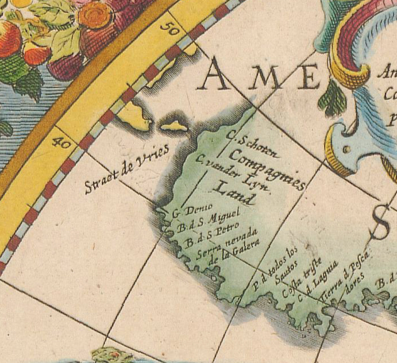
Jan Jansson, Nova Totius Terrarum Orbis Geographica ac Hydrographica Tabula, 1663. Jansson replaces “Nova Albion” and “C. Mendocino” with “Compagnies Land.” Also shown is an unnamed Staten Island and “Straet de Vries.”
Another compounding factor in the mapping of Compagnies Land was the report by explorer João da Gama. In 1589-90, Da Gama sighted land northeast of Japan while traversing the Pacific Ocean on his way to Mexico. It is unknown exactly where De Gama sighted the land and how long the coastline was, thereby becoming a point of speculation for cartographers. The “discoveries” by Da Gama and Vries were sometimes merged together as one island or landmass, and sometimes they appeared adjacent to one another. Interestingly, although Da Gama’s voyage was over 50 years prior to Vries’ expedition, the land discovered by Da Gama didn’t appear on maps until around 1700, well after Compagnies Land was a common addition on Dutch maps. Although it is unclear why Da Gama was suddenly introduced on maps more than a century after his voyage, his name first appeared on French maps by Delisle and Jaillot. In fact, notations regarding Da Gama are almost exclusively found on French, English and German maps, while Dutch maps continued to focus on Vries’ discoveries.
Guillaume Delisle, L'Asie Dressee sur les Observations de l'Academie Royale des Sciences..., 1700. Delisle’s map is one of the first to mention Da Gama, who is noted adjacent to "Terre de la Compagnie," with Vries Strait completely omitted. Staten Island is translated into French as "I. des Etats.”
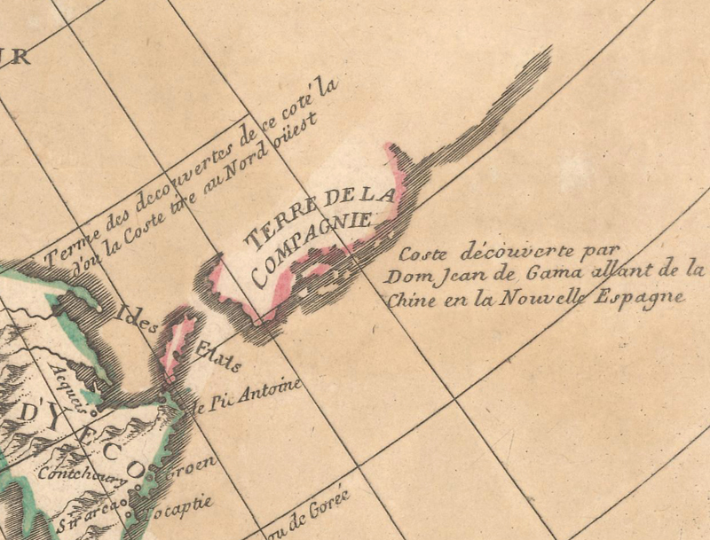
Delisle/Buache, Carte des Nouvelles Decouvertes au Nord de la Mer du Sud, 1752. This map shows three separate islands: “I. des Etats,” “Terre de la Compagnie” and “Terres vues par Jean de Gama,” which is only partially delineated.
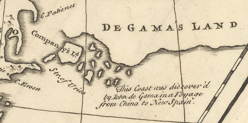
Emanuel Bowen, A New & Accurate Map of Asia Drawn from Actual Surveys, 1752. A large, undefined “De Gama’s Land” stretches eastward off the map. One of the adjacent islands is named “Company’s L.d.” Staten Island is not named, but “Str. Of Vries” is labeled.
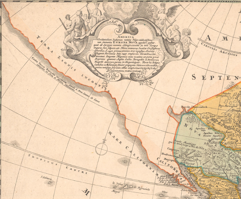
Johann Baptist Homann, Totius Americae Septentrionalis et Meridionalis Novissima Repraesentatio quam ex Singulis Recentium Geographorum Tabulis, 1730. The western coastline of North America stretches from California to Asia with a note that the “unknown” coast was detected by Da Gama.
Despite new information on the mapping of the Kuril Islands and North Pacific Ocean during the early 18th century, depictions of Compagnies Land and Gama Land persisted on European maps through the 1780s. Staten Land, on the other hand, was not necessarily poorly depicted, but simply mis-named. Maps of the Kuril Islands based on Russian explorations reached Europe as early as the 1720s, as evidenced by Johann Baptist Homann’s map of the Kamchatka Peninsula and Kuril Islands published circa 1725 (Geographica Nova ex Oriente Gratiosissima, Duabus Tabulis Specialissimis Contenta…). Vitus Bering's expeditions in the North Pacific between 1727-41 provided further confirmation that a large landmass didn’t exist in the region. Yet even maps that showed and properly named many of the Kuril Islands, thereby incorporating the latest geographical information, still held on to the inaccuracies of Vries’ and Da Gama’s reports.
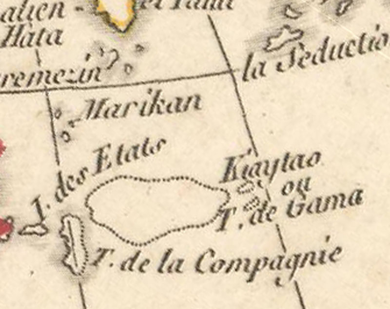
Rigobert Bonne, Carte Generale de l’Asie, 1781. A few Kuril Islands appear, as well as “I. des Etats,” “T. de la Compagnie” and “Kiaytao ou T. de Gama.” The latter two islands are drawn with dotted lines, indicating they are conjectural.
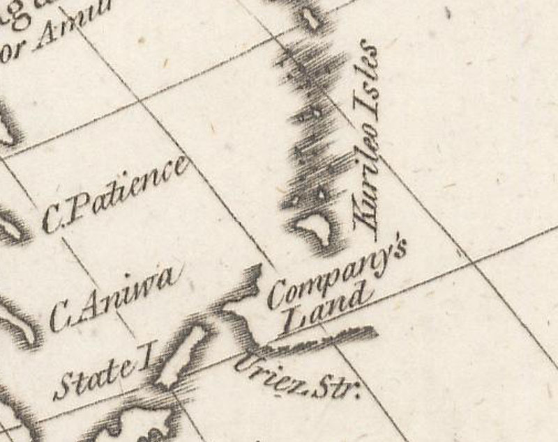
John Harrison, Asia, Drawn from the Latest and Best Authorities, 1787. The Kuril Islands are labeled, but “State I.” and “Company’s Land” are still shown. The strait between the islands is named “Vries Str.,” a name which is still in use today.
The original story of Vries’ discovery and naming of Staten Island and Compagnies Land was relatively straight-forward, but it allowed for open-ended and conjectural cartography. The fog that prevented the Vries expedition from circumnavigating Compagnies Land forced mapmakers to guess the size and shape of the island. Cartographers then conflated the reports by Vries and Da Gama, while mixing in other misconceptions about the North American continent to create exaggerated landmasses in the North Pacific. It all started with a few brief sightings of land, and ended up with mysterious islands and stretches of land that persisted on maps for over a century.
References
Brooke-Hitching, Edward, The Phantom Atlas – The Greatest Myths, Lies and Blunders on Maps, Chronicle Books, San Francisco, 2018.
Davison, Dr. Julian & Tan Lay Kee, Mapping the Continent of Asia, Antiques of the Orient Pte. Ltd., Singapore, 1994.
Hubbard, Jason C., Japoniae Insulae The Mapping of Japan, Hes & de Graaf Publishers BV, Houten, Netherlands, 2012.
Shirley, Rodney, The Mapping of the World – Early Printed World Maps 1472-1700, The Holland Press Limited, London, 1987.