Showing Featured Lots(remove filter)
Showing results for:Auction 193
Catalog Archive
58 lots
Page 1 of 2
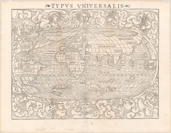
Auction 193, Lot 3
Subject: World
Munster, Sebastian
Typus Universalis, 1545
Size: 13.6 x 10.3 inches (34.5 x 26.2 cm)
Estimate: $4,000 - $5,000
Rare First Block of Munster's World Map
Sold for: $4,750
Closed on 6/21/2023
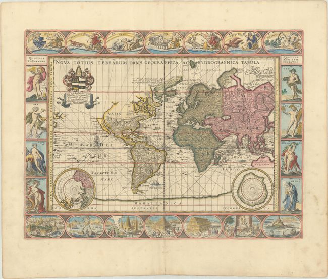
Auction 193, Lot 9
Subject: World
Pitt, Moses
Nova Totius Terrarum Orbis Geographica ac Hydrographica Tabula, 1680
Size: 20.9 x 15.6 inches (53.1 x 39.6 cm)
Estimate: $11,000 - $13,000
Scarce Pitt Edition of Carte-a-Figures Map of the World
Sold for: $8,000
Closed on 6/21/2023
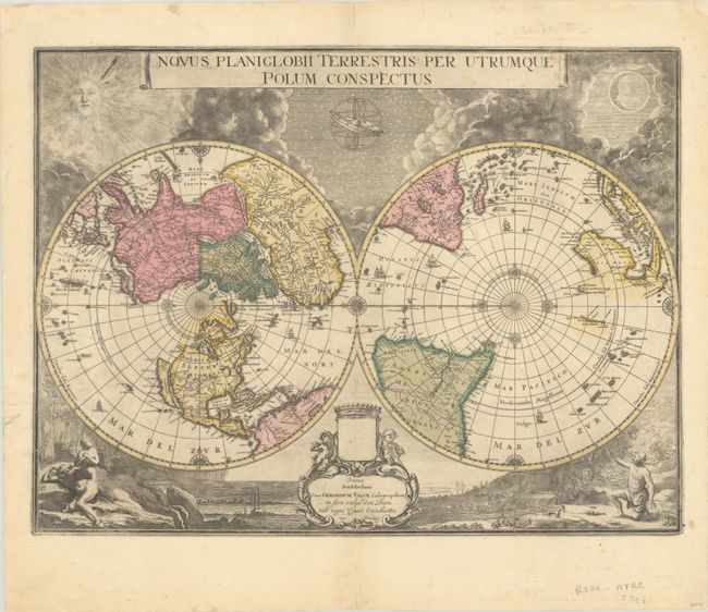
Auction 193, Lot 10
Subject: World
Blaeu/Valck
Novus Planiglobii Terrestris per Utrumque Polum Conspectus, 1695
Size: 21.3 x 16 inches (54.1 x 40.6 cm)
Estimate: $4,750 - $6,000
Superb World Map on a Polar Projection in Full Contemporary Color
Sold for: $3,500
Closed on 6/21/2023
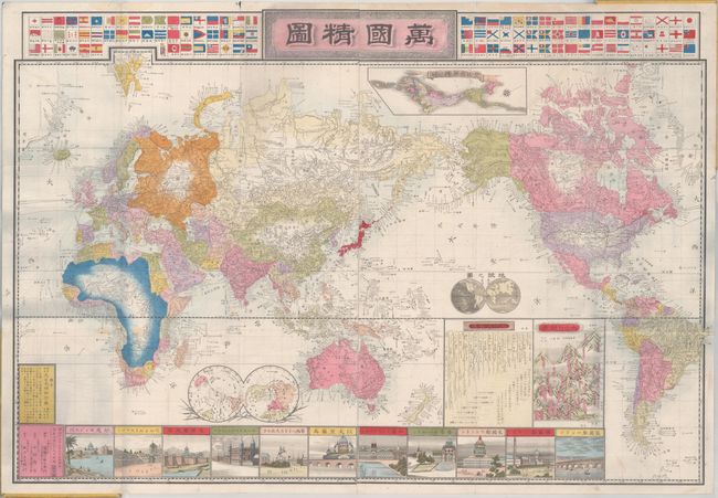
Auction 193, Lot 35
Subject: World
[Meiji Shinsen Bankoku Seizu - New Meiji Edition - Map of the World], 1886
Size: 33.3 x 22.6 inches (84.6 x 57.4 cm)
Estimate: $600 - $750
Decorative and Detailed Japanese World Map
Sold for: $900
Closed on 6/21/2023
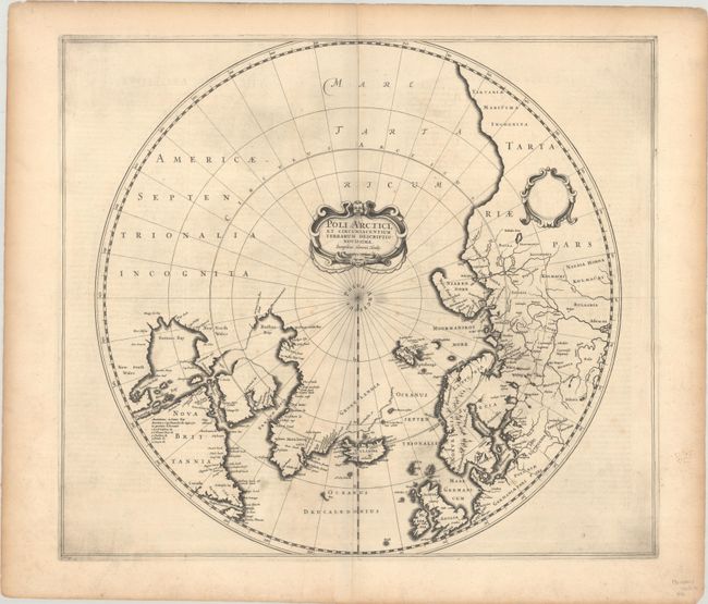
Auction 193, Lot 46
Subject: North Pole
Hondius, Henricus
Poli Arctici, et Circumiacentium Terrarum Descriptio Novissima, 1636
Size: 19.5 x 17 inches (49.5 x 43.2 cm)
Estimate: $1,600 - $1,900
Extremely Rare Second State
Sold for: $1,000
Closed on 6/21/2023
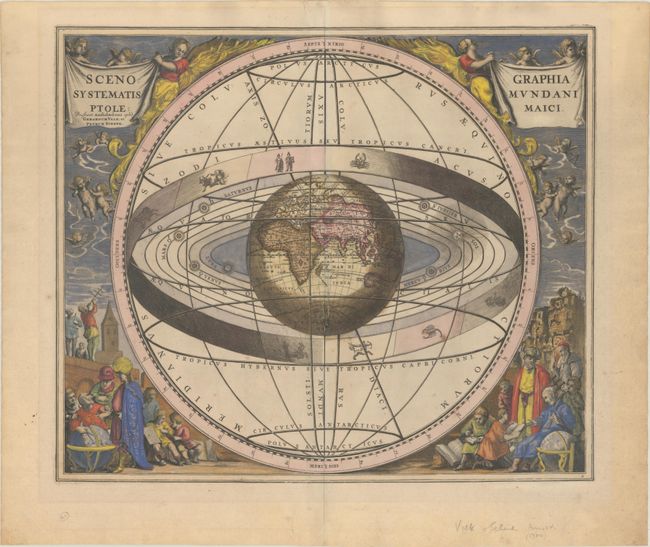
Auction 193, Lot 52
Subject: Solar System
Cellarius/Schenk & Valck
Scenographia Systematis Mundani Ptolemaici, 1708
Size: 19.8 x 16.8 inches (50.3 x 42.7 cm)
Estimate: $1,400 - $1,800
Cellarius' Striking Chart of the Ptolemaic Cosmography
Sold for: $750
Closed on 6/21/2023
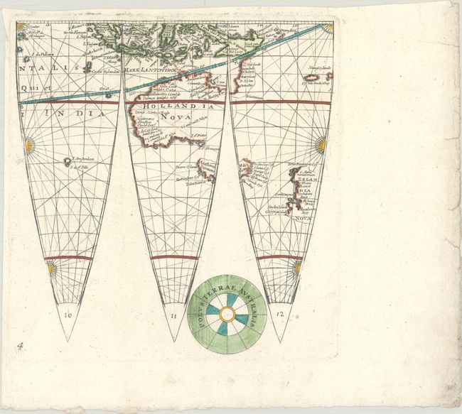
Auction 193, Lot 55
Subject: Globe Gores
Eimmart, Georg Christoph
[Lot of 3 - Globe Gores] L. Fl. cum Geographica Orbis Terrarum Descriptio Secundum..., 1705
Size: 9.3 x 9.8 inches (23.6 x 24.9 cm)
Estimate: $950 - $1,200
Rare Globe Gores of Southern Hemisphere
Sold for: $800
Closed on 6/21/2023
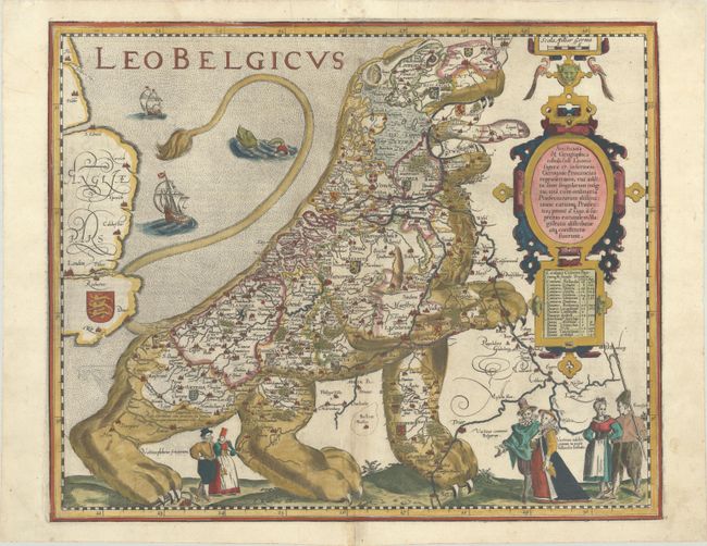
Auction 193, Lot 61
Subject: Cartographic Miscellany, Low Countries
Keere, Pieter Van Den
Leo Belgicus, 1622
Size: 17.9 x 14.6 inches (45.5 x 37.1 cm)
Estimate: $14,000 - $16,000
The Most Popular of the "Lions of Belgium"
Sold for: $10,000
Closed on 6/21/2023
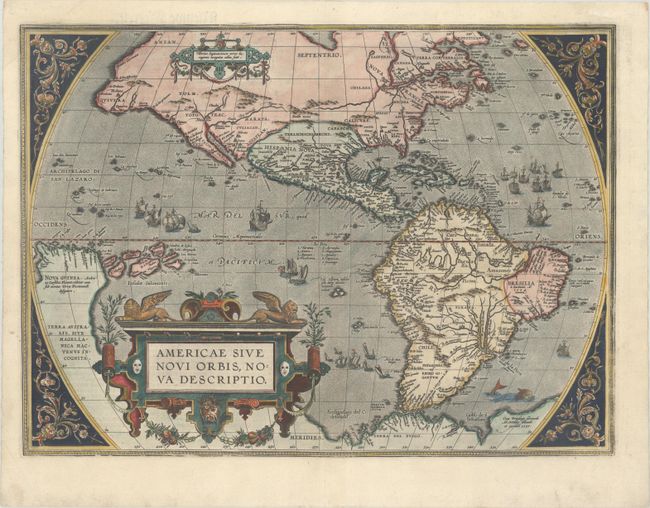
Auction 193, Lot 64
Subject: Western Hemisphere - America
Ortelius, Abraham
Americae sive Novi Orbis, Nova Descriptio, 1587
Size: 19.1 x 14 inches (48.5 x 35.6 cm)
Estimate: $6,000 - $7,500
Ortelius' Influential Map of the New World
Sold for: $7,000
Closed on 6/21/2023
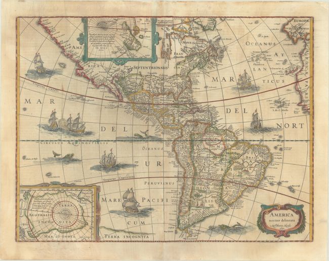
Auction 193, Lot 66
Subject: Western Hemisphere - America
Hondius, Henricus
America Noviter Delineata, 1631
Size: 19.6 x 14.9 inches (49.8 x 37.8 cm)
Estimate: $1,600 - $1,900
Hondius' Decorative Map of the Americas in Full Contemporary Color
Sold for: $2,300
Closed on 6/21/2023
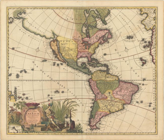
Auction 193, Lot 68
Subject: Western Hemisphere - America
Allard, Carel
Recentissima Novi Orbis, sive Americae Septentrionalis et Meridionalis Tabula, 1700
Size: 23.1 x 19.7 inches (58.7 x 50 cm)
Estimate: $1,600 - $1,900
Allard's Elaborate Map of the Western Hemisphere in Full Contemporary Color
Sold for: $1,600
Closed on 6/21/2023
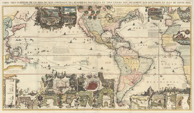
Auction 193, Lot 70
Subject: Western Hemisphere - America
Chatelain, Henry Abraham
Carte Tres Curieuse de la Mer du Sud Contenant des Remarques Nouvelles et Tres Utiles non Seulement sur les Ports et Iles de Cette Mer..., 1719
Size: 56 x 31.3 inches (142.2 x 79.5 cm)
Estimate: $14,000 - $16,000
Spectacular Wall Map Celebrating the New World
Sold for: $15,000
Closed on 6/21/2023

Auction 193, Lot 79
Subject: Western Hemisphere - America
Laurie & Whittle
A New Map of the Whole Continent of America, Divided into North and South and West Indies. Wherein Are Exactly Described the United States of North America..., 1794
Size: 46.8 x 40.6 inches (118.9 x 103.1 cm)
Estimate: $1,000 - $1,300
Impressive Four-Sheet Map Featuring Two Possible Locations for a River of the West
Sold for: $750
Closed on 6/21/2023
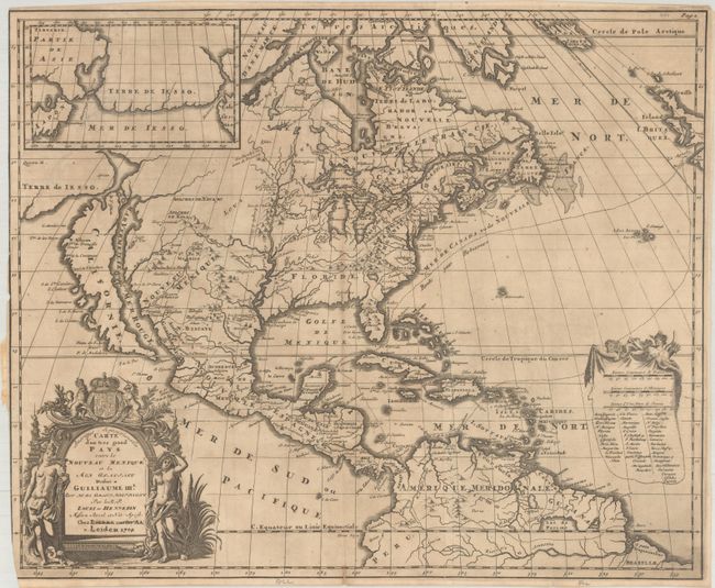
Auction 193, Lot 87
Subject: Colonial North America
Hennepin, Louis de (Fr.)
Amerique Septentrionalis Carte d'un Tres Grand Pays Entre le Nouveau Mexique et la Mer Glaciale..., 1704
Size: 20.5 x 17 inches (52.1 x 43.2 cm)
Estimate: $2,750 - $3,500
Hennepin's Influential Map of North America
Sold for: $3,750
Closed on 6/21/2023
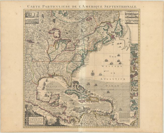
Auction 193, Lot 99
Subject: Colonial Eastern North America & West Indies
Popple/Covens & Mortier
A Map of the British Empire in America with the French, Spanish and the Dutch Settlements Adjacent Thereto , 1741
Size: 18.9 x 19.3 inches (48 x 49 cm)
Estimate: $2,750 - $3,500
Index Sheet of Popple's Map
Sold for: $1,750
Closed on 6/21/2023
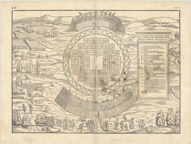
Auction 193, Lot 112
Subject: Montreal, Canada
Gastaldi/Ramusio
La Terra de Hochelaga Nella Nova Francia, 1556
Size: 14.4 x 10.6 inches (36.6 x 26.9 cm)
Estimate: $2,000 - $2,300
The First Published Plan of a Settlement in North America
Sold for: $1,500
Closed on 6/21/2023

Auction 193, Lot 116
Subject: Colonial Eastern United States & Canada
Fer, Nicolas de
Carte de la Nouvelle France, ou se Voit le Cours des Grandes Rivieres de S. Laurens & de Mississipi Aujour d'hui S. Louis, aux Environs des-quelles se Trouvent les Etats, Pais, Nations, Peuples &c. de la Floride..., 1720
Size: 21.5 x 19.6 inches (54.6 x 49.8 cm)
Estimate: $2,400 - $3,000
Striking Map of French Colonial Possessions in Full Contemporary Color
Sold for: $3,000
Closed on 6/21/2023
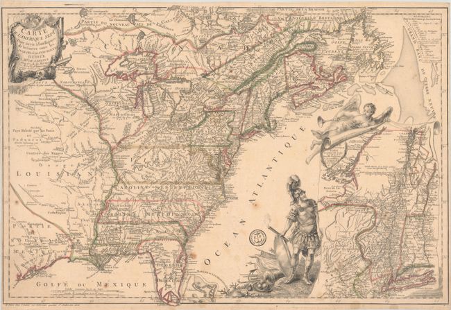
Auction 193, Lot 119
Subject: Colonial Eastern United States & Canada
Beaurain, Jean Chev. De
Carte de l'Amerique Septle pour Servir a l'Intelligence de la Guerre Entre les Anglois et les Insurgents, 1777
Size: 24.4 x 16.4 inches (62 x 41.7 cm)
Estimate: $7,000 - $8,500
Important Map Published Just Prior to France's Entrance in the Revolutionary War
Sold for: $5,000
Closed on 6/21/2023
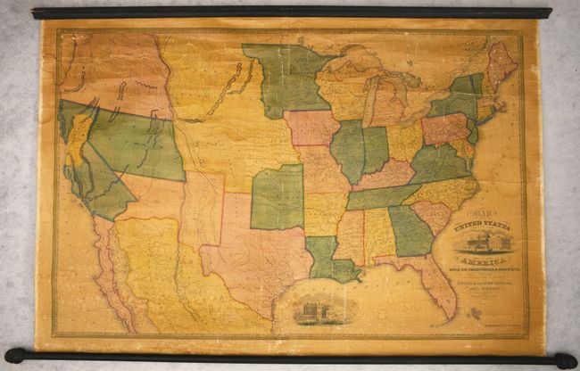
Auction 193, Lot 131
Subject: United States, Gold
Reed & Barber
Map of the United States of America with Its Territories & Districts, Including Also a Part of Upper & Lower Canada and Mexico, 1851
Size: 41 x 28 inches (104.1 x 71.1 cm)
Estimate: $2,400 - $3,000
Wall Map Featuring an Oversized California Gold Region
Sold for: $1,800
Closed on 6/21/2023

Auction 193, Lot 158
Subject: Eastern United States
Melish, John
United States of America Compiled from the Latest & Best Authorities, 1818
Size: 19.7 x 16.3 inches (50 x 41.4 cm)
Estimate: $2,000 - $2,300
Early & Separately Issued Version of Melish's Important Map
Sold for: $3,000
Closed on 6/21/2023

Auction 193, Lot 159
Subject: Eastern United States
Mitchell/Young
Map of the United States, 1831
Size: 35.4 x 44.9 inches (89.9 x 114 cm)
Estimate: $1,400 - $1,700
First Edition of Mitchell's Wall Map - His Inaugural Production
Sold for: $1,700
Closed on 6/21/2023

Auction 193, Lot 163
Subject: Colonial New England & Mid-Atlantic United States
Jansson, Jan
Nova Anglia Novum Belgium et Virginia, 1638
Size: 19.9 x 15.3 inches (50.5 x 38.9 cm)
Estimate: $1,200 - $1,500
Jansson's Influential Map of the East Coast
Sold for: $900
Closed on 6/21/2023

Auction 193, Lot 164
Subject: Colonial New England & Mid-Atlantic United States
Blaeu, Willem
Nova Belgica et Anglia Nova, 1640
Size: 19.7 x 15.3 inches (50 x 38.9 cm)
Estimate: $2,000 - $2,300
Important Map of Colonial New England and the Mid-Atlantic
Sold for: $2,500
Closed on 6/21/2023

Auction 193, Lot 165
Subject: Colonial New England & Mid-Atlantic United States
Allard, Hugo
Totius Neobelgii Nova et Accuratissima Tabula, 1674
Size: 21.3 x 18.4 inches (54.1 x 46.7 cm)
Estimate: $11,000 - $14,000
Exceedingly Rare 2nd State Known in only 2 Other Examples
Unsold
Closed on 6/21/2023

Auction 193, Lot 169
Subject: Colonial New England United States
Brion de la Tour, Louis
Carte du Theatre de la Guerre Entre les Anglais et les Americains: Dressee d'Apres les Cartes Anglaises les Plus Modernes, 1779
Size: 20.4 x 29.7 inches (51.8 x 75.4 cm)
Estimate: $3,500 - $4,250
Important Map Depicting Tipping Point of Revolutionary War
Sold for: $2,400
Closed on 6/21/2023

Auction 193, Lot 174
Subject: Colonial Mid-Atlantic United States
Homann, Johann Baptist
Virginia Marylandia et Carolina in America Septentrionali Britannorum Industria Excultae, 1730
Size: 22.8 x 19.1 inches (57.9 x 48.5 cm)
Estimate: $1,500 - $1,800
Map Created to Promote German Immigration to the New World
Sold for: $1,000
Closed on 6/21/2023
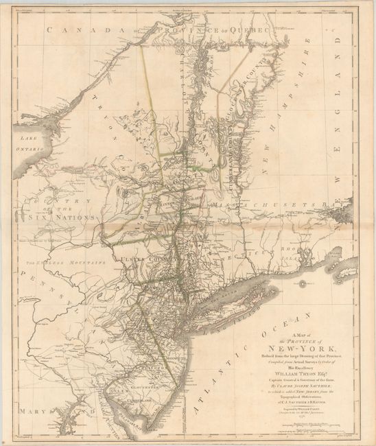
Auction 193, Lot 175
Subject: Colonial Mid-Atlantic United States, Revolutionary War
Sauthier/Faden
A Map of the Province of New-York, Reduc'd from the Large Drawing of That Province, Compiled from Actual Surveys by Order of His Excellency William Tryon Esqr..., 1776
Size: 22.6 x 28.1 inches (57.4 x 71.4 cm)
Estimate: $3,000 - $3,750
Important Revolutionary War Map Based on Sauthier and Ratzer
Unsold
Closed on 6/21/2023

Auction 193, Lot 181
Subject: Colonial Southeastern United States
Mercator/Hondius
Virginiae Item et Floridae Americae Provinciarum, Nova Descriptio, 1619
Size: 19.2 x 13.6 inches (48.8 x 34.5 cm)
Estimate: $1,500 - $1,800
A Seminal Map of the Southeast and Early American Cartography
Unsold
Closed on 6/21/2023

Auction 193, Lot 192
Subject: Central United States
Aa, Pieter van der
Land en Volk-Ontdekking in't Noorder Gedeelte van America, door P. Marquette en Joliet; Gedaan in't Jaar 1673, 1719
Size: 11.5 x 8.8 inches (29.2 x 22.4 cm)
Estimate: $1,000 - $1,300
Superb Map of Mississippi River Valley with Picture-Frame Style Border
Sold for: $750
Closed on 6/21/2023

Auction 193, Lot 203
Subject: Western United States, Railroads
Williams' New Trans-Continental Map of the Pacific R.R. and Routes of Overland Travel to Colorado, Nebraska, the Black Hills, Utah, Idaho, Nevada, Montana, California and the Pacific Coast, 1877
Size: 36.9 x 23.1 inches (93.7 x 58.7 cm)
Estimate: $800 - $950
Scarce Railroad Map by Henry Williams
Sold for: $500
Closed on 6/21/2023

Auction 193, Lot 209
Subject: Northwestern United States, Canada
Burr/Illman
Oregon Territory, 1833
Size: 12.8 x 10.6 inches (32.5 x 26.9 cm)
Estimate: $1,200 - $1,500
An Early Depiction of Oregon Territory
Sold for: $900
Closed on 6/21/2023
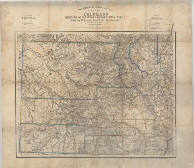
Auction 193, Lot 240
Subject: Colorado
Nell, Louis
Topographical & Township Map of Part of the State of Colorado Exhibiting the San Juan, Gunnison & California Mining Regions..., 1880
Size: 25.9 x 21.6 inches (65.8 x 54.9 cm)
Estimate: $2,000 - $2,300
Nell's First Map of Colorado
Sold for: $1,500
Closed on 6/21/2023

Auction 193, Lot 276
Subject: Colonial Saratoga, New York, Revolutionary War
Smith, Charles
Plan of the Position Which the Army Under Lt. Genl. Burgoine Took at Saratoga on the 10th of September 1777 and in Which It Remained Till the Convention Was Signed, 1796
Size: 13.8 x 8.4 inches (35.1 x 21.3 cm)
Estimate: $800 - $950
Rare Revolutionary War Map of the Second Battle of Saratoga
Sold for: $600
Closed on 6/21/2023

Auction 193, Lot 297
Subject: Hilton Head & South Carolina Coast
Jefferys & Faden
A Plan of the River and Sound of d'Awfoskee, in South Carolina. Survey'd by Captain John Gascoigne, 1776
Size: 17.9 x 25.3 inches (45.5 x 64.3 cm)
Estimate: $3,000 - $4,000
Rare Chart of Hilton Head
Sold for: $2,200
Closed on 6/21/2023
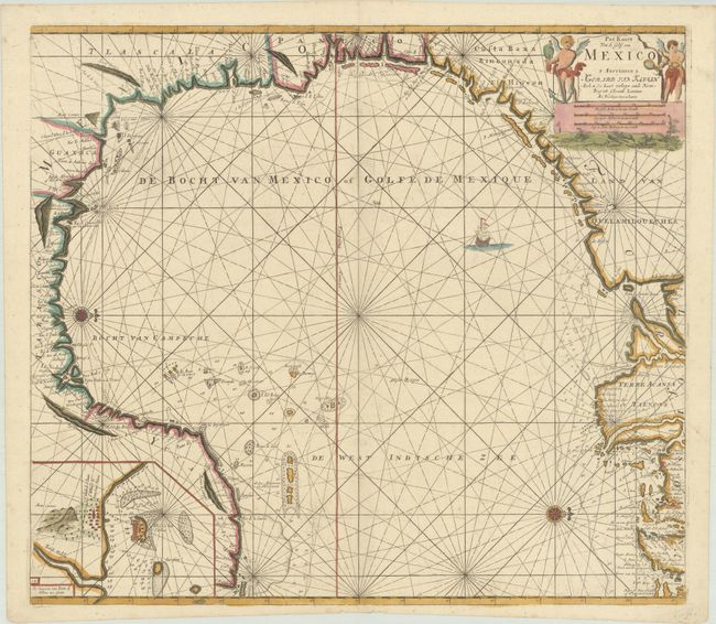
Auction 193, Lot 328
Subject: Gulf of Mexico
Keulen, Gerard van
Pas Kaart van de Golff van Mexico, 1734
Size: 23 x 20.3 inches (58.4 x 51.6 cm)
Estimate: $1,400 - $1,700
The First Sea Chart of the Western Portion of the Gulf of Mexico
Sold for: $1,000
Closed on 6/21/2023
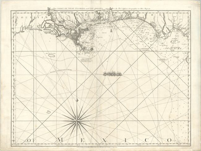
Auction 193, Lot 329
Subject: Gulf of Mexico
Jefferys/Laurie & Whittle
The Coast of West Florida and Louisiana, 1794
Size: 24.8 x 19.3 inches (63 x 49 cm)
Estimate: $1,100 - $1,400
Important 18th Century Map of Gulf Coast
Sold for: $550
Closed on 6/21/2023
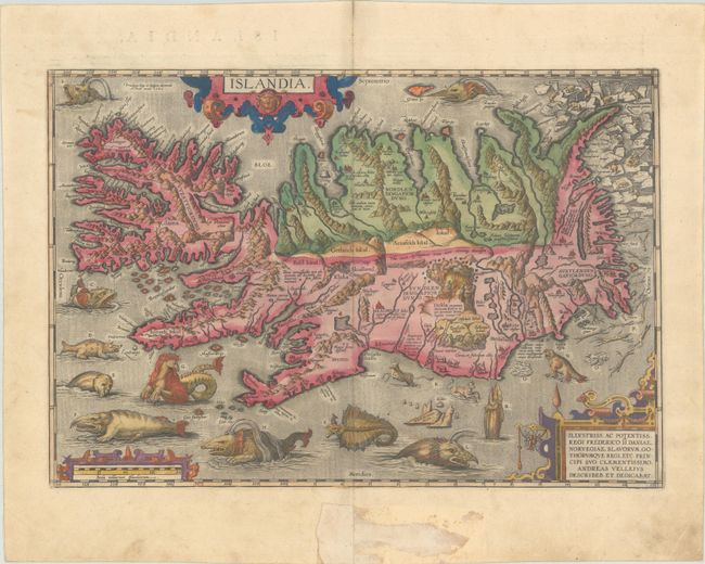
Auction 193, Lot 387
Subject: Iceland
Ortelius, Abraham
Islandia, 1585
Size: 19.4 x 13.3 inches (49.3 x 33.8 cm)
Estimate: $9,500 - $12,000
One of Ortelius' Most Decorative Maps in Full Contemporary Color
Unsold
Closed on 6/21/2023
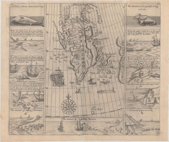
Auction 193, Lot 391
Subject: Spitsbergen
Purchas, Samuel
[Greneland], 1625
Size: 13.1 x 11.6 inches (33.3 x 29.5 cm)
Estimate: $950 - $1,200
Important Whaling Map of Spitsbergen
Sold for: $950
Closed on 6/21/2023
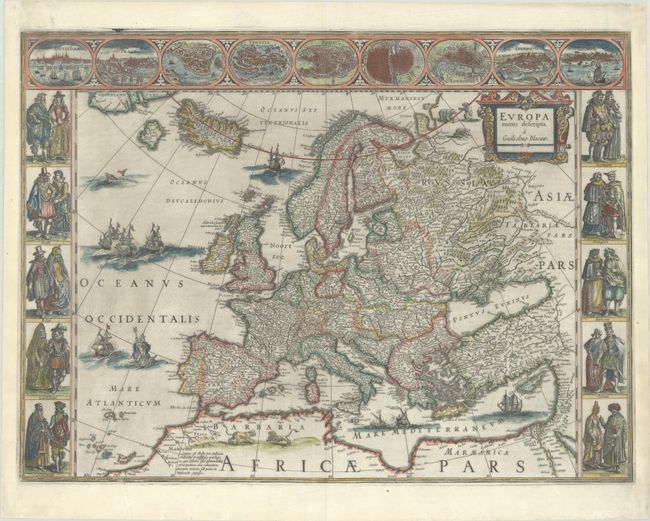
Auction 193, Lot 394
Subject: Europe
Blaeu, Willem
Europa Recens Descripta, 1643
Size: 22 x 16.3 inches (55.9 x 41.4 cm)
Estimate: $3,250 - $4,000
Blaeu's Carte-a-Figures Map of Europe
Unsold
Closed on 6/21/2023
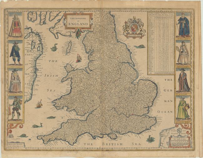
Auction 193, Lot 417
Subject: England & Wales
Speed, John
The Kingdome of England, 1646
Size: 20.4 x 15.3 inches (51.8 x 38.9 cm)
Estimate: $1,200 - $1,500
Speed's Carte-a-Figures Map of England and Wales
Unsold
Closed on 6/21/2023
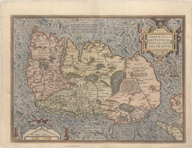
Auction 193, Lot 431
Subject: Ireland
Ortelius, Abraham
Eryn. Hiberniae, Britannicae Insulae, Nova Descriptio. Irlandt, 1598
Size: 19 x 14 inches (48.3 x 35.6 cm)
Estimate: $1,400 - $1,700
Ortelius' First Map of Ireland
Sold for: $1,000
Closed on 6/21/2023
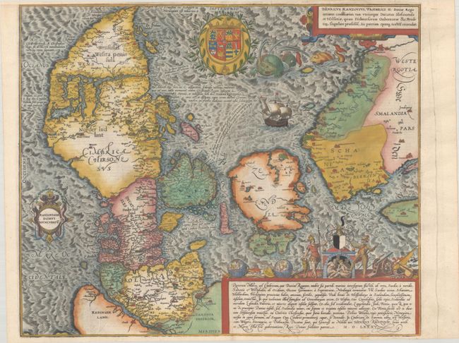
Auction 193, Lot 445
Subject: Denmark
Braun & Hogenberg
Danorum Marca, uel Cimbricum, aut Daniae Regnum..., 1585
Size: 18.1 x 15.1 inches (46 x 38.4 cm)
Estimate: $1,800 - $2,100
The Only Map in Braun and Hogenberg's Atlas of Town Views
Sold for: $1,000
Closed on 6/21/2023
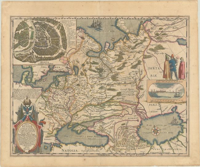
Auction 193, Lot 544
Subject: Russia in Europe
Blaeu, Willem
Tabula Russiae ex Autographo, quod Delineandum Curavit Foedor Filius Tzaris Boris Desumta ... M.DC.XIIII, 1644
Size: 21.4 x 16.8 inches (54.4 x 42.7 cm)
Estimate: $1,400 - $1,700
Blaeu's Decorative Map of Russia in Full Contemporary Color
Sold for: $1,000
Closed on 6/21/2023
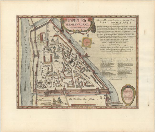
Auction 193, Lot 547
Subject: Moscow, Russia
Blaeu, Johannes
Kremlenagrad, Castellum Urbis Moskvae, 1662
Size: 19.2 x 14.8 inches (48.8 x 37.6 cm)
Estimate: $2,400 - $3,000
Superb Plan of the Walled Fortress of the Kremlin
Unsold
Closed on 6/21/2023
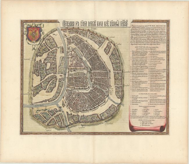
Auction 193, Lot 548
Subject: Moscow, Russia
Blaeu, Johannes
[Benevole Lector, in hac Tabula Urbis Moskvae…], 1662
Size: 19.3 x 14.8 inches (49 x 37.6 cm)
Estimate: $3,000 - $3,750
Scarce Map of Moscow with Title in Cyrillic
Unsold
Closed on 6/21/2023
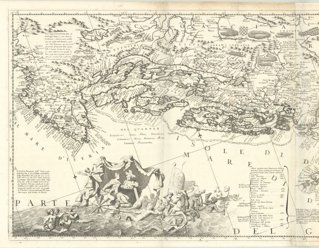
Auction 193, Lot 557
Subject: Western Balkans, Adriatic Sea
Coronelli, Vincenzo Maria
Ristretto della Dalmazia Divisa ne Suoi Contadi, gia Presentata alla Serenissima Republica di Venezia, etc., 1696-97
Size: 45 x 17.6 inches (114.3 x 44.7 cm)
Estimate: $1,500 - $1,800
Two-Sheet Map of Dalmatian Coast
Unsold
Closed on 6/21/2023
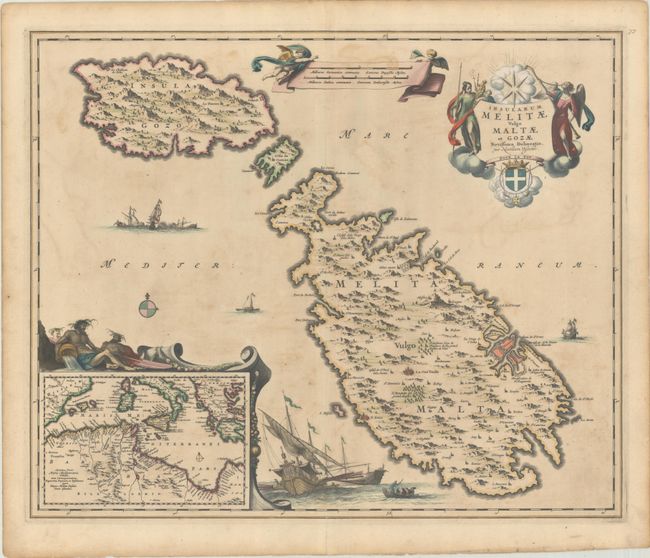
Auction 193, Lot 585
Subject: Malta
Visscher, Nicolas
Insularum Melitae Vulgo Maltae et Gozae Novissima Delineatio, 1680
Size: 22.2 x 18.1 inches (56.4 x 46 cm)
Estimate: $1,200 - $1,500
Highly Decorative 17th-Century Map of Malta
Unsold
Closed on 6/21/2023
Auction 193, Lot 589
Subject: Adriatic Sea & Ionian Sea
Bellin, Jacques Nicolas
Description Geographique du Golfe de Venise et de la Moree..., 1771
Size: 8.1 x 10.5 inches (20.6 x 26.7 cm)
Estimate: $1,900 - $2,200
Bellin's Complete Work on the Adriatic Sea and the Western Coasts of Greece
Sold for: $1,200
Closed on 6/21/2023
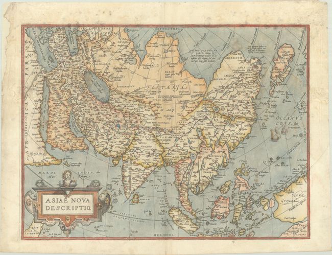
Auction 193, Lot 621
Subject: Asia
Ortelius, Abraham
Asiae Nova Descriptio, 1573
Size: 19.7 x 14.6 inches (50 x 37.1 cm)
Estimate: $1,100 - $1,400
Rare First Plate of Ortelius' Important Map of Asia
Sold for: $800
Closed on 6/21/2023
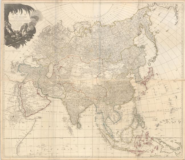
Auction 193, Lot 626
Subject: Asia
Laurie & Whittle
[On 4 Sheets] Asia and Its Islands According to D'Anville; Divided into Empires, Kingdoms, States, Regions, with the European Possessions and Settlements in the East Indies..., 1794
Size: 47.4 x 20.4 inches (120.4 x 51.8 cm)
Estimate: $1,800 - $2,200
Superb, Large-Scale English Map of Asia
Unsold
Closed on 6/21/2023
58 lots
Page 1 of 2