Filtered by Category:United States(Show All Categories)
Showing results for:Auction 97
Catalog Archive
139 lots
Page 1 of 3
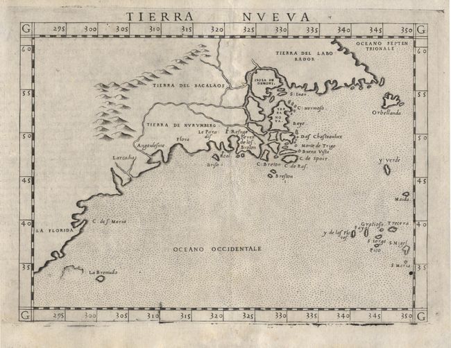
Auction 97, Lot 93
Subject: North America
Ruscelli, Girolamo
Tierra Nueva, 1574
Size: 9.6 x 7.1 inches (24.4 x 18 cm)
Estimate: $1,200 - $1,300
Sold for: $1,200
Closed on 12/5/2001

Auction 97, Lot 95
Subject: Colonial New England
Jansson, Jan
Nova Anglia Novum Belgium et Virginia, 1639-42
Size: 19.5 x 15 inches (49.5 x 38.1 cm)
Estimate: $2,750 - $3,000
Unsold
Closed on 12/5/2001
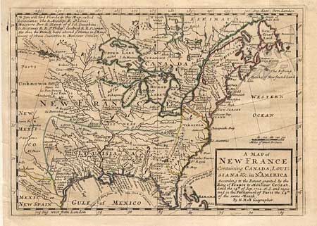
Auction 97, Lot 96
Subject: Colonial United States and Canada
Moll, Herman
A Map of New France Containing Canada, Louisiana &c. in Nth. America…, 1745
Size: 10.2 x 7.2 inches (25.9 x 18.3 cm)
Estimate: $450 - $500
Sold for: $325
Closed on 12/5/2001
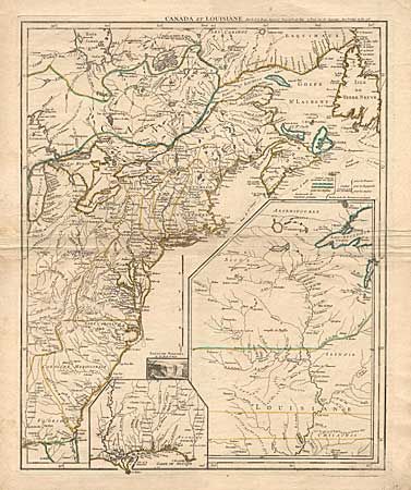
Auction 97, Lot 97
Subject: Colonial United States and Canada
Le Rouge, George Louis
Canada et Louisiane…, 1755
Size: 19.5 x 24 inches (49.5 x 61 cm)
Estimate: $3,000 - $3,500
Sold for: $2,200
Closed on 12/5/2001
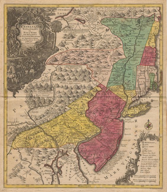
Auction 97, Lot 98
Subject: Colonial New England
Seutter/Lotter
Pensylvania Nova Jersey et Nova York cum Regionibus ad Fluvium Delaware in America sitis…, 1760
Size: 19.2 x 22.2 inches (48.8 x 56.4 cm)
Estimate: $2,500 - $2,750
Sold for: $1,800
Closed on 12/5/2001
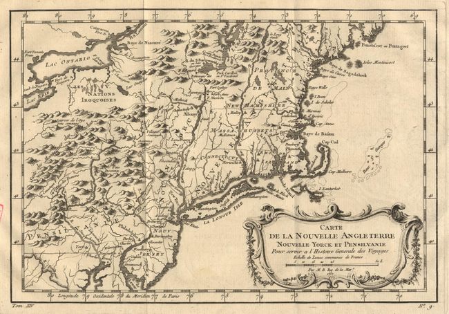
Auction 97, Lot 99
Subject: Colonial New England
Bellin, Jacques Nicolas
Carte de la Nouvelle Angleterre, Nouvelle Yorck et Pensilvanie, 1767
Size: 11.7 x 8.1 inches (29.7 x 20.6 cm)
Estimate: $375 - $425
Sold for: $375
Closed on 12/5/2001
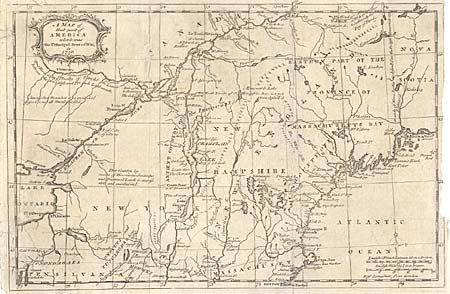
Auction 97, Lot 100
Subject: Colonial New England
Anon.
A Map of that part of America which was the Principal Seat of War, in 1756, 1756
Size: 13 x 8.5 inches (33 x 21.6 cm)
Estimate: $100 - $150
Sold for: $100
Closed on 12/5/2001
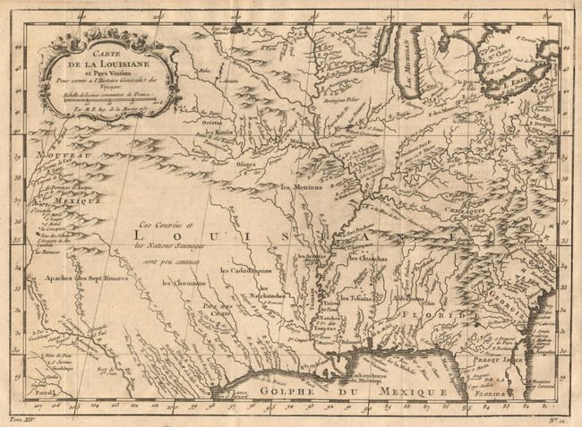
Auction 97, Lot 101
Subject: Colonial Central United States
Bellin, Jacques Nicolas
Carte de la Louisiane et Pays Voisins Pour servir a l'Histoire Generale des Voyages, 1757
Size: 12 x 8.8 inches (30.5 x 22.4 cm)
Estimate: $275 - $325
Sold for: $350
Closed on 12/5/2001
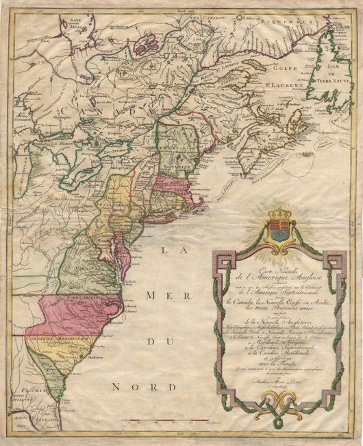
Auction 97, Lot 102
Subject: Colonial North America
Lotter, Mathias Albrecht
Carte Nouvelle de l'Amerique Angloise contenant tout ce que Anglois possedent sur le Continent de l'Amerique Septentrionale Savoir le Canada, la Nouvelle Ecosse ou Acadie, les treize Provinces unies.., 1776
Size: 19.2 x 23.7 inches (48.8 x 60.2 cm)
Estimate: $800 - $1,000
Sold for: $800
Closed on 12/5/2001
Auction 97, Lot 103
Subject: Colonial Midwest
Gibson, John
[Map of the Mississippi River Valley], 1763
Size: 9.3 x 7.1 inches (23.6 x 18 cm)
Estimate: $300 - $350
Sold for: $220
Closed on 12/5/2001
Auction 97, Lot 104
Subject: Colonial Mid Atlantic
Sayer & Bennett
[The Provinces of New York, and New Jersey; with part of Pennsylvania, and the Province of Quebec], 1775
Size: 20.5 x 26.3 inches (52.1 x 66.8 cm)
Estimate: $500 - $600
Sold for: $375
Closed on 12/5/2001

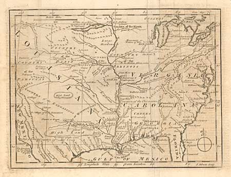
Auction 97, Lot 105
Subject: Colonial New York
Faden, William
A Plan of New York Island with part of Long Island, Staten Island & East New Jersey, with a particular Description of the Engagement on the Woody Heights of Long Island … on the 27th of August 1776, 1776
Size: 16.6 x 18.6 inches (42.2 x 47.2 cm)
Estimate: $4,500 - $5,500
Unsold
Closed on 12/5/2001
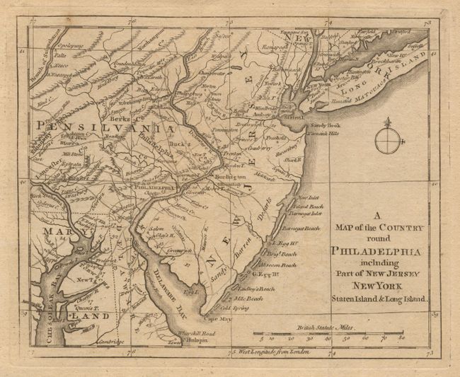
Auction 97, Lot 106
Subject: Colonial Mid-Atlantic
Anon.
A Map of the Country round Philadelphia including Part of New Jersey, New York, Staten Island & Long Island, 1776
Size: 8.8 x 7 inches (22.4 x 17.8 cm)
Estimate: $200 - $250
Sold for: $200
Closed on 12/5/2001
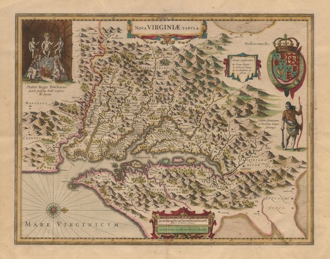
Auction 97, Lot 107
Subject: Colonial Southeast
Hondius, Henricus
Nova Virginiae Tabula, 1665
Size: 19.5 x 15 inches (49.5 x 38.1 cm)
Estimate: $2,300 - $2,500
Sold for: $2,300
Closed on 12/5/2001
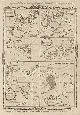
Auction 97, Lot 108
Subject: Colonial North America
Conder, Thomas
Various Plans and Draughts of Cities, Towns, Harbours &c. Drawn from the latest Authorities, 1782
Size: 8.3 x 12 inches (21.1 x 30.5 cm)
Estimate: $200 - $250
Sold for: $230
Closed on 12/5/2001
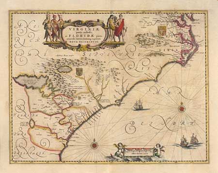
Auction 97, Lot 109
Subject: Colonial Southeast
Jansson, Jan
Virginiae partis australis, et Floridae partis orientalis, interjacentiumq regionum Nova Descriptio, 1665
Size: 19.5 x 15.2 inches (49.5 x 38.6 cm)
Estimate: $1,900 - $2,000
Sold for: $1,600
Closed on 12/5/2001
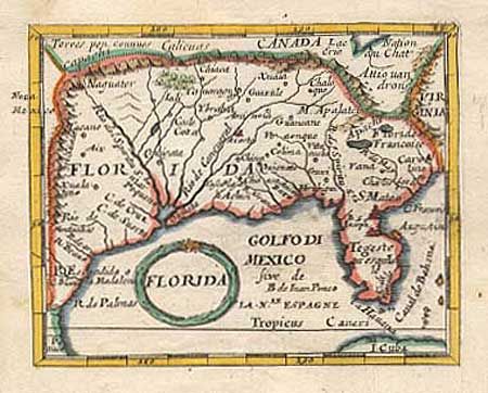
Auction 97, Lot 110
Subject: Colonial South
Beer, Johann Christoph
Florida, 1678-90
Size: 4.6 x 3.7 inches (11.7 x 9.4 cm)
Estimate: $400 - $450
Sold for: $350
Closed on 12/5/2001
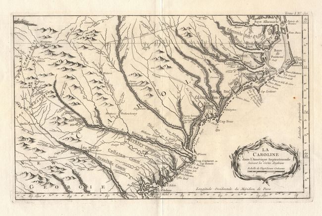
Auction 97, Lot 111
Subject: Colonial Southeast
Bellin, Jacques Nicolas
La Caroline dans l'Amerique Septentrionale Suivant les Cartes Angloises, 1764
Size: 14 x 8.8 inches (35.6 x 22.4 cm)
Estimate: $350 - $450
Sold for: $300
Closed on 12/5/2001
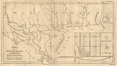
Auction 97, Lot 112
Subject: Colonial South
Lodge, John
A Map of Part of West Florida, from Pensacola to the Mouth of the Iberville River, with a View to shew the proper Spot for a Settlement on the Mississipi, 1772
Size: 13.3 x 7.4 inches (33.8 x 18.8 cm)
Estimate: $150 - $180
Sold for: $110
Closed on 12/5/2001

Auction 97, Lot 114
Subject: Colonial United States and Canada - Great Lakes
Delisle/Covens & Mortier
Carte Du Canada ou de la Nouvelle France et des decouvertes qui y ont ete faites Dressee sur plusieurs Observations et sur un grand nombre de Ralations imprimees ou manuscrites, 1730
Size: 22.6 x 19.3 inches (57.4 x 49 cm)
Estimate: $800 - $900
Sold for: $800
Closed on 12/5/2001

Auction 97, Lot 116
Subject: Canada
Bellin, Jacques Nicolas
Suite du Cours du Fleuve de St. Laurent depuis Quebec jusqu'au Lac Ontario, 1757
Size: 11.3 x 7.5 inches (28.7 x 19.1 cm)
Estimate: $230 - $275
Sold for: $150
Closed on 12/5/2001
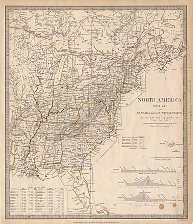
Auction 97, Lot 124
Subject: Eastern United States and Canada
SDUK Society for the Diffusion of Useful Knowledge
North America Index Map to Canada and the United States, 1834
Size: 12.5 x 14.5 inches (31.8 x 36.8 cm)
Estimate: $100 - $140
Sold for: $90
Closed on 12/5/2001
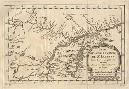
Auction 97, Lot 125
Subject: Canada & New York
Bellin, Jacques Nicolas
Suite du Cours du Fleuve de St. Laurent depuis Quebec jusqu'au Lac Ontario, 1757
Size: 11.2 x 7.5 inches (28.4 x 19.1 cm)
Estimate: $150 - $180
Sold for: $230
Closed on 12/5/2001
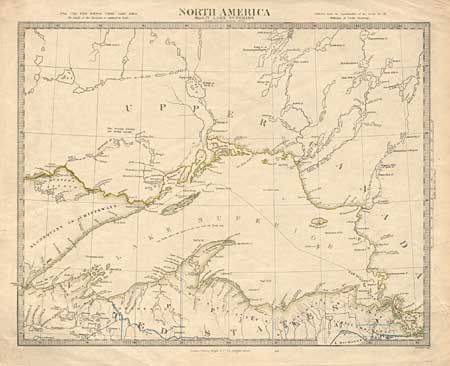
Auction 97, Lot 126
Subject: United States and Canada
SDUK Society for the Diffusion of Useful Knowledge
North America Sheet IV Lake Superior, 1840
Size: 15.2 x 12 inches (38.6 x 30.5 cm)
Estimate: $100 - $150
Sold for: $75
Closed on 12/5/2001
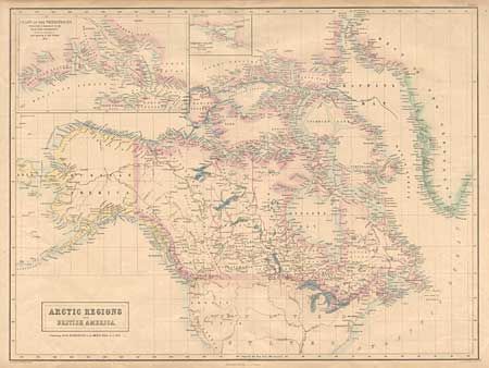
Auction 97, Lot 127
Subject: Canada and Arctic
Bartholomew, John
Arctic Regions and British America. Containing all the Discoveries in the Arctic Seas up to 1853, 1854
Size: 21.7 x 16.3 inches (55.1 x 41.4 cm)
Estimate: $130 - $160
Sold for: $80
Closed on 12/5/2001
Auction 97, Lot 128
Subject: Northwestern United States and Canada
U.S. Coast Survey
Strait of Juan de Fuca and the channels between the Continent and Vancouver Id. showing the boundary line between British and American Possessions, 1872
Size: 43 x 29 inches (109.2 x 73.7 cm)
Estimate: $300 - $400
Sold for: $275
Closed on 12/5/2001
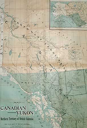
Auction 97, Lot 129
Subject: Canada and Alaska
Anon.
Map of the Canadian Yukon and Northern Territory of British Columbia, 1897
Size: 26.5 x 38.5 inches (67.3 x 97.8 cm)
Estimate: $170 - $200
Sold for: $120
Closed on 12/5/2001
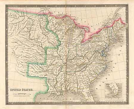
Auction 97, Lot 130
Subject: United States
Teesdale, Henry
United States, 1837
Size: 16.1 x 13.1 inches (40.9 x 33.3 cm)
Estimate: $150 - $200
Sold for: $110
Closed on 12/5/2001
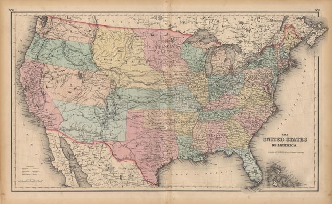
Auction 97, Lot 131
Subject: United States
Colton, Joseph Hutchins
The United States of America, 1855
Size: 25 x 14.6 inches (63.5 x 37.1 cm)
Estimate: $300 - $350
Sold for: $240
Closed on 12/5/2001
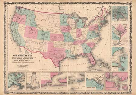
Auction 97, Lot 132
Subject: United States
Johnson and Ward
Johnson's New Military Map of the United States Showing the Forts, Military Posts &c. all the Military Divisions with Enlarged Plans of Southern Harbors…, 1861
Size: 23.5 x 17 inches (59.7 x 43.2 cm)
Estimate: $200 - $250
Sold for: $275
Closed on 12/5/2001
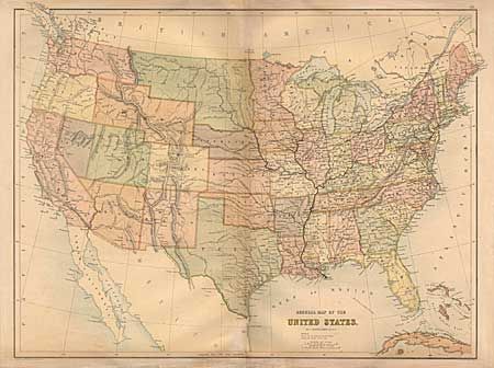
Auction 97, Lot 133
Subject: United States
Bartholomew, John
General Map of the United States, 1863
Size: 21.5 x 16.2 inches (54.6 x 41.1 cm)
Estimate: $170 - $200
Sold for: $110
Closed on 12/5/2001
Auction 97, Lot 134
Subject: United States
General Land Office
Map of the Public Land States and Territories constructed from The Public Surveys and other official sources in the General Land Office, 1865
Size: 44.2 x 28.1 inches (112.3 x 71.4 cm)
Estimate: $220 - $275
Sold for: $110
Closed on 12/5/2001

Auction 97, Lot 135
Subject: United States
Philip, George
The Pacific States, The Territories and a portion of the North-Western States, 1865
Size: 23.8 x 19.7 inches (60.5 x 50 cm)
Estimate: $140 - $170
Unsold
Closed on 12/5/2001
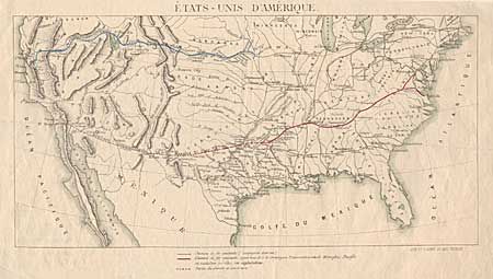
Auction 97, Lot 136
Subject: United States
Various
Etats-Unis d'Amerique [together with] Map showing the divisions of Standard Time, 1869-83
Size: See Description
Estimate: $80 - $100
Sold for: $65
Closed on 12/5/2001
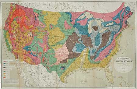
Auction 97, Lot 137
Subject: United States
Hitchcock, Charles Henry
Geological Map of the United States, 1873
Size: 33.2 x 21.2 inches (84.3 x 53.8 cm)
Estimate: $220 - $300
Sold for: $300
Closed on 12/5/2001
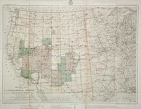
Auction 97, Lot 138
Subject: United States
U.S. Corps of Engineers
1878, Progress Map of the U.S. Geographical Surveys West of the 100th Meridian to accompany the special report of 1st Lt. George M. Wheeler, 1878
Size: 22.2 x 16 inches (56.4 x 40.6 cm)
Estimate: $100 - $120
Sold for: $70
Closed on 12/5/2001
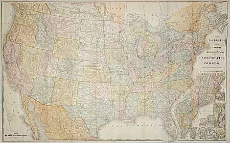
Auction 97, Lot 139
Subject: United States
Rand McNally & Co.
New Official Railroad Map of the United States and Canada, 1885
Size: 42.5 x 26.5 inches (108 x 67.3 cm)
Estimate: $250 - $300
Sold for: $300
Closed on 12/5/2001
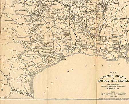
Auction 97, Lot 140
Subject: United States
[Set of twelve maps] RailWay Mail Service, 1906
Size: See Description
Estimate: $120 - $150
Sold for: $220
Closed on 12/5/2001

Auction 97, Lot 141
Subject: Colonial Mid-Atlantic and Southeast
Sartine
Carte Reduite des Cotes Orientales de l'Amerique Septentrionale Contenant Partie du Nouveau Jersey, la Pen-sylvanie, le Mary-land, la Virginie, la Caroline Septetrionale, la Caroline Meridonale et la Georgie, 1799
Size: 33.5 x 22.6 inches (85.1 x 57.4 cm)
Estimate: $1,900 - $2,000
Unsold
Closed on 12/5/2001
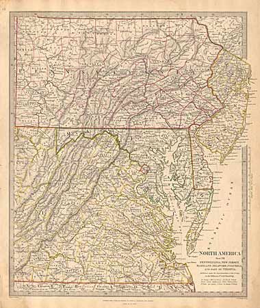
Auction 97, Lot 142
Subject: Eastern United States
SDUK Society for the Diffusion of Useful Knowledge
North America Sheet VII - Pennsylvania, New Jersey, Maryland, Delaware, Columbia and part of Virginia, 1833
Size: 12.3 x 14.7 inches (31.2 x 37.3 cm)
Estimate: $50 - $60
Sold for: $55
Closed on 12/5/2001
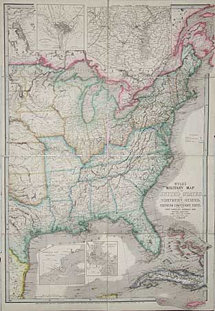
Auction 97, Lot 143
Subject: Southeastern United States
Wyld, James
Wyld's Military Map of the United States and the Southern Confederate States with the Forts, Harbours, Arsenals and Military Positions, 1861
Size: 23 x 33 inches (58.4 x 83.8 cm)
Estimate: $400 - $600
Sold for: $750
Closed on 12/5/2001
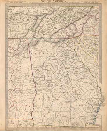
Auction 97, Lot 144
Subject: Southern United States
SDUK Society for the Diffusion of Useful Knowledge
North America Sheet XII Georgia with parts of North & South Carolina, Tennessee, Alabama & Florida, 1833
Size: 12 x 15.7 inches (30.5 x 39.9 cm)
Estimate: $60 - $80
Sold for: $65
Closed on 12/5/2001
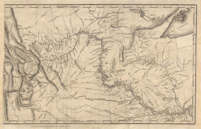
Auction 97, Lot 145
Subject: Central United States
Lewis & Clark
[A Map of Lewis & Clarks track across the western portion of North America…], 1814
Size: 18.7 x 11.7 inches (47.5 x 29.7 cm)
Estimate: $500 - $600
Sold for: $900
Closed on 12/5/2001
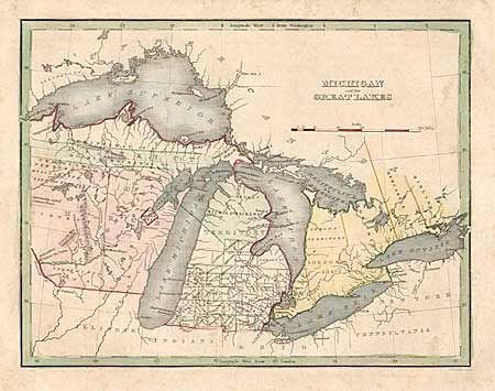
Auction 97, Lot 146
Subject: Great Lakes
Bradford, Thomas Gamaliel
Michigan and the Great Lakes, 1835
Size: 10 x 7.8 inches (25.4 x 19.8 cm)
Estimate: $120 - $150
Sold for: $210
Closed on 12/5/2001
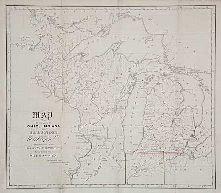
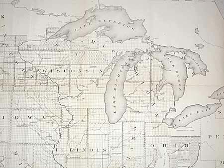
Auction 97, Lot 147
Subject: Central United States
Burr, David H.
Map of the Northern parts of Ohio, Indiana and Illinois with Michigan and that part to the Ouisconsin Territory Lying East of the Mississippi River, 1838
Size: 14.7 x 12.9 inches (37.3 x 32.8 cm)
Estimate: $150 - $200
Sold for: $160
Closed on 12/5/2001
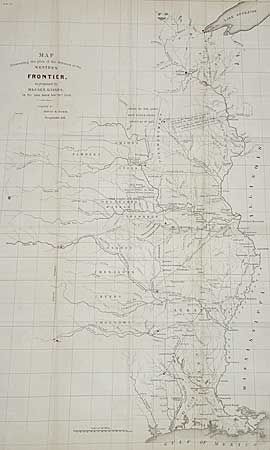
Auction 97, Lot 148
Subject: Central United States
Burr, David H.
Map Illustrating the plan of the defences of the Western Frontier, as proposed by Maj. Gen. Gaines, in his plan dated Feby. 28th 1838, 1838
Size: 14.2 x 23.5 inches (36.1 x 59.7 cm)
Estimate: $300 - $350
Sold for: $220
Closed on 12/5/2001
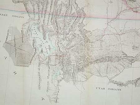
Auction 97, Lot 149
Subject: Central United States
Stansbury, M. Howard (Capt.)
Map of a Reconnaissance between Fort Leavenworth on the Missouri River, and the Great Salt Lake in the Territory of Utah, made in 1849 and 1850…, 1852
Size: 66 x 28 inches (167.6 x 71.1 cm)
Estimate: $425 - $475
Sold for: $425
Closed on 12/5/2001
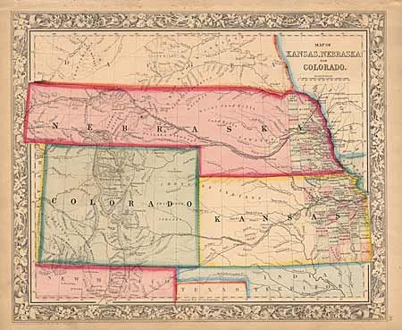
Auction 97, Lot 150
Subject: Central United States
Mitchell, Samuel Augustus
Map of Kansas, Nebraska and Colorado, 1860
Size: 14 x 11.3 inches (35.6 x 28.7 cm)
Estimate: $200 - $250
Sold for: $250
Closed on 12/5/2001
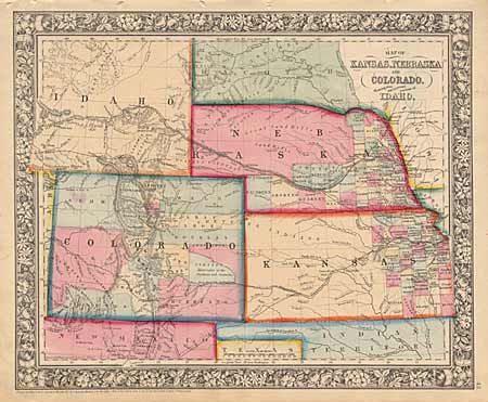
Auction 97, Lot 151
Subject: Central United States
Mitchell, Samuel Augustus
Map of Kansas, Nebraska and Colorado, Showing also the Eastern Portion of Idaho, 1861
Size: 14 x 11.5 inches (35.6 x 29.2 cm)
Estimate: $120 - $180
Sold for: $120
Closed on 12/5/2001
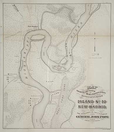
Auction 97, Lot 152
Subject: Missouri and Tennessee
U.S. War Dept.
Map Showing the System of Rebel Fortifications on the Mississippi River at Island No. 10 and New Madrid Also the Operations of the U.S. Forces under General John Pope Against these Positions, 1866
Size: 17.2 x 20 inches (43.7 x 50.8 cm)
Estimate: $150 - $200
Sold for: $140
Closed on 12/5/2001
139 lots
Page 1 of 3