Filtered by Category:United States(Show All Categories)
Showing results for:Auction 160
Catalog Archive
230 lots
Page 1 of 5
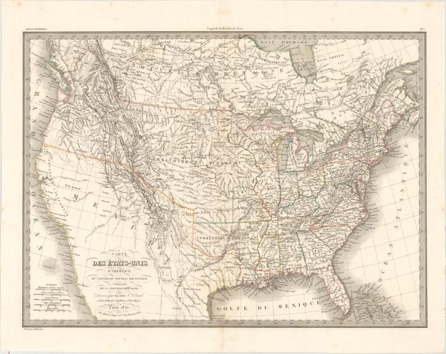
Auction 160, Lot 131
Subject: Canada & United States
Lapie, Alexander Emile & Pierre
Carte des Etats-Unis d'Amerique, du Canada, du Nouveau Brunswick et d'une Partie de la Nouvelle Bretagne, 1832
Size: 21.3 x 15.5 inches (54.1 x 39.4 cm)
Estimate: $300 - $375
Sold for: $220
Closed on 11/16/2016
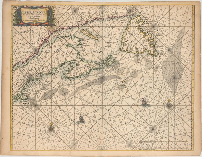
Auction 160, Lot 132
Subject: Canadian Maritimes & New England
Loon, Jan van
Pas-caerte van Terra Nova, Nova Francia, Nieuw Engeland en de Grote Rivier van Canada, 1666
Size: 21.2 x 16.8 inches (53.8 x 42.7 cm)
Estimate: $3,500 - $4,500
Very Influential Dutch Sea Chart of the Canadian Maritimes
Sold for: $1,900
Closed on 11/16/2016

Auction 160, Lot 133
Subject: Colonial Northeastern United States & Canada
Duval, Pierre
Canada, 1682
Size: 4.8 x 3.8 inches (12.2 x 9.7 cm)
Estimate: $400 - $475
Sold for: $260
Closed on 11/16/2016
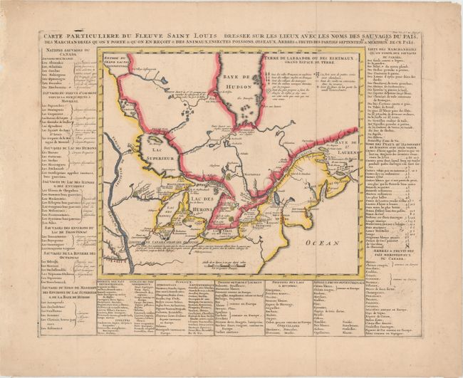
Auction 160, Lot 134
Subject: Colonial Northeastern United States & Canada, Great Lakes
Chatelain, Henry Abraham
Carte Particuliere du Fleuve Saint Louis Dressee sur les Lieux avec les Noms des Sauvages du Pais... , 1719
Size: 18 x 14.3 inches (45.7 x 36.3 cm)
Estimate: $800 - $1,000
Sold for: $550
Closed on 11/16/2016

Auction 160, Lot 135
Subject: Colonial Northeastern United States & Canada, Great Lakes
Robert de Vaugondy, Didier
Partie de l'Amerique Septent? qui Comprend la Nouvelle France ou le Canada, 1755
Size: 23.8 x 19 inches (60.5 x 48.3 cm)
Estimate: $600 - $750
Sold for: $400
Closed on 11/16/2016
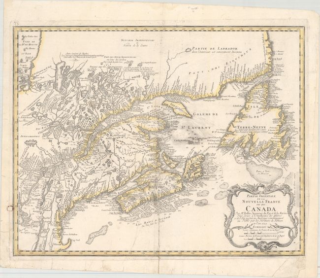
Auction 160, Lot 136
Subject: Colonial Northeastern United States & Canada
Bellin/Homann Heirs
Partie Orientale de la Nouvelle France ou du Canada, 1755
Size: 21.1 x 16.9 inches (53.6 x 42.9 cm)
Estimate: $800 - $950
Sold for: $440
Closed on 11/16/2016
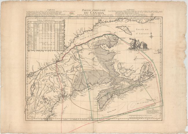
Auction 160, Lot 137
Subject: Colonial Northeastern United States & Canada
Le Rouge, George Louis
Partie Orientale du Canada Traduitte de l'Anglois de la Carte de Jefferys Publiee a Londres..., 1755
Size: 24.1 x 18.6 inches (61.2 x 47.2 cm)
Estimate: $950 - $1,200
Map Depicting French and British Claims in the Canadian Maritimes
Sold for: $600
Closed on 11/16/2016
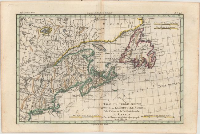
Auction 160, Lot 138
Subject: Colonial Northeastern United States & Canada
[Lot of 2] L'Isle de Terre-Neuve, l'Acadie, ou la Nouvelle Ecosse, l'Isle St Jean et la Partie Orientale du Canada [and] British North America Sheet 1, East. Newfoundland, New Brunswick, Nova Scotia, Prince Edward Island &c., 1775-1872
Size: See Description
Estimate: $200 - $230
NO RESERVE
Sold for: $110
Closed on 11/16/2016
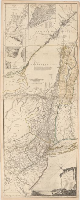
Auction 160, Lot 139
Subject: Colonial Northeastern United States & Quebec
Holland/Pownal
The Provinces of New York and New Jersey; with Part of Pensilvania, and the Province of Quebec, 1776
Size: 21.3 x 52.9 inches (54.1 x 134.4 cm)
Estimate: $5,500 - $7,000
Thomas Jefferys' Important Revolutionary War Period Map
Sold for: $3,500
Closed on 11/16/2016
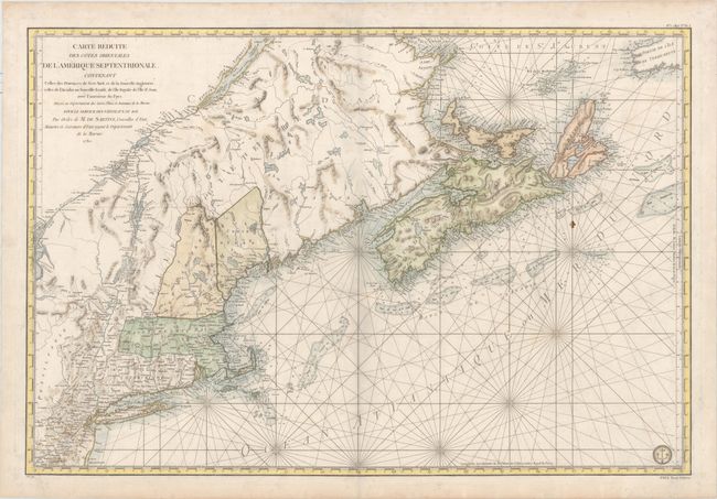
Auction 160, Lot 140
Subject: Colonial Northeastern United States & Canada
Sartine
Carte Reduite des Cotes Orientales de l'Amerique Septentrionale. Contenant Celles des Provinces de New-York et de la Nouvelle Angleterre, Celles de l'Acadie ou Nouvelle Ecosse..., 1780
Size: 33.8 x 22.9 inches (85.9 x 58.2 cm)
Estimate: $1,000 - $1,300
Sold for: $600
Closed on 11/16/2016

Auction 160, Lot 141
Subject: Northeastern United States & Canada
Depot de la Marine
Carte de la Cote Orientale de l'Amerique Septentrionale Partie Comprise Entre la Baie de Gaspee et New York..., 1834
Size: 34.3 x 23 inches (87.1 x 58.4 cm)
Estimate: $700 - $850
Unsold
Closed on 11/16/2016
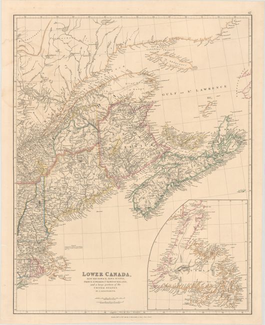
Auction 160, Lot 142
Subject: Northeastern United States & Canada
Arrowsmith, John
Lower Canada, New Brunswick, Nova Scotia, Prince Edwards Id. Newfoundland, and a Large Portion of the United States, 1838
Size: 19 x 23.8 inches (48.3 x 60.5 cm)
Estimate: $200 - $230
Unsold
Closed on 11/16/2016

Auction 160, Lot 143
Subject: Northeastern United States & Canada
Hall, Sidney
British Possessions in North America, with Part of the United States, Compiled from Official Sources, 1840
Size: 25.4 x 14.1 inches (64.5 x 35.8 cm)
Estimate: $100 - $130
Sold for: $75
Closed on 11/16/2016
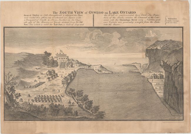
Auction 160, Lot 144
Subject: Colonial Northeastern United States & Canada, Great Lakes
[Lot of 3] The South View of Oswego on Lake Ontario... [and] Map of the Frontiers of the Northern Colonies with the Boundary Line Established Between Them and the Indians at the Treaty... [and] Carte des Frontieres Francoises..., 1850
Size: See Description
Estimate: $100 - $130
NO RESERVE
Sold for: $45
Closed on 11/16/2016
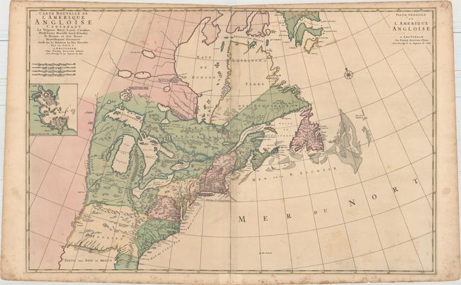
Auction 160, Lot 145
Subject: Colonial Eastern United States & Canada
Mortier, Pierre
Carte Nouvelle de l'Amerique Angloise Contenant la Virginie, Mary-Land, Caroline, Pensylvania Nouvelle Iorck, N: Iarsey N: France, et les Terres Nouvellement Decouerte..., 1700
Size: 35.8 x 23.4 inches (90.9 x 59.4 cm)
Estimate: $2,000 - $2,300
A Map Showing Fascinating Geographic Misconceptions
Sold for: $1,200
Closed on 11/16/2016
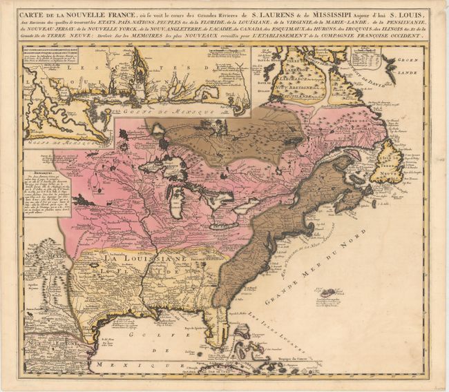
Auction 160, Lot 146
Subject: Colonial Eastern United States & Canada
Ottens/De Fer
Carte de la Nouvelle France, ou se Voit le Cours des Grandes Rivieres de S. Laurens & de Mississipi Aujour d'hui S. Louis, aux Environs des-quelles se Trouvent les Etats, Pais, Nations, Peuples &c..., 1719
Size: 21.5 x 19.5 inches (54.6 x 49.5 cm)
Estimate: $2,300 - $2,750
Reduced Version of De Fer's Influential Map of French Possessions in North America
Sold for: $1,700
Closed on 11/16/2016
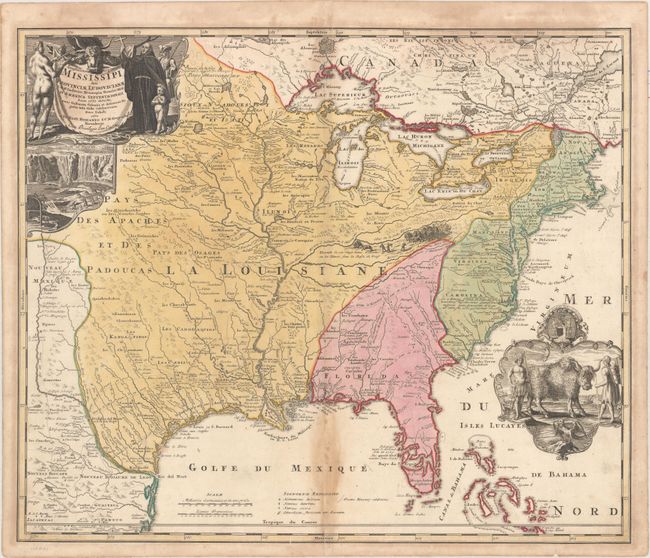
Auction 160, Lot 147
Subject: Colonial Eastern United States & Canada
Homann, Johann Baptist
Amplissimae Regionis Mississipi seu Provinciae Ludovicianae a R.P. Ludovico Hennepin Francisc Miss in America Septentrionali Anno 1687..., 1720
Size: 22.6 x 19.1 inches (57.4 x 48.5 cm)
Estimate: $1,700 - $2,000
Striking Map of Colonial America with Buffalo Vignette
Sold for: $1,400
Closed on 11/16/2016
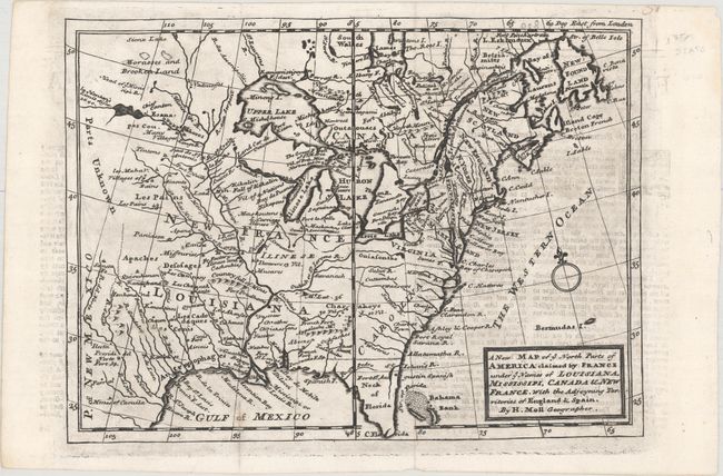
Auction 160, Lot 148
Subject: Colonial Eastern United States & Canada
Moll, Herman
A New Map of ye North Parts of America Claimed by France under ye Names of Louisiana, Mississipi, Canada & New France, with the Adjoyning Territories of England & Spain, 1735
Size: 10.8 x 7.8 inches (27.4 x 19.8 cm)
Estimate: $400 - $500
Sold for: $300
Closed on 11/16/2016

Auction 160, Lot 149
Subject: Colonial Eastern United States & Canada
Homann Heirs
America Septentrionalis a Domino d'Anville in Galliis Edita nunc in Anglia Coloniis in Interiorem Virginiam Deductis nec non Fluvii Ohio Cursu..., 1777
Size: 20 x 18.1 inches (50.8 x 46 cm)
Estimate: $600 - $750
Sold for: $400
Closed on 11/16/2016
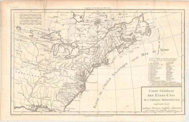
Auction 160, Lot 150
Subject: Eastern United States & Canada
Crevecoeur, Michel Guillaume De
Carte Generale des Etats-Unis de l'Amerique Septentrionale, Renfermant Aussi Quelques Provinces Angloises Adjacentes..., 1787
Size: 16.7 x 10.1 inches (42.4 x 25.7 cm)
Estimate: $800 - $1,000
One of the Earliest Maps to Name Franklinia
Sold for: $600
Closed on 11/16/2016
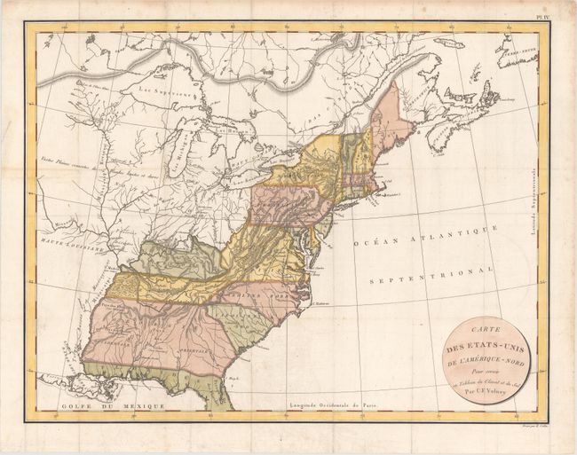
Auction 160, Lot 151
Subject: Eastern United States & Canada
Volney, C. F.
Carte des Etats-Unis de l'Amerique-Nord pour Servir au Tableau du Climat et du Sol, 1803
Size: 22.2 x 17.1 inches (56.4 x 43.4 cm)
Estimate: $210 - $240
Sold for: $140
Closed on 11/16/2016

Auction 160, Lot 152
Subject: Colonial Great Lakes
Bellin, Jacques Nicolas
Carte des Lacs du Canada pour Servir a l'Histoire Generale des Voyages, 1757
Size: 11.5 x 7.8 inches (29.2 x 19.8 cm)
Estimate: $350 - $425
Sold for: $190
Closed on 11/16/2016
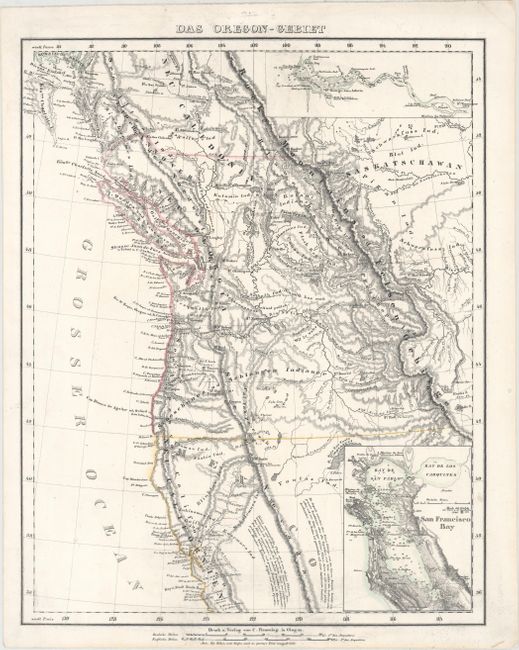
Auction 160, Lot 153
Subject: Western United States & Canada
Flemming, Carl
Das Oregon-Gebiet, 1848
Size: 12.6 x 15.8 inches (32 x 40.1 cm)
Estimate: $220 - $250
Sold for: $170
Closed on 11/16/2016
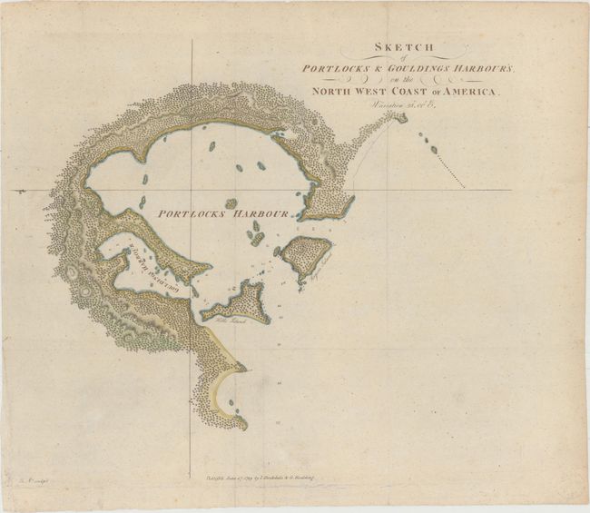
Auction 160, Lot 154
Subject: Alaska, Nootka Sound
[Lot of 2] Sketch of Portlocks & Gouldings Harbour's, on the North West Coast of America [and] Sketch of Nootka Sound, 1778-89
Size: See Description
Estimate: $300 - $400
NO RESERVE
Sold for: $55
Closed on 11/16/2016

Auction 160, Lot 155
Subject: United States
Vivien de Saint Martin, Louis
Carte Generale des Etats Unis de l'Amerique Septentrionale, 1825
Size: 16.1 x 12.3 inches (40.9 x 31.2 cm)
Estimate: $200 - $230
Sold for: $150
Closed on 11/16/2016
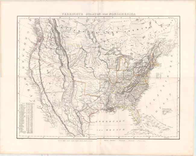
Auction 160, Lot 156
Subject: United States
Flemming, Carl
Vereinigte Staaten von Nordamerika, 1845
Size: 27.3 x 20.4 inches (69.3 x 51.8 cm)
Estimate: $275 - $350
Sold for: $325
Closed on 11/16/2016

Auction 160, Lot 157
Subject: United States, Railroads
Throop, O. H.
[Untitled - Map of Proposed Routes of Western Railroads], 1848
Size: 16 x 9.5 inches (40.6 x 24.1 cm)
Estimate: $200 - $250
Sold for: $120
Closed on 11/16/2016
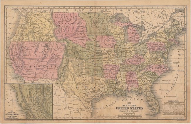
Auction 160, Lot 158
Subject: United States
Mitchell, Samuel Augustus
No. 5 Map of the United States Engraved to Illustrate Mitchell's School and Family Geography, 1849
Size: 16.7 x 10.5 inches (42.4 x 26.7 cm)
Estimate: $180 - $220
Sold for: $210
Closed on 11/16/2016
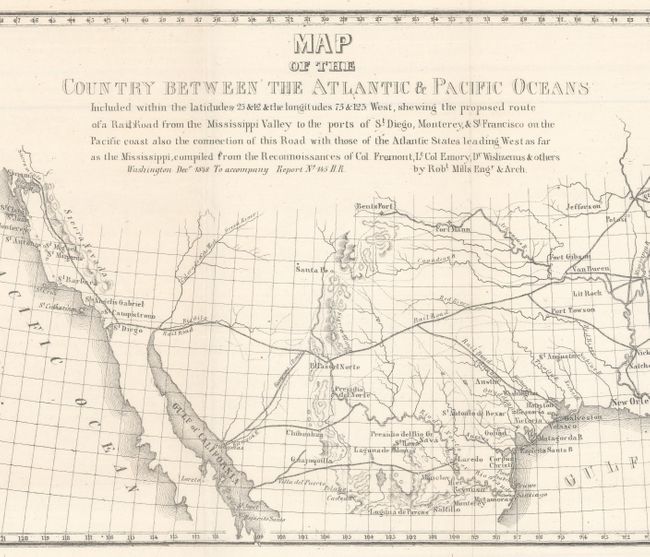
Auction 160, Lot 159
Subject: United States
Mills, Robert
Map of the Country Between the Atlantic & Pacific Oceans..., 1852
Size: 32 x 10.5 inches (81.3 x 26.7 cm)
Estimate: $180 - $210
Unsold
Closed on 11/16/2016

Auction 160, Lot 160
Subject: United States
Marzolla, Benedetto
Stati-Uniti dell' America Settentrionale coi Territorii Recentemente Annessi, 1854
Size: 24.3 x 17.1 inches (61.7 x 43.4 cm)
Estimate: $200 - $240
Sold for: $120
Closed on 11/16/2016

Auction 160, Lot 161
Subject: United States
Colton, Joseph Hutchins
The United States of America, 1855
Size: 27.7 x 18.2 inches (70.4 x 46.2 cm)
Estimate: $375 - $450
Sold for: $275
Closed on 11/16/2016

Auction 160, Lot 162
Subject: United States
Ettling, Theodor
[On 6 Sheets] United States of North America (Eastern & Central), 1860
Size: 12 x 16.9 inches (30.5 x 42.9 cm)
Estimate: $200 - $240
NO RESERVE
Sold for: $49
Closed on 11/16/2016

Auction 160, Lot 163
Subject: United States
Bineteau, P.
Map Drawn to Illustrate the Travels & From the Documents of the Abbe Domenech Showing the Actual Situation of the Indian Tribes of North America..., 1860
Size: 18 x 13.3 inches (45.7 x 33.8 cm)
Estimate: $250 - $325
Sold for: $180
Closed on 11/16/2016
Auction 160, Lot 164
Subject: United States
Mitchell, Samuel Augustus
Map of the United States and Territories. Together with Canada &c. , 1860
Size: 21.6 x 13.3 inches (54.9 x 33.8 cm)
Estimate: $140 - $170
Sold for: $70
Closed on 11/16/2016

Auction 160, Lot 165
Subject: United States
Remy, Jules
Carte Dressee pour l'Intelligence du Voyage au Pays des Mormons / Map Designed to Accompany the Journey to Mormon Land, 1861
Size: 17.7 x 6.8 inches (45 x 17.3 cm)
Estimate: $180 - $210
Unsold
Closed on 11/16/2016

Auction 160, Lot 166
Subject: United States, Civil War
Johnson & Ward
Johnson's New Military Map of the United States Showing the Forts, Military Posts &c. with Enlarged Plans of Southern Harbors..., 1861
Size: 23.5 x 17 inches (59.7 x 43.2 cm)
Estimate: $200 - $250
Sold for: $170
Closed on 11/16/2016
Auction 160, Lot 167
Subject: United States, Kanawha, Civil War
[Lot of 2] Carte Physique et Politique des Etats-Unis Canada et Partie du Mexique [and] Etats-Unis, 1864-68
Size: See Description
Estimate: $200 - $250
Two French Maps Showing the Ephemeral State of "Kanawha"
Sold for: $100
Closed on 11/16/2016

Auction 160, Lot 168
Subject: United States
General Land Office
Map of the United States and Territories, Showing the Extent of Public Surveys and Other Details, Constructed from the Plats and Official Sources of the General Land Office..., 1870
Size: 57.3 x 28.8 inches (145.5 x 73.2 cm)
Estimate: $450 - $550
Sold for: $300
Closed on 11/16/2016

Auction 160, Lot 169
Subject: United States
Hitchcock, Charles Henry
Geological Map of the United States Compiled by C.H. Hitchcock and W. P. Blake…, 1873
Size: 33.5 x 21.5 inches (85.1 x 54.6 cm)
Estimate: $300 - $375
Unsold
Closed on 11/16/2016

Auction 160, Lot 170
Subject: United States
Kiepert, Heinrich C.
Die Vereinigten Staaten von Nord America nebst Canada, 1875
Size: 25 x 20.7 inches (63.5 x 52.6 cm)
Estimate: $100 - $130
Sold for: $75
Closed on 11/16/2016

Auction 160, Lot 171
Subject: United States
Rand McNally & Co.
A New and Correct Map of the Chicago & North-Western Railway and its Connections…, 1880
Size: 42.3 x 15.3 inches (107.4 x 38.9 cm)
Estimate: $150 - $180
Sold for: $110
Closed on 11/16/2016
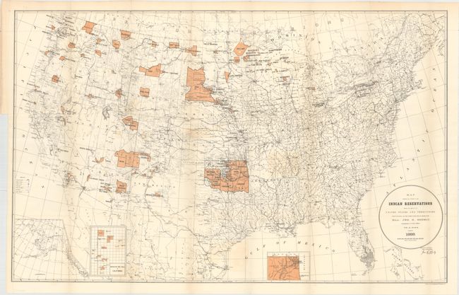
Auction 160, Lot 172
Subject: United States
U.S. Bureau of Indian Affairs
Map Showing the Location of the Indian Reservations Within the Limits of the United States and Territories..., 1888
Size: 33.3 x 20.9 inches (84.6 x 53.1 cm)
Estimate: $100 - $130
Sold for: $60
Closed on 11/16/2016

Auction 160, Lot 173
Subject: United States
A Good-Natured Map of the United States Setting Forth the Services of the Greyhound Lines and a Few Principal Connecting Bus Lines, 1937
Size: 29 x 19.1 inches (73.7 x 48.5 cm)
Estimate: $220 - $250
Pictographic Map of Greyhound Bus Lines
Sold for: $450
Closed on 11/16/2016

Auction 160, Lot 174
Subject: Colonial Eastern United States
Bellin, Jacques Nicolas
Karte von Luisiana, dem Laufe des Mississipi und den Benachbarten Laendern, 1744
Size: 21.7 x 15.4 inches (55.1 x 39.1 cm)
Estimate: $950 - $1,200
Scarce German Issue of Bellin's Louisiana Map
Sold for: $600
Closed on 11/16/2016

Auction 160, Lot 175
Subject: Eastern United States
Wilkinson, Robert
A Map of the United States of America, with Part of the Adjoining Provinces from the Latest Authorities, 1791
Size: 10.8 x 8.5 inches (27.4 x 21.6 cm)
Estimate: $200 - $230
Sold for: $160
Closed on 11/16/2016

Auction 160, Lot 176
Subject: Eastern United States
Russell, John C.
An Accurate Map of the United States of America, According to the Treaty of Peace of 1783, 1794
Size: 18.4 x 14.5 inches (46.7 x 36.8 cm)
Estimate: $450 - $550
Sold for: $300
Closed on 11/16/2016

Auction 160, Lot 177
Subject: Eastern United States
Cary, John
Part of North America, Comprehending the Course of the Ohio, New England, New York, New Jersey, Pennsylvania, Maryland, Virginia, Carolina & Georgia, 1795
Size: 11.6 x 8.3 inches (29.5 x 21.1 cm)
Estimate: $350 - $450
Sold for: $180
Closed on 11/16/2016
Auction 160, Lot 178
Subject: Eastern United States
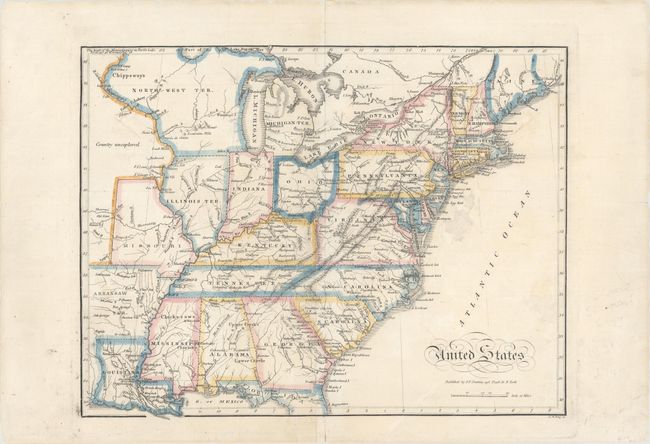
United States, 1821
Size: 12.5 x 9.7 inches (31.8 x 24.6 cm)
Estimate: $275 - $350
Sold for: $190
Closed on 11/16/2016

Auction 160, Lot 179
Subject: Eastern United States
Buchon, Jean Alexandre
Etats-Unis d'Amerique, 1825
Size: 20.9 x 16.8 inches (53.1 x 42.7 cm)
Estimate: $325 - $400
Sold for: $200
Closed on 11/16/2016

Auction 160, Lot 180
Subject: Eastern United States
Depot de la Marine
Carte de la Cote Orientale de l'Amerique Septentrionale Partie Comprise Entre New-York et la Riviere Saint Jean..., 1834
Size: 34.2 x 23.7 inches (86.9 x 60.2 cm)
Estimate: $800 - $950
Unsold
Closed on 11/16/2016
230 lots
Page 1 of 5