Filtered by Category:United States(Show All Categories)
Showing results for:Auction 139
Catalog Archive
172 lots
Page 1 of 4
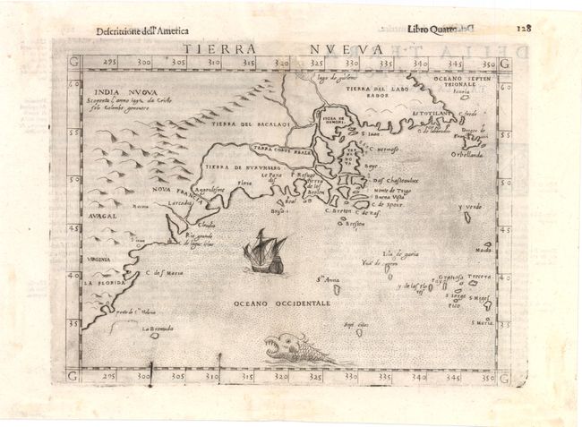
Auction 139, Lot 119
Subject: United States & Canada
Ruscelli, Girolamo
Tierra Nueva, 1598
Size: 9.7 x 7 inches (24.6 x 17.8 cm)
Estimate: $1,100 - $1,400
Sold for: $800
Closed on 2/15/2012
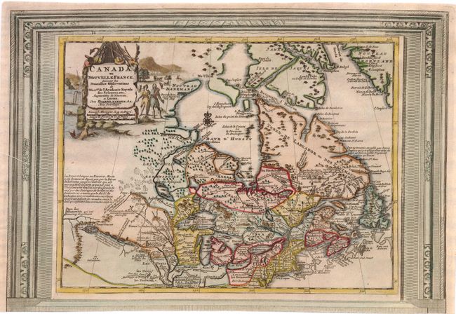
Auction 139, Lot 120
Subject: Colonial United States & Canada
Aa, Pieter van der
Canada ou Nouvelle France, Suivant les Nouvelles Observations de Messrs. de l'Academie Royale des Sciences…, 1730
Size: 15 x 10.5 inches (38.1 x 26.7 cm)
Estimate: $650 - $750
Unsold
Closed on 2/15/2012
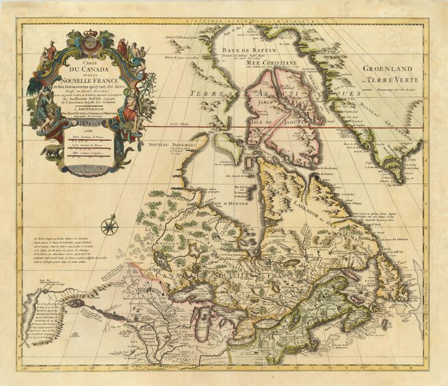
Auction 139, Lot 121
Subject: Colonial United States & Canada
Delisle/Covens & Mortier
Carte du Canada ou de la Nouvelle France et des Decouvertes qui y ont ete faites…, 1730
Size: 22.5 x 19.5 inches (57.2 x 49.5 cm)
Estimate: $1,300 - $1,600
One of the most influential maps of Canada, the Great Lakes and Upper Midwest
Sold for: $1,000
Closed on 2/15/2012
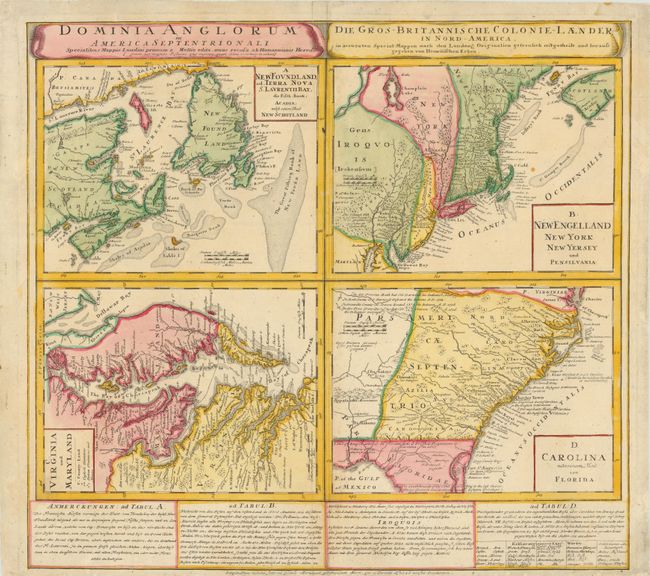
Auction 139, Lot 122
Subject: Colonial United States & Canada
Homann Heirs
Dominia Anglorum in America Septentrionali, 1740
Size: 21.5 x 19.8 inches (54.6 x 50.3 cm)
Estimate: $600 - $800
Sold for: $400
Closed on 2/15/2012
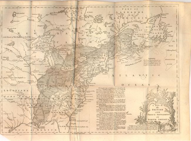
Auction 139, Lot 123
Subject: Colonial United States & Canada
Lodge, John
A Map of the British and French Settlements in North America, 1755
Size: 15.3 x 11 inches (38.9 x 27.9 cm)
Estimate: $400 - $500
Sold for: $425
Closed on 2/15/2012
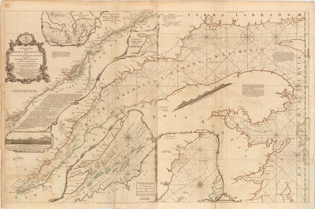
Auction 139, Lot 124
Subject: Colonial United States & Canada
Jefferys/Sayer & Bennett
An Exact Chart of the River St. Laurence, from Fort Frontenac to the Island of Anticosti Shewing the Soundings, Rocks, Shoals, &c. with Views of the Lands and All Necessary Instructions for Navigating that River to Quebec, 1775
Size: 37.5 x 23.5 inches (95.3 x 59.7 cm)
Estimate: $900 - $1,100
Sold for: $500
Closed on 2/15/2012
Auction 139, Lot 125
Subject: Colonial United States & Canada
Bonne/Lattre
[On 2 Sheets] Partie de l'Amerique Septentrionale, qui Comprend le Canada, la Louisiane, le Labrador, le Groenland, la Nouvelle Angleterre, la Floride &c., 1776
Size: 17 x 12.5 inches (43.2 x 31.8 cm)
Estimate: $600 - $750
Unsold
Closed on 2/15/2012
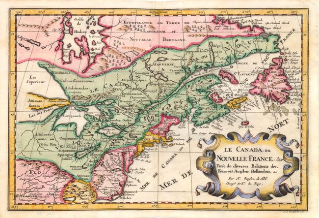
Auction 139, Lot 126
Subject: Colonial United States and Canada - Great Lakes
Sanson, Nicolas
Le Canada, ou Nouvelle France, &c Tiree de Diverses Relations des. Francois Anglois Hollandois, &c., 1715
Size: 11.8 x 8 inches (30 x 20.3 cm)
Estimate: $800 - $950
Small Version of a Keystone Map for Great Lakes Collections
Sold for: $475
Closed on 2/15/2012
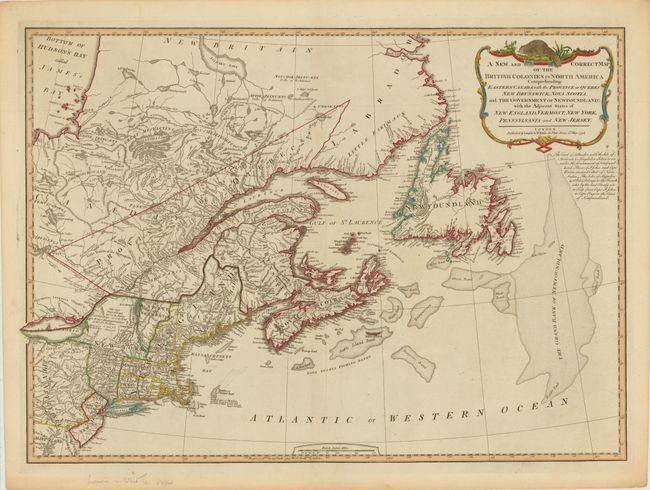
Auction 139, Lot 127
Subject: Canada & United States
Laurie & Whittle
A New and Correct Map of the British Colonies in North America Comprehending Eastern Canada with the Province of Quebec, New Brunswick, Nova Scotia, ...Newfoundland: with the Adjacent States of New England, Vermont, New York, Pennsylvania and New Jersey, 1794
Size: 26.5 x 18.8 inches (67.3 x 47.8 cm)
Estimate: $700 - $900
Sold for: $400
Closed on 2/15/2012
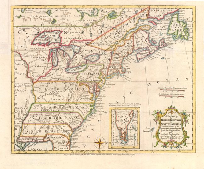
Auction 139, Lot 128
Subject: Eastern Colonial United States and Canada
Kitchin, Thomas
A New Map of the British Dominions in North America; with the Limits of the Governments Annexed thereto by the Late Treaty of Peace, and Settled by Proclamation, October 7th, 1763, 1763
Size: 12 x 9.5 inches (30.5 x 24.1 cm)
Estimate: $500 - $600
Sold for: $600
Closed on 2/15/2012
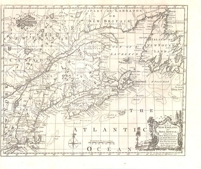
Auction 139, Lot 129
Subject: Colonial Eastern Canada & United States
Kitchin, Thomas
A Map of New England, and Nova Scotia; with Part of New York, Canada, and New Britain & the Adjacent Islands of New Found Land Cape Breton &c., 1758
Size: 13 x 10.8 inches (33 x 27.4 cm)
Estimate: $375 - $450
Unsold
Closed on 2/15/2012
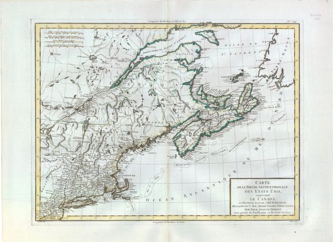
Auction 139, Lot 130
Subject: Eastern Canada & United States
Tardieu, Pierre Francois
Carte de la Partie Septentrionale des Etats Unis, comprenant le Canada, La Nouvelle Ecosse, New Hampshire, Massachuset's Bay, Rhode-Island, Connecticut, New-Yorck, Etat de Vermont avec partie de Pensilvanie et de New-Jersey, 1797
Size: 16.8 x 12.5 inches (42.7 x 31.8 cm)
Estimate: $275 - $350
Sold for: $150
Closed on 2/15/2012
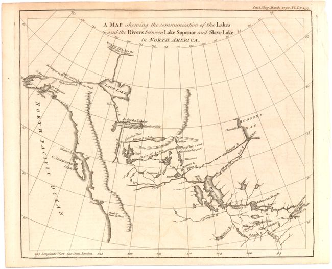
Auction 139, Lot 131
Subject: Western Canada and Alaska
Anon.
A Map Shewing the Communication of the Lakes and the Rivers Between Lake Superior and Slave Lake in North America, 1790
Size: 9.3 x 8 inches (23.6 x 20.3 cm)
Estimate: $300 - $400
Sold for: $180
Closed on 2/15/2012
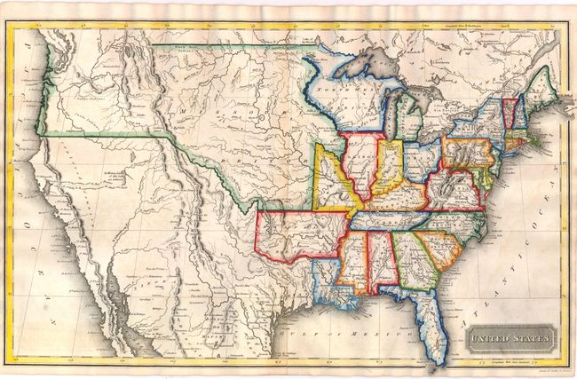
Auction 139, Lot 132
Subject: United States
Morse, Jedidiah & Sydney
United States, 1822
Size: 17 x 10.5 inches (43.2 x 26.7 cm)
Estimate: $275 - $350
Sold for: $1,000
Closed on 2/15/2012
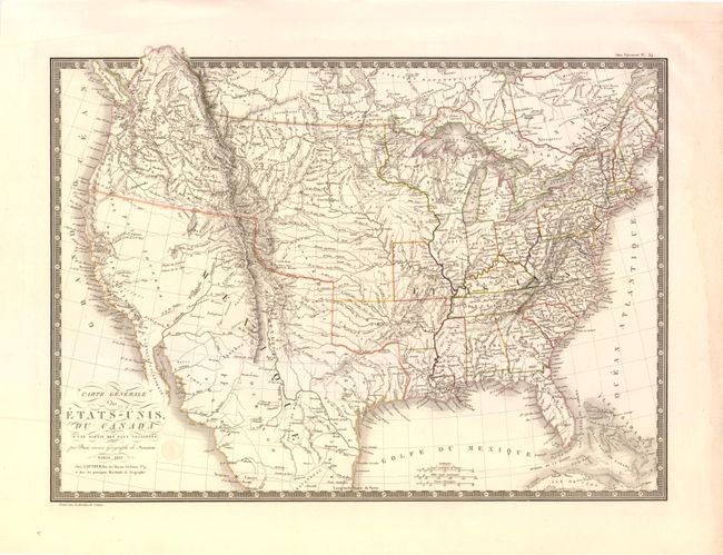
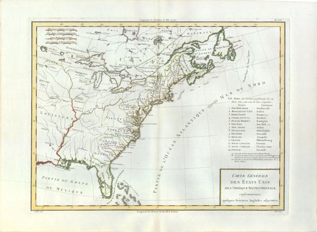
Auction 139, Lot 133
Subject: United States
Brue, Adrien Hubert
Carte Generale des Etats-Unis, du Canada et d'une Partie des Pays Adjacents, 1825
Size: 20 x 14.3 inches (50.8 x 36.3 cm)
Estimate: $350 - $450
Sold for: $250
Closed on 2/15/2012
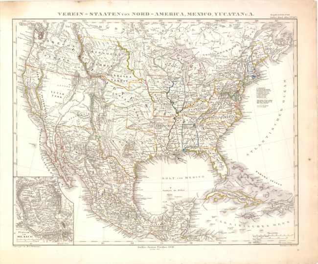
Auction 139, Lot 134
Subject: United States
[Lot of 3] Der Nordliche Theil der Vereinigten Staaten von Nord America… [and] Etats-Unis… [and] Verein-Staaten von Nord-America, Mexico, Yucatan U. A., 1832-51
Size: See Description
Estimate: $275 - $350
Sold for: $200
Closed on 2/15/2012
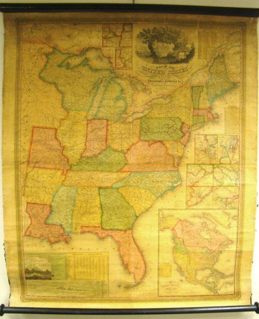
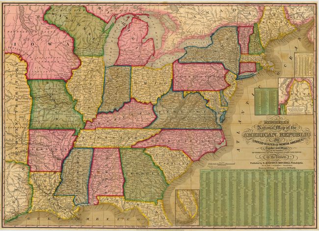
Auction 139, Lot 135
Subject: United States
Mitchell, Samuel Augustus
Map of the United States by J.H. Young, 1833
Size: 35 x 44 inches (88.9 x 111.8 cm)
Estimate: $1,000 - $1,500
Rare, Early Edition Mitchell Wall Map
Sold for: $1,200
Closed on 2/15/2012
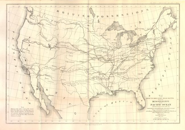
Auction 139, Lot 136
Subject: United States
U.S. War Department
Map of the Practicable Rail Road Routes from the Mississippi to the Pacific Ocean and their Connection with the Principal Seaports of the Atlantic Ocean…, 1859
Size: 14 x 9.5 inches (35.6 x 24.1 cm)
Estimate: $200 - $300
Sold for: $275
Closed on 2/15/2012
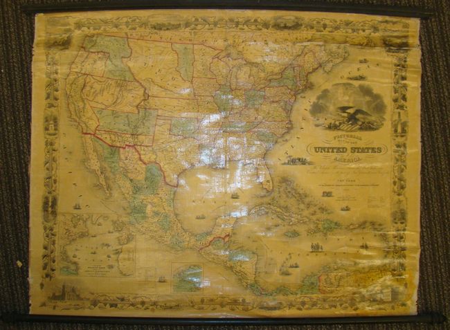
Auction 139, Lot 137
Subject: United States
Phelps & Watson
Pictorial Map of the United States of America, the British Provinces, Mexico, the West Indies and Central America…, 1860
Size: 41.5 x 34 inches (105.4 x 86.4 cm)
Estimate: $1,200 - $1,600
Sold for: $850
Closed on 2/15/2012
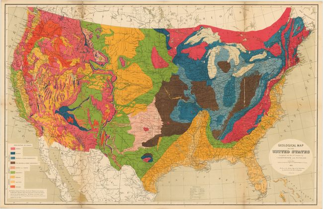
Auction 139, Lot 138
Subject: United States
Hitchcock, Charles Henry
Geological Map of the United States [with report] Ninth Census-Volume III. The Statistics of the Wealth and Industry of the United States…, 1874
Size: 9.5 x 12 inches (24.1 x 30.5 cm)
Estimate: $600 - $700
Unsold
Closed on 2/15/2012
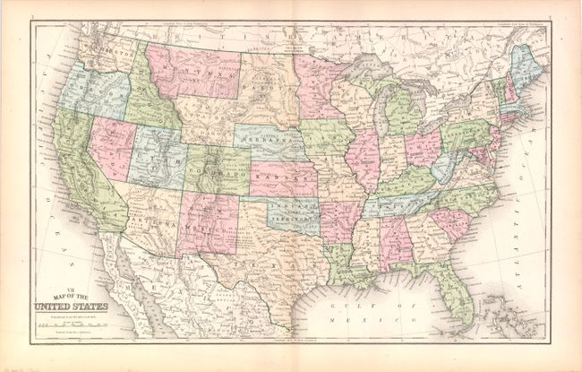
Auction 139, Lot 139
Subject: United States
Mitchell, Samuel Augustus
VII Map of the United States, 1889
Size: 17.3 x 10.8 inches (43.9 x 27.4 cm)
Estimate: $100 - $130
Unsold
Closed on 2/15/2012
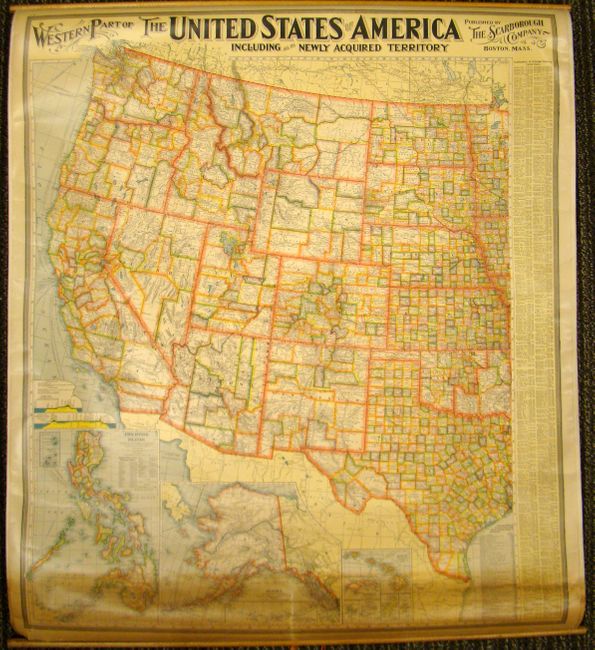
Auction 139, Lot 140
Subject: United States
Scarborough Company, The
[Double-sided wall map] Eastern Part of the United States of America Including All Its Newly Acquired Territories [and] Western Part…, 1900
Size: 34 x 39.5 inches (86.4 x 100.3 cm)
Estimate: $160 - $200
Sold for: $120
Closed on 2/15/2012
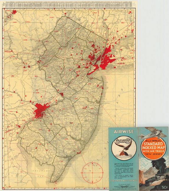
Auction 139, Lot 141
Subject: United States
Rand McNally & Co.
[Lot of 46] Rand McNally Standard Indexed Map with Air Trails, 1929-30
Size: 18.5 x 26 inches (47 x 66 cm)
Estimate: $1,600 - $2,000
Rare Rand McNally "Air Trails" Pocket Maps
Unsold
Closed on 2/15/2012
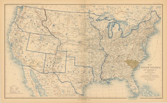
Auction 139, Lot 142
Subject: United States, Civil War
U.S. War Department
[Lot of 10] Map of the United States of America, Showing the Boundaries of the Union and Confederate Geographical Divisions and Departments Plates CLXII - CLXXI, 1891-1895
Size: 27.8 x 16.5 inches (70.6 x 41.9 cm)
Estimate: $1,300 - $1,600
Complete Set of Civil War Maps
Sold for: $800
Closed on 2/15/2012
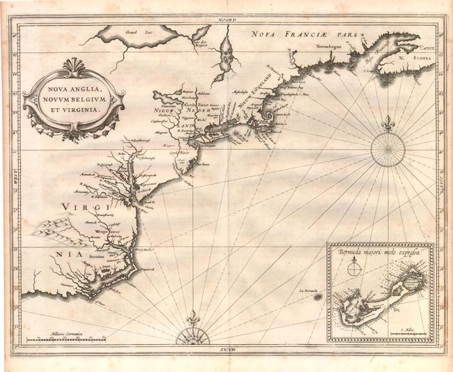
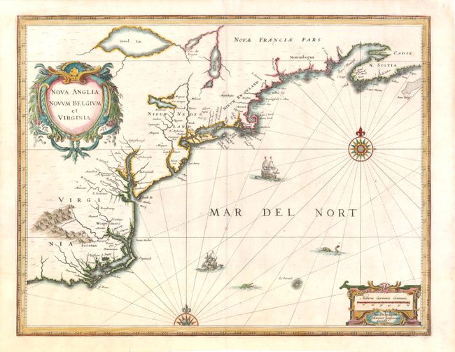
Auction 139, Lot 143
Subject: Colonial United States
Gerritsz/De Laet
Nova Anglia, Novum Belgium et Virginia, 1630
Size: 14 x 11 inches (35.6 x 27.9 cm)
Estimate: $5,000 - $7,000
A Map of Extreme Importance in the Cartographic Evolution of North America
Sold for: $3,750
Closed on 2/15/2012
Auction 139, Lot 144
Subject: Eastern United States
Tardieu, Pierre Francois
Carte Generale des Etats Unis de l'Amerique Septentrionale, renfermant aussi quelques Provinces Angloises adjacentes, 1797
Size: 17 x 12.8 inches (43.2 x 32.5 cm)
Estimate: $400 - $500
Sold for: $300
Closed on 2/15/2012
Auction 139, Lot 145
Subject: Eastern United States
Mitchell, Samuel Augustus
Mitchell's Travellers Guide Through the United States. A Map of the Roads, Distances, Steam Boat & Canal Routes &c., 1835
Size: 21.8 x 17.3 inches (55.4 x 43.9 cm)
Estimate: $1,000 - $1,200
Unsold
Closed on 2/15/2012
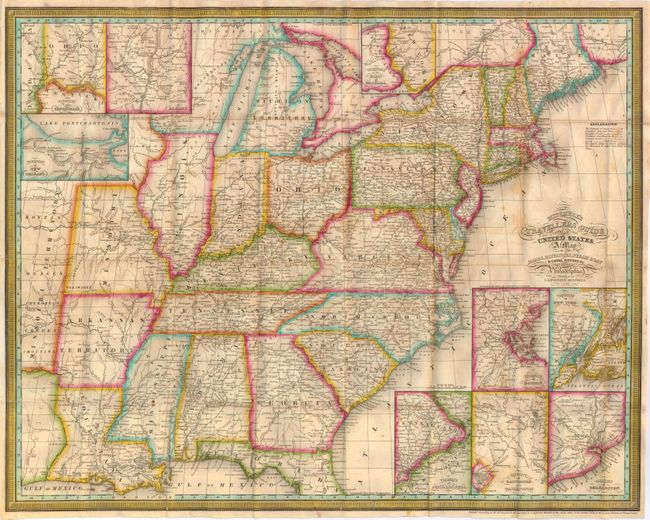
Auction 139, Lot 146
Subject: Eastern United States
Mitchell, Samuel Augustus
[On 2 Sheets] Mitchell's National Map of the American Republic or United States of North America. Together with Maps of the Vicinities of Thirty-Two of the Principal Cities & Towns in the Union …, 1843
Size: 34 x 24.5 inches (86.4 x 62.2 cm)
Estimate: $1,000 - $1,300
Sold for: $750
Closed on 2/15/2012
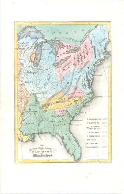
Auction 139, Lot 147
Subject: Eastern United States
Religious Society of Friends
Aboriginal America, East of the Mississippi, 1844
Size: 4.3 x 6.3 inches (10.9 x 16 cm)
Estimate: $100 - $130
Sold for: $75
Closed on 2/15/2012
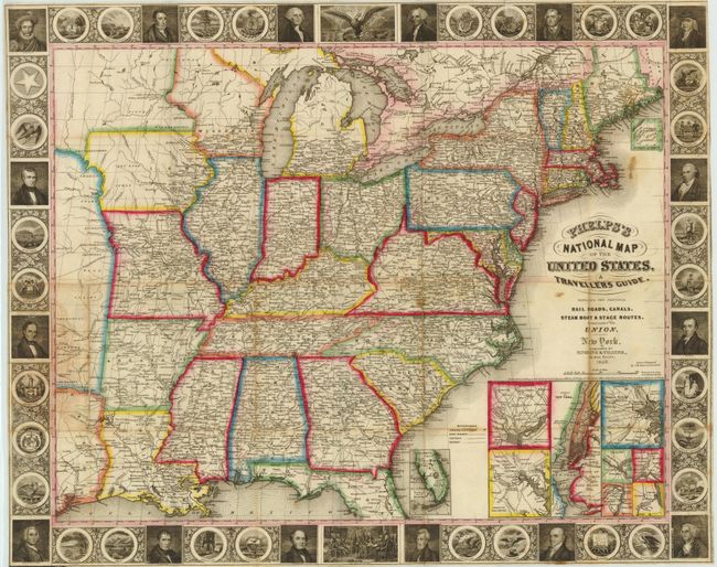
Auction 139, Lot 148
Subject: Eastern United States
Phelps & Ensign
Phelps's National Map of the United States, A Traveller's Guide, 1849
Size: 25 x 20 inches (63.5 x 50.8 cm)
Estimate: $700 - $1,000
Sold for: $500
Closed on 2/15/2012
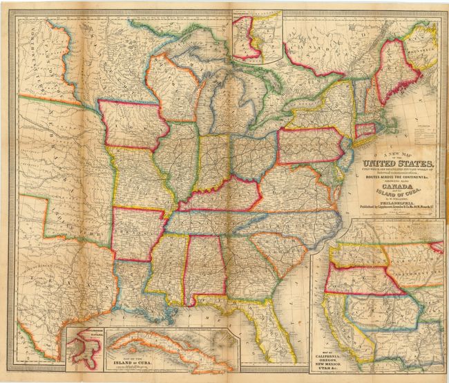
Auction 139, Lot 149
Subject: Eastern United States
Williams, Wellington
A New Map of the United States, Upon Which Are Delineated Its Vast Works of Internal Communication, Routes Across the Continent &c. Showing Also Canada and the Island Of Cuba., 1854
Size: 29.5 x 24.3 inches (74.9 x 61.7 cm)
Estimate: $900 - $1,100
Unsold
Closed on 2/15/2012
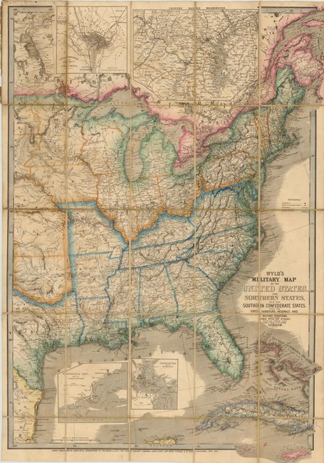
Auction 139, Lot 150
Subject: Eastern United States
Wyld, James
Wyld's Military Map of the United States, the Northern States, and the Southern Confederate States, with the Forts, Harbours, Arsenals, and Military Positions, 1861
Size: 23.3 x 35 inches (59.2 x 88.9 cm)
Estimate: $1,800 - $2,200
Important Civil War Map
Sold for: $1,300
Closed on 2/15/2012
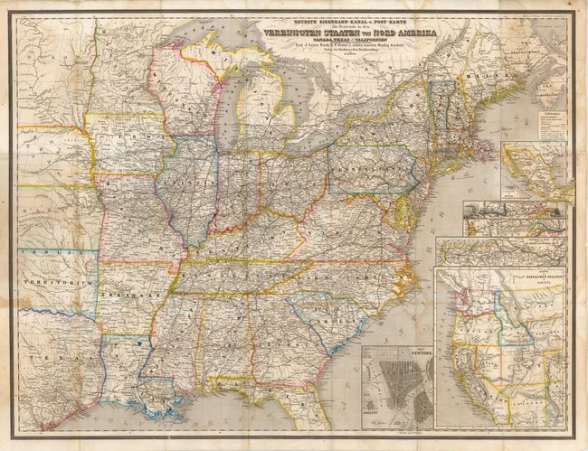
Auction 139, Lot 151
Subject: Eastern United States
Bromme, Traugott
Neueste Eisenbahn-Kanal-u. Post-Karte fur Reisende in den Vereinigten Staaten von Nord-Amerika Canada, Texas u. Californien…, 1863
Size: 29 x 21.5 inches (73.7 x 54.6 cm)
Estimate: $325 - $400
Unsold
Closed on 2/15/2012
Auction 139, Lot 152
Subject: Colonial New England and Mid-Atlantic
Jansson, Jan
Nova Anglia Novum Belgium et Virginia, 1636
Size: 20 x 15.3 inches (50.8 x 38.9 cm)
Estimate: $2,100 - $2,400
Jansson's Influential Map of the East Coast
Sold for: $2,000
Closed on 2/15/2012
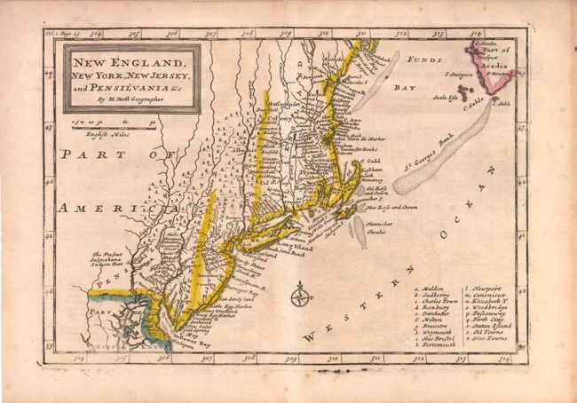
Auction 139, Lot 153
Subject: Colonial New England and Mid-Atlantic
Moll, Herman
New England, New York, New Jersey, and Pensilvania &c., 1708
Size: 10.3 x 7.3 inches (26.2 x 18.5 cm)
Estimate: $350 - $450
Sold for: $225
Closed on 2/15/2012
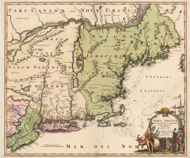
Auction 139, Lot 154
Subject: Colonial New England and Mid-Atlantic
Homann, Johann Baptist
Nova Anglia Septentrionali Americae Implantata Anglorumque Coloniis Florentissima, 1730
Size: 22.3 x 19 inches (56.6 x 48.3 cm)
Estimate: $1,000 - $1,400
Unsold
Closed on 2/15/2012
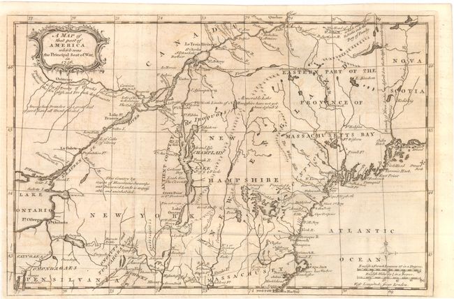
Auction 139, Lot 155
Subject: Colonial New England and Mid-Atlantic
Anon.
A Map of that Part of America which Was the Principal Seat of War, in 1756, 1757
Size: 13.3 x 8.8 inches (33.8 x 22.4 cm)
Estimate: $275 - $350
Sold for: $220
Closed on 2/15/2012
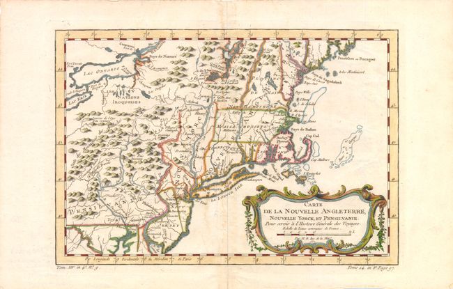
Auction 139, Lot 156
Subject: Colonial New England and Mid-Atlantic
Bellin, Jacques Nicolas
Carte de la Nouvelle Angleterre, Nouvelle Yorck, et Pensilvanie…, 1757
Size: 11.8 x 8 inches (30 x 20.3 cm)
Estimate: $275 - $350
Unsold
Closed on 2/15/2012
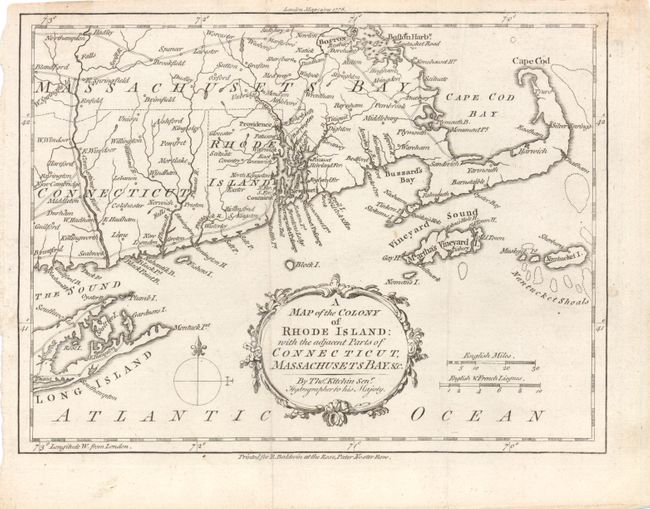
Auction 139, Lot 157
Subject: New England - United States
Kitchin, Thomas
A Map of the Colony of Rhode Island: with the Adjacent Parts of Connecticut, Massachusets Bay. &c., 1778
Size: 9.5 x 7 inches (24.1 x 17.8 cm)
Estimate: $300 - $375
Sold for: $220
Closed on 2/15/2012
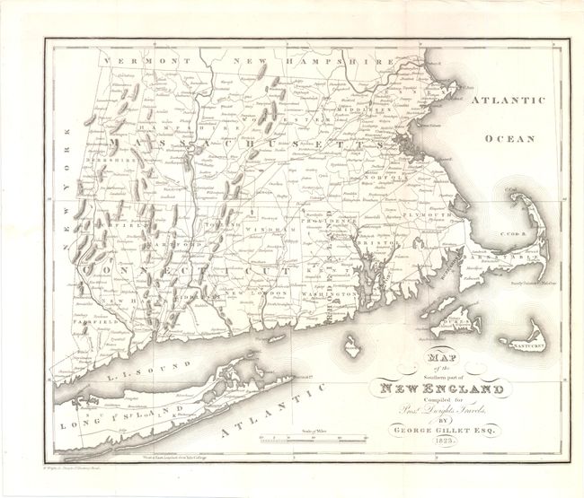
Auction 139, Lot 158
Subject: New England - United States
Gillet, George
Map of the Southern Part of New England Compiled for Prest Dwights Travels, 1823
Size: 13.5 x 11 inches (34.3 x 27.9 cm)
Estimate: $140 - $180
Sold for: $100
Closed on 2/15/2012
Auction 139, Lot 159
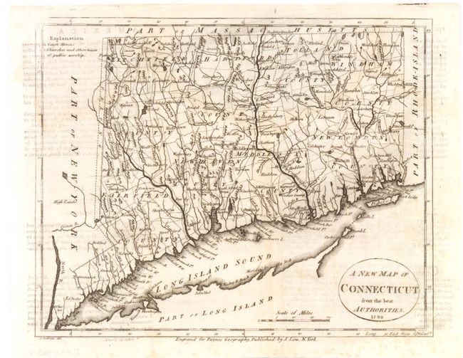
Subject: New England - Connecticut, Massachusetts & Rhode Island
Payne, John
[Lot of 3] A New Map of Connecticut from the Best Authorities [and] The State of Massachusetts from the Best Information [and] Rhode Island, 1799
Size: 9.3 x 7.5 inches (23.6 x 19.1 cm)
Estimate: $350 - $450
Sold for: $180
Closed on 2/15/2012
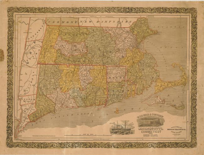
Auction 139, Lot 160
Subject: New England - United States
Thayer & Co.
Rail-Road & Township Map of Massachusetts, Connecticut and Rhode Island, 1853
Size: 25 x 18 inches (63.5 x 45.7 cm)
Estimate: $250 - $325
Unsold
Closed on 2/15/2012
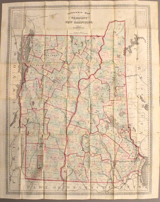
Auction 139, Lot 161
Subject: Vermont, New Hampshire
Dutton, E. P.
Township Map of Vermont and New Hampshire, 1868
Size: 22.5 x 29.5 inches (57.2 x 74.9 cm)
Estimate: $150 - $200
Unsold
Closed on 2/15/2012
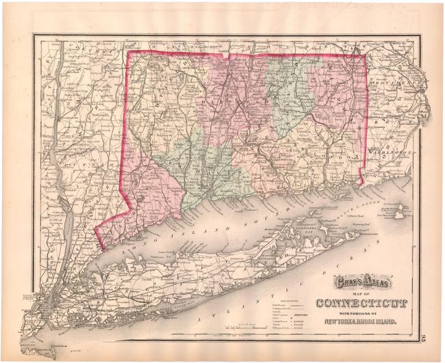
Auction 139, Lot 162
Subject: Connecticut
[Lot of 5] Gray's Atlas Map of Connecticut… [and] Map of the City of Bridgeport, Conn, 1896 [and] City of Bridgeport Connecticut 1890 [and] New Map of Hartford, Connecticut [and] Map of Bridgeport Conn., 1890-1910
Size: See Description
Estimate: $120 - $200
Unsold
Closed on 2/15/2012
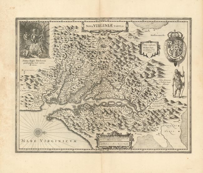
Auction 139, Lot 163
Subject: Colonial Mid-Atlantic
Hondius, Henricus
Nova Virginiae Tabula, 1630
Size: 19.5 x 15 inches (49.5 x 38.1 cm)
Estimate: $2,300 - $3,000
Unsold
Closed on 2/15/2012
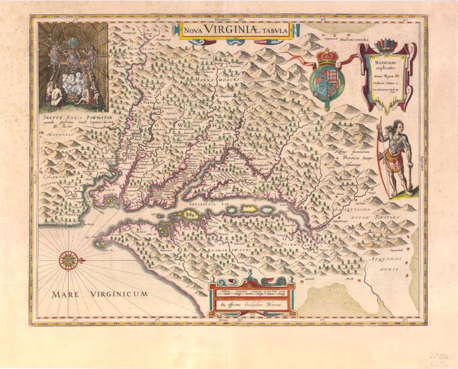
Auction 139, Lot 164
Subject: Colonial Mid-Atlantic
Hondius/Blaeu
Nova Virginiae Tabula, 1640
Size: 19 x 14.8 inches (48.3 x 37.6 cm)
Estimate: $3,000 - $4,000
Sold for: $1,900
Closed on 2/15/2012

Auction 139, Lot 165
Subject: Mid-Atlantic United States
Anon.
Carte de la Pensilvanie, 1756
Size: 7.5 x 10 inches (19.1 x 25.4 cm)
Estimate: $275 - $350
Sold for: $200
Closed on 2/15/2012
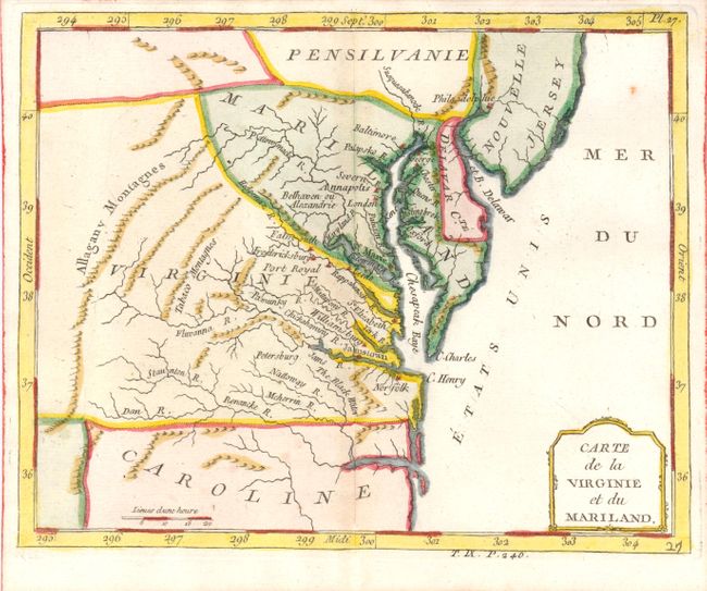
Auction 139, Lot 166
Subject: Mid-Atlantic United States
Laporte, Joseph de
Carte de la Virginie et du Mariland, 1783
Size: 8.8 x 7 inches (22.4 x 17.8 cm)
Estimate: $275 - $350
Sold for: $180
Closed on 2/15/2012
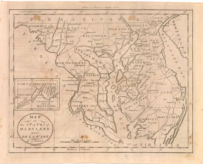
Auction 139, Lot 167
Subject: Mid-Atlantic United States
Denison, James
Map of the States of Maryland and Delaware, 1796
Size: 9.5 x 7.5 inches (24.1 x 19.1 cm)
Estimate: $190 - $220
Sold for: $140
Closed on 2/15/2012
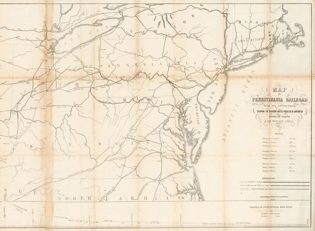
Auction 139, Lot 168
Subject: Mid-Atlantic United States
Railroad Companies, (Various)
Map of the Pennsylvania Railroad with its Connections, Showing the Different Routes, Projected or Constructed between the Seaboard & the Western States, 1850
Size: 55 x 23.3 inches (139.7 x 59.2 cm)
Estimate: $500 - $600
Very early map of the Pennsylvania Railroad
Sold for: $300
Closed on 2/15/2012
172 lots
Page 1 of 4