Filtered by Category:United States(Show All Categories)
Showing results for:Auction 100
Catalog Archive
121 lots
Page 1 of 3
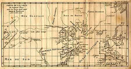
Auction 100, Lot 99
Subject: North America - Arctic
Robert de Vaugondy, Didier
Partie de la Carte du Capitaine Cluny Auteur d'un ouvrage anglois intitule American Traveller, 1769
Size: 16.3 x 8.3 inches (41.4 x 21.1 cm)
Estimate: $160 - $200
Unsold
Closed on 9/12/2002
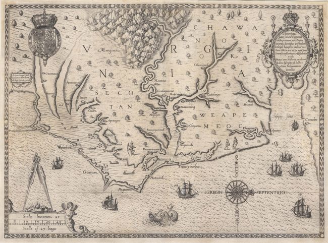
Auction 100, Lot 102
Subject: Colonial Southeast
White/De Bry
Americae pars, Nunc Virginia dicta, primum ab Anglis inuenta sumtibus Dn. Walteri Raleigh, Equestris ordinis Viri, 1590
Size: 16.2 x 16.7 inches (41.1 x 42.4 cm)
Estimate: $15,000 - $17,000
Sold for: $12,000
Closed on 9/12/2002
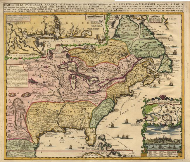
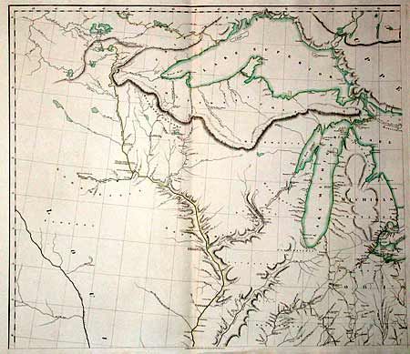
Auction 100, Lot 103
Subject: Colonial North America
Chatelain, Henry Abraham
Carte de la Nouvelle France, ou se voit le cours des Grandes Rivieres de S. Laurens & de Mississipi Aujour d'hui S. Louis, Aux Environs des-quelles se trouvent les Etats, Pais, Nations, Peuples &c., 1719
Size: 19 x 16.5 inches (48.3 x 41.9 cm)
Estimate: $2,500 - $2,750
Sold for: $1,900
Closed on 9/12/2002
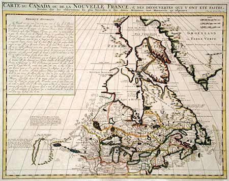
Auction 100, Lot 104
Subject: Colonial North America
Chatelain, Henry Abraham
Carte du Canada ou de la Nouvelle France, & Des Decouvertes Qui Y Ont Ete Faites, Dressee sur les observations les plus Nouvelles, & sur divers Memoires tant Manuscrits qu' imprimez, 1719
Size: 20.3 x 15.8 inches (51.6 x 40.1 cm)
Estimate: $750 - $850
Sold for: $650
Closed on 9/12/2002
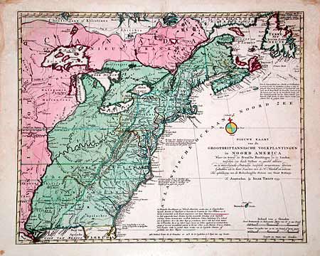
Auction 100, Lot 105
Subject: Colonial North America
Tirion, Isaac
Nieuwe Kaart van de Grootbrittannische Volkplantingen in Noord America, 1755
Size: 17.8 x 14.3 inches (45.2 x 36.3 cm)
Estimate: $800 - $900
Sold for: $600
Closed on 9/12/2002
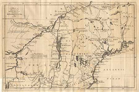
Auction 100, Lot 106
Subject: Colonial New England
Anon.
A Map of that part of America which was the Principal Seat of War in 1756, 1757
Size: 13 x 8.5 inches (33 x 21.6 cm)
Estimate: $300 - $400
Sold for: $275
Closed on 9/12/2002
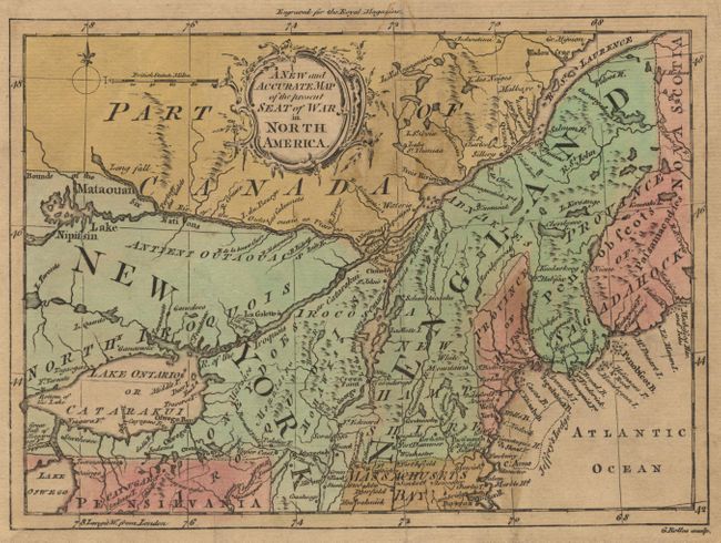
Auction 100, Lot 107
Subject: Colonial New England
Rollos, George
A New and Accurate Map of the present Seat of War in North America from a Late Survey, 1759
Size: 8.8 x 6.4 inches (22.4 x 16.3 cm)
Estimate: $230 - $275
Sold for: $275
Closed on 9/12/2002
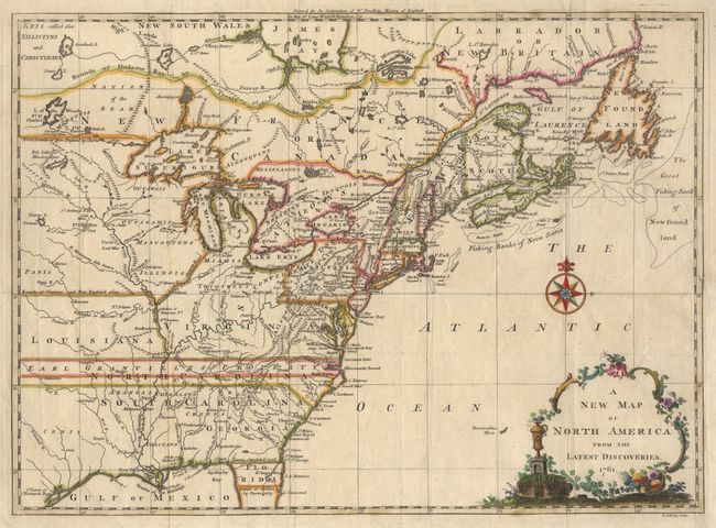
Auction 100, Lot 108
Subject: Colonial United States and Canada
Spilsbury, J.
A New Map of North America from the Latest Discoveries, 1761
Size: 14.8 x 10.8 inches (37.6 x 27.4 cm)
Estimate: $325 - $375
Sold for: $450
Closed on 9/12/2002
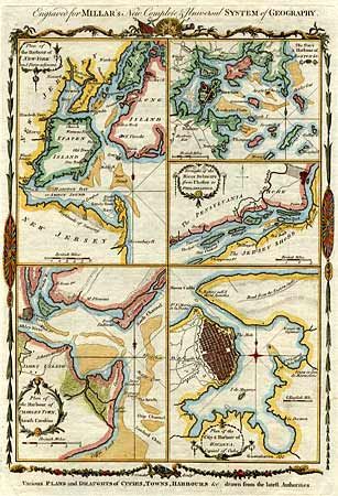
Auction 100, Lot 109
Subject: Colonial North America
Conder, Thomas
Various Plans and Draughts of Cities, Towns, Harbours &c. Drawn from the latest Authorities, 1782
Size: 8.3 x 12 inches (21.1 x 30.5 cm)
Estimate: $200 - $250
Sold for: $375
Closed on 9/12/2002
Auction 100, Lot 110
Subject: Florida
Bellin, Jacques Nicolas
Plan de la Baye de Pensacola dans la Floride, 1757
Size: 6.7 x 8.5 inches (17 x 21.6 cm)
Estimate: $600 - $700
Sold for: $1,000
Closed on 9/12/2002
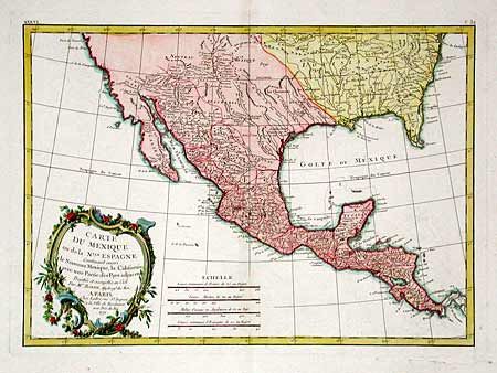
Auction 100, Lot 113
Subject: Southern United States, Mexico & Central America
Bonne, Rigobert
Carte du Mexique ou de la Nlle. Espagne…, 1771
Size: 16 x 11.5 inches (40.6 x 29.2 cm)
Estimate: $400 - $450
Sold for: $300
Closed on 9/12/2002
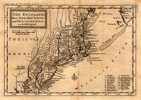
Auction 100, Lot 114
Subject: Colonial New England
Moll, Herman
Neu Engeland, Neu York, Neu Iersey, und Pensilvanien &c, 1744
Size: 10.2 x 7 inches (25.9 x 17.8 cm)
Estimate: $325 - $375
Sold for: $300
Closed on 9/12/2002
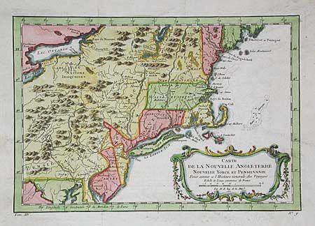
Auction 100, Lot 115
Subject: Colonial New England
Bellin, Jacques Nicolas
Carte de la Nouvelle Angleterre, Nouvelle Yorck et Pensilvanie, 1767
Size: 11.8 x 8.1 inches (30 x 20.6 cm)
Estimate: $325 - $375
Sold for: $450
Closed on 9/12/2002
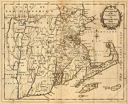
Auction 100, Lot 116
Subject: Colonial New England
Anon.
A New and accurate Map of the Colony of Massachusets Bay, in North America from a Late Survey, 1780
Size: 12.8 x 10.3 inches (32.5 x 26.2 cm)
Estimate: $350 - $400
Sold for: $250
Closed on 9/12/2002
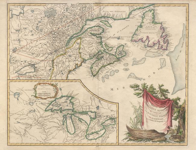
Auction 100, Lot 117
Subject: Colonial Canada - Great Lakes
Robert de Vaugondy, Didier
Partie de l'Amerique Septent? qui comprend la Nouvelle France ou le Canada, 1763
Size: 23.5 x 18.5 inches (59.7 x 47 cm)
Estimate: $800 - $900
Unsold
Closed on 9/12/2002
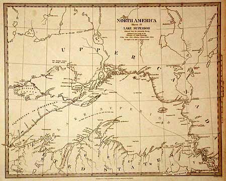
Auction 100, Lot 127
Subject: Canada & United States
SDUK Society for the Diffusion of Useful Knowledge
North America Sheet IV Lake Superior, 1832
Size: 15 x 12 inches (38.1 x 30.5 cm)
Estimate: $70 - $90
Sold for: $80
Closed on 9/12/2002
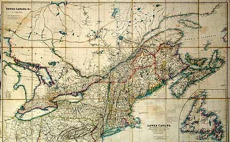
Auction 100, Lot 128
Subject: Canada & United States
Arrowsmith, John
Lower Canada, New Brunswick, Nova Scotia, Prince Edwards Id. Newfoundland, and a large portion of the United States, 1837
Size: 37.8 x 23.8 inches (96 x 60.5 cm)
Estimate: $350 - $400
Sold for: $300
Closed on 9/12/2002
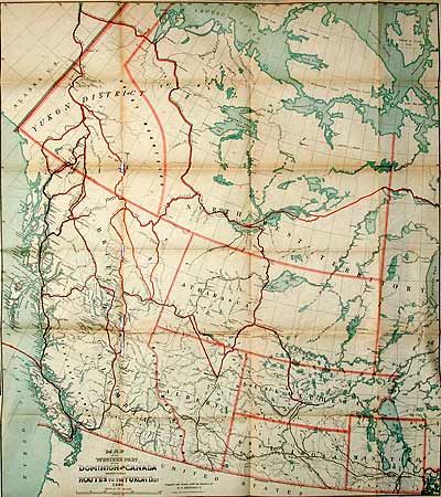
Auction 100, Lot 129
Subject: Canada and Alaska
Matthews-Northrup Co
Map of the Western Part of the Dominion of Canada Shewing Various Routes to the Yukon Dist., 1898
Size: 31 x 34 inches (78.7 x 86.4 cm)
Estimate: $75 - $100
Sold for: $70
Closed on 9/12/2002
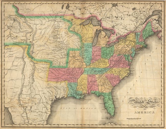
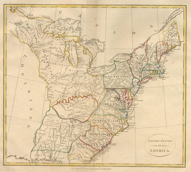
Auction 100, Lot 130
Subject: United States
Arrowsmith, Aaron, Sr.
A Map of the United States of North America Drawn from a number of Critical Researches, 1815
Size: 56 x 48 inches (142.2 x 121.9 cm)
Estimate: $4,000 - $5,000
Sold for: $6,000
Closed on 9/12/2002
Auction 100, Lot 131
Subject: United States
Melish, John
United States of America…, 1821
Size: 21.5 x 17 inches (54.6 x 43.2 cm)
Estimate: $1,000 - $1,200
Sold for: $800
Closed on 9/12/2002
Auction 100, Lot 132
Subject: United States
Longman Co.
United States of America, 1808
Size: 15.5 x 13.5 inches (39.4 x 34.3 cm)
Estimate: $200 - $250
Sold for: $325
Closed on 9/12/2002
Auction 100, Lot 133
Subject: United States
Phelps & Ensign
Map of the United States with the recent Counties, Cities, Villages and Internal Improvements in the Western States, by J.L. Woodbridge..., 1847
Size: 58 x 45 inches (147.3 x 114.3 cm)
Estimate: $1,200 - $1,600
Sold for: $1,000
Closed on 9/12/2002
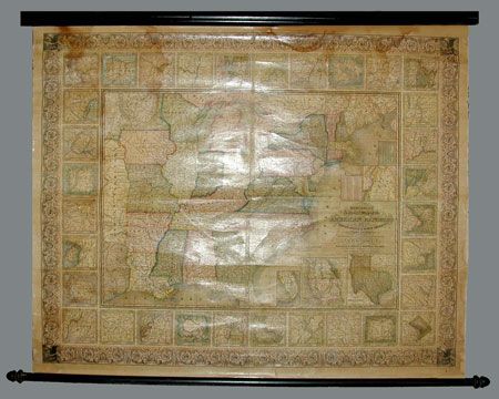
Auction 100, Lot 134
Subject: United States
Mitchell, Samuel Augustus
Mitchell's National Map of the American Republic or United States of North America, Together with Maps of the Vicinities of Thirty-Two of the Principal Cities and Towns in the Union, 1850
Size: 47.5 x 38 inches (120.7 x 96.5 cm)
Estimate: $1,200 - $1,600
Sold for: $1,000
Closed on 9/12/2002
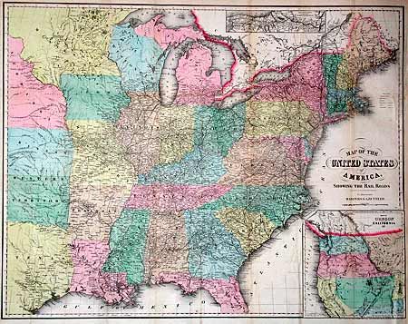
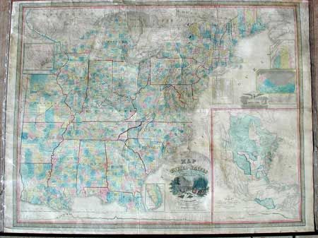
Auction 100, Lot 135
Subject: United States
Smith, J. Calvin
Map of the United States of America, Showing the Rail Roads To Illustrate Harpers Gazetteer, 1855
Size: 27 x 21 inches (68.6 x 53.3 cm)
Estimate: $300 - $400
Sold for: $300
Closed on 9/12/2002
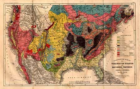
Auction 100, Lot 136
Subject: United States
Perthes, Justus
Geologische Karte der Vereinigten Staaten und Britischen Provinzen von Nord_Amerika, 1855
Size: 15.4 x 9.5 inches (39.1 x 24.1 cm)
Estimate: $150 - $200
Sold for: $180
Closed on 9/12/2002
Auction 100, Lot 137
Subject: United States.
Black, Adam & Charles
General Map of the United States, 1862
Size: 21.5 x 16.3 inches (54.6 x 41.4 cm)
Estimate: $60 - $80
Sold for: $160
Closed on 9/12/2002
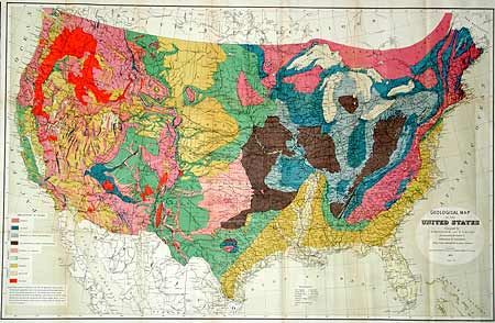
Auction 100, Lot 138
Subject: United States
Hitchcock, Charles Henry
Geological Map of the United States, 1873
Size: 33.2 x 21.5 inches (84.3 x 54.6 cm)
Estimate: $200 - $250
Sold for: $250
Closed on 9/12/2002
Auction 100, Lot 139
Subject: United States
U.S.D.A.
[Lot of 6 Thematic Maps], 1890
Size: See Description
Estimate: $60 - $80
Sold for: $0
Closed on 9/12/2002
Auction 100, Lot 140
Subject: Eastern United States
Bonne, Rigobert
Carte de la Partie Nord, des Etats Unis, de l'Amerique Septentrionale, 1780
Size: 12.6 x 8.5 inches (32 x 21.6 cm)
Estimate: $170 - $200
Sold for: $100
Closed on 9/12/2002
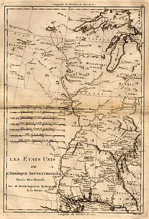
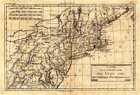
Auction 100, Lot 141
Subject: United States - Eastern
Bonne, Rigobert
Les Etats Unis de l'Amerique Septentrionale, Partie Occidentale [together with] … Partie Orientale, 1787-88
Size: 9.3 x 13.5 inches (23.6 x 34.3 cm)
Estimate: $450 - $550
Sold for: $325
Closed on 9/12/2002
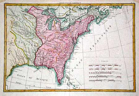
Auction 100, Lot 142
Subject: United States - Eastern
Bonne, Rigobert
Etats Unis de l'Amerique, 1788
Size: 17.2 x 11.5 inches (43.7 x 29.2 cm)
Estimate: $400 - $450
Sold for: $300
Closed on 9/12/2002
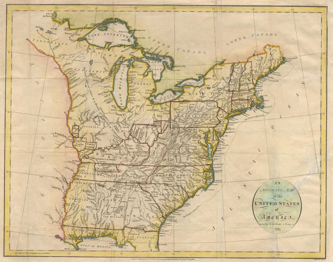
Auction 100, Lot 143
Subject: United States - Eastern
Russell, John C.
An Accurate Map of the United States of America according to the Treaty of Peace of 1783, 1794
Size: 18 x 14.2 inches (45.7 x 36.1 cm)
Estimate: $400 - $450
Sold for: $550
Closed on 9/12/2002
Auction 100, Lot 144
Subject: United States - Eastern
Tardieu
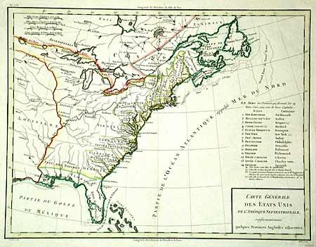
Carte Generale des Etats Unis de l'Amerique Septentrionale, renfermant aussi quelques Provinces Angloises adjacentes, 1797
Size: 16.8 x 12.8 inches (42.7 x 32.5 cm)
Estimate: $375 - $425
Sold for: $200
Closed on 9/12/2002
Auction 100, Lot 145
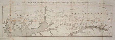
Subject: United States - Eastern
U.S. Corps of Engineers
Map of a Reconnaissance Between Baltimore and Philadelphia exhibiting the several routes of the Mail Road contemplated by the resolution of Congress approved on the 4th of May 1826, 1826
Size: 31 x 10 inches (78.7 x 25.4 cm)
Estimate: $300 - $350
Sold for: $250
Closed on 9/12/2002
Auction 100, Lot 146
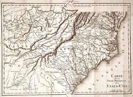
Subject: United States - Southeastern
Crevecoeur, Michel Guillaume De
Carte de la Partie Meridionale des Etats-Unis, 1801
Size: 19.8 x 14.1 inches (50.3 x 35.8 cm)
Estimate: $400 - $450
Unsold
Closed on 9/12/2002
Auction 100, Lot 147
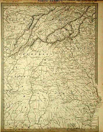
Subject: United States - Southern
SDUK Society for the Diffusion of Useful Knowledge
North America Sheet XII Georgia with parts of North & South Carolina, Tennessee, Alabama & Florida, 1833
Size: 12 x 15.7 inches (30.5 x 39.9 cm)
Estimate: $70 - $90
Sold for: $190
Closed on 9/12/2002
Auction 100, Lot 148
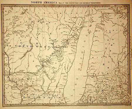
Subject: United States - North Central
SDUK Society for the Diffusion of Useful Knowledge
North America Sheet V The North West and Michigan Territories, 1833
Size: 15 x 11.8 inches (38.1 x 30 cm)
Estimate: $100 - $140
Sold for: $75
Closed on 9/12/2002
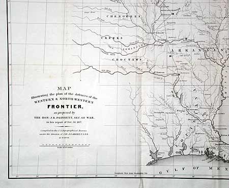
Auction 100, Lot 149
Subject: United States - Central Midwest
Poinsett, J. R.
Map Illustrating the plan of the defences of the Western & North-Western Frontier, as proposed by the Hon: J.R. Poinsett, Sec. of War, in his report of Dec. 30, 1837, 1837
Size: 15.5 x 21.5 inches (39.4 x 54.6 cm)
Estimate: $250 - $350
Sold for: $250
Closed on 9/12/2002
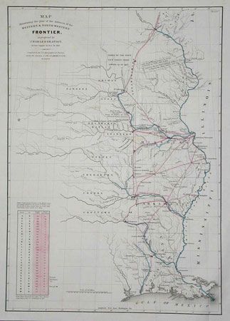
Auction 100, Lot 150
Subject: United States - Central Midwest
Gratiot, Charles
Map Illustrating the Plan of the Defences of the Western & North-Western Frontier, as proposed by Charles Gratiot, in his report of Oct. 31, 1837, 1838
Size: 15.2 x 21.5 inches (38.6 x 54.6 cm)
Estimate: $250 - $350
Sold for: $275
Closed on 9/12/2002
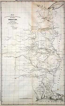
Auction 100, Lot 151
Subject: United States - Central Midwest
Burr, David H.
Map Illustrating the plan of the defences of the Western Frontier, as proposed by Maj. Gen. Gaines, in his plan dated Feby. 28th 1838, 1838
Size: 14.5 x 23.5 inches (36.8 x 59.7 cm)
Estimate: $300 - $350
Sold for: $325
Closed on 9/12/2002
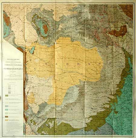
Auction 100, Lot 152
Subject: United States - Midwest
U.S. Geographical Survey
Preliminary Map Showing Present State of Knowledge relating to Underground Waters in the Central Great Plains [together with] Preliminary Geologic Map of the Central Great Plains, 1904
Size: 30 x 30 inches (76.2 x 76.2 cm)
Estimate: $120 - $150
Sold for: $120
Closed on 9/12/2002
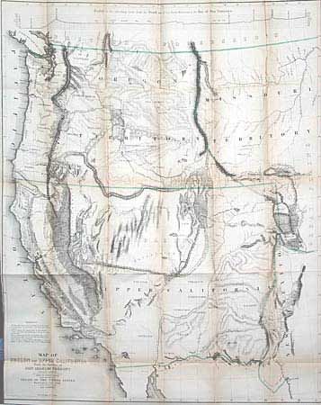
Auction 100, Lot 153
Subject: United States - Western
Fremont/Preuss
Map of Oregon and Upper California from the Surveys of John Charles Fremont and other Authorities, 1848
Size: 26.5 x 33.3 inches (67.3 x 84.6 cm)
Estimate: $1,400 - $1,800
Sold for: $1,900
Closed on 9/12/2002
Auction 100, Lot 154
Subject: United States - Western
Lange, Henry
Oregon, Californien, Utah, Neu Mexico, Etc, 1854
Size: 10.6 x 8.6 inches (26.9 x 21.8 cm)
Estimate: $200 - $250
Sold for: $350
Closed on 9/12/2002
Auction 100, Lot 155
Subject: Northwestern United States
U.S. War Dept.
Milk R. to the Crossing of the Columbia R…, 1855
Size: 61 x 23.5 inches (154.9 x 59.7 cm)
Estimate: $200 - $250
Sold for: $100
Closed on 9/12/2002
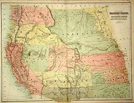
Auction 100, Lot 156
Subject: United States - Western
Black, Adam & Charles
United States Western States, including California, Oregon, Utah, Washington, New Mexico, Nebraska, Kansas, Indian Territory &c., 1862
Size: 22 x 16.5 inches (55.9 x 41.9 cm)
Estimate: $150 - $200
Sold for: $275
Closed on 9/12/2002
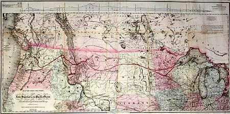
Auction 100, Lot 157
Subject: United States - Western
Colton, G.W. & C.B.
Map of the Country from Lake Superior to the Pacific Ocean. From the latest Explorations and Surveys to accompany the Report of Edwin F. Johnson Chf. Engr. Northern Pacific R.R., 1867
Size: 45 x 21.8 inches (114.3 x 55.4 cm)
Estimate: $450 - $550
Sold for: $600
Closed on 9/12/2002
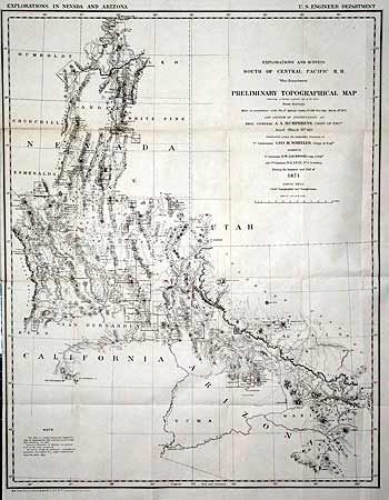
Auction 100, Lot 158
Subject: United States - Western
Wheeler, George (Lt)
Explorations and Surveys South of Central Pacific R. R. War Department Preliminary Topographical Map Embracing in skeleton a portion only of the Notes from Surveys…, 1871
Size: 22 x 28 inches (55.9 x 71.1 cm)
Estimate: $150 - $250
Sold for: $150
Closed on 9/12/2002
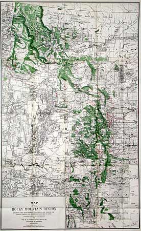
Auction 100, Lot 159
Subject: United States - Western
U.S.D.A.
Map of the Rocky Mountain Region Showing the Approximate Location and Extent of Forest Areas and Irrigation Ditches in 1885, 1885
Size: 19 x 31 inches (48.3 x 78.7 cm)
Estimate: $75 - $100
Sold for: $80
Closed on 9/12/2002
Auction 100, Lot 160
Subject: United States - Southwest
U.S. Government
[Lot of 7 Maps - Mexican Boundary Survey], 1851
Size: See Description
Estimate: $300 - $400
Sold for: $650
Closed on 9/12/2002
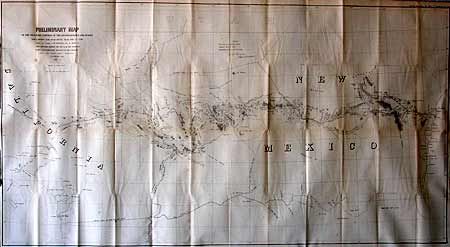
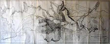
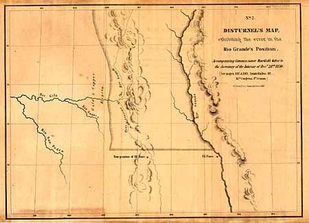
Auction 100, Lot 161
Subject: United States - Southwest
Whipple, Amiel Weekes
Preliminary Map of the Western Portion of the Reconnaissance and Survey for a Pacific Railroad Route Near the 35th Parallel Made by Capt. A.W. Whipple. T.E. in 1853-4…, 1858
Size: 49 x 26 inches (124.5 x 66 cm)
Estimate: $200 - $250
Sold for: $300
Closed on 9/12/2002
121 lots
Page 1 of 3