Filtered by Category:Pacific Ocean, New Zealand, Australia(Show All Categories)
Showing results for:Auction 157
Catalog Archive
21 lots

Auction 157, Lot 706
Subject: Pacific Ocean
Ortelius, Abraham
Maris Pacifici, (quod Vulgo Mar del Zur) cum Regionibus Circumiacentibus, Insulisque in Eodem Passim Sparsis, Novissima Descriptio, 1589
Size: 19.5 x 13.6 inches (49.5 x 34.5 cm)
Estimate: $8,000 - $9,000
The First Printed Map Devoted to the Pacific
Sold for: $6,000
Closed on 5/4/2016

Auction 157, Lot 707
Subject: Pacific Ocean
Jansson, Jan
Mar del Zur Hispanis Mare Pacificum, 1650
Size: 21.4 x 17.3 inches (54.4 x 43.9 cm)
Estimate: $1,900 - $2,200
Scarce First State
Unsold
Closed on 5/4/2016
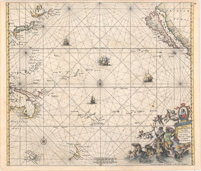
Auction 157, Lot 708
Subject: Pacific Ocean, California
Wit, Frederick de
Magnum Mare del Zur cum Insula California / De Groote Zuyd-Zee en 't Eylandt California, 1680
Size: 22.3 x 19.3 inches (56.6 x 49 cm)
Estimate: $2,750 - $3,500
One of the Finest Charts Showing California as an Island
Sold for: $2,000
Closed on 5/4/2016
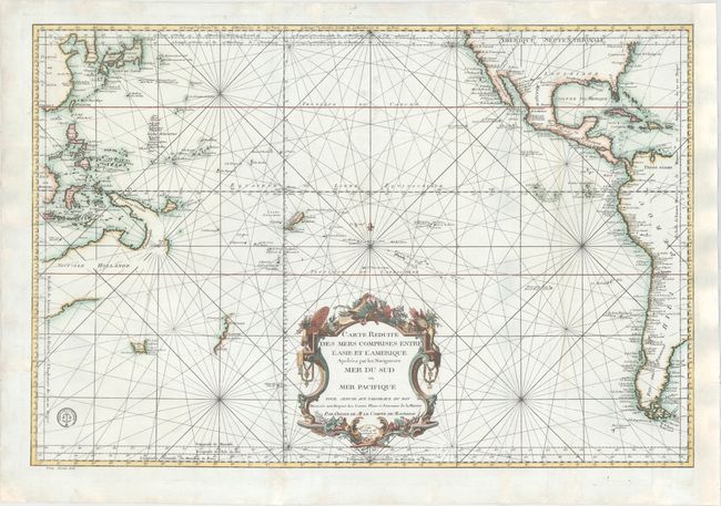
Auction 157, Lot 709
Subject: Pacific Ocean
Bellin, Jacques Nicolas
Carte Reduite des Mers Comprises Entre l'Asie et l'Amerique Apelees par les Navigateurs Mer du Sud ou Mer Pacifique..., 1776
Size: 32.6 x 21.8 inches (82.8 x 55.4 cm)
Estimate: $1,100 - $1,400
Sold for: $800
Closed on 5/4/2016
Auction 157, Lot 710
Subject: Pacific Ocean
[Lot of 2] Oceanie [and] Islands in the Pacific Ocean, 1840-60
Size: See Description
Estimate: $120 - $150
NO RESERVE
Unsold
Closed on 5/4/2016

Auction 157, Lot 711
Subject: North Pacific, Northern Asia & Northwestern North America
Ortelius, Abraham
Tartariae sive Magni Chami Regni Typus, 1575
Size: 18.6 x 13.8 inches (47.2 x 35.1 cm)
Estimate: $1,600 - $1,900
The Earliest Printed Map to Focus on the North Pacific
Sold for: $650
Closed on 5/4/2016

Auction 157, Lot 712
Subject: North Pacific Ocean
Robert de Vaugondy, Didier
Carte des Nouvelles Decouvertes Dressee par Phil. Bauche… [on sheet with] Extrait d'une Carte Japonise de l'Univers…, 1772
Size: 15 x 11.8 inches (38.1 x 30 cm)
Estimate: $140 - $170
Sold for: $70
Closed on 5/4/2016

Auction 157, Lot 713
Subject: North Pacific Ocean
Santini/Remondini
Carte des Nouvelles Decouvertes au Nord de la Mer du Sud, Tant a l'Est de la Siberie et du Kamtchatka, qu'a l'Ouest de la Nouvelle France, 1776
Size: 24.9 x 17.9 inches (63.2 x 45.5 cm)
Estimate: $1,000 - $1,300
A Fascinating Map of the Pacific Northwest with a Huge <I>Sea of the West</I>
Sold for: $500
Closed on 5/4/2016
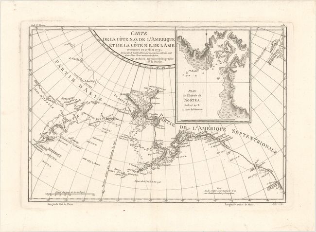
Auction 157, Lot 714
Subject: North Pacific Ocean
[Lot of 3] Carte de la Cote N.O. de l'Amerique et de la Cote N.E. de l Asie... [and] Plan de l'Entree de Nootka [and] Une Femme de l'Entree de Nootka, 1785-87
Size: See Description
Estimate: $120 - $150
NO RESERVE
Sold for: $90
Closed on 5/4/2016
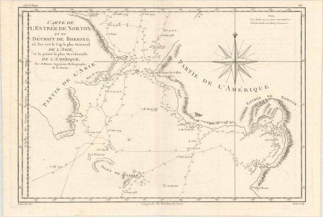
Auction 157, Lot 715
Subject: North Pacific Ocean
[Lot of 2] Carte de l'Entree de Norton et du Detroit de Bhering, ou l'on Voit le Cap le Plus Oriental de l'Asie, et la Pointe la Plus Occidentale de l'Amerique [and] Habitans et Habitations de l'Entree de Norton, 1785-88
Size: See Description
Estimate: $120 - $160
NO RESERVE
Sold for: $37
Closed on 5/4/2016
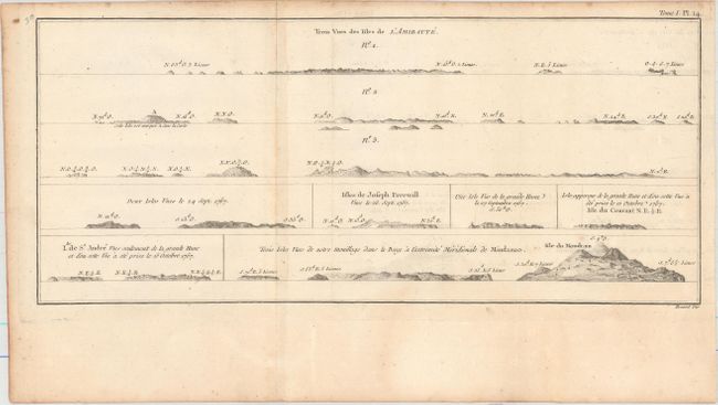
Auction 157, Lot 716
Subject: Admiralty Islands, Southern Philippines, South Sulawesi
Cook/Benard
[Lot of 3] Trois Vues des Isles de l'Amiraute... [and] Banc de Sable Dangereux... [on sheet with] Isles de Joseph Freewill [and] L'Extremite Meridionale de Mindanao [and] Vue de la Baye de Bonthain..., 1780
Size: See Description
Estimate: $100 - $130
NO RESERVE
Sold for: $42
Closed on 5/4/2016
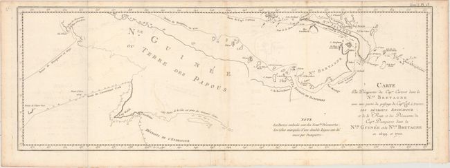
Auction 157, Lot 717
Subject: Papua New Guinea, New Britain, New Ireland, Nendo Island
[Lot of 4] Carte des Decouvertes du Capne. Carteret dans la Nle. Bretagne... [and] Nelle. Irlande [and] Cote Septentrional de la Plus Grande des Isles de la Reine Charlotte... [and] Isles de la Reine Charlotte, 1780-87
Size: See Description
Estimate: $140 - $170
NO RESERVE
Sold for: $70
Closed on 5/4/2016

Auction 157, Lot 718
Subject: Papua New Guinea & Solomon Islands
Dalrymple, Alexander
[Lot of 3] Plan of Carterets Harbour in St. Georges Sound New-Britain, 1767 [and] Plan of Byrons Bay on St. Cruz Island 1767 [on sheet with] Swallow, or Water Bay, on St. Cruz Island 1767 [and] Plan of Port Praslin..., 1781-82
Size: 8.7 x 11.2 inches (22.1 x 28.4 cm)
Estimate: $90 - $110
Sold for: $40
Closed on 5/4/2016
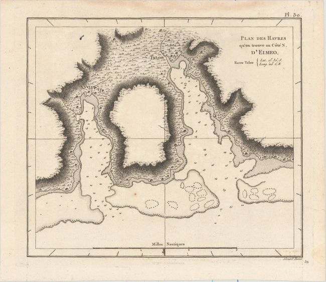
Auction 157, Lot 719
Subject: Society Islands
Cook, James (Capt.)
[Lot of 5] Plan des Havres qu'on Trouve au Cote N. d'Eimeo [and] Maniere dont on Expose les Morts a Otahiti [and] Vue de Huaheine [and] Hausse-Col Militaire des Insulaires de la Mer du Sud [and] Emouchoir des Otahitiens avec Ses Manches, 1780-85
Size: See Description
Estimate: $150 - $180
Sold for: $75
Closed on 5/4/2016

Auction 157, Lot 720
Subject: Cook Islands, French Polynesia
Cook/Benard
[Lot of 2] [I. Wenooa Ette/ I. Wateeoo/ Isle Mangeea/ Isle Toobouai] [and] Un Homme de Mangea, 1785
Size: See Description
Estimate: $110 - $140
NO RESERVE
Unsold
Closed on 5/4/2016

Auction 157, Lot 721
Subject: Tonga
Bonne, Rigobert
Carte des Isles des Amis, 1787
Size: 13.6 x 9.3 inches (34.5 x 23.6 cm)
Estimate: $100 - $130
Sold for: $50
Closed on 5/4/2016

Auction 157, Lot 722
Subject: Pacific Islands
Wilkes, Charles
[Lot of 4] Map of the Hawaiian Group or Sandwich Islands by the U.S. Ex. Ex. [and] Groups in the Western Part of the Pacific Ocean... [and] Map of the Sooloo Sea and Archiepelago... [and] Island of Tahiti, 1841-42
Size: 11.3 x 8.4 inches (28.7 x 21.3 cm)
Estimate: $150 - $180
Sold for: $110
Closed on 5/4/2016

Auction 157, Lot 723
Subject: Hawaii, New Zealand, Samoa, Fiji, Tonga, Society Islands, Marquesas Islands, Galapagos
Colton, G.W. & C.B.
Hawaiian Group or Sandwich Islands, 1855
Size: 12.9 x 15.8 inches (32.8 x 40.1 cm)
Estimate: $100 - $130
Sold for: $75
Closed on 5/4/2016
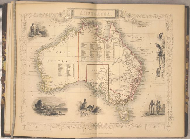
Auction 157, Lot 724
Subject: Australia
Martin, Montgomery
The British Colonies; Their History, Extent, Condition, and Resources Vol. II. Australia, 1855
Size: 7.8 x 11.1 inches (19.8 x 28.2 cm)
Estimate: $700 - $900
Sold for: $375
Closed on 5/4/2016
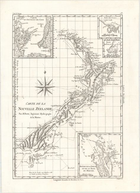
Auction 157, Lot 725
Subject: New Zealand
Bonne, Rigobert
Carte de la Nouvelle Zeelande, 1787
Size: 9.2 x 13.5 inches (23.4 x 34.3 cm)
Estimate: $800 - $950
Sold for: $600
Closed on 5/4/2016
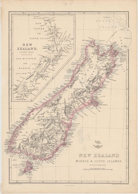
Auction 157, Lot 726
Subject: New Zealand
Dower, John
[Lot of 2] New Zealand North Island New Ulster or Eaheinomauwe [and] New Zealand Middle & South Islands, 1860
Size: 12.8 x 17 inches (32.5 x 43.2 cm)
Estimate: $160 - $190
Sold for: $100
Closed on 5/4/2016
21 lots