Filtered by Category:Canada(Show All Categories)
Showing results for:Auction 147
Catalog Archive
28 lots

Auction 147, Lot 99
Subject: Eastern Canada
Robert de Vaugondy, Didier
Carte Qui Represente Les Differentes Connoissances Que l'on a Eues des Terres Arctiques Depuis 1650 Jusqu'en 1747 Ausquelles il Faut Comparer La Carte Suivante, 1773
Size: 13.5 x 11.5 inches (34.3 x 29.2 cm)
Estimate: $120 - $160
Sold for: $40
Closed on 11/20/2013
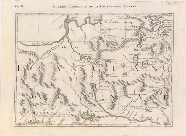
Auction 147, Lot 100
Subject: Eastern Canada
Zatta, Antonio
La Parte Occidentale della Nuova Francia o Canada, 1785
Size: 16.9 x 12.2 inches (42.9 x 31 cm)
Estimate: $200 - $230
Sold for: $90
Closed on 11/20/2013
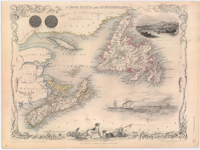
Auction 147, Lot 101
Subject: Eastern Canada
Tallis, John
[Lot of 2] Nova Scotia and Newfoundland [and] East Canada, and New Brunswick, 1850
Size: 13.4 x 10.1 inches (34 x 25.7 cm)
Estimate: $240 - $300
Sold for: $325
Closed on 11/20/2013

Auction 147, Lot 102
Subject: Nova Scotia & Prince Edward Island
Bellin, Jacques Nicolas
Carta dell' Acadia Isola Reale, e Paesi Vicini, 1781
Size: 12.8 x 8.1 inches (32.5 x 20.6 cm)
Estimate: $170 - $200
Sold for: $180
Closed on 11/20/2013

Auction 147, Lot 103
Subject: Halifax, Canada
A Plan of the Harbour of Chebucto and Town of Halifax, 1750
Size: 10.5 x 8.7 inches (26.7 x 22.1 cm)
Estimate: $700 - $850
The Porcupine Map
Sold for: $850
Closed on 11/20/2013
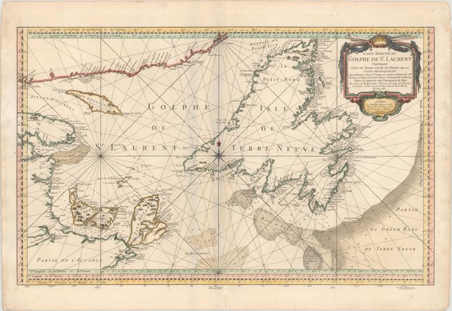
Auction 147, Lot 104
Subject: St. Lawrence Bay, Canada
Bellin, Jacques Nicolas
Carte Reduite du Golphe de St. Laurent Contenant l'Isle de Terre-Neuve et Partie de la Coste des Esquimaux..., 1754
Size: 33.4 x 20.8 inches (84.8 x 52.8 cm)
Estimate: $300 - $400
Sold for: $140
Closed on 11/20/2013
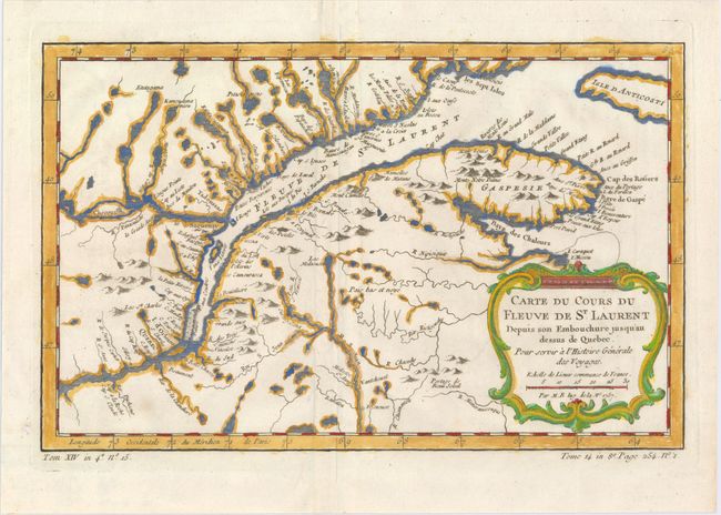
Auction 147, Lot 105
Subject: St. Lawrence River, Canada
Bellin, Jacques Nicolas
[Lot of 2] Carte du Cours du Fleuve de St. Laurent Depuis son Embouchure Jusqu'au Dessus de Quebec... [and] Cours du Fleuve de Saint Laurent Depuis la Mer Jusqu'a Quebec, 1757-64
Size: See Description
Estimate: $200 - $230
Sold for: $150
Closed on 11/20/2013
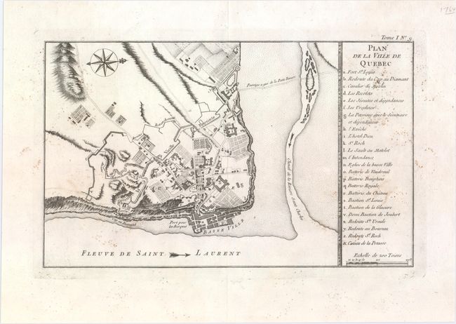
Auction 147, Lot 106
Subject: Quebec, Canada
Bellin, Jacques Nicolas
Plan de la Ville de Quebec, 1764
Size: 13.8 x 8.4 inches (35.1 x 21.3 cm)
Estimate: $140 - $170
Sold for: $70
Closed on 11/20/2013

Auction 147, Lot 107
Subject: Eastern United States & Canada
Ruscelli, Girolamo
Tierra Nueva, 1562
Size: 9.5 x 7.1 inches (24.1 x 18 cm)
Estimate: $1,200 - $1,500
Sold for: $900
Closed on 11/20/2013

Auction 147, Lot 108
Subject: Colonial Northeastern United States & Canada
Hondius/Bertius
Virginia et Nova Francia, 1618
Size: 5.4 x 3.8 inches (13.7 x 9.7 cm)
Estimate: $475 - $600
Unsold
Closed on 11/20/2013
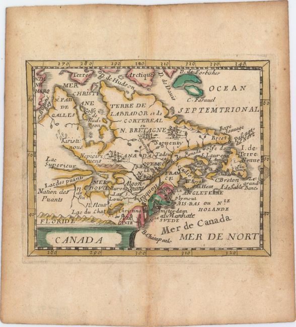
Auction 147, Lot 109
Subject: Colonial Northeastern United States & Canada
Duval, Pierre
Canada, 1682
Size: 4.8 x 3.9 inches (12.2 x 9.9 cm)
Estimate: $400 - $500
Unsold
Closed on 11/20/2013
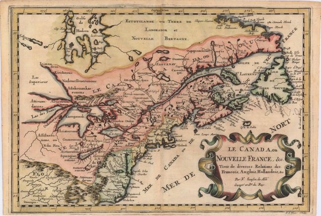
Auction 147, Lot 110
Subject: Colonial United States & Canada, Great Lakes
Sanson, Nicolas
Le Canada, ou Nouvelle France, &c. Tiree de Diverses Relations des Francois, Anglois, Hollandois, &c., 1683
Size: 11.9 x 8.2 inches (30.2 x 20.8 cm)
Estimate: $700 - $850
Small Version of a Keystone Map for Great Lakes Collections
Sold for: $650
Closed on 11/20/2013
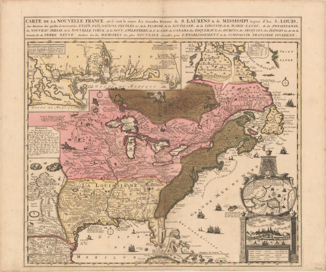
Auction 147, Lot 111
Subject: Colonial Eastern United States & Canada
Fer, Nicolas de
Carte de la Nouvelle France, ou se voit le cours des Grandes Rivieres de S. Laurens & de Mississipi, Aujour d'hui S. Louis…, 1719
Size: 21.7 x 19.6 inches (55.1 x 49.8 cm)
Estimate: $2,300 - $3,000
Striking Map of French Colonial Possessions
Unsold
Closed on 11/20/2013

Auction 147, Lot 112
Subject: Colonial United States & Canada
Le Beau, Claude
Carte du Canada Dediee a Son Altesse Serenissime Monseigneur [in book] Avantures du Sr. C. le Beau…, 1738
Size: 4 x 6.3 inches (10.2 x 16 cm)
Estimate: $1,000 - $1,200
Unsold
Closed on 11/20/2013
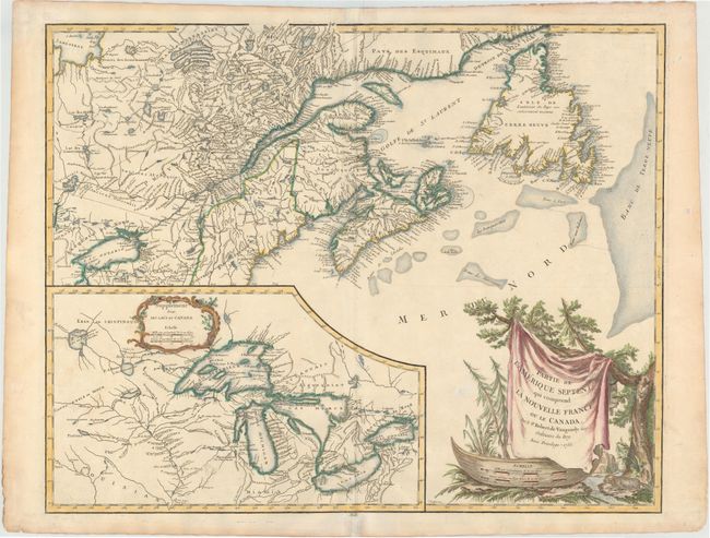
Auction 147, Lot 113
Subject: Colonial United States & Canada, Great Lakes
Robert de Vaugondy
Partie de l'Amerique Septent? qui Comprend la Nouvelle France ou le Canada, 1755
Size: 23.5 x 18.5 inches (59.7 x 47 cm)
Estimate: $700 - $850
Sold for: $375
Closed on 11/20/2013

Auction 147, Lot 114
Subject: Colonial United States & Canada
Anville, Jean Baptiste Bourguignon d'
[On 3 Sheets of 4] Canada Louisiane et Terres Angloises, 1755
Size: 21.9 x 18.8 inches (55.6 x 47.8 cm)
Estimate: $1,300 - $1,600
Sold for: $650
Closed on 11/20/2013
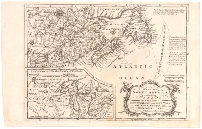
Auction 147, Lot 115
Subject: Colonial United States & Canada
Barrow, John (Sir)
Part of North America; Containing Canada, the North Parts of New England and New York; with Nova Scotia and Newfound Land, 1759
Size: 11.4 x 8 inches (29 x 20.3 cm)
Estimate: $140 - $180
Sold for: $90
Closed on 11/20/2013

Auction 147, Lot 116
Subject: Colonial United States & Canada
Gibson, John
A Particular Map, to Illustrate Gen. Amherst's Expedition, to Montreal; with a Plan of the Town & Draught of ye Island, 1760
Size: 8.8 x 7 inches (22.4 x 17.8 cm)
Estimate: $140 - $180
Sold for: $70
Closed on 11/20/2013
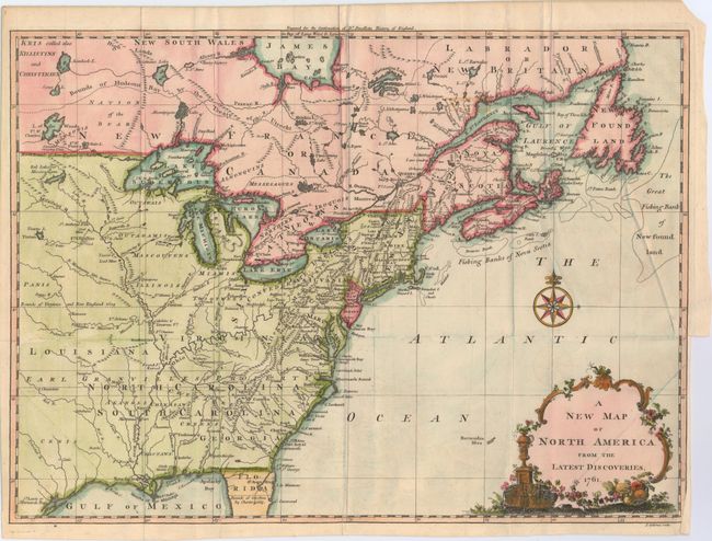
Auction 147, Lot 117
Subject: Colonial United States & Canada
Spilsbury, J.
A New Map of North America from the Latest Discoveries, 1761
Size: 15 x 10.9 inches (38.1 x 27.7 cm)
Estimate: $350 - $450
Sold for: $650
Closed on 11/20/2013
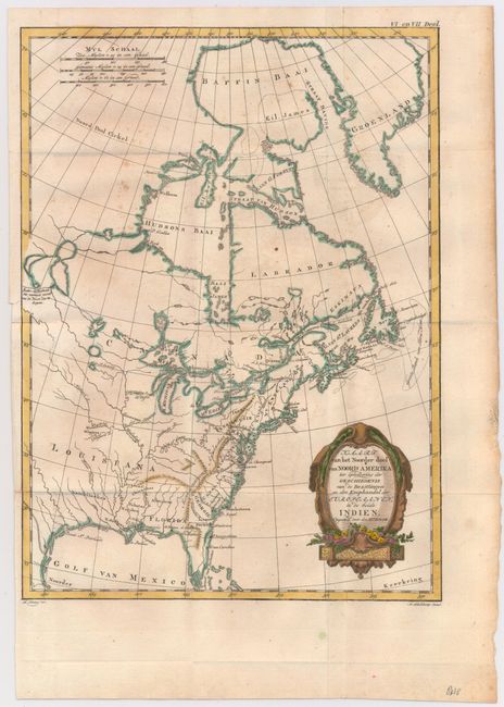
Auction 147, Lot 118
Subject: Colonial United States & Canada
Bonne, Rigobert
Kaart van het Noorder deel van Noord Amerika ter Opheldering der Geschiedenis van de Bezittingen..., 1778
Size: 9.2 x 12.5 inches (23.4 x 31.8 cm)
Estimate: $140 - $170
Sold for: $120
Closed on 11/20/2013

Auction 147, Lot 119
Subject: Colonial United States & Canada
Zatta, Antonio
L'Acadia, le Provincie di Sagadahook e Main, la Nuova Hampshire, la Rhode Island, e Parte di Massachusset e Connecticut, 1785
Size: 16.9 x 12.7 inches (42.9 x 32.3 cm)
Estimate: $300 - $375
Sold for: $200
Closed on 11/20/2013
Auction 147, Lot 120
Subject: Colonial New England & Canada
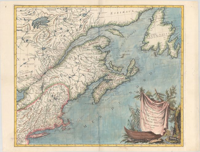
D'Anville/Santini
Partie Orientale du Canada, avec la Nouvelle Angleterre, l'Acadie, et la Terre-Neuve..., 1776
Size: 23.8 x 19.2 inches (60.5 x 48.8 cm)
Estimate: $400 - $500
Sold for: $700
Closed on 11/20/2013

Auction 147, Lot 121
Subject: Canada & United States
Tallis, John
British America, 1850
Size: 13 x 10.4 inches (33 x 26.4 cm)
Estimate: $140 - $170
Sold for: $200
Closed on 11/20/2013
Auction 147, Lot 122
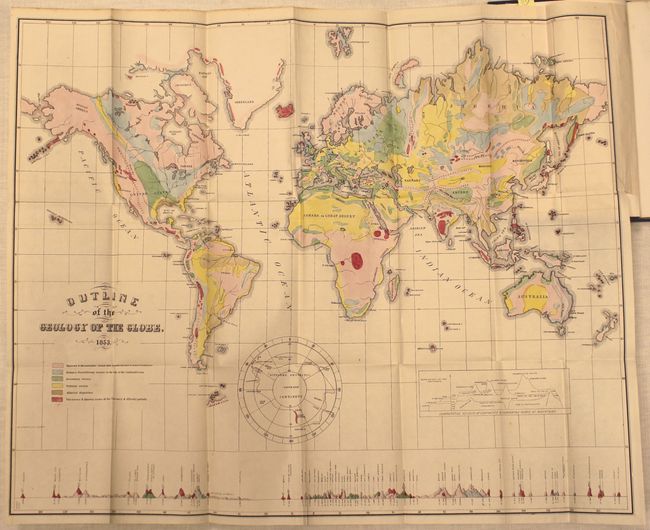
Subject: United States & Canada
Hitchcock, Edward
[Maps with Report] A Geological Map of the United States and Canada [and] Outline of the Geology of the Globe, 1853
Size: See Description
Estimate: $1,000 - $1,300
First Edition of Hitchcock's Important Maps and Report
Sold for: $1,300
Closed on 11/20/2013
Auction 147, Lot 123
Subject: Eastern United States & Canada
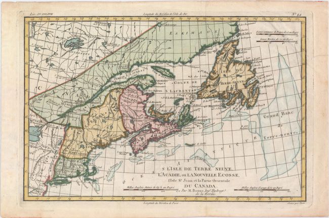
Bonne, Rigobert
L'Isle de Terre-Neuve, l'Acadie, ou la Nouvelle Ecosse, l'Isle St. Jean et la Partie Orientale du Canada, 1820
Size: 12.5 x 8.3 inches (31.8 x 21.1 cm)
Estimate: $200 - $230
Sold for: $150
Closed on 11/20/2013
Auction 147, Lot 124
Subject: Eastern United States & Canada
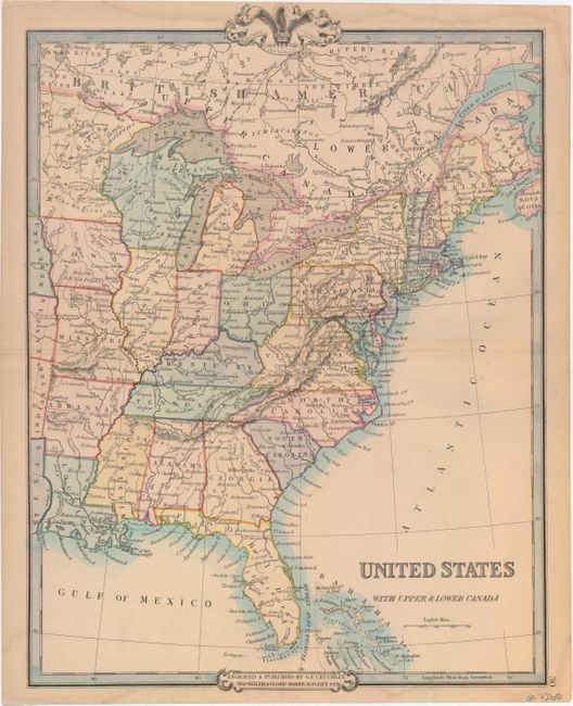
Cruchley, George Frederick
United States with Upper & Lower Canada, 1850
Size: 13.8 x 18.5 inches (35.1 x 47 cm)
Estimate: $90 - $120
Sold for: $50
Closed on 11/20/2013

Auction 147, Lot 125
Subject: Colonial Great Lakes
Bellin, Jacques Nicolas
Carte du Detroit Entre le Lac Superieur et le Lac Huron, avec le Sault Sainte Marie et le Poste de Michillimakinac..., 1744
Size: 6.3 x 8.4 inches (16 x 21.3 cm)
Estimate: $275 - $375
Sold for: $275
Closed on 11/20/2013

Auction 147, Lot 126
Subject: Colonial Great Lakes
Bellin, Jacques Nicolas
Carte des Lacs du Canada pour Servir a l'Histoire Generale des Voyages, 1757
Size: 11.5 x 7.8 inches (29.2 x 19.8 cm)
Estimate: $400 - $500
Sold for: $300
Closed on 11/20/2013
28 lots