Filtered by Category:Canada(Show All Categories)
Showing results for:Auction 145
Catalog Archive
27 lots
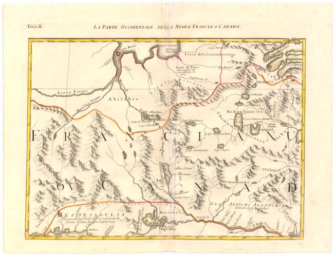
Auction 145, Lot 117
Subject: Eastern Canada
Zatta, Antonio
La Parte Occidentale della Nuova Francia o Canada, 1778
Size: 16.7 x 12.1 inches (42.4 x 30.7 cm)
Estimate: $220 - $275
Unsold
Closed on 6/12/2013
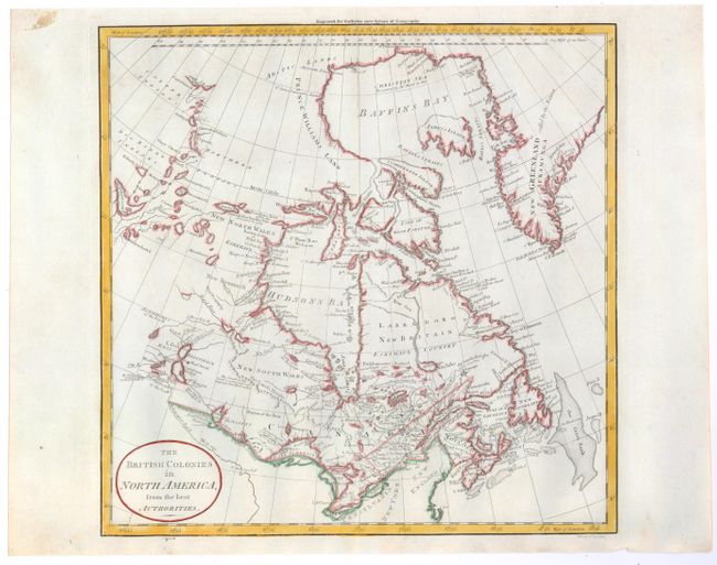
Auction 145, Lot 118
Subject: Eastern Canada
Guthrie, William
The British Colonies in North America, from the Best Authorities, 1795
Size: 13.3 x 13.2 inches (33.8 x 33.5 cm)
Estimate: $150 - $200
Sold for: $110
Closed on 6/12/2013
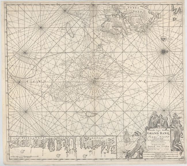
Auction 145, Lot 119
Subject: Newfoundland, Canada
Keulen, Gerard van
Nouvelle Carte Marine du Grand Banq de Terra Neuff a Grand Point…, 1728
Size: 22.5 x 20 inches (57.2 x 50.8 cm)
Estimate: $550 - $650
Sold for: $425
Closed on 6/12/2013
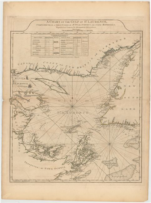
Auction 145, Lot 120
Subject: Gulf of St. Lawrence
Jefferys/Sayer & Bennett
A Chart of the Gulf of St. Laurence, Composed From a Great Number of Actual Surveys and other Materials, Regulated and Connected by Astronomical Observations, 1775
Size: 19.5 x 24 inches (49.5 x 61 cm)
Estimate: $450 - $550
Sold for: $325
Closed on 6/12/2013
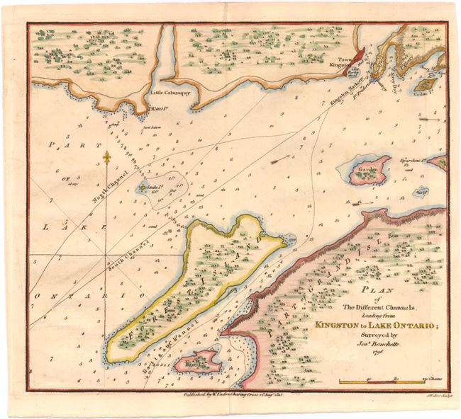
Auction 145, Lot 121
Subject: Lake Ontario
Faden, William
Plan of the Different Channels, Leading from Kingston to Lake Ontario; Surveyed by Josh. Bouchette. 1796, 1815
Size: 9.8 x 8.6 inches (24.9 x 21.8 cm)
Estimate: $160 - $200
Sold for: $160
Closed on 6/12/2013
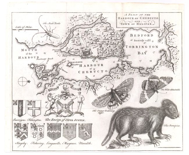
Auction 145, Lot 122
Subject: Halifax, Canada
A Plan of the Harbour of Chebucto and Town of Halifax, 1750
Size: 10.7 x 8.7 inches (27.2 x 22.1 cm)
Estimate: $750 - $850
The Porcupine Map
Sold for: $850
Closed on 6/12/2013
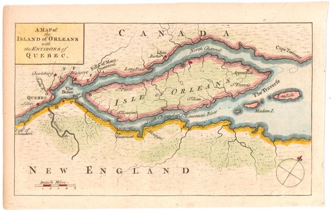
Auction 145, Lot 123
Subject: Quebec, Canada
Gentleman's Magazine
A Map of the Island of Orleans with the Environs of Quebec, 1759
Size: 7.3 x 4.2 inches (18.5 x 10.7 cm)
Estimate: $100 - $130
Sold for: $55
Closed on 6/12/2013
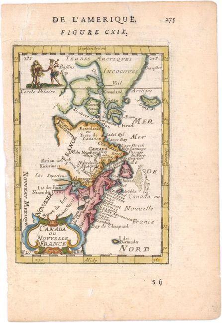
Auction 145, Lot 124
Subject: Colonial United States & Canada
Mallet, Alain Manesson
Canada ou Nouvelle France, 1683
Size: 4 x 5.6 inches (10.2 x 14.2 cm)
Estimate: $200 - $230
Sold for: $110
Closed on 6/12/2013
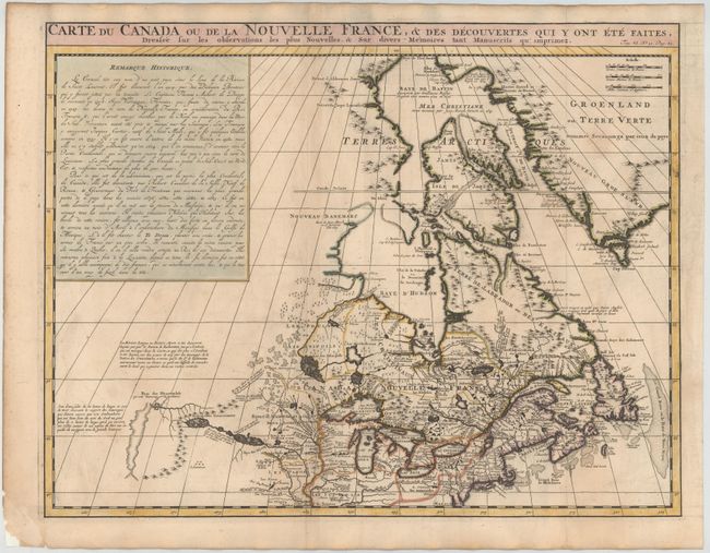
Auction 145, Lot 125
Subject: Colonial United States & Canada
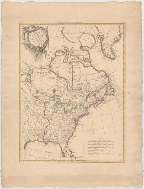
Chatelain, Henry Abraham
Carte du Canada ou de la Nouvelle France, & des Decouvertes qui y ont ete Faites, Dressee sur les observations les plus Nouvelles, & sur divers Memoires tant Manuscrits qu' imprimez, 1719
Size: 20.5 x 16 inches (52.1 x 40.6 cm)
Estimate: $900 - $1,100
Sold for: $650
Closed on 6/12/2013
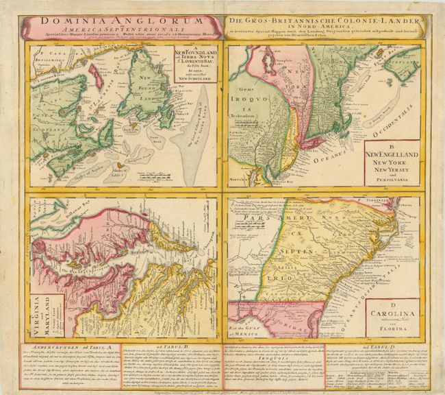
Auction 145, Lot 126
Subject: Colonial United States & Canada
Homann Heirs
Dominia Anglorum in America Septentrionali, 1740
Size: 21.5 x 19.8 inches (54.6 x 50.3 cm)
Estimate: $550 - $700
Sold for: $550
Closed on 6/12/2013
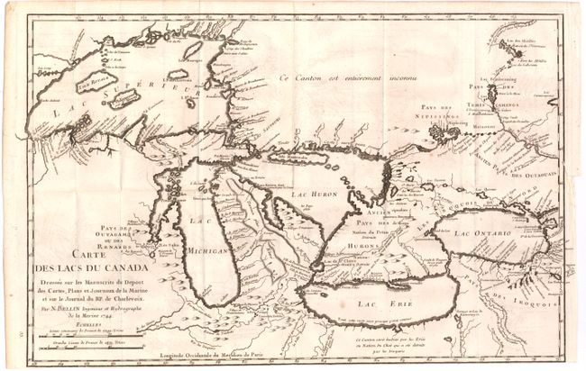
Auction 145, Lot 127
Subject: Colonial United States & Canada, Great Lakes
Bellin, Jacques Nicolas
Carte des Lacs du Canada…, 1744
Size: 17.2 x 11.2 inches (43.7 x 28.4 cm)
Estimate: $1,500 - $2,000
Bellin's Seminal Map of the Great Lakes
Sold for: $1,100
Closed on 6/12/2013
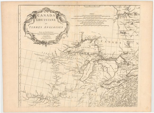
Auction 145, Lot 128
Subject: Colonial United States & Canada
Anville, Jean Baptiste Bourguignon d'
[On 3 Sheets of 4] Canada Louisiane et Terres Angloises, 1755
Size: 21.9 x 18.8 inches (55.6 x 47.8 cm)
Estimate: $1,500 - $2,000
Unsold
Closed on 6/12/2013
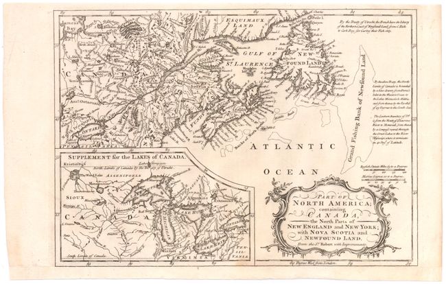
Auction 145, Lot 129
Subject: Colonial United States & Canada
Barrow, John (Sir)
Part of North America; Containing Canada, the North Parts of New England and New York; with Nova Scotia and Newfound Land, 1759
Size: 11.4 x 8 inches (29 x 20.3 cm)
Estimate: $160 - $200
Unsold
Closed on 6/12/2013
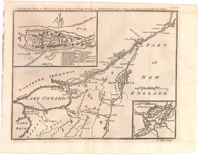
Auction 145, Lot 130
Subject: Colonial United States & Canada
Gibson, John
A Particular Map, to Illustrate Gen. Amherst's Expedition, to Montreal; with a Plan of the Town & Draught of ye Island, 1760
Size: 8.8 x 7 inches (22.4 x 17.8 cm)
Estimate: $160 - $200
Unsold
Closed on 6/12/2013
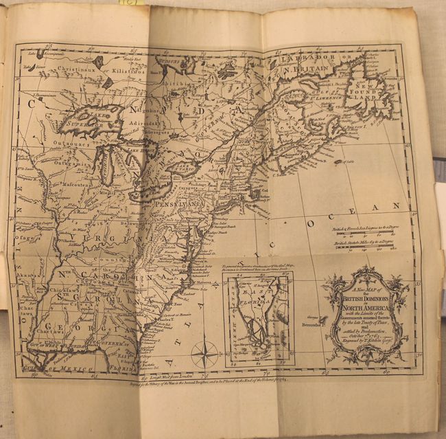
Auction 145, Lot 131
Subject: Colonial United States & Canada
Kitchin, Thomas
A New Map of the British Dominions in North America; with the Limits of the Governments Annexed thereto by the Late Treaty of Peace [in book] The Annual Register, or a View of the History, Politicks, and Literature, for the Year 1763, 1763
Size: 5.3 x 8.8 inches (13.5 x 22.4 cm)
Estimate: $550 - $700
Sold for: $300
Closed on 6/12/2013
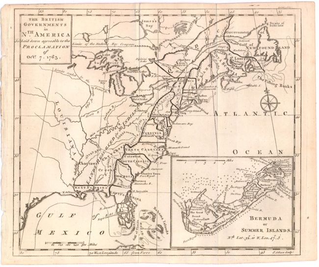
Auction 145, Lot 132
Subject: Colonial United States & Canada
Gibson, John
The British Governments in Nth. America Laid down Agreeable to the Proclamation of Octr. 7. 1763, 1763
Size: 9.3 x 8 inches (23.6 x 20.3 cm)
Estimate: $300 - $375
Sold for: $150
Closed on 6/12/2013
Auction 145, Lot 133
Subject: Colonial United States & Canada
Bonne/Lattre
Partie de l'Amerique Septentrionale, qui Comprend le Canada, la Louisiane, le Labrador, le Groenland, la Nouvelle Angleterre, la Floride &c., 1776
Size: 17 x 22.5 inches (43.2 x 57.2 cm)
Estimate: $550 - $750
Sold for: $400
Closed on 6/12/2013
Auction 145, Lot 134
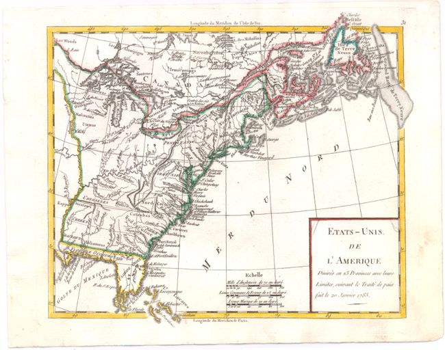
Subject: United States & Canada
Robert de Vaugondy
Etats-Unis de l'Amerique Divises en 13 Provinces avec leurs Limites, suivant le Traite de Paix Fait le 20 Janvier 1783, 1785
Size: 9 x 7.4 inches (22.9 x 18.8 cm)
Estimate: $160 - $200
Sold for: $120
Closed on 6/12/2013
Auction 145, Lot 135
Subject: United States & Canada
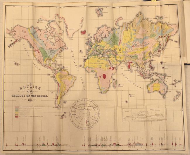
Hitchcock, Edward
[Maps with Report] A Geological Map of the United States and Canada [and] Outline of the Geology of the Globe, 1853
Size: See Description
Estimate: $1,000 - $1,300
First Edition of Hitchcock's Important Maps and Report
Unsold
Closed on 6/12/2013
Auction 145, Lot 136
Subject: Colonial Great Lakes
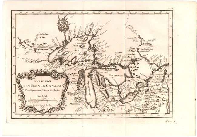
Bellin, Jacques Nicolas
Karte von den Seen in Canada Zur allgemeinen Historie der Reisen, 1757
Size: 11.2 x 7.5 inches (28.4 x 19.1 cm)
Estimate: $375 - $450
Sold for: $200
Closed on 6/12/2013
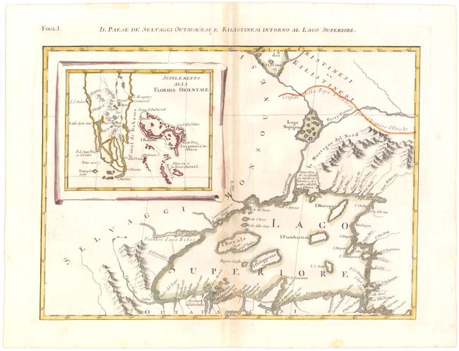
Auction 145, Lot 137
Subject: Colonial Great Lakes
Zatta, Antonio
Il Paese de' Selvaggi Outauacesi e Kilistinesi Intorno al Lago Superiore, 1778
Size: 16.5 x 12 inches (41.9 x 30.5 cm)
Estimate: $400 - $475
Sold for: $300
Closed on 6/12/2013
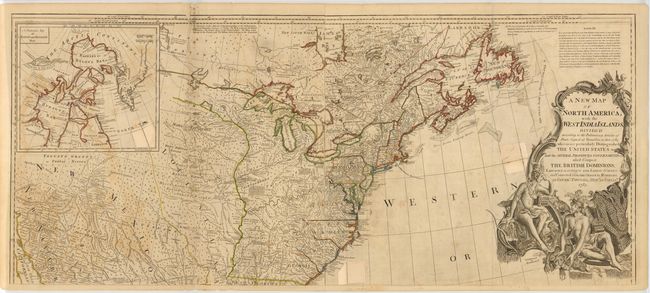
Auction 145, Lot 138
Subject: Eastern Canada & United States
Sayer, Robert
A New Map of North America; with the West India Islands..., 1783
Size: 46.3 x 20.1 inches (117.6 x 51.1 cm)
Estimate: $900 - $1,100
Sold for: $750
Closed on 6/12/2013
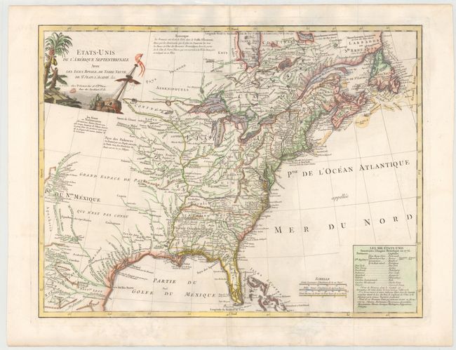
Auction 145, Lot 139
Subject: Eastern Canada & United States
Delamarche, Charles Francois
Etats-Unis de l'Amerique Septentrionale avec les Isles Royale, de Terre Neuve, de St. Jean, l'Acadie &c., 1785
Size: 24.6 x 18.7 inches (62.5 x 47.5 cm)
Estimate: $1,100 - $1,300
First Reference to Michigan as a Land Division of the US
Sold for: $650
Closed on 6/12/2013
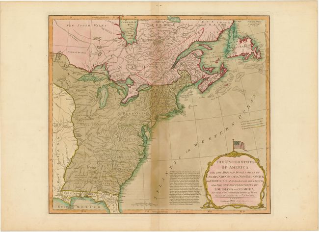
Auction 145, Lot 140
Subject: Eastern Canada & United States
Laurie & Whittle
The United States of America with the British Possessions of Canada, Nova Scotia, New Brunswick and Newfoundland Divided with the French, also the Spanish Territories of Louisiana and Florida According to the Preliminary Articles of Peace…, 1794
Size: 19.8 x 18 inches (50.3 x 45.7 cm)
Estimate: $900 - $1,100
Sold for: $450
Closed on 6/12/2013
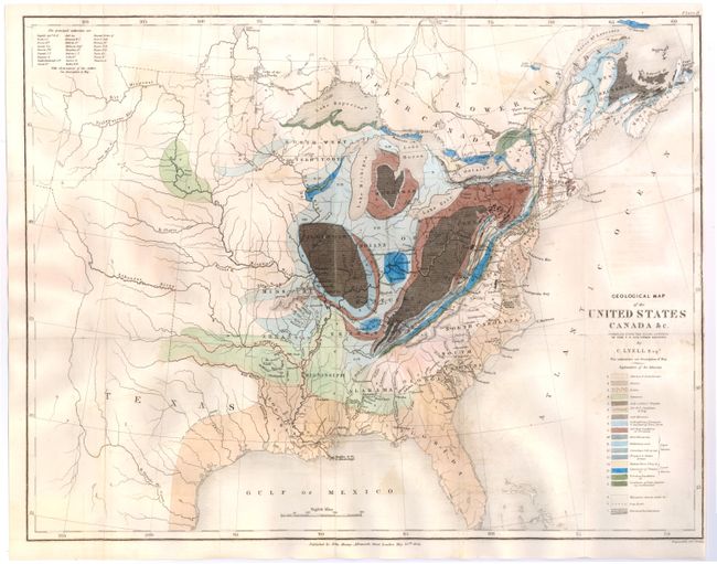
Auction 145, Lot 141
Subject: Eastern United States & Canada, Texas
Lyell, Charles
Geological Map of the United States Canada &c. Compiled from the State Surveys of the U.S. and Other Sources, 1845
Size: 19.6 x 15.1 inches (49.8 x 38.4 cm)
Estimate: $400 - $500
Sold for: $300
Closed on 6/12/2013
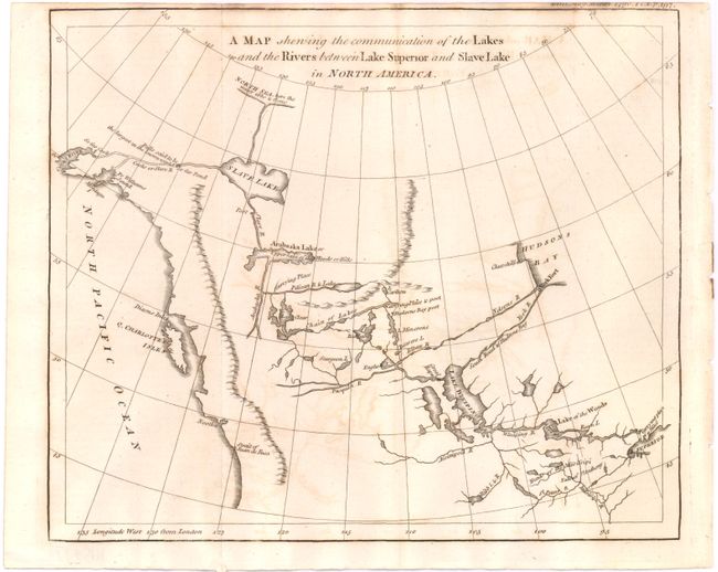
Auction 145, Lot 142
Subject: Western Canada & Alaska
Anon.
A Map Shewing the Communication of the Lakes and the Rivers Between Lake Superior and Slave Lake in North America, 1790
Size: 9.3 x 7.8 inches (23.6 x 19.8 cm)
Estimate: $275 - $350
Sold for: $160
Closed on 6/12/2013
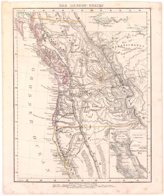
Auction 145, Lot 143
Subject: Western Canada & United States
Flemming, Carl
Das Oregon-Gebiet, 1848
Size: 12.7 x 16 inches (32.3 x 40.6 cm)
Estimate: $240 - $300
Sold for: $180
Closed on 6/12/2013
27 lots