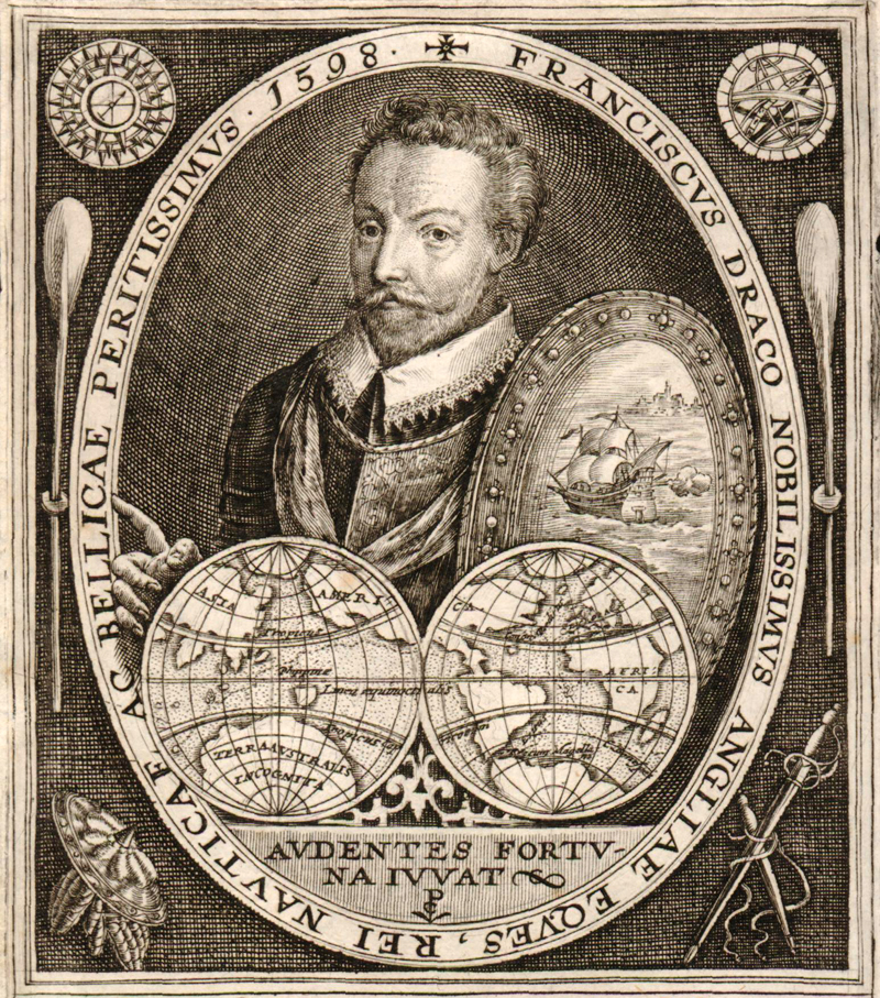
This portrait of Drake and his ship, the Golden Hind, was published in Crispin de Passe’s rare Effigies Regum ac Principum… (1598), a work on the circumnavigation journeys of Drake and Cavendish.
Mapping Drake
by Joe McAlhany
The history of cartography and the history of exploration are inextricably linked. The great explorers used existing maps to plan and navigate their voyages, and their discoveries eventually wound up appearing on new maps that then influenced future expeditions. In our January newsletter, we retraced the route of Ferdinand Magellan’s circumnavigation of the globe (1519-22), identifying maps that showcase the places discovered along the way. This month we will continue that series by looking at Sir Francis Drake’s trip around the world from December 1577 to September 1580 and how his journey was reflected on a variety of maps.
The great English circumnavigator’s origin story varies depending on the account, but here is the most plausible telling we could assemble. Francis Drake was born on the Crowndale farm near Tavistock, West Devon, most likely in February or March 1540, although some estimates date his birth as late as 1544. The sea was in his blood: his father Edmund had been a sailor before becoming a tenant farmer, shearman, and preacher. Although several accounts state that Edmund was forced to decamp due to anti-Protestant religious persecution, the truth was that he was a fugitive from the law after a couple of violent robberies. But by the time his father was on the lam, Francis was already living with the Hawkins family, prosperous relatives who trained the young man in the art of seafaring.
The Hawkins were successful merchants, but, as was common practice during this era, they were also privateers or pirates, plundering French, Spanish, or Portuguese vessels on the side for extra lucre. Drake was initiated into this unsavory but generally accepted business while still in his teens. In the 1560s, Drake joined his second cousin Sir John Hawkins on a series of voyages to Guinea. On these voyages, Hawkins made his brutal entry into the Atlantic slave trade, becoming the first English merchant to profit from selling captured Africans to Spanish colonies in the West Indies. In September 1568, on Drake’s last slave trading voyage with Hawkins, they were ambushed by the Spanish in the Battle of San Juan de Ulúa. Drake made his escape on a small ship called the Judith, while hundreds of Englishmen were captured or killed and much of their loot taken (or taken back) by the Spanish. Only one other English ship escaped, the Minion, piloted by Hawkins himself. Hawkins felt betrayed and abandoned by his younger cousin. Yet despite his bitter disappointment, Hawkins was later one of the investors in Drake’s circumnavigation voyage.
The direct aftermath of the Battle of San Juan de Ulúa, is disputed; according to Spanish historian Antonio de Herrera, Drake was imprisoned for a few months upon his return to England, suspected of keeping much of the treasure aboard the Judith. Whether or not he was locked up, Drake eventually returned to the seas for more privateering missions. In May 1572, he struck out for his first independent voyage, a raid on Spanish silver and gold in Panama. By the time he returned to Plymouth in August 1573, one of the two ships he departed with had been scuttled and more than half of his original 73-man crew was dead, including his own brothers, John and Joseph. But Drake had also come back with two captured frigates, £20,000 in profits, and a reputation among the Spanish as a pirate to fear.
Tensions were already high between Elizabeth I’s England and Philip II’s Spain when Drake commenced his seafaring career in the late 1550s, but by the 1570s, relations were teetering on the brink of out-and-out war. Under Elizabeth, England had significantly expanded its presence on the high seas. In addition to expanding trade, Elizabeth began to embrace maritime conflict as an effective strategy for weakening England’s enemies with little risk of bloodshed at home or significant loss of money, military supplies, or manpower. Even when their deeds were not officially sanctioned, privateers like Drake performed a valuable service by picking off Spanish ships and colonies and pillaging their treasure.
It was in this context that the scheme was hatched for Drake’s “Famous Voyage.” The passive voice there is no accident – due to the secrecy and generally poor documentation surrounding the planning of Drake’s circumnavigation, it is difficult to say for certain who exactly plotted out the voyage, or what all they hoped to accomplish. Was it intended to be a merchant’s voyage to establish new trading relationships in southern South America, the Moluccas, or China? An attempt to found a new English colony for Protestants along the western coast of North America? A search for the Northwest Passage? A repetition of Magellan’s circumnavigation? Historians have offered various guesses over the centuries, but the consensus among contemporary historians is that the primary aim of the trip was piratical. Drake’s task was to conduct surprise raids on Spanish ports and settlements along the Pacific. Whether or not Elizabeth explicitly approved of such a mission at the outset is somewhat ambiguous – although Drake claimed the queen invested £1,000 of her own money into the voyage. Regardless, she was certainly pleased with the riches acquired on the trip upon Drake’s return.
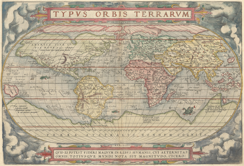
After their initial departure was thwarted by a squall in November 1577, Drake and his crew set sail from Plymouth on December 13, 1577. His fleet was comprised of five ships: the Pelican, captained by Drake; the Elizabeth, captained by Drake’s Vice-Admiral John Wynter; the Marigold; the Swan, a poorly constructed provision ship; and the Benedict, a pinnace. The crew numbered roughly 170 men. At the outset of the voyage, the crew believed that they were bound for Alexandria; the pirate mission was obscured from them. It is said that Drake consulted the maps of Ortelius along his journey, including his great world map "Typus Orbis Terrarum" (1570).
Drake supposedly brought a copy of Ortelius’ "Typus Orbis Terrarum" (1570) on his journey around the world.
The first leg of the journey traced the western coast of Saharan Africa. Drake was capturing foreign ships right out of the gate, taking three Spanish fishing boats and a trio of Portuguese caravels before his fleet hit the Cape Verde Islands, perhaps cluing in the crew that this was no mere mercantile expedition. Off the coast of Santiago, the largest of the Cape Verde Islands, Drake’s men seized the Santa Maria, a Portuguese merchant carrack loaded with bread, wine, velvet, and swords. But even more valuable than the luxurious cargo was the ship’s pilot Nunho da Silva, a seasoned veteran of several trips to the Americas who knew the Atlantic’s winds and currents very well. What more could a crew ask for as they set off across the ocean? Da Silva was taken as a prisoner – albeit one who was treated with the utmost respect by Drake, who wanted to keep the Portuguese pilot happy – and command of the Santa Maria (now rechristened the Mary) was given to Thomas Doughty, a wealthy nobleman and an old friend of Drake’s.
This engraving from De Bry’s Grands Voyages (circa 1599) shows Drake’s return to Santiago in 1585, en route to his assault on Spanish colonies in the New World.
The protracted and oppressively hot journey across the Atlantic was extremely tough on the crew. Drama erupted in the tedium as the relationship between Drake and Doughty grew increasingly strained, seemingly over gossip and petty squabbles that undermined Drake’s fragile authority. Drake accused the nobleman, without much basis in fact, of conspiring to overthrow him and making treasonous statements against the queen. When the fleet harbored in Port St. Julian in Patagonia in June 1578, Doughty was put on trial and found guilty. On July 2, 1578, he was beheaded after receiving communion and dining with Drake himself.
Drake’s fleet wintered in Port St. Julian for six weeks, just as Magellan did in 1520. After Doughty’s unjust execution, morale among the men was dismal, with the bitter cold only further exacerbating the misery. Drake reasserted his control with a lengthy speech wherein he decreed that sailors and gentlemen would work side by side as equals under his authority. He then relieved the officers of their command and then immediately reinstated them, making it clear that they were now hisappointees and not those of the trip’s investors. At this point, Drake also unveiled what most of the crew had already begun to suspect: they were part of a pirate mission to steal Spanish treasure.
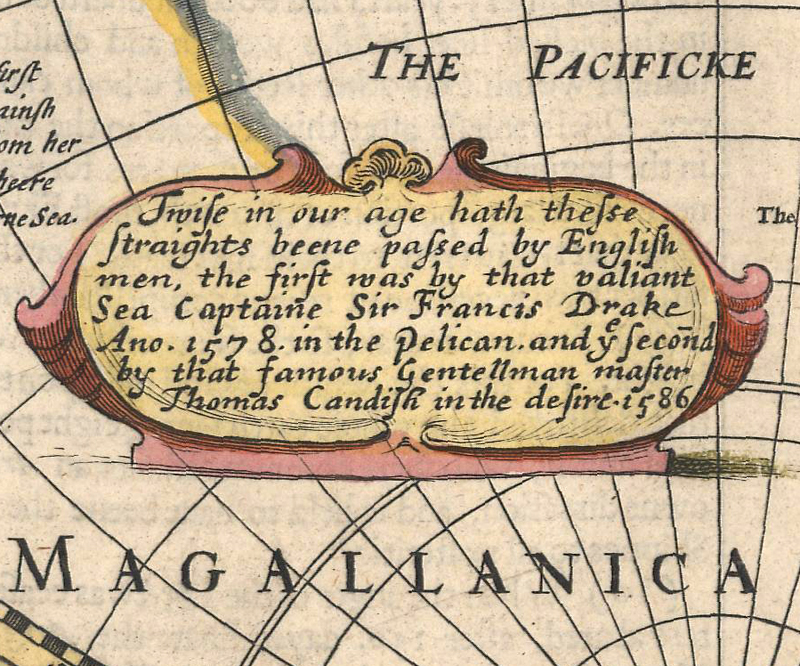
Speed’s iconic world map (1626) commemorates Drake’s passage through the Strait of Magellan: “Twise in our age hath these Straights beene passed by English men, the first was by the valiant Sea Capitaine Sir Francis Drake Ano 1578 in the Pelican…” It also includes a portrait of the pirate-explorer.
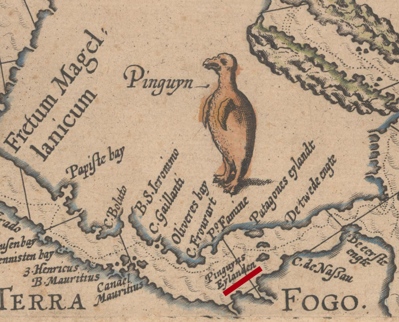
From Port St. Julian, the squadron, now consisting of just three ships (the Pelican, the Marigold, and the Elizabeth) proceeded toward the Strait of Magellan. Legend has it that along the way to the strait, Drake renamed the Pelican the Golden Hind, after the female red deer on the family crest of his patron, Sir Christopher Hatton. Contemporaneous evidence suggests that the ship was still widely referred to as the Pelican until after Drake’s death, but the name of the Golden Hind is now practically synonymous with the circumnavigation. Being the only ship to survive the journey from beginning to end, the Golden Hind served as a symbol of Drake’s seafaring prowess. On August 20, 1578, the ships began their passage through the Strait of Magellan. According to the account of Francis Fletcher, the Golden Hind’s chaplain, Drake discovered three small islands on the 24th that he named Elizabeth, Bartholomew, and George, where the hungry crew were able to hunt penguins. When Thomas Cavendish navigated the strait in 1587 using Drake’s maps, he noted just two of Drake’s islands: Bartholomew and a second one that he referred to as “Penguin Island.” While these islands appear only as the Penguin Islands on 17th-century maps of the Strait of Magellan, the Fletcher nomenclature is shown on later 18th-century maps by De Fer and Bellin.
Drake's "Pinguyns Eylanden" (underlined in red) as they appear on Baptista van Doetichum's "Fretum Magallanicum in quod Olivier a Noort..." (1646), a map chronicling Oliver van Noort's 1602 passage through the strait.
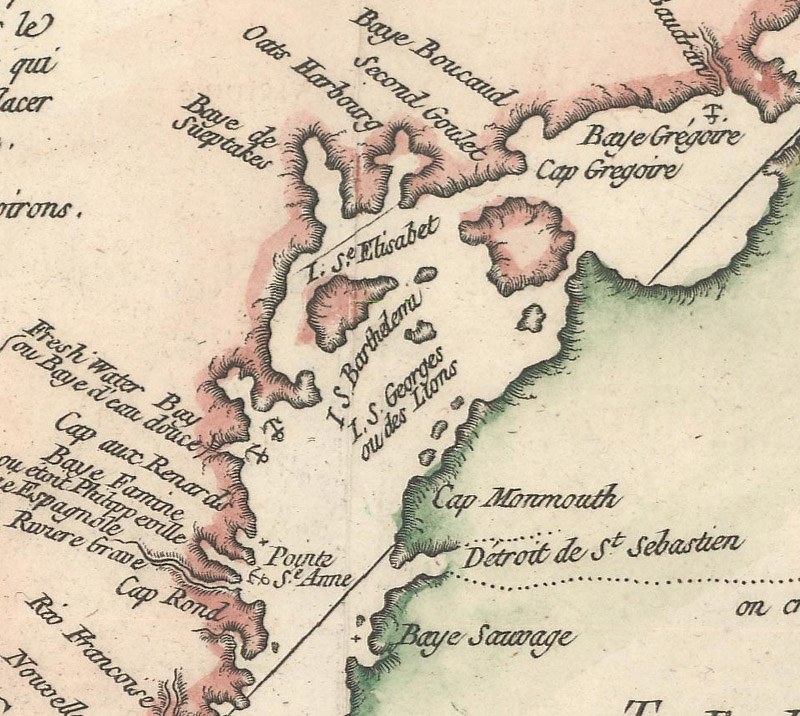
Bellin’s map of the strait, "Carte Reduite du Detroit de Magellan Dressee sur les Journaux des Navigateurs" (1753), shows the islands of Elizabeth, Bartholomew, and George.
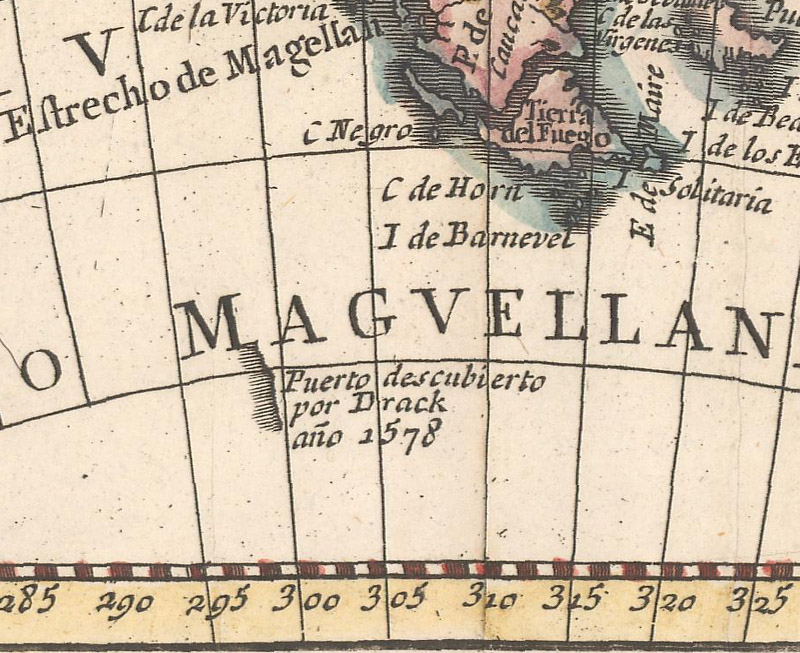
The fleet emerged into the Pacific on September 6, after a 16-day passage through the strait. They were immediately swept up into a series of storms and mistakenly navigated farther into the ocean rather than towards land. In the chaos and confusion, the Marigold disappeared and the Elizabeth, still under the command of John Wynter, separated from the Golden Hind and eventually made its way back to England, where Wynter was jailed for desertion. The Golden Hind was knocked south by the storm, allegedly to the 56° or 57° south latitude, south of Tierra del Fuego, where he supposedly found a group of islands he dubbed the “Elizabethides.” As a result of this questionable discovery, Drake is often credited with dispelling the myth that Tierra del Fuego was attached to Terra Australis, the mysterious southern continent. After all, the stretch of ocean between Tierra del Fuego and Antarctica is now called the Drake Passage. But a closer look at the facts suggests that this belief is the remnant of misinformation and propaganda.
Pedro Gendron's "La America Dispuesta Segun las Ultimas..." (circa 1756) is one of several maps to attribute to Drake a vague stretch of coastline south of Tierra del Fuego.
When Wynter returned to England in June 1580, the English government began to claim that Wynter had gone around the southern tip of Tierra del Fuego rather than passing through the Strait of Magellan again. However once Drake returned to Plymouth in September 1580, the official account changed: it was actually Drake who had sailed around the cape from the Pacific to the Atlantic! The English were copying from extensive reports from Spanish navigators who had charted the region and all but definitively proved that Tierra del Fuego was an island – without crediting the Spanish, of course. In fact, part of the purpose of these claims seemed to be to agitate the Spanish by attributing the discovery to an Englishman. Book collector, historian, and cartographer Henry Wagner theorizes that the “Elizabethides” that Drake stumbled upon were likely just a small island well to the northwest of Cape Horn. Most historians agree that it is exceedingly unlikely that Drake located the passage that now bears his name. But contemporary Drake chronicler Harry Kelsey puts a positive spin on Drake’s dubious “discovery”: “He started a widespread discussion of information that had been gathered by earlier Spanish expeditions, and he popularized the idea that there might be an open channel south of Tierra del Fuego.”
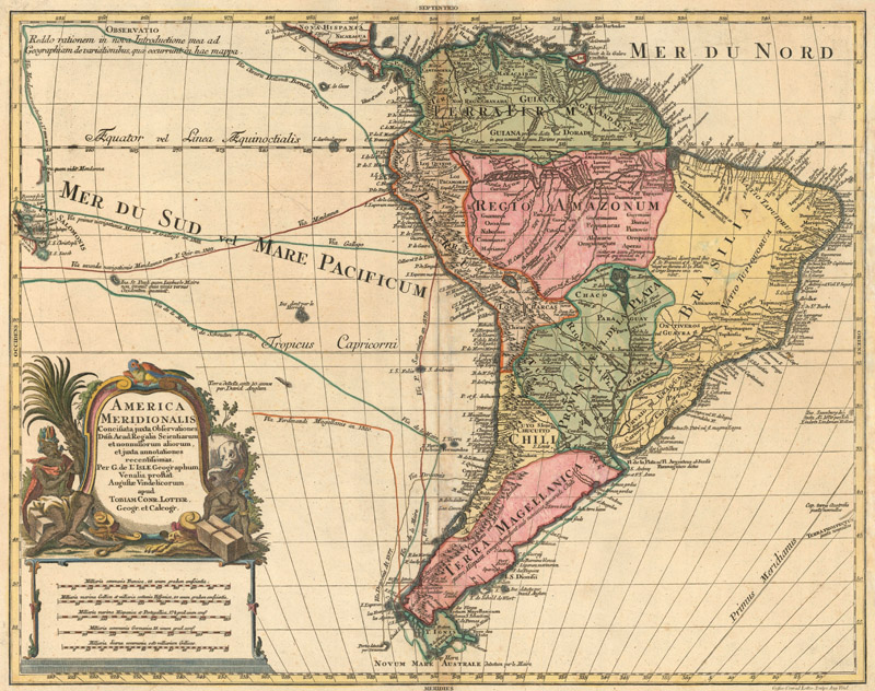
Tobias Conrad Lotter’s "America Meridionalis…" (circa 1772) depicts Drake’s track up the western coast of South America, proceeding from a fragment of coastline west of Tierra del Fuego that is labeled “Portus detectus per Draconem.”
On October 28th, Drake began his slow crawl up the western coast of South America. With just 80 men left on the Golden Hind, the great pirate began to attack various ports along the way, capturing food, supplies, detailed Spanish navigational charts, and, most important of all, gold. When he pulled into Callao, the port of Lima, in February 1579, he was greeted with news of a Spanish treasure ship bound for Panama. The Golden Hind chased after the galleon, named the Nuestra Señora de la Concepción (nicknamed the Cacafuego), and seized her within two weeks. The haul inside amounted to millions in gold and silver. It was the biggest take of the journey and a guarantor that, despite the difficulties thus far, Drake’s voyage would be viewed by his backers and the queen as a success.
Now that he had scored his prize and secured his reputation, Drake was ready to head home. In April 1579, Drake entered the sparsely populated port of Hualteco in Oaxaca, Mexico. After quickly ransacking the town, Drake made an odd move: he cut loose his pilot Nunho da Silva on a deserted ship – but not before telling him of a crucial change in his plans. Originally, the voyagers were to return to England via the route through the Moluccas, but Drake told da Silva that he now intended to travel north in search of the fabled Strait of Anian. The earliest detailed chronicle of the voyage, The World Encompassed, compiled by Drake’s nephew and published in 1628, also makes the claim that Drake sailed north in search of the Northwest Passage. It is certainly true that Drake went north, but it is improbable that his true motives were to find the Strait of Anian. Such an uncertain expedition would have been extremely risky given the amount of treasure on board. Drake knew that the Spanish had a target on his back. By telling da Silva of a plan to continue northward, he was hoping to throw the Spanish off his trail.
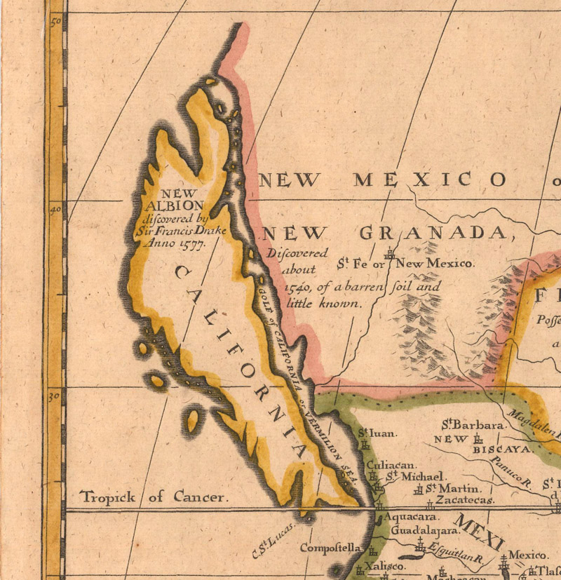
“New Albion discovered by Sir Francis Drake Anno 1577” appears on the northern tip of the island of California on Edward Wells’ "A New Map of North America…" (circa 1704).
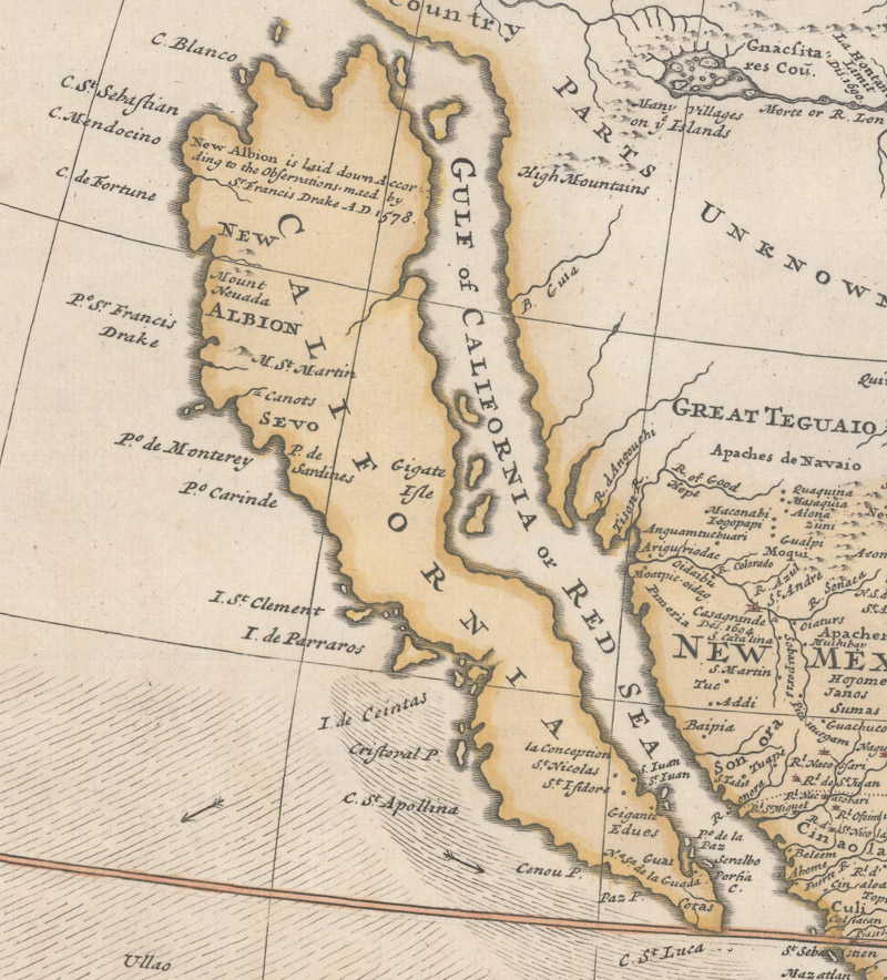
“New Albion is laid down According to the Observation maed by Sr. Francis Drake AD 1578” is noted on Herman Moll’s famous “Codfish Map” (circa 1755).
So why did he wind up actually sailing north instead of setting out across the Pacific and heading for the Moluccas? The elements were literally against him. The optimal conditions for sailing across the Pacific, the winter winds of October or November, were still six long months away, and vengeful Spanish warships were in pursuit. Drake sailed west to evade scraps with enemy vessels and then was forced to ride the winds north, perhaps venturing as far as the Alaskan Panhandle. After 50 days at sea, the Golden Hind was badly battered, with a punctured hull and dwindling stores of food and water. Traveling east towards land, Drake anchored briefly in a “bad bay” covered in “the most vile, thicke and stinking fogges,” as the landing is described in The World Encompassed. Finding the conditions there wanting, Drake headed south to a more hospitable harbor. It was here that he made the great discovery of his voyage: the land he proudly called “Nova Albion” (in a nod to Great Britain’s ancient name) in present-day Upper California.
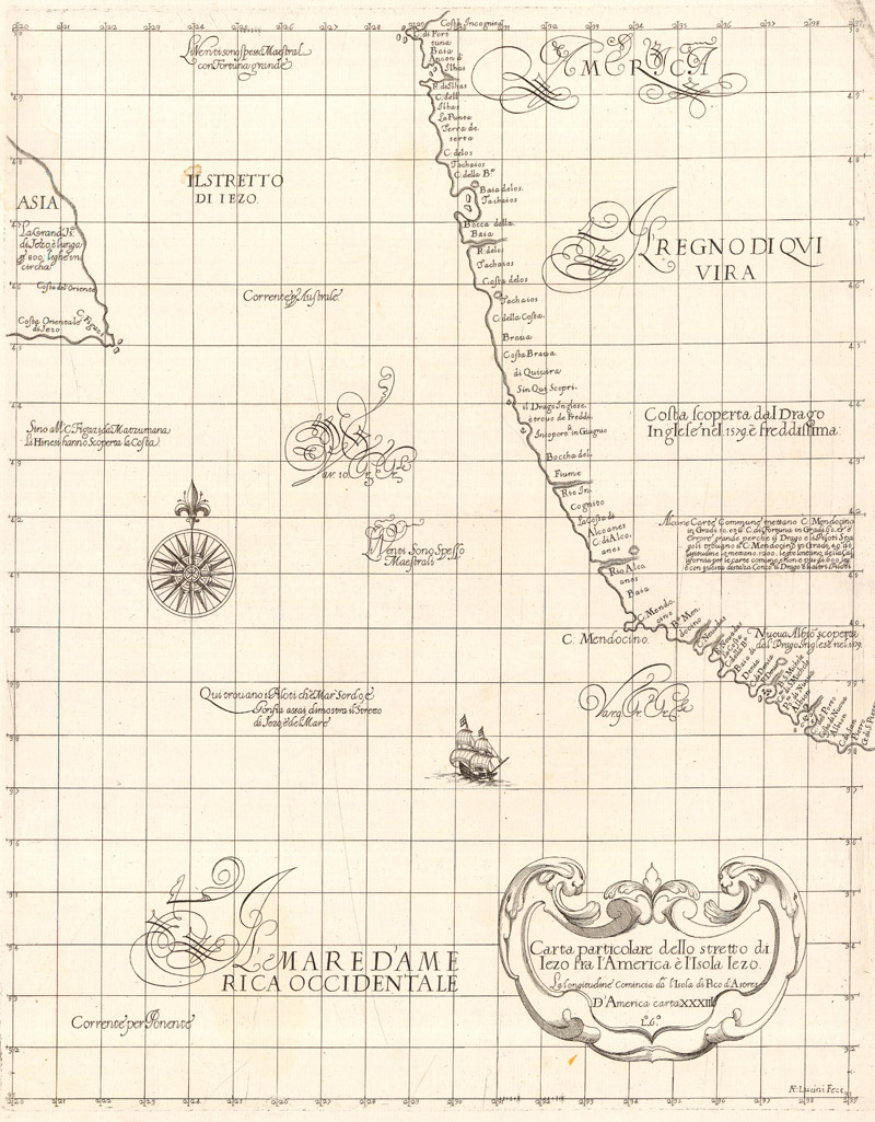
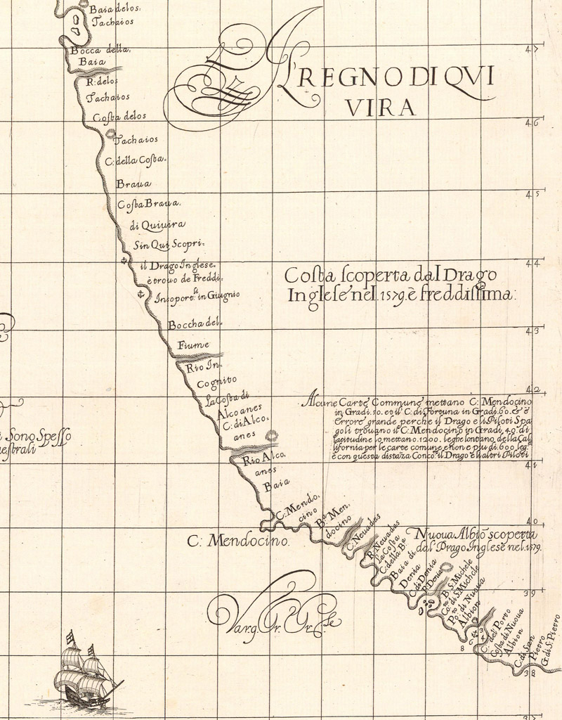
Sir Robert Dudley’s "Carta Particolare…" (1647) is a key text in determining where Drake landed in Upper California.
A closer look at Drake’s discoveries as depicted on the Dudley map
As with so much of Drake’s circumnavigation, the exact location of his landing has never been confirmed. Most theories place Drake’s harbor somewhere near today’s Drakes Bay, just north of San Francisco. Sir Robert Dudley’s "Carta Particolare dello Stretto di Iezo fra l’America e l’Isola Iezo" (1647), from Dell’ Arcano del Mare, his groundbreaking maritime atlas of the world, is a key text in understanding Drake’s position. Dudley was the illegitimate son of Robert Dudley, 1st Earl of Leicester, who was a suitor to Elizabeth and one of the major investors in Drake’s voyage. It is possible, therefore, that the younger Dudley had access to first-hand information that few others had seen. Dudley’s map locates a harbor called “Pto. De Nuova Albion” near 39° north latitude, with a note next to it that reads, “Nuova Albio scoperta dal’ Drago Inglese nel 1579” (“Nova Albion discovered by the Englisman Drake in 1579”). This roughly aligns with Drakes Bay. Further north, near present-day Coos Bay, Oregon, there is an anchorage with notes nearby of a wild and frigid coast discovered by Drake in the land of Quivira. Does this mean Coos Bay is the mysterious “bad bay” where Drake first anchored? Drake’s nephew, John Drake, claimed that the initial landing was much closer to present-day Vancouver, but the conflicting accounts have never been resolved.
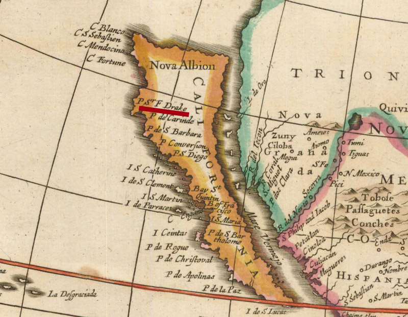
John Ogilby's "Novissima et Accuratissima Totius Americae Descriptio" (circa 1671) is the first map to identify "P Sr F Drake" on Nova Albion, locating it well to the north of San Francisco Bay on an insular California.
On July 23, 1579, after a five-week sojourn in California, Drake ventured back into the Pacific. Despite all the potential dangers lurking in the hostile waters of the “Spanish Lake,” it was a relatively uneventful return voyage, at least when it came to run-ins with enemy ships. The Golden Hind adhered to the well-worn route established by the Manila galleons. By October, Drake and company were in the Philippines, and in November, they were in Ternate, striking a trade deal with Sultan Babullah, a shrewd leader eager to enter into an arrangement with a rival of the Spanish and Portuguese. Drake traded the sultan linen for six tons of cloves and various other spices and provisions, all of which was thrown into the sea to lighten the ship after the Golden Hind snagged on a reef near the Celebes in January 1580. Loosed from the reef, the ship headed towards Java, where the crew stopped for two weeks and acquired several tons of food. From March 24th to June 15th, the voyage sailed the open sea from Java around the Cape of Good Hope. Three and a half months later, on September 26th, 1580, Drake and his men finally anchored in Plymouth again. Drake had successfully circumnavigated the globe, the first Englishman to accomplish the feat and the very first man to command such a voyage from beginning to end.
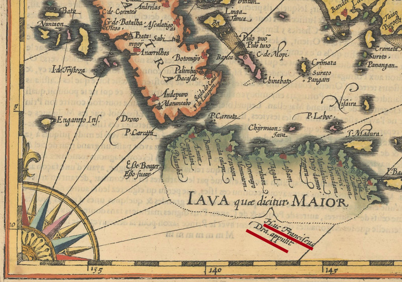
Mercator/Hondius' "Insulae Indiae Orientalis Praecipuae..." (1609) is one of the few maps to show any trace of Drake's explorations in Southeast Asia. A bay is located on the incomplete southern coastline of Java with a note stating Drake landed there.
It was a triumphant achievement, but the initial response upon Drake’s return was cautious, muted. The queen and many powerful Englishmen were uneasy with Drake’s flagrant acts of piracy, especially with the Spanish insisting on justice for their losses. But Drake’s bountiful score – the voyage netted an astonishing profit of 4,600%! – ensured his amnesty and, beyond that, his reputation as an English national hero. Elizabeth knighted Drake on April 4th, 1581, appropriately enough on the deck of the Golden Hind. Sir Francis Drake may have been a pirate, but he was also now officially celebrated as a gentleman, a great sea captain, and the first Englishman to travel around the globe.
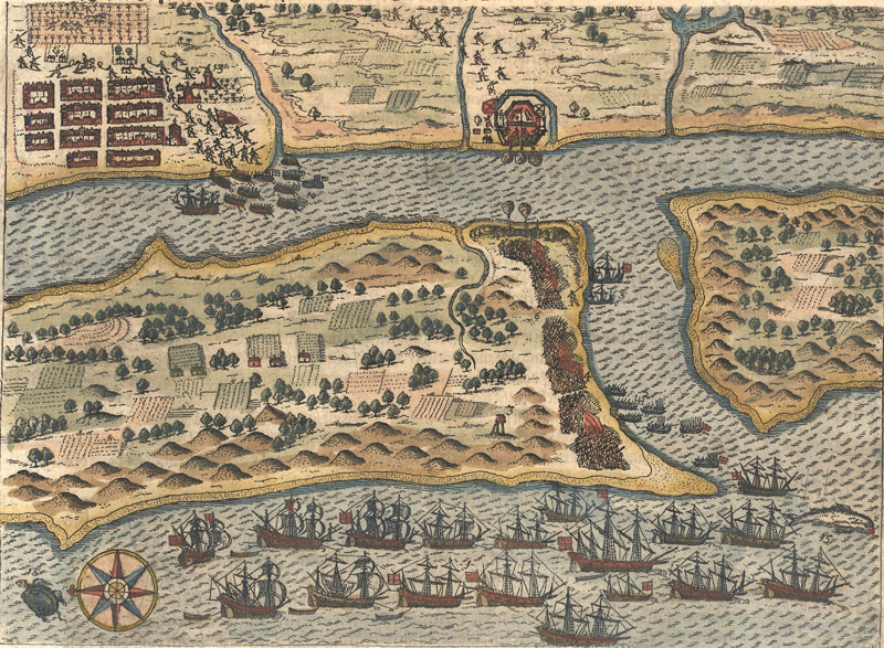
This engraving from Part VIII of De Bry’s Grands Voyages illustrates Drake’s attack on St. Augustine in May 1586.
Drake’s career as a sea captain continued after his circumnavigation voyage, only ending when he died of dysentery in Panama in 1596. Among his most famous post-circumnavigation exploits were his raids in the West Indies in 1585 and his clashes with the Spanish Armada in the late 1580s. Several of his later exploits are memorably depicted in engravings by Theodore de Bry.
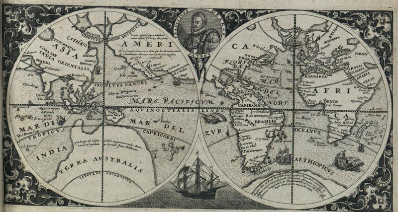
A map of Drake’s circumnavigation from the title page to Part VIII of De Bry’s Grands Voyages (1599), courtesy of the Library of Congress
There is no shortage of maps depicting Drake and his trip around the world, but they tend to be scant on solid factual details. This is in part because such details were deliberately obscured by Elizabeth, who commandeered all firsthand documentation of the voyage; most of these materials were destroyed or lost. This strategy was effective in keeping the Spanish in the dark, but it has also kept cartographers and historians in ignorance for centuries. In a 1580 letter from Gerard Mercator to Abraham Ortelius, Mercator grumbled, “I am persuaded that there can be no reason for so carefully concealing the course followed during this voyage, nor for putting out differing accounts of the route taken and the areas visited, other than that they must have found very wealthy regions never yet discovered by Europeans.” (He goes on to say that he believes the treasure from the voyage came from these newly discovered regions, not plunder, and then wisely pokes holes in the theory that Drake sought the Northwest Passage.)
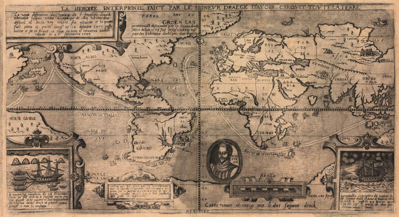
Nicola van Sype’s "La Herdike Enterprinse Faict Par le Signeur Draeck…" (circa 1583), the first printed map of Drake’s circumnavigation, courtesy of the Library of Congress.
The earliest printed map of the voyage is believed to be Nicola van Sype’s "La Herdike Enterprinse Faict Par le Signeur Draeck d’Avoir Cirquit Toute la Terre" (circa 1583). It was likely derived from the now-lost map that Drake offered to Elizabeth upon his return to England. The map shows Drake’s course, a portrait of the explorer at age 42, and vignettes of his encounter with Sultan Babullah and of one of his ships dashed on the rocks by Celebes. The location of Nova Albion on the map is vague, with the notation of its discovery oddly appearing all the way in Greenland. There are only a few known copies of this map; it is undoubtedly a rare and important map that presents a heroic view of Drake and his achievements. But as a cartographic source for future maps of the circumnavigation, it is hardly reliable.
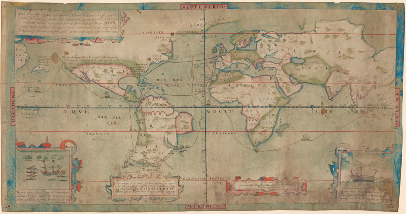
The so-called Drake-Mellon map (circa 1587), from the collection of Paul Mellon, is another contemporary copy of Drake’s map that also depicts his 1585-86 trip to the West Indies. (Courtesy of the Yale Center for British Art)
Over the centuries, countless maps followed in the wake of the Van Sype map, tracing the general trajectory of the Golden Hind around the world. Drake’s portrait is a common decorative feature on maps, especially those highlighting the great explorers. His conjectural island discoveries in southern South America continued to appear on maps into the late 18th century, and the New Albion nomenclature did not disappear from maps of America until the westward expansion of the mid-19th century. And of course, his name lives on in our contemporary maps, with the Drake Passage, Drakes Bay, and various other locations. Does it matter that Drake never sailed his own passage, or that the bay that bears his name may not be where he actually landed? There was never need for accuracy in the official story of Drake’s circumnavigation of the world. With Drake, England’s great pirate circumnavigator, the legend is the point.
REFERENCES
Kelsey, Harry, Sir Francis Drake: The Queen’s Pirate, Yale University Press, New Haven and London, 1998.
Kraus, Hans P., Sir Francis Drake: A Pictorial Biography, Library of Congress. https://www.loc.gov/collections/sir-francis-drake/articles-and-essays/drake-biography/
Layland, Michael F., “Dudley’s Last Secret,” Mercator’s World, Volume 5, Number 6, November/December 2000.
Shirley, Rodney, The Mapping of the World – Early Printed World Maps 1472-1700, The Holland Press Limited, London, 1987.
Wilson, Derek, The Circumnavigators, M. Evans & Company, New York, 1989.