Map Manipulations: A Brief Perspective on Gerrymandering
Map Manipulations: A Brief Perspective on Gerrymanderingby Jon Dotson
Throughout modern history, maps have been used as a tool of visual influence. Whether displayed as a statement of fact or pure aspiration, maps were often drawn up for political reasons to convey ownership and authority. While the large boundary disputes of the past 400 years have been resolved in the United States, the mapping of legislative districts continues to be highly contentious and fluid.
Pre-Dating Gerrymandering: Political Imbalances in Colonial America The practice of manipulating boundaries for political gains began back in colonial times. Early political units were usually composed of plantations, towns, and mostly counties. Rapid settlement along the east coast required new counties to be established, and existing counties often needed to be divided further into smaller administrative units.
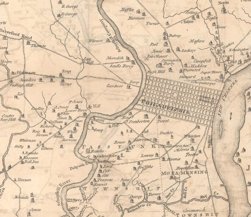
Accelerated growth led to the first true case of gerrymandering in 1701 in the colony of Pennsylvania. According to its original Charter of Privileges authorized by William Penn, each county was granted four representatives and the city of Philadelphia was granted two. This approach was originally met with satisfaction by all parties involved as it acknowledged the needs of both rural and urban citizens. Over the next fifty years, however, the city of Philadelphia would experience large population gains and at the same time rise in national prominence. Yet the neighboring Bucks, Chester, and Philadelphia counties, jealous of the elevated stature of the city, were unwilling to change the original charter and reapportion representation. According to Griffith, "So pronounced was this political inequality that the city joined with the western counties, as they were erected, in the demand for adequate political recognition" (Griffith, pp. 27-28). Finally in 1771 and again in 1776, the city was given additional representation, and after three-quarters of a century, the eastern counties of Pennsylvania lost their power.
A Map of Philadelphia and Parts Adjacent, by Scull & Heap, published 1753. Image Courtesy of Old World Auctions
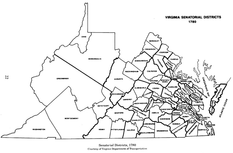
Virginia also experienced growing pains. In 1776, just prior to declaring independence from Great Britain, the state was divided into two distinct groups. To the east of Richmond was the rich, slave-holding population that thrived on the tobacco trade. To the west of the Piedmont region was a huge frontier that consisted of non-slave holding whites. After the state's first constitution was created, Virginia was divided into 24 senatorial districts. While the eastern group only numbered 19,000 voting men compared with 30,000 for the western group, the eastern group received 12 of the 24 state senators. In percentage terms, eastern Virginia included 38.8% of the population but 50% of the seats. The region west of the Blue Ridge mountains (which also included Kentucky), received only 4 senators (Ambler, p. 30). This was possible because districts uniformly consisted of 3 counties regardless of size or population, so the smaller counties in the east achieved greater representation. This concept is represented by the following district map that was issued a few years later.
Virginia Senatorial Districts 1780. Image courtesy of the Virginia Elections and State Elected Officials Database Project, 1776-2008 (http://vavh.electionstats.com/).
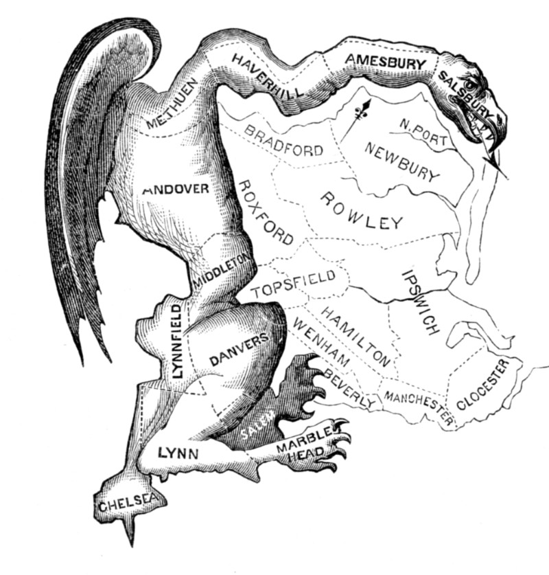
Origins of "Gerrymandering" With the rise of a new nation, competition emerged between the two major political parties. The term "Gerrymandering" was coined in 1812, when Elbridge Gerry was governor of Massachusetts. His party, the Jeffersonian Democratic-Republicans, was competing against a rising Federalist movement that had gained momentum due to the conflict with Britain. In an attempt to protect the party's influence in the state senate, Gerry authorized the maps to be redrawn based upon the 1810 census. Particularly unusual was the new map of Essex County that revealed a sinuous Republican district running from Salisbury west to Methuen and Andover, and south to Chelsea and Lynn. A Federalist-leaning editor in Boston was reviewing the map with colleagues when one remarked that it looked like a salamander. The editor, using a portmanteau, exclaimed "Salamander! Call it a Gerrymander!" (Monmonier, pp. 36-37). The map was first published in the March 6th, 1812 edition of the Boston Weekly Messenger, and Elkanah Tisdale added more graphic imagery to the map below for the March 26th, 1812 edition of the Boston Gazette.
The Original Gerrymander. Published in the Boston Gazette. Image courtesy of Wikimedia Commons.
Modern-Day Gerrymandering Fast forward to today's world and we see much of the same activity, but the practice is increasingly widespread. Every decade congressional maps are allowed to be redrawn after the release of new census data. According to the Extreme Maps report released earlier this year by the Brennan Center (NYU), "redistricting allows districts to be rebalanced, ensuring in theory that all districts are both equally populated and representative. But redistricting also provides an enormous opportunity for politicians: the chance to redraw a district map means the opportunity to gerrymander and to manipulate a map to create a more favorable set of districts for themselves and for their party" (Li/Royden, p. 1). This means that whichever party is in control at a state level is likely to draw maps that favor the incumbent.
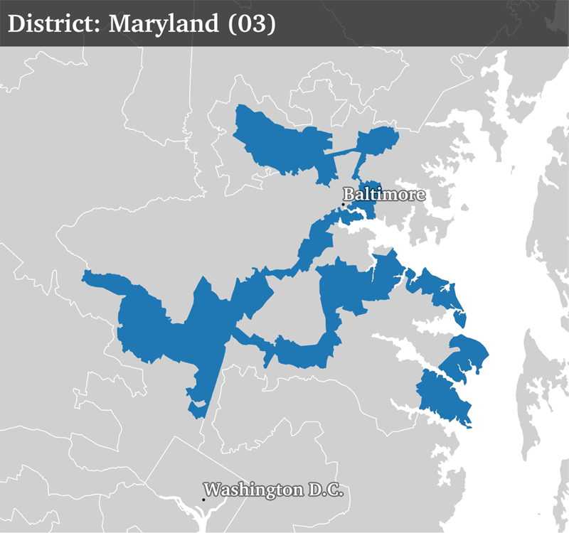
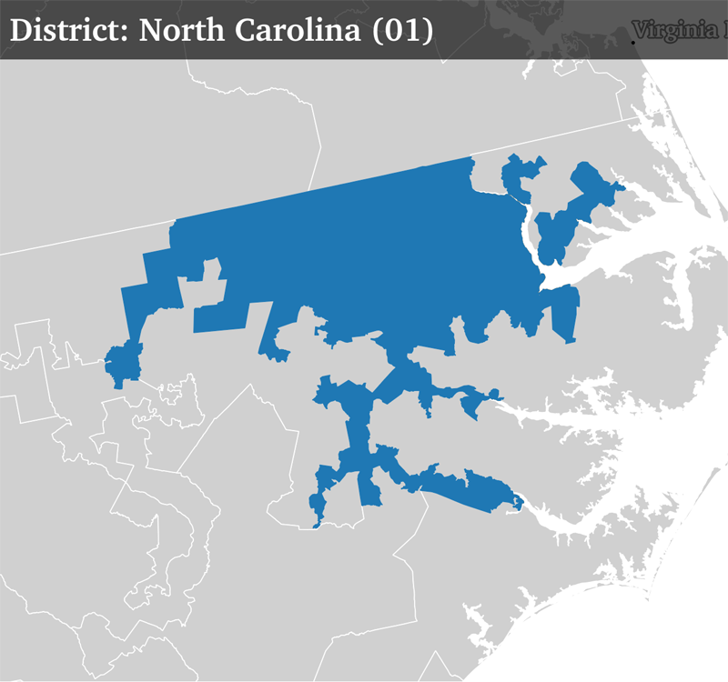
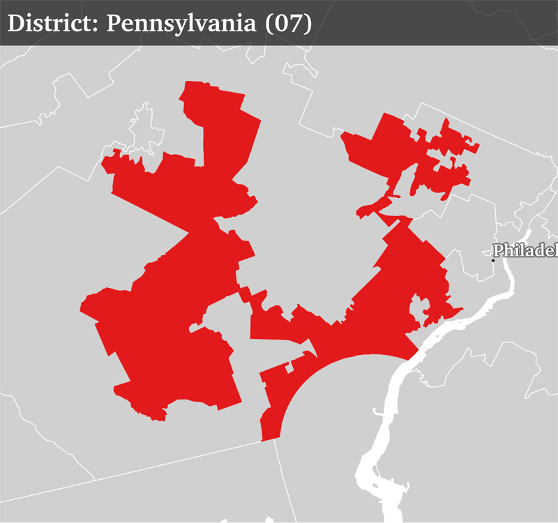
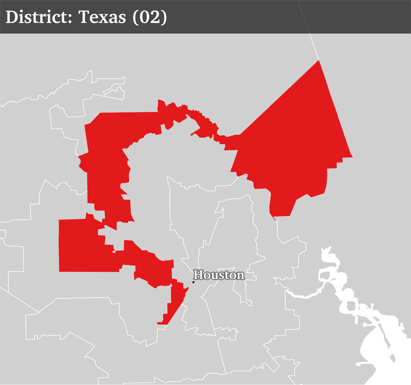
The manipulation of district maps has been well documented against both Democratic and Republican parties. Below is a sampling of maps from the current, 114th Congress with some questionable shapes.
A Sample of Unusual Congressional District Maps. Courtesy of Alasdair Rae, University of Sheffield, UK
It is important to point out that often times the strangest looking maps are a result of the controlling party pushing the minority vote into a single district in order to reduce the minority's voting power in the other, more numerous districts. This strategy is called "packing" (concentrating into one district) and "cracking" (diluting the other districts). This strategy is exhibited in three of the four images above.
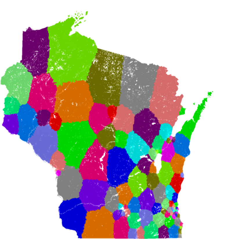
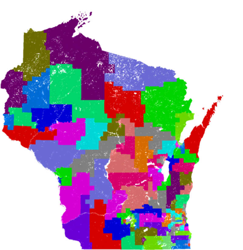
Possible Remedies James Madison once said "the majority will generally violate justice when they have an interest in doing so." Given human nature's penchant for self-interest, a possible solution would be to let computers determine congressional districts. One such computer algorithm, run by software engineer Brian Olson, creates districts that are as compact as possible with equal population sizes. Olson's work was lauded by the Washington Post's Christopher Ingraham who wrote that "this computer programmer solved gerrymandering in his spare time.” Olson's body of work includes remapping all of the congressional districts based upon the 2010 census. The visual differences to the existing maps are eye-opening. Take Wisconsin for example:
Wisconsin State Assembly - Computer Generated Map (left) vs. Existing Map (right). Images courtesy of Brian Olson (http://www.bdistricting.com).
Some political scientists argue that compactness (which most computer algorithms use to establish lines) ignores the concept of "communities of interest." These communities share something in common that makes them unique - whether it be class, culture, geography, etc that would be impossible to replicate on a computer. A simple example of this would be the district containing Virginia's Shenandoah Valley. While it is a rather long, narrow district, it does represent a distinct cultural and geographical community that would certainly be broken up in any computer model:
Virginia Congressional Districts - Computer Generated Map (top) vs. Existing Map (bottom). Images courtesy of Brian Olson (http://www.bdistricting.com).
While computer algorithms can certainly help in creating options, critics argue human input is required to balance the variety of factors at play.
Fortunately, the United States Supreme Court recently agreed to hear a case which will hopefully settle the issue of an "unconstitutional partisan gerrymander." The anticipated case, which will be heard this fall, stems from a lower court ruling that the 2011 Wisconsin state assembly plan violated the first and fourteenth amendments. In 2012, Republicans won 60.6% of seats despite winning only 48.6% of the vote. The court concluded that the distributions of Democrat and Republican voters throughout the state are not responsible for the Republican Party’s electoral advantage (Brennan Center). According to Wendy Wesier, director of the non-partisan Brennan Center’s Democracy Program (NYU), "This is a historic opportunity to address one of the biggest problems facing our electoral system. Gerrymandering has become so aggressive, extreme, and effective that there is an urgent need for the Supreme Court to finally step in and set boundaries.”
Until formal and specific regulations have been established, gerrymandering will continue to be a national headline. Increased partisanship coupled with recent advances in technology means these cartographic manipulations will become widespread. John Adams in his Thoughts on Government (1776) put it best: "The principal difficulty lies, and the greatest care should be employed in constituting this representative assembly. It should be in miniature an exact portrait of the people at large. It should think, feel, reason and act like them. That it may be the interest of the assembly to do strict justice at all times, it should be an equal representation, or, in other words, equal interests among the people should have equal interests in it. Great care should be taken to effect this, and to prevent unfair, partial and corrupt elections."
References:
Ambler, Charles Henry, Sectionalism in Virginia, 1776-1861, Chicago, 1910.
Brennan Center, " SCOTUS Set To Hear First Partisan Gerrymandering Case in a Decade", Published on their website < http://www.brennancenter.org/press-release/scotus-set-hear-first-partisan-gerrymandering-case-decade>.
Griffith, Elmer Cummings, The Rise and Development of the Gerrymander, Scott, Foresman and Company, Chicago, 1907.
Ingraham, Christopher, "This computer programmer solved gerrymandering in his spare time", <https://www.washingtonpost.com/news/wonk/wp/2014/06/03/this-computer-programmer-solved-gerrymandering-in-his-spare-time>.
Li, Michael and Royden, Laura, Extreme Maps, The Brennan Center for Justice at NYU School of Law, 2017.
Monmonier, Mark, "Hook, Line, and Gerrymander", Mercator's World, Number 4 (Volume 5), Eugene, Oregon, 2000.