The depiction of Korea on Western maps has an interesting and mysterious history. Its depiction as an island on maps in the sixteenth and seventeenth centuries stemmed from a lack of knowledge, as one might assume, but even well after the myth was dispelled, the island of Korea continued to appear on maps. Why was there so little knowledge about Korea among Europeans? While a number of books on explorations in the Far East were published at the time, including specific works on its neighbors China and Japan, why was so little written about Korea? Where did Europeans gather information about Korea and how did the concept of Korea as an island begin?
The first mention of Korea to a European audience was in Marco Polo's Travels..., circa 1300, in which the term "Cauli" (or Kauli) was used to describe what was believed to be a portion of Korea. However Marco Polo's reference to Korea was both minimal and vague, and did not spark European interest in the country. It would take nearly 300 years for more detailed and reliable information on Korea to reach Europe, and one must look back to the beginning of the age of exploration to understand why. As a result of the Treaty of Tordesillas in 1494, Spain and Portugal divided the world in half, giving Portugal exploration rights in the Far East while Spain retained rights to the majority of the Americas. Soon thereafter the Portuguese King sent Vasco da Gama to find a sea route to Asia by sailing around the continent of Africa in the hopes of finding a swifter passage to the lucrative spice trade in Asia. Da Gama reached Goa, India in May 1498, established a base there, and thereby led the way for other Portuguese explorers to head further east. The Portuguese reached Malacca, Malaysia in 1511; Ternate, Indonesia in 1512; Guangzhou, China in 1513; and Japan in 1542.
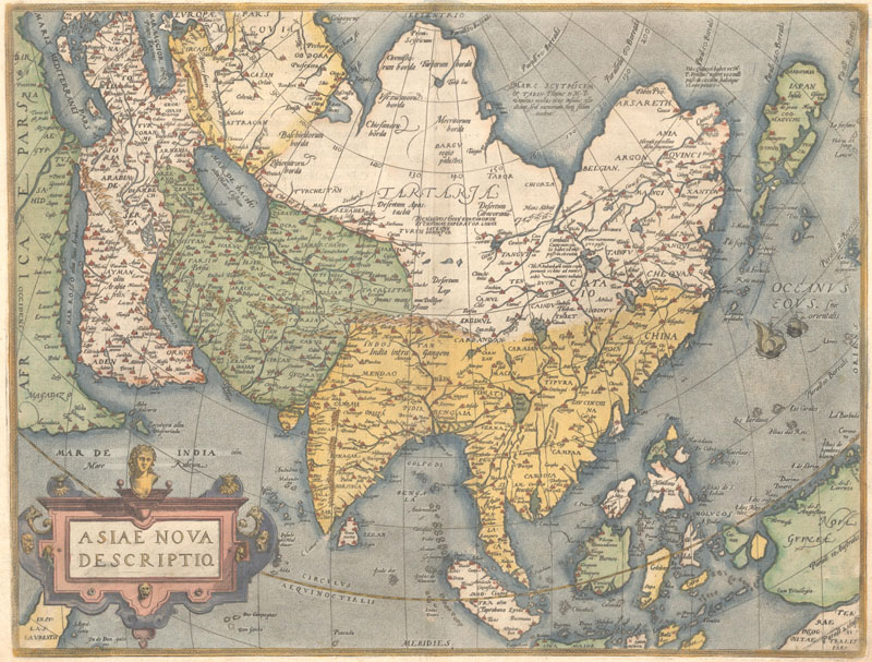
Abraham Ortelius, Asiae Nova Descriptio, 1570.
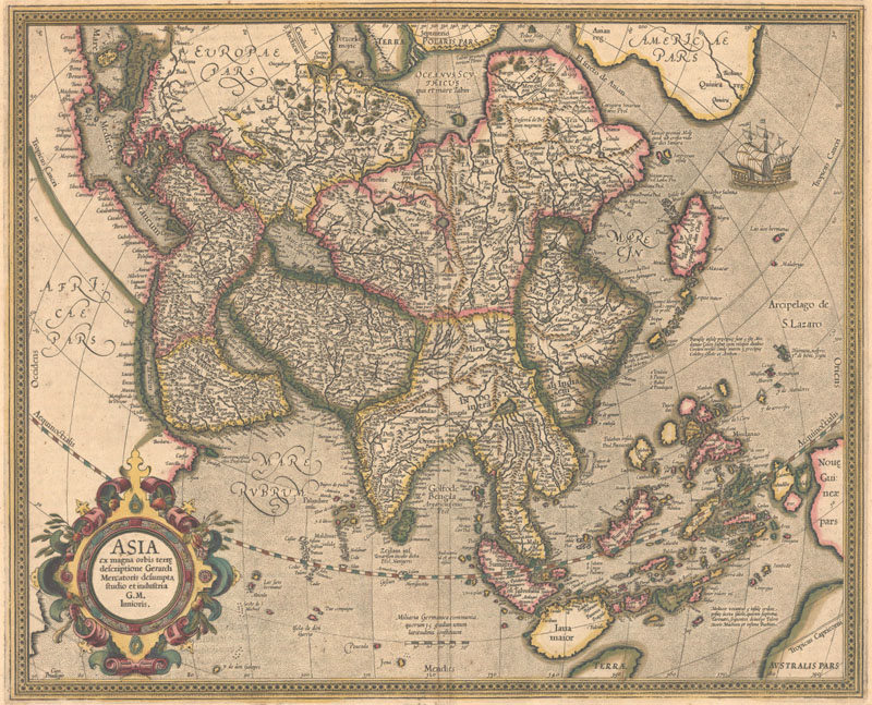
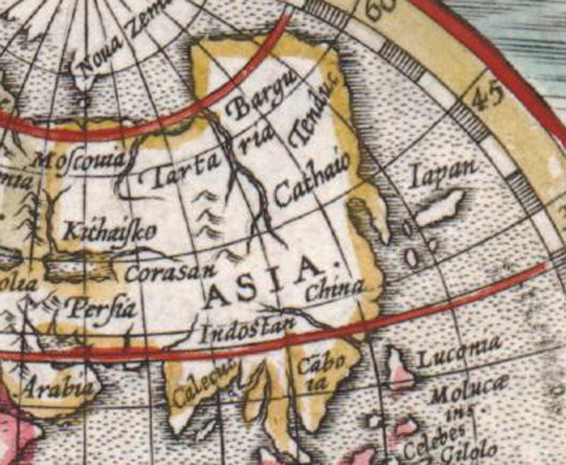
Gerard Mercator, Asia ex Magna Orbis Terre Descriptione, 1587.
Gaining access to a precious supply of goods was certainly the most important reason for Portuguese expansion into the Far East, but not the only reason. Portugal also desired to monopolize the Catholic mission in Asia, and numerous Jesuits were sent to China, Japan and elsewhere in Asia to introduce Christianity to the pagans. It was largely through these Jesuit missions that information was relayed back to Europe about the geography, culture, politics, and history of various Asian countries. The Jesuits would write letters to Rome on their experiences, and eventually these letters were published in books called "Annual Letters" that were made available within the church, and later to the public with the intention of promoting support for missionary work in Asia. There was a great deal of information in the letters about China, Japan, and southeast Asia, where Jesuit missions were located; however no Jesuit missionaries were located in Korea, and thus information on Korea came from second-hand sources. The Jesuits learned about Korea primarily from Chinese and Japanese sources, whose accounts were often biased. The Portuguese developed a general impression that the Koreans were inhospitable and not interested in building trade relations with Portugal. One corroborating account came from an Italian priest, Father Antonio Prenestino, who was aboard a Portuguese ship sailing from Macao to Japan in July 1578. The ship was blown off course by a storm and drifted close to the Korean coast. Although the ship never landed on Korean shores and was able to continue its journey to Japan, Prenestino wrote in a letter to Lisbon: "Korea, a barbaric and inhospitable people, desires to have dealings with no other people. And they say that in the past a Portuguese junk wished to stop here, but these wicked people took their boat and all who were in it, and they were lucky to get away without being burned alive."
Most of the Jesuit letters in the late 16th century that mentioned Korea were written by another Jesuit missionary in Japan, Luis Frois. In his letters, he discusses the lead up to the Japanese invasion of Korea as early as 1582, and later chronicles the war itself. Frois wrote that a Japanese Regent was "to set forth his armies, and to passe to the land of Coray, which the Portugales call Coria, being divided from Japan with an arme of the sea." Frois also explained that although Korea was previously thought to be an island, it was indeed a peninsula lying to the west of Japan and bordering China. Frois based all of his information on Korea from Japanese sources, and never actually set foot himself in Korea. Other letters, also based exclusively on Japanese sources, came from Father Gaper Vilela, who wrote in 1571: "According to my information, this kingdom is said to extend as far as some very high mountains, and beyond them live people of white race, with whom however they have no dealings on account of the many dangerous wild animals that live in the mountains. It may be conjectured that these lands beyond could be Germany. The Mongols in question are said to be a friendly race." Although wildly inaccurate in his belief in Korea's proximity to Germany, Vilela alludes to the fact that Korea is a peninsula, with a direct overland route to Europe. Vilela had attempted to enter Korea, but was unable to do so due to a civil war in Japan. When Vilela requested permission to establish a mission in Korea, his plan was rejected by the Society of Jesus, which deemed the mission in Japan as a priority, and did not want to divert missionaries to Korea.
The first record of a Westerner visiting Korea occurred as a result of the Japanese invasion of Korea in 1592. Father Gregorio de Cespedes was a Jesuit missionary in Japan and was brought to Korea in 1593 to help tend to the Japanese troops. He spent about a year in Korea, and did not leave with a favorable impression of the country. He wrote two letters while in Korea, but focused his commentary on the harsh winter and the battles, ignoring the culture, politics, or geography of the country. By the end of the sixteenth century, very little information on Korea had reached Europe, with the majority of it based on biased, second-hand sources. Korea was predominantly deemed unwelcoming from the viewpoint of both Jesuits and merchants. Furthermore, merchants did not believe that Korea offered valuable resources for which the Europeans would want to trade, particularly in comparison with its more friendly neighbors. Korea remained a mysterious country, largely ignored by the Portuguese.
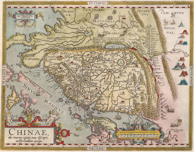
Abraham Ortelius, Chinae, olim Sinarum Regionis, Nova Descriptio, 1584.
Of course the Portuguese were not the only Westerners with interest in the Far East. Although the Treaty of Tordesillas was observed by the Spanish, other European powers, particularly Protestant ones, did not comply with its directives and were eager to break Portugal's monopoly on the spice trade. The Portuguese had cunningly maintained secrecy around their explorations, sea charts, and knowledge of the Far East, making it difficult for others to follow their path. However, in 1595-96, Jan Huygen van Linschoten published the Itinerario, a Dutch-language travel guide that included detailed navigational instructions and maps of Asia, as well as information on the weaknesses of the Portuguese monopoly in the region. Linschoten, a Dutchman, had lived in India for five years as the assistant to the Portuguese Archbishop of Goa, and had been given access to Spanish and Portuguese charts and sources. The publication of the Itinerario, which also appeared in German and English in 1598, in Latin in 1599, and in French in 1610, spurred the Dutch and English to begin explorations in the Far East. As his work was based primarily on Portuguese sources, Linschoten made only brief mentions of Korea, and many of his descriptions were inaccurate: "A little above Japan, on 34 and 35 degrees, not far from the coast of China, is another big island, called Insula de Core, from which until now, there is no certainty concerning size, people, nor what trade there is."
Around the same time as the Itinerario, an Englishman by the name of Richard Hakluyt published the second edition of his Principal Navigations, a series of maritime accounts that included information on the geography and culture of Korea. Hakluyt had collected Spanish and Portuguese maritime materials as well as Jesuit "Annual Letters." He derived most of his information on Korea from the Jesuit letters, including those of Frois describing Korea as a peninsula. By 1600, there was basic information about Korea available in multiple European languages, with most accounts corroborating the fact that Korea was a peninsula.
Petrus Plancius, Orbis Terrarum Typus de Integro Multis in Locis Emendatus, 1594
Jan Baptista Vrients, [Untitled - World], 1601.
Unfortunately, geographic and cartographic knowledge about Korea did not reach the hands of the many cartographers of the sixteenth and early seventeenth centuries. Although Korea appeared on several manuscript maps as early as the 1560's, these were kept secret by the Portuguese and did not have much influence on the cartography of Korea by most Europeans, and are therefore outside of the scope of this article. Engraved maps of the world and of Asia in the latter half of the sixteenth century omitted Korea completely, as information about the country had not yet been disseminated within Europe. Munster's, Ortelius', and Mercator's maps of the world and Asia portray this lack of knowledge of the Far East, with no hint of Korea. Possibly the earliest engraved map to show Korea is Petrus Plancius' map of the world, Orbis Terrarum Typus de Integro Multis in Locis Emendatus, first issued in 1594. Korea is correctly depicted as a peninsula, although in an elongated form, and is labeled simply "Corea." Others apparently follow Plancius' model, including Edward Wright, who created a world map for the second edition of Hakluyt's Principal Navigations in 1599, and Jan Baptista Vrients, who included a miniature double-hemisphere world map in his edition of Ortelius' Epitome in 1601.
However at the same time that maps were published depicting Korea as a peninsula, others began to show the country as an island. Linschoten included a map of east and southeast Asia in his Itinerario of 1595 that offered one of the first island portrayals of Korea. Designed by Arnold Floris van Langren, the map depicts a large, almost circular island named "Ihla de Corea" near the coast of China. Although many later maps would show Korea in an island form, none appear to have copied Langren's round shape.
Jan Huygen van Linschoten, Exacta & Accurata Delineatio cum Orarum Maritimarum tum Etiam Locorum Terrestrium quae in Regionibus China, 1595.
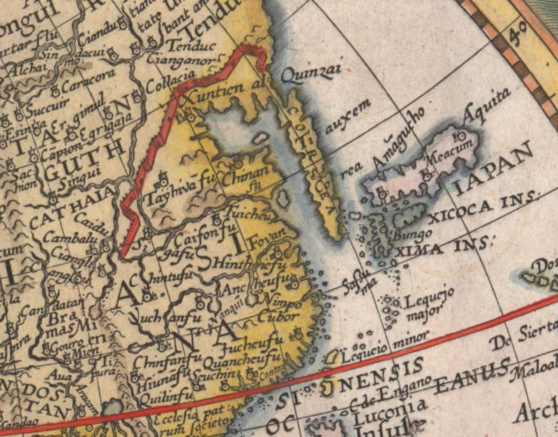
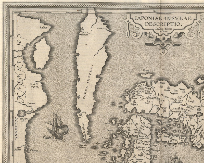
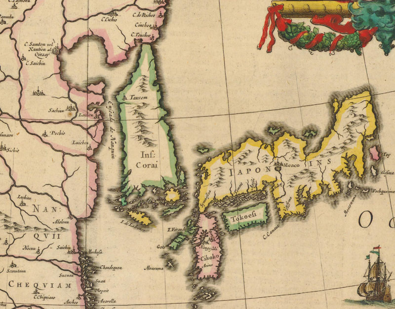
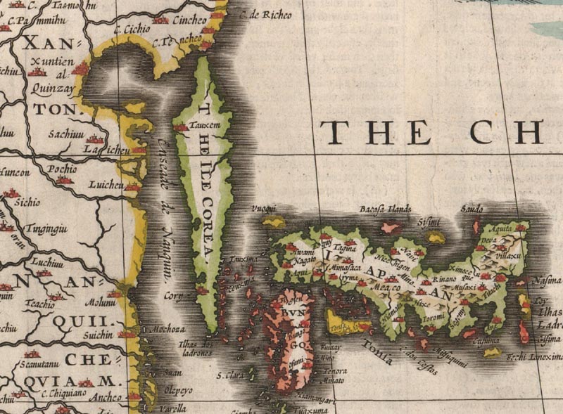
Korea also makes its first appearance in Ortelius' Theatrum Orbis Terrarum in 1595 on a newly engraved map of Japan, based on the work of Portuguese Jesuit Luis Teixeira. Ortelius' Iaponiae Insulae Descriptio depicts Korea as an elongated island, wide in the center and narrow at the northern and southern tips. Likely due to the popularity and wide distribution of Ortelius' Theatrum, this "Teixeira" island form became the predominant depiction of Korea for many years. After acquiring Gerard Mercator's copperplates, Jodocus Hondius had new maps of Asia and China engraved for his 1606 edition of the Atlas, both of which depicted the Teixeira island form of Korea.
Abraham Ortelius, Iaponiae Insulae Descriptio, 1595.
Jodocus Hondius, China, 1606.
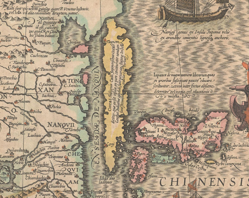
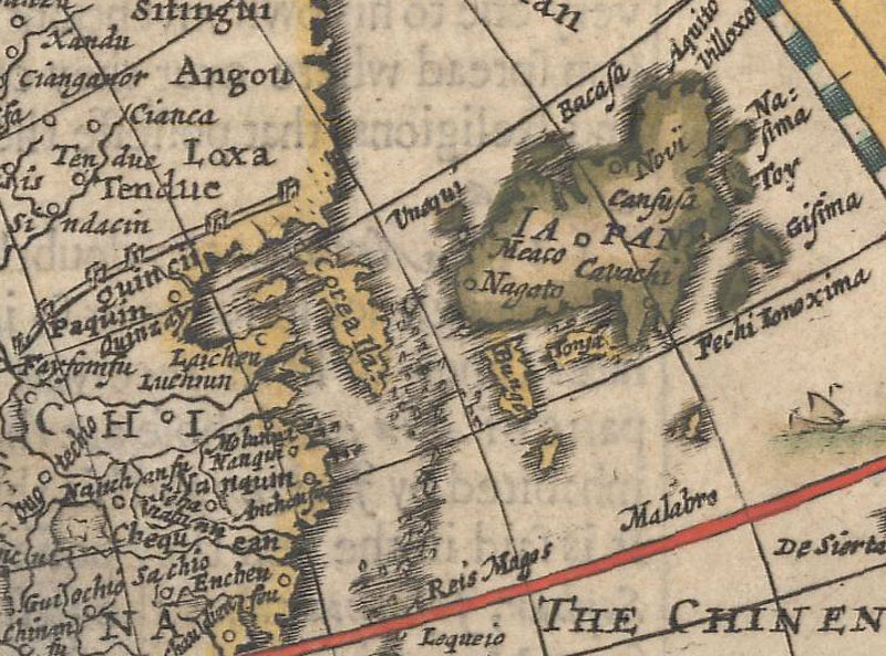
Willem Blaeu also adopted the Teixeira form in his maps of the world and Asia, first published in his Appendix in 1630, however when he added a map of China in 1634, Korea took on a new shape. In China Veteribus Sinarum Regio, the southern portion of Korea is rectangular, ending in a point in the northeast.
Willem Blaeu, China Veteribus Sinarum Regio, 1634.
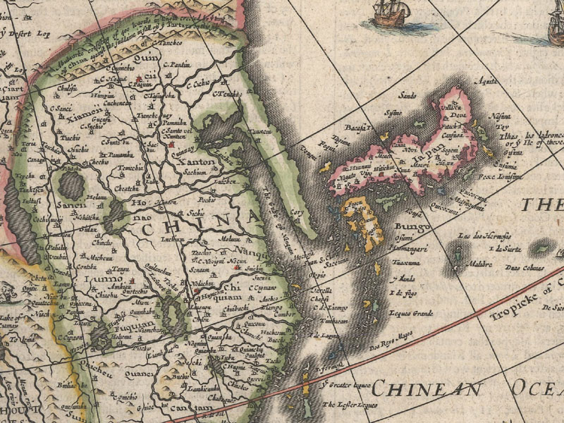
In 1626, John Speed's A Prospect of the Most Famous Parts of the World was published with conflicting depictions of Korea. This was not uncommon as maps for the same atlas were often engraved in different years, by different engravers, and based on the work of different cartographers. On Speed's map of China, Korea is presented as an elongated island in the Teixeira form. Speed's map of Asia, however, depicts Korea as an elongated peninsula, without a bulge in the center, and adjacent to Japan, which appears in the same form as on the map of China. In contrast, Speed's map of the world, based in part on William Grent's map, presents Korea as an island, although much less elongated in shape. Speed's only other map to depict Korea is his map of Tartary, which also shows Korea as an island, and although the island is partially obscured by the title cartouche, it does appear to be quite elongated. On his four maps that depict Korea, all published in the same atlas in the same year, Speed includes three distinct versions of Korea. It was left up to the reader to decide which version he or she preferred.
Maps in 1626 edition of John Speed's A Prospect of the Most Famous Parts of the World: Top: A New and Accurat Map of the World Bottom left: Asia with the Islands Idioyning
Bottom right: The Kingdome of China Newly Augmented
It is interesting to note that the cartographic depiction of Korea did not progress in a linear fashion. The various forms of Korea -- whether as a peninsula, an island, or completely omitted -- appeared simultaneously throughout the late 16th and much of the 17th centuries. And although there were predominant shapes for the island form, these were also interspersed, driven by whose work was being copied rather than new geographic information that was being introduced. It is not known exactly how Korea was first mistakenly identified as an island, but one leading theory does provide insights. The Portuguese Jesuits typically had access to Chinese and Japanese-made maps, and occasionally to Korean-made maps that had been acquired by the Chinese or Japanese. In some of these maps, the two rivers (Yalu and Tumen) that serve as the border between China and Korea are so exaggerated that Korea could be mistaken for an island. With the language barrier and an absence of Western surveys of the Korean coastline, it is conceivable that the Portuguese could misinterpret these maps made by Far Easterners. Another compelling clue is the fact that many of the maps that depict Korea in an insular form show it separated from mainland China in the north by a very narrow strait.
Finally in the 1650s new cartographic information became available to dispel the myth of Korea as an island. The first came from Jesuit Father Martino Martini, who traveled through China between 1642 and 1651. Martini published Bellum Tartaricum in 1654, which included a map of China and Korea, and collaborated with Joan Blaeu on Novus Atlas Sinensis, part of volume 10 of the Atlas Maior and first published in 1655. Due to Martini's access to Chinese maps during his travels, he succeeded in producing very accurate maps of Japan, China, and their provinces, as well as confirming that Korea was a peninsula. The second important account came from Hendrick Hamel, a Dutchman who shipwrecked on Jeju Island in South Korea in 1653 while on board a ship owned by the Dutch East India Company ship, which was headed to Japan. Hamel and dozens of other crewmembers survived the crash and were held captive by Koreans. Although most of the crewmembers perished, Hamel survived 13 years in Korea until he escaped to Nagasaki in 1666 with the remaining 7 crewmembers. Hamel wrote about his experience in Korea in Journal and a Description of the Kingdom of Korea, which was first published in 1668. Hamel's account was the most comprehensive, first-hand information on Korea that had ever reached Europe. Although his journal did not contain maps, he included geographical information in his writing that influenced cartographers for many decades.
Jan Jansson & Jan van Loon, Imperii Sinarum Nova Descriptio, 1656. (Copied from Blaeu's map of the same title published in 1654.)
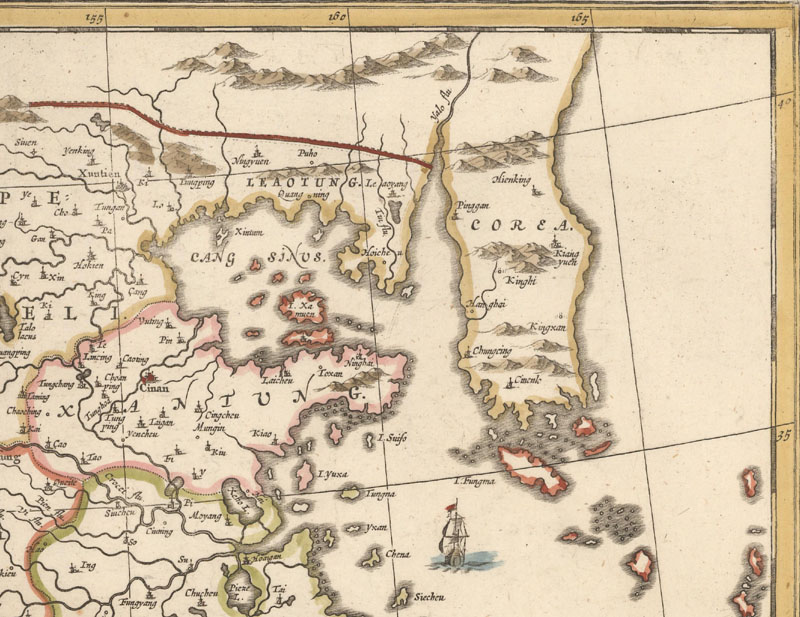
The results of these new accounts made a big impact on cartography. The shape of the peninsula was still far from accurate and there was an absence of geographic information regarding the interior of Korea, yet the "island" myth was slowly dispelled. Of course even a few maps published in the early 18th century still depicted Korea as an island, due to lazy (and often unscrupulous) copying of earlier maps. Further updates to the mapping of Korea did not occur until Jean Baptiste Bourguignon d'Anville's map of Korea was published in 1735, finally showing a correct outline for the country and more detail in the interior. By this time, the idea of an insular Korea was a distant memory. Yet ironically, the term "insular" - albeit the non-geographical definition - is commonly associated with North Korea to this day.
References:
Baynton-Williams, Ashley, "Korea as an Island," MapForum, Issue 8, London, 2005.
Kazutaka, Unno, "European Cartography of Korea in the Sixteenth and Seventeenth Centuries," Journal of the Korean History of Science Society, Vol. 9, No. 1, Seoul, Korea, 1987.
Savenije, Henny, "Korea in Western Cartography," Korean Culture Vol. 21 No. 1, Los Angeles, CA, 2000.
Shirley, Rodney W., The Mapping of the World, The Holland Press Limited, Otley, England, 1987.
Short, John Rennie, Korea: A Cartographic History, Chicago, IL, 2012.
Sung-hwa, Cheong & Lee Kihan, "A Study of 16th-Century Western Books on Korea: The Birth of an Image," Korean Historical Review, Seoul, Korea, 1999.
Yeo, Julie, Mapping the Continent of Asia, Antiques of the Orient Pte. Ltd., Singapore, 1994.