A Cartographic Paradise: The MacLean Collectionby Eliane Dotson
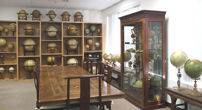
Walking into the large, industrial building in the suburbs of Chicago, I wasn't sure what to expect. What I discovered inside was more breathtaking than I could have imagined. To my right was a glass-walled room filled with globes of all sizes and ages, displayed from floor to ceiling. In front of me was the main room, with an island stationed in the center, comprised of rows of map drawers with a butcher-block countertop, covered in rare maps. The walls around me boasted massive wall maps. Each room surrounding the main room was brimming with pocket maps, atlases, posters, and more. This was a map lover's dream - a cartographic paradise.
Globe Room
It was in October 2013 that I had the pleasure of visiting the MacLean Collection as part of a field trip for dealers exhibiting at the first Chicago International Map Fair. We were invited by Barry MacLean and Tom Hall, the curator for the collection. We spent the morning perusing through sheet maps, atlases, and racks and racks of wall maps. Interspersed among the usual suspects were some unique items, including a 20th century work of art in the form of a globe and even a hand-knotted rug featuring a map. It was an inspiring morning that left an impression on all of us.
The MacLean Collection began in the early 1960s, when Barry MacLean started collecting maps. He initially focused on foundation maps for the Great Lakes region. He soon realized the importance of maps in understanding the history of the United States and expanded the scope of his collection to include maps that illustrated regional surveys. The westward expansion of the growing United States was documented in pocket maps, wall maps, and atlases, all of which became integral components of the collection. As the collection continued to grow, the focus of the collection continued to widen. MacLean realized that he had amassed an impressive library of cartographic material, and that it was time to put the library in order. In the late 1990s, MacLean approached a local bookbinder with whom he had done business, and asked if he knew anyone who could help inventory and catalog his collection. Tom Hall, an employee of the bookbinder at the time, proved to be the right person for the job.
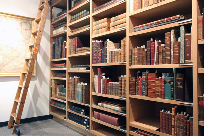
Rare Atlas Room
Over the years Hall has been the primary curator and librarian of the MacLean Collection, helping to organize and catalog the collection, as well as assist in acquiring new material. The collection now boasts over 35,000 maps, globes and books ranging from the 15th century to the present. The types of media contained in the collection is quite broad, including globes, wall maps, sheet maps, pocket maps, case maps, atlases, manuscript maps, relief maps, pictorial maps, Portolan charts, posters, cartographic games and puzzles. Although maps of the Great Lakes, US states and counties, and 19th century American maps continue to be key strengths of the MacLean Collection, other concentrations include British county maps, wall maps, and world maps. As the material is cataloged, new areas of future growth potential are discovered, spurring additional acquisitions in those areas. The collection is never static, with several hundred items added each year to fill gaps in the collection.
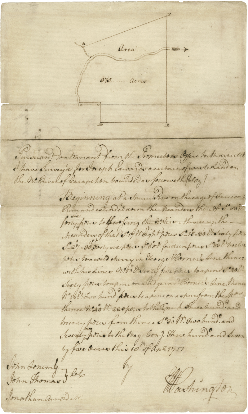
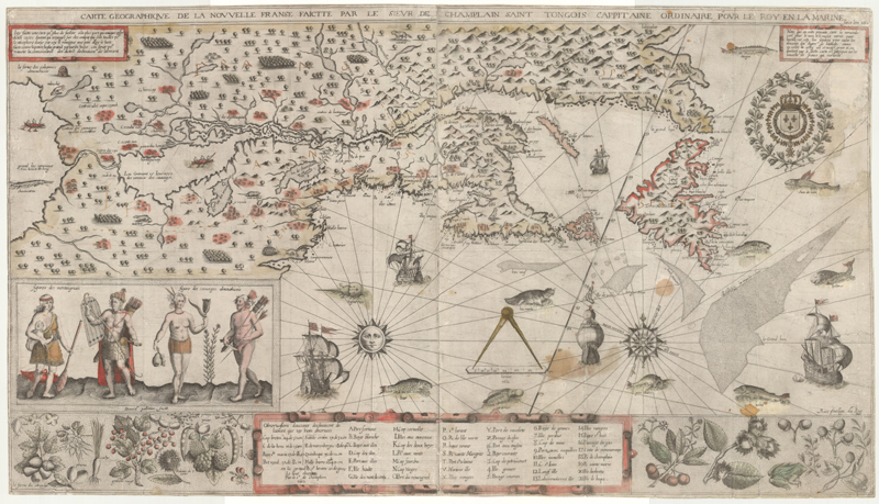
One highlight of the collection is a manuscript land survey of the Capacon River Valley in Virginia produced by George Washington on April 18, 1751. The survey was created on behalf of Joseph Edwards, who was appointed Justice of the Peace that same year. The survey detailed an area that later became known by "Mercer's Massacre" or the "Battle of the Great Cacapon River." Another important piece in the collection is Samuel de Champlain's map, "Carte Geographique de la Nouvelle Franse," based on sketches Champlain made during his voyage of 1603-07. The map illustrated the interior of North America for the first time to a European audience, thereby encouraging exploration into the Midwest and beyond.
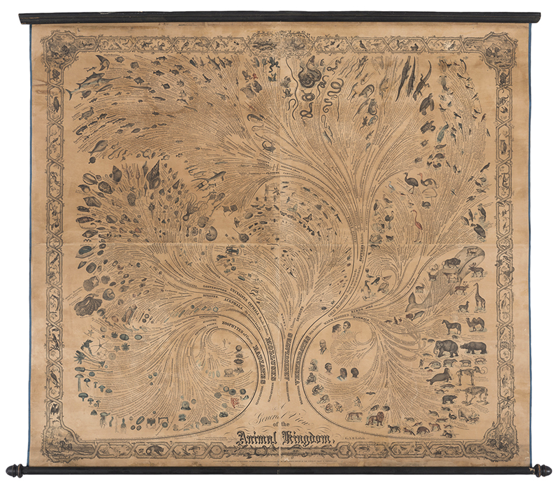
The collection also includes fascinating and rare thematic maps, including a zoological wall-chart by Anna Maria Redfield entitled "A General View of the Animal Kingdom," published in 1857, which represents the earliest known tree of bio-diversity based on a systematic classification structure. These three examples showcase the breadth and uniqueness of the collection, with thousands more cartographic gems to be uncovered.
Anna Maria Redfield, A General View of the Animal Kingdom, 1857
Beyond being a "cartographic paradise," the goal of the MacLean Collection is to become a research library for scholars of history and cartography. Although the collection has remained largely unknown to the map world until recently, the intent is now to encourage researchers to use the collection to advance their work. Hall supervises a full-time staff of catalogers, conservators, and even an imaging specialist, who continue to develop the collection and make it more accessible to researchers. The only barrier to using the collection is that it is currently only viewable in person at the MacLean Library itself, and researchers must schedule an appointment to view the collection. However once you find yourself in the library, a treasure-trove of material awaits, with several key advantages over other map libraries. Researchers are free to browse through the drawers, shelves, and racks of material and pull items that are of specific interest. Of course security protocols and a robust security system are in place to ensure that visitors are properly monitored and the collection remains safe and secure. A small portion of the collection is tagged with QR codes (with plans to expand this system in the future), which can be scanned with a portable device to access the full catalog information for a particular item. And because the collection offers both breadth and depth of material, scholars can view and compare related items, such as multiple states and editions of a particular map or atlas. This can be particularly useful when researching a topic that spans material from various media or time periods.
Samuel de Champlain, Carte Geographique de la Nouvelle Franse, 1612
The MacLean Collection also offers fellowships for scholars and internships for students to support the study of history and cartography. Scholars can make proposals to the MacLean Collection with information on their topic and scope of research in order to be considered for a fellowship. A recent fellow, Susan Schulten, Professor and Department Chair of History at the University of Denver, used the library to study two topics: the education of geography in schools, and the evolution of postal mapping in the United States. Schulten explained one of the benefits of how the library is structured: "The wall maps are easily consulted on several racks in two areas. Because they are easily seen together, one can begin to raise and answer questions about publishing trends, the evolution of the genre from the eighteenth to the early twentieth centuries. Even being able to walk through a century of school atlases on the shelf is instructive, for it showcases the trajectory of size, scale, depth, cost, and the material dimension that is often lost when one consults these items individually." The culmination of these fellowships comes in the form of lectures and published articles and books. The first book released based on the MacLean Collection was Richard Pegg's "Cartographic Traditions in East Asian Maps," and there are more to come in the future. (Click here to view a summary of the book).
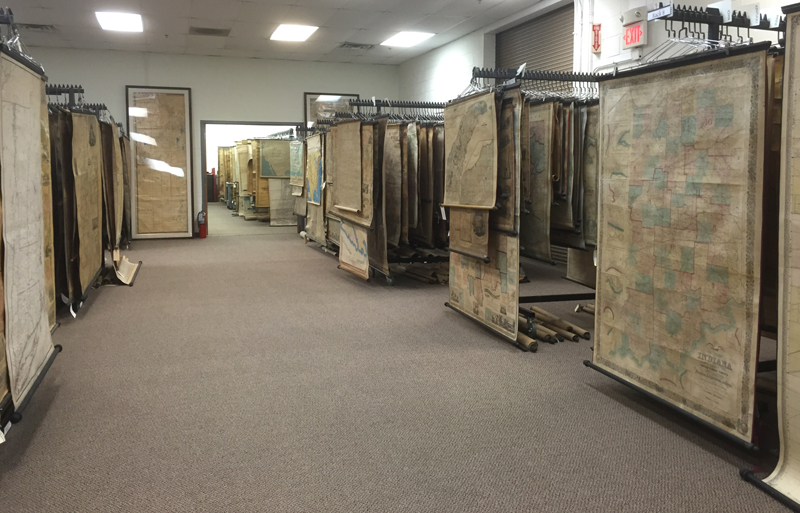
Wall Map Room
While researchers may come and go, the MacLean Collection is certainly here to stay. With its vast collection, there is material to fulfill any cartographic interest and many hidden gems to be discovered. There are maps that will awe you, globes that will make your head spin, and books that are truly page-turners. The map world is fortunate to have this resource available, and the hope is that more researchers will take advantage of the collection to further our understanding of the history of cartography. The only risk is that if you enter the library with one topic of study, you'll likely leave the library with three or four more.
For information on fellowships, internships, or to conduct research at the MacLean Collection Map Library, contact info@macleancollection.com or 1-224-544-5073.
(All images courtesy of the MacLean Collection Map Library.)