Truth and Lies: Tips to Identify Forgeries and Reproductions
Truth and Lies: Tips to Identify Forgeries and Reproductionsby Eliane Dotson
Although the topic of map thefts has been more prominent in the media recently, map forgeries remain an ongoing concern. The differences between forgeries, facsimiles, restrikes, and reproductions can be confusing, but understanding the nuances between them is important. Having inauthentic copies being passed off as originals in the map world hurts everyone - dealers, auction houses, institutions, and collectors. It is necessary for everyone to keep both eyes open and remain vigilant about identifying forgeries and removing them from the marketplace. And ideally, new forgeries that surface should be communicated to the map world so that they don't continue to circulate. This article will illuminate the most common types of reproductions of printed maps and how to identify them. (Manuscript maps will not be discussed here - that is a whole different ball of wax!)
Most imitations are not meant to deceive, but one must be aware of them and know how to identify them in order to properly assess their value and not unknowingly pass them on as originals. Maps are frequently reproduced for decorative purposes, and have become quite common in museum gift shops, public libraries, and with many online retailers. Reproductions are typically made using modern printing techniques on modern paper. Often the reproduction will be slightly larger or smaller than the original in order to minimize confusion, or will have clear identifying characteristics, such as an additional imprint in the margin or on the verso. In contrast with a reproduction, a facsimile is an attempt to recreate an original map as closely as possible. These are often created for commemorative occasions or by a cartographic or historical society, and can typically be identified by a difference in the paper or the addition of a plate number, a page number, or an imprint. Another example of a copy is a restrike, which is a late edition printed from the original plate. Some original antique woodblocks and copperplates are still in existence, and special editions, or "pulls," of these plates have been made many years after the original editions. Again, these are often made for commemorative purposes, and usually have identifying marks. A well-known example is a restrike of Ellicott's official plan of Washington D.C., which was made circa 1880 with the addition of a plate number at top. Although reproductions, facsimiles, and restrikes are not meant to deceive, when then are matted close to the printed image and framed, they can be hard to distinguish from an original.
A forgery (aka fake or counterfeit) on the other hand, is created as close to the original as possible with the intent to defraud. Fortunately, true forgeries are not as prevalent in antiquarian maps as they are in other categories. This is due in part to the fact that woodblock and copperplate maps are not easy to counterfeit. Finding the right type of paper, particularly for a folio-size map, and mimicking antique printing technology is challenging. In addition, the map community is relatively small and close-knit, so word of counterfeits spreads rapidly, greatly diminishing the possible sales outlets for them. Most forged maps that have been identified are well documented in articles and cartobibliographies, an invaluable aid to collectors. (Click here for an excellent, although slightly outdated, list of known forgeries compiled by Map History in a Word Document. The link will ask you to save the document to your computer.)
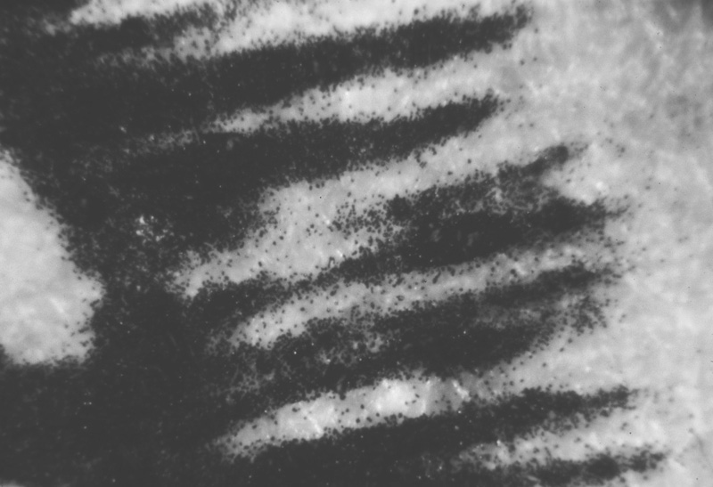
There are some basic tips that will help you differentiate between an original and a copy, whether it is a reproduction or a forgery. The most important rule is to always examine the questionable map outside of a frame. Frames are notorious for hiding key tell-tale signs that a map is not an original. Knowing how the map was typically published is also critical. If the map was published in an atlas or book, it will have a centerfold (or sometimes multiple fold lines), traces of a binder's guard or backstrap on verso, and often text on verso. The type of paper can also be a clear give-away. If the paper is wove or machine-made paper, then the map was not printed before 1800, when these technologies were invented. The thickness, texture, and color of the paper, as well as watermarks in the paper can also be identifying factors. Although paper can naturally shrink and expand, the size of the printed area should be the same within about half a centimeter, so compare the size of the suspect map with a known original. Another key tip is to look at engraving under magnification and note the consistency of the engraved lines. Most modern printing techniques cannot replicate the crisp, continuous and distinct lines that are created by relief or intaglio printing methods. If tiny scattered particles of ink are visible around the printed lines, that is indicative of photocopy and laser printing, which can sometimes be deceptive since they leave a slightly raised line. The best option is always is to compare a suspicious map with an original. Images of original antique maps are readily found online on sites such as the Library of Congress, David Rumsey Map Collection, and numerous other public libraries and map dealers.
Notice the tiny specks of ink surrounding the lines caused by photocopy and laser printing. (Image courtesy of Collecting Old Maps, Manasek, Griggs & Griggs.)
Another key consideration in identifying forgeries is the printing technique that was used with the original map. In addition to the identifying factors listed above, woodcut and copperplate maps must display ink that is slightly raised, not flat like a planographic image or a photocopy. One of the most obvious ways to differentiate an original copperplate map from a fake is to compare the plate mark on both maps. The size and shape of the platemark should match. Copper was an expensive material, so typically the plate is barely larger than the image itself. As a result, platemarks are typically close to the edge of the image, with rounded corners, and often show small amounts of ink residue, giving them a grayish hue. In addition, the paper inside the plate mark should be more compressed than the paper outside the plate mark. Forged platemarks will usually present themselves as an indented line, or as a printed platemark without any indentation. Maps that have been heavily conserved or pressed may lose the physical indentation, however other observable factors should be able to highlight whether they are authentic. The most challenging maps to definitively authenticate are lithographic maps, since the printing technology is still in use today. Looking at these maps under magnification is key to ensure that it was pulled from an original plate and that one of the reproduction methods discussed above was not used. And again knowing how the map was original published and on what type of paper will give clues to its authenticity.
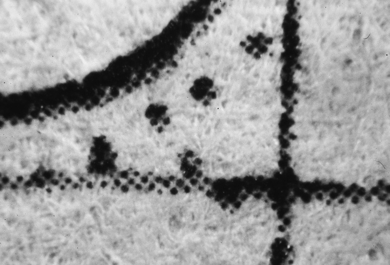
Under magnification, halftone printing appears as tiny dots of ink that are combined with varying intensity to create lines and shapes. Halftone printing is a modern process that was invented in the late 19th century. (Image courtesy of Collecting Old Maps, Manasek, Griggs & Griggs.)
One important point to mention is that while a counterfeit map will have minute differences when compared with an original, even original antique maps will show variation from one example to another. Because of the printing process for woodcut and copperplate maps, examples pulled from the same plate will have minor changes in the darkness or evenness of the ink, ink residue between the engraved lines or along the plate mark, creases in the paper caused by the printing press, or cracking or wearing down of the plate, to name a few. In contrast, multiple examples of the same counterfeit map will be identical, down to the supposed imperfections in the map. Some forgeries have features such as tears, stains, or folds that are actually printed on the map, and will appear in every example.
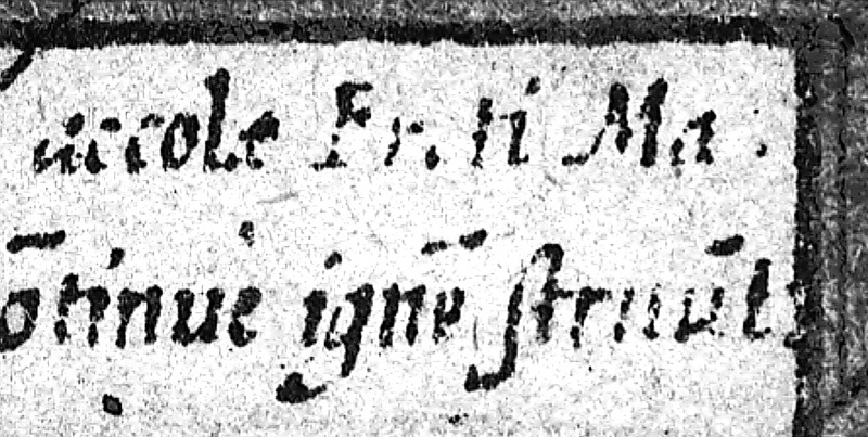
A photo-reproduced lithograph cannot duplicate the crisp, distinct, and continuous lines created by engraved lines. Lines will often blur into one another and text may appear as interrupted segments. (Image courtesy of Collecting Old Maps, Manasek, Griggs & Griggs.)
It is unfortunate that deceitful examples of maps still appear on the market today, and requires all map dealers, collectors, catalogers, and librarians to remain vigilant in closely inspecting each map. Old World Auctions takes authenticity very seriously; every effort is made to ensure that the maps in our auctions come from trustworthy sources, and that each item is carefully inspected by at least two staff members before being placed in auction. Of course the best way to identify a forgery is through experience - knowing what to expect with maps from specific cartographers and time periods. It is always safer to buy from reputable dealers and auction houses that specialize in antique maps, since a well-framed reproduction or fake will often fool those with less expertise. However if you follow the tips above, in particular never buying a map without examining it outside of the frame, you will be well poised to avoid reproductions and forgeries. And beware of deals that are too good to be true - the old adage that "you get what you pay for" is sound advice in the map world.
References
Manasek, F.J., Collecting Old Maps, 2nd edition, revised and expanded by Marti and Curt Griggs, Old Maps Press, Clarkdale, Arizona, 2015.
Van den Broecke, Marcel, Unmasking a Forgery, Mercator's World, Volume 3 Number 3, Astor Publishing Corporation, Eugene, Oregon, May/June 1998.
Campbell, Tony, "How to tell a fake or forgery," Map History / History of Cartography <http://www.maphistory.info/fakesintro.html> (accessed March 10, 2016)