Another year has passed, and we are thankful for all of our consignors and buyers who make our auctions so successful. As we look back on 2015, we wanted to share some highlights and trends from Old World Auctions in the spirit of transparency.
First the Highlights
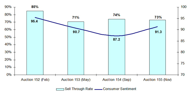
This year started off with a bang, with a record 85% sell-through in our February auction. The latter three auctions of the year ended with 71-74% sell-through, which still compares favorably to the average auction sell-through rate of 70% reported by Rare Book Hub for 2015. Throughout the year there were some stellar results. Here are a few of the top results from our auctions this year:
Auction 152 - Lot 56. Yaggy's Geographical Portfolio, by Levi W. Yaggy, 1893. Sold for $6500 -- 217% above High Estimate
Auction 152 - Lot 203. [Lot of 2] Plan of the City Intended for the Permanent Seat of the Government of the United States… [and] Plan of the City of Washington in the Territory of Columbia, by Norris Peters, 1900. Sold for $1600 -- 727% above High Estimate
Auction 152 - Lot 308. Mapa Geografico del Reyno de Tierra Firme y Sus Provincias de Veragua y Darien, by don Thomas Lopez de Vargas Machuca, 1802. Sold for $4000 -- 500% above High Estimate
Auction 152 - Lot 534. Villes d'Italie / Steden van Italien, by Pierre Mortier, 1705. Sold for $1300 -- 217% above High Estimate
Auction 152 - Lot 724. [Lot of 2] International Yacht Race 1887. Volunteer & Thistle, Just After the Start First Day [and] [Untitled - Yachts], by Armstrong & Co, 1884-88. Sold for $1000 -- 200% above High Estimate
Auction 153 - Lot 133. Map of the United States Canada, Texas & Part of Mexico, by D.F. Robinson & Co., 1844. Sold for $1300 -- 400% above High Estimate
Auction 153 - Lot 228. Geological Map of a Part of the State of California Explored in 1853 by Lieut. R.S. Williamson U.S. Top. Engr., by U.S. War Department, 1856. Sold for $425 -- 213% above High Estimate
Auction 153 - Lot 503. Le Plan de Paris, ses Faubourgs et ses Environs..., by Delisle/Covens & Mortier, 1730. Sold for $3500 -- 250% above High Estimate
Auction 154 - Lot 2. Der Ander Theyl / der Newlich Erfundenen Landtschafft Americae ... so die Frantzosen in Floridam..., by Theodore de Bry, 1591. Sold for $800 -- 229% above High Estimate
Auction 154 - Lot 252. West Point New York, by U.S. Coast and Geodetic Survey, 1883. Sold for $600 -- 353% above High Estimate
Auction 155 - Lot 120. United States in North America, by Richard Phillips, 1809. Sold for $1600 -- 246% above High Estimate
Auction 155 - Lot 243. Map of the Cities of Washington and Georgetown D.C. [and] Johnson's Georgetown and the City of Washington the Capital of the United States of America, by Morrison/Johnson & Ward, 1862-76. Sold for $600 -- 240% above High Estimate
Auction 155 - Lot 275. Map of That Part of the Mineral Lands Adjacent to Lake Superior, Ceded to the United States by the Treaty of 1842 with the Chippewas, by U.S. Gov., 1845. Sold for $1100 -- 440% above High Estimate
Auction 155 - Lot 290. Topographic Map of Long Island, New York, by U.S.G.S, 1913. Sold for $425 -- 213% above High Estimate
Macro Trends
With the volatility in the global economy and general unrest around the world, we wanted to understand our results against broader indicators. Since the majority of our customers are US-based, we compared our overall sell-through rates against U.S. consumer sentiment (from the University of Michigan's Surveys of Consumers), which yielded an interesting correlation:
As the chart depicts, consumer sentiment was highest during our February auction, which also had the highest sell-through rate. The months of May, September and November saw a drop in confidence, which was consistent with what Old World Auctions experienced.
It is also worthy to note the decline of the Euro over the last two years, as many of our European customers have experienced. This decline has made purchasing maps in the United States 20% more expensive for our European customers. Fortunately, we have seen only a modest decline in European participation.
Trends Over the Centuries
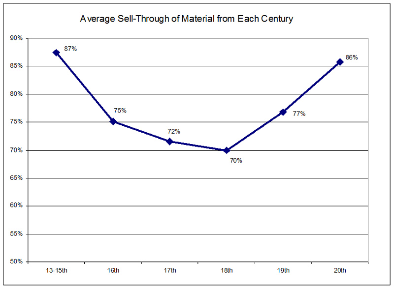
One thing you may have noticed about the top 2015 results at Old World Auctions is that 9 of these 14 lots were maps from the 19th century - a trend that we've seen over the last few years. Our customers have a strong interest in maps from the 19th and 20th centuries, as well as the few items we have from the 15th century and earlier (comprised primarily of Hartmann Schedel leaves and illustrated manuscripts). In fact the average sell-through in our auctions of material from each century presents itself similar to an inverted bell-curve:
Trends by Category
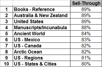
This trend is also apparent when reviewing sell-through and prices realized by subject matter. Of the top ten best-selling categories in our auctions, five of them relate to the United States. The majority of our 19th and 20th century material consists of maps within North America, which makes sense considering the wealth of interesting cartographical developments in the area during that time period. This also corresponds to our customer base, which remains primarily American. Below is a list of the sell-through for the top 10 categories, based on the last 3 years of data.
While most of the strongest selling categories also realize the highest prices, it is not always the case. The strongest realized prices are for maps of the United States, Continent sets, Mediterranean, Manuscripts/Incunabula, Atlases, and Reference books. Ancient World maps are an exception, with strong sell-through but lower prices.
Interestingly, two of the bottom-performing categories are Western Hemisphere and Gulf of Mexico, so not all regions depicting parts of North America are on trend. Other geographies with the lowest sell-through rates over the last 3 years are maps of the Pacific (with the exception of Australia and New Zealand), Holy Land, continent of Africa, and continent of Europe. Although regional maps throughout Europe are also near the bottom of our list, they have been on the rise over the last year and a half. It is also important to note that maps of Holy Land and the continent of Africa achieve higher realized prices when they do sell.
Over the last three years, other trends have become apparent. Maps depicting portions of both Canada and the US have remained steadily popular, whereas maps of Canada alone have been decreasing in sell-through in the last 2 years. There has also been a slight downward trend in regional maps of Asia in the last 2 years, and while maps of the UK were on an upward trend in 2013-14, this year has shown a slight decline. Another upward trend is with maps of Central America, Mexico, and regional maps of South America, with maps of Tierra del Fuego and Magellan's Strait leading the charge. Books of all kinds - atlases, history books, books on exploration, and reference books - have remained on a strong upward trend over the last 3 years.
Overall there are ups and downs with surprises along the way! As we close the books on 2015, we remain optimistic that 2016 will show positive momentum. And with that we wish you all a Happy New Year!