American Atlas Publishers in the 19th Centuryby Joe McAlhany
It is no coincidence that as the United States underwent significant and constant change throughout the 19th century, its commercial cartography evolved as well. As the nation pushed westward, new geographical data poured in, networks of roads, railroads, and canals developed, and new configurations of territories and states appeared. The prospering American population -- which more than tripled from 1810 to 1850 -- understandably had a burning interest in monitoring the growth and progress of their nation, and map and atlas publishers eagerly stepped up to meet the demand, revising and updating their works to reflect even the minutest changes to the country. These publishing companies were able to meet the increased demand thanks to innovations that allowed for faster, cheaper, and easier printing and production. Out of this perfect storm the American atlas emerged as a profitable (for the publishing companies) and informative (for the American public) way to track and visualize America's profound transformation.
Mathew Carey published the first atlas of the United States engraved and published in the United States, Carey's American Atlas, in 1795, but cartography was not his principal interest. The first publisher in America to focus exclusively on maps and atlases was John Melish, a Scotsman who entered the publishing industry in 1812 with his two-volume work Travels in the United States of America in the Years 1806 & 1807, and 1809, 1810, & 1811, which included eight maps drafted by Melish himself. In the next couple years, Philadelphia-based Melish would go on to publish A Military and Topographical Atlas of the United States... (1813), a compilation of successful maps he created related to the War of 1812, and A New Juvenile Atlas and Familiar Introduction to the Use of Maps... (1813-14). One of the mapmaker's biggest achievements was not an atlas but a map: the pioneering work Map of the United States in Connection with the British and Spanish Possessions (1816), a six-sheet map that was one of the first to depict the United States from the Atlantic to the Pacific, and the accompanying text, A Geographical Description of the United States. Melish continued to publish until his death in 1822. His company died with him. Walter W. Ristow summarizes his accomplishments: "Melish played a foremost role in bringing together from many and varied sources the geographical and cartographical knowledge of the period, and presenting it systematically and graphically for the edification and enlightenment of the citizens of the young republic."
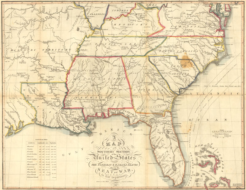
A Map of the Southern Section of the United States Including the Floridas & Bahama Islands Shewing the Seat of War, in That Department, by John Melish, 1813.
One of Melish's key collaborators, the engraver Henry Schenck Tanner, would prove to be a successor of sorts. One of the most important mapmakers and publishers to appear during the Golden Age of American cartography that lasted through the 1820s and 30s, Tanner made his mark with the influential New American Atlas (1823), the final plates of which were distributed less than a year after Melish's death. Highly praised in its time, this landmark atlas established a new standard in American commercial cartography. What set the New American Atlas apart from its competition were its maps detailing the states. Even though all the states but Florida and New York appear in groups, these state maps provided an unprecedented level of detail, delineating topography, towns and cities, roads, canals, and more. Tanner believed his customer base was more interested in seeing their home country in vivid detail than they were in maps of places in the eastern hemisphere. He also insisted on revising the maps whenever new data became available. But rather than forcing customers to shell out another $30 for an updated atlas, Tanner issued these new sheets separately, at a low cost, in color schemes that matched the original atlas. Customers could then amend their old atlases by adding these inexpensive new sheets.
Despite its innovations and critical success, the New American Atlas sold below Tanner's expectations. Publication of the atlas would cease by 1839. But by then Tanner had conceived of a smaller, cheaper atlas, which evolved into A New Universal Atlas, first published in 1836. According to Manasek, Griggs & Griggs, "For nearly a quarter century, the New Universal Atlas was the predominant American atlas." The atlas would be published until 1860 by a number of different publishers including Samuel Augustus Mitchell, Thomas, Cowperthwait, & Co., and Cushings and Bailey. Much of Tanner's subsequent work consisted of revised editions of previous works and publications focused more on the written word than cartography. In 1843 Tanner moved his lucrative company from Philadelphia, then the city for those in the cartographic publishing industry, to New York, likely to avoid switching from engraving to the relatively new manner of reproduction, lithography. Lithography had been around for nearly fifty years at this point in time, but many publishers were slow to adopt the technique because it required large, unwieldy stones. Once the lithographic stones were replaced with zinc printing plates circa 1845, lithography overtook engraving as the main technique of map reproduction. It is somewhat ironic that when the forward-thinking mapmaker died in Brooklyn in May 1858, he was lagging behind the times.
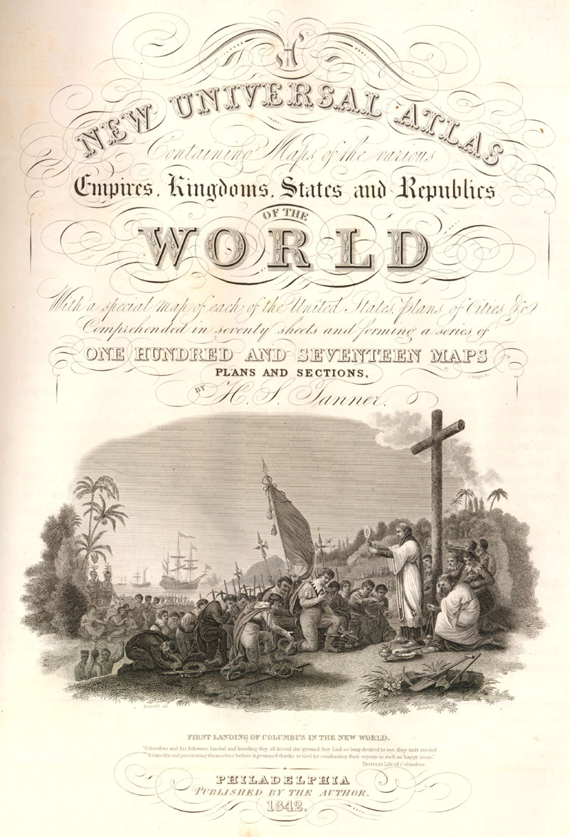
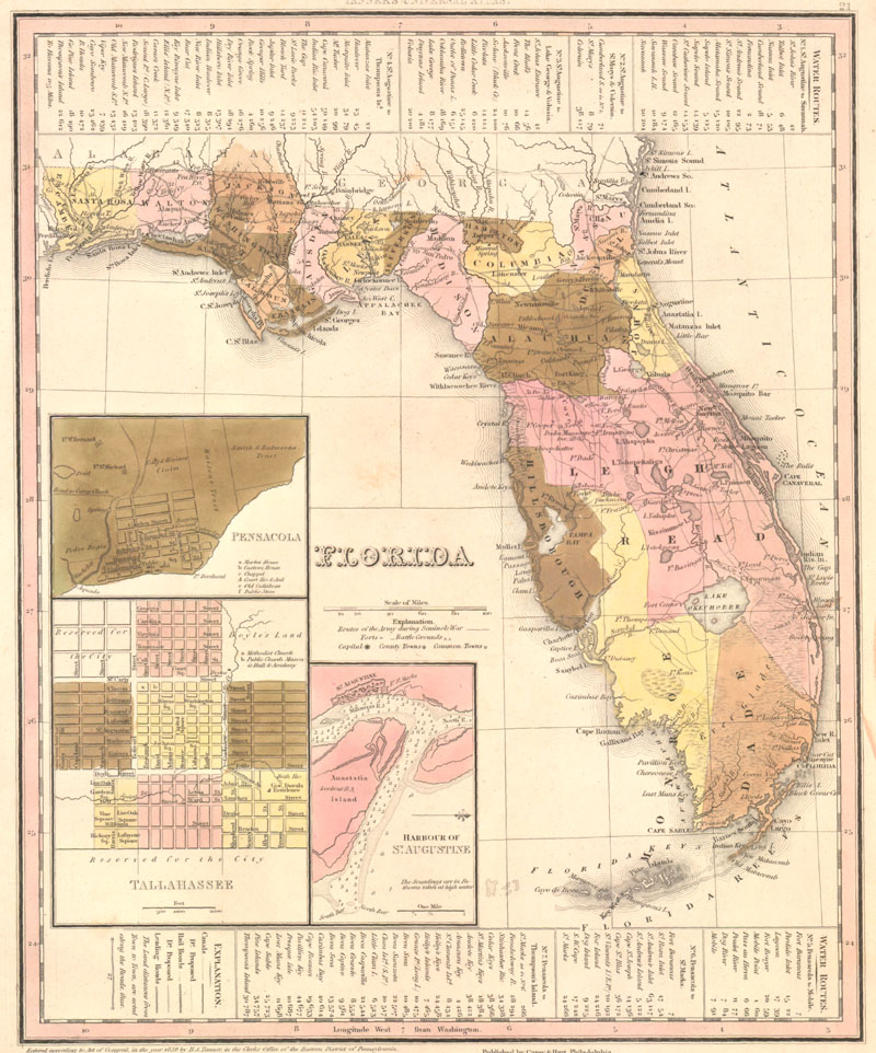
The title page to Tanner's New Universal Atlas published in 1842, and a map of Florida by Tanner, dated 1839.
Tanner's two major atlases established a tradition in American commercial cartography that was carried on by the companies of Samuel Augustus Mitchell and Joseph Hutchins Colton. Despite their lack of proper training in geography or cartography, these savvy businessmen managed to lead the mapmaking industry for decades. Mitchell was born in Bristol, Connecticut, in 1792. Originally a teacher, he found himself consistently disappointed by the quality of the geography textbooks. He moved to Philadelphia and entered map and atlas publishing in 1831 with A New American Atlas. Not to be confused with Tanner's work of the same title, Mitchell's atlas was a revised reissue of Anthony Finley's answer to Tanner's groundbreaking atlas. Mitchell recruited J.H. Young, the engraver who worked on Finley's atlas, and entered a collaboration with him that spanned decades. Young would prove to be an essential collaborator, making up for Mitchell's lack of cartographic expertise by serving as his primary compiler, draftsman, and engraver. In between the publication of A New American Atlas and Mitchell's eventual acquisition of Tanner's New Universal Atlas, his company specialized in maps and travel guides.
Mitchell bought the copyright for Tanner's atlas from Carey and Hart in 1845, and in the subsequent year his company published two editions of the milestone atlas. These editions of the atlas are early examples of the lithographic transfer process in American commercial cartography. Whereas the maps in earlier editions of the New Universal Atlas were engraved on copper plates, with visible plate marks on the sheets, Mitchell's editions are believed to have been reproduced by moving the engraving over to lithographic stones, with no plate marks. Hand colored green borders were also added to the maps. Borders such as these would prove to be popular in the atlases of the latter half of the 19th century, serving as ornamentation on maps that were otherwise more practical and scientific than decorative. Mitchell published the New Universal Atlas intermittently until 1850, when he sold the rights to Thomas, Cowperthwait, and Co. The atlas would transfer hands a few more times before its final edition was published in 1859 by Cushings and Bailey.
In 1860, Samuel Augustus Mitchell Jr. took the reins of his father's company and began publishing the New General Atlas, a replacement for the New Universal Atlas. New editions of the New General Atlas were issued yearly with Mitchell Jr. named as publisher until 1879; the atlas would continue to be published by a variety of publishers until 1893, when it was put out by the A.R. Keller Company under the altered title of Mitchell's Family Atlas of the World. The elder Mitchell continued to work on wall maps and other projects until his death in 1868. When the company he created was at its peak, it employed 250 and sold more than four hundred thousand publications a year.
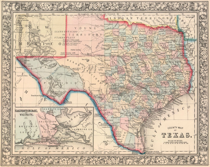
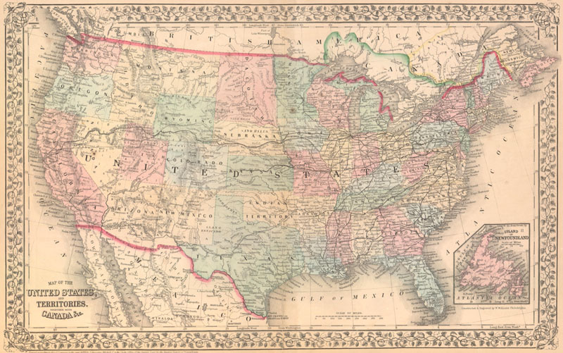
Two maps by Samuel Augustus Mitchell showing evolving borders. Above is County Map of Texas, 1860, and below is Map of the United States, and Territories. Together with Canada &c., 1870.
Along with Mitchell, J.H. Colton (1800-1893) dominated commercial cartographic publishing in America for much of the 19th century. J.H. Colton and Company was founded in New York City in 1831, and the earliest Colton imprint appeared a couple of years later on a re-engraved version of David H. Burr's map of New York from 1831. In the early years of his company, Colton did not have an equivalent to Mitchell's associate J.H. Young -- he had to purchase copyrights from other mapmakers. For the first twenty four years of its existence, J.H. Colton and Company published maps, including railroad and immigrant maps, and guidebooks, but no atlases. That changed in 1855, with the publication of the first volume of the company's original atlas, Colton's Atlas of the World Illustrating Physical and Railroad Geography. Likely compiled by Colton's son George W. (1827-1901), this volume contained lithographed maps of the Americas, with decorative, interwoven borders and hand color. The second volume, featuring maps from the rest of the world, was issued the next year. The distinguishing feature of Colton's atlas was the inclusion of descriptive prose by Richard Swainson Fisher; the other popular atlases of the era were not accompanied by text. The pricy atlas was quickly replaced after two editions in 1857 with the single-volume Colton's General Atlas, with maps produced from steel plates. Colton's General Atlas proved to be a huge success and was updated and reissued various times until 1888.
Within a decade of the company publishing its first atlas, J.H. Colton's sons, George W. and Charles B. (1832-1916), took control of the firm, with George serving in the J.H. Young role, working as cartographer, engraver, and compiler. The company continued to publish until 1892, releasing a number of smaller atlases. By that point in time, most American atlas publishers had shifted to the cheaper (in both cost and quality) wax engraving process, a move that the Coltons were not willing to make.
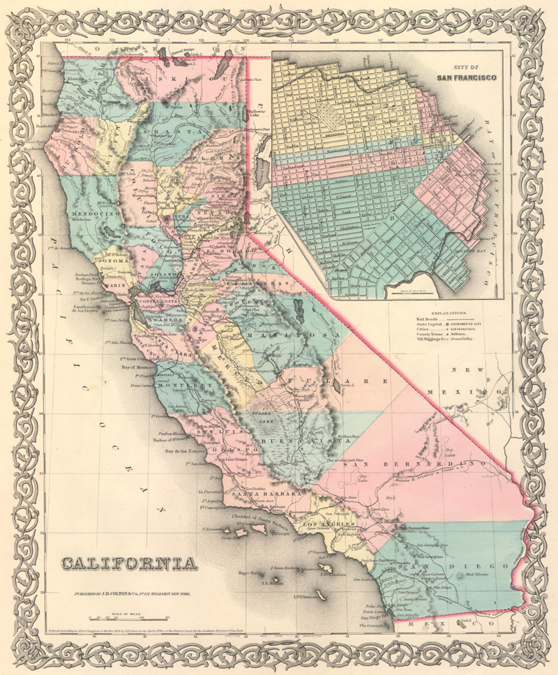
A map of California from Colton's General Atlas, published in 1855, and at right the cover to an 1872 edition.
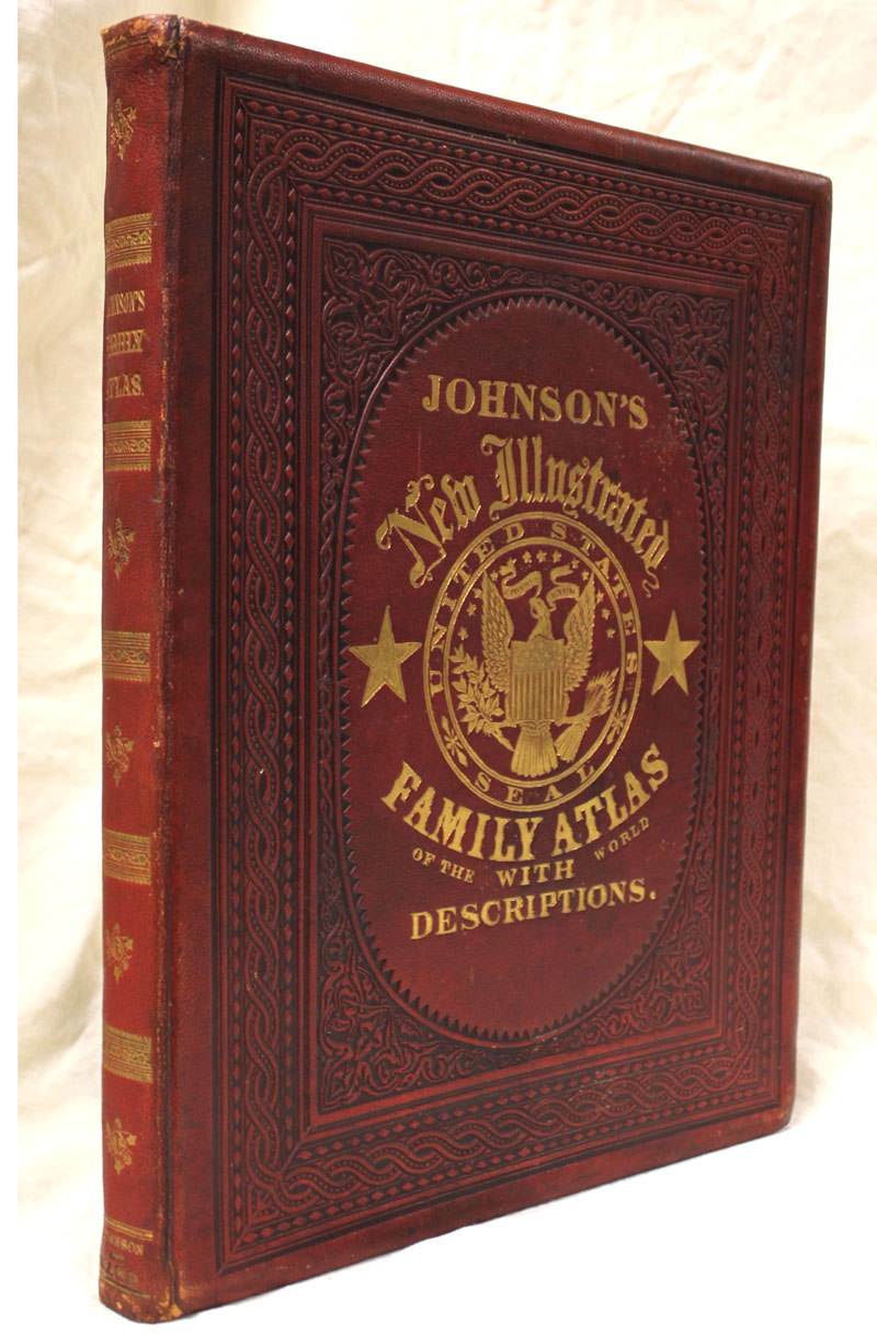
One of Mitchell and Colton's primary competitors was Alvin Jewett Johnson, whose career is ironically and inextricably intertwined with the Colton firm. Johnson got his start as a door-to-door book peddler; at least part of his inventory consisted of Colton's works. He moved into publishing around 1854, eventually relocating to New York City in 1857. Along with his early partner Ross C. Browning, Johnson provided the cash-strapped Colton firm with financial assistance and published some of Colton's General Atlas in 1859 and 1860. At this point, the two companies had in many ways merged, sharing an address and co-publishing works with one another, leading George W. Colton to take a hiatus from his father's company until Johnson's relationship with the elder Colton dissolved around 1865. In 1860, Johnson began to publish Johnson's New Illustrated (Steel Plate) Family Atlas, which was comprised of maps derived or directly taken from Colton, who is credited on the title pages of the atlas' earliest editions. It is likely that this was Colton's way of repaying Johnson for his financial assistance. Johnson started to switch out the Colton maps with original ones in 1863, and by the end of 1865, only seven of the Colton maps remained. The Colton attributions that had been appearing on the atlases' title pages were dropped that same year.
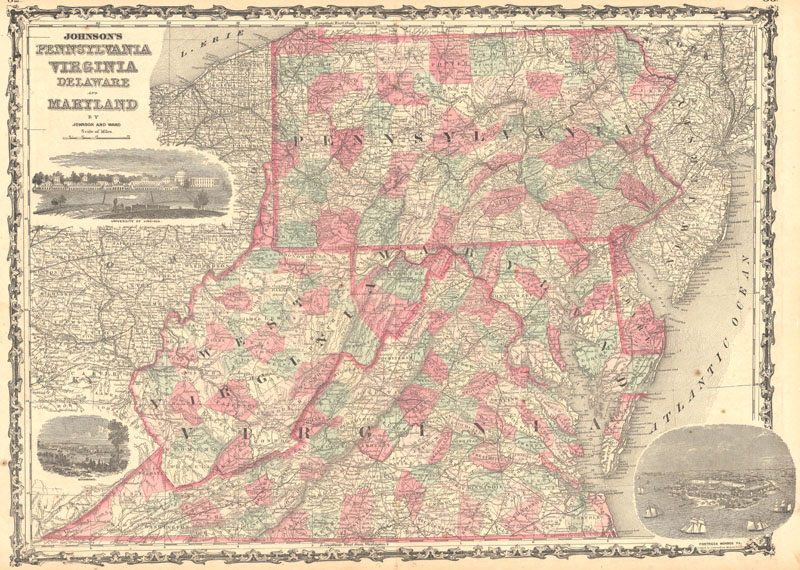
Above is Johnson's Pennsylvania Virginia Delaware and Maryland, by Johnson & Ward, 1863, while below is the cover to Johnson's New Illustrated Family Atlas, published in 1866.
Johnson's Family Atlas was produced every year between 1860 and 1887, except for 1875, 1876, and 1878. The atlas was frequently updated until 1884, when A.J. Johnson died, with maps inserted into the atlas as soon as they were finished being revised, a practice that lead to atlases with the same publish date featuring different maps. It wasn't just the American landscape changing in Johnson's atlas -- the publisher's imprint, the elaborate borders, page numbers, map titles, and text on the verso all varied wildly. Johnson's son, William Warner Johnson, who became a partner in the firm in 1875, kept the business running after his father's death until 1891 or 1892, although no new material was developed once his father passed.
The market for American atlases exploded in the 19th century as the United States took shape. Of the flock of publishers who materialized to meet the American public's demand to chart their own nation's development, Melish, Tanner, Mitchell, Colton, and Johnson are the most prominent. Their maps still endure today, and their complete atlases still show up on the market as well. Collectors are drawn to these works because they present America as a work in progress.
References:
Lourie, Ira S., "Alvin J. Johnson and His Role in 19th Century Map Making in America," The Portolan, Burke, VA, Spring 2012.
Lourie, Ira S., "The Atlases of A.J. Johnson," Ira Lourie's Johnson U.S. Map Project, http://www.johnsonmapproject.org/history.php (accessed June 30, 2015).
Manasek, F.J., Curt Griggs, and Marti Griggs, Collecting Old Maps, 2nd Edition, Old Maps Press, Clarkdale, AZ, 2015.
Ristow, Walter W., American Maps and Mapmakers – Commerical Cartography in the Nineteenth Century, Wayne State University Press, Detroit, 1986.