Collector's Corner: Untold Stories of Map Collectors
This month we have been given rare access to the lives and collections of two antique map collectors. These collectors have over 80 years of experience between the two of them, and have graciously agreed to share the stories of how they built their collections. Whether you are a new or seasoned collector, these anecdotes and tips are certain to inspire you as you continue your own cartographic journey.
A Collector of World and Western Hemisphere Maps Thirty years ago a friend gave Dr. Nolan Kane a framed Albrecht Dűrer woodcut as a birthday gift. The piece was small but charming, and Dr. Kane was fascinated with both the engraving style as well as the old paper on which it was printed. One week later, Dr. Kane was in a plane headed to London and happened upon an article about antique maps in the in-flight magazine.
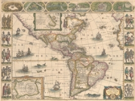
He was intrigued and decided to visit one of the map dealers mentioned in the article during his stay in London. He remembers walking into the dealer's shop and seeing a stack of world maps for 500 GBP each and a stack of maps of the Americas for 200 GBP each. That day he purchased his first map - a rare cartes-a-figures map of the Americas by Jan Jansson, America Noviter Delineata, derived from Jodocus Hondius' map of 1618.
A facial plastic surgeon by trade, Dr. Kane has developed a broad and eclectic range of collections over the years, including vinyl records, Persian rugs, magic realism paintings, pewter, and wooden bird sculptures. His primary passions, however, have been maps and music. Early in his career, Dr. Kane practiced as a voice doctor at the theaters when "rock 'n' rollers came to town," and he can often be found in his music room, playing records on his turntable. He has traveled extensively for both business and pleasure and "never went on a trip without checking out map dealers and vinyl record shops."
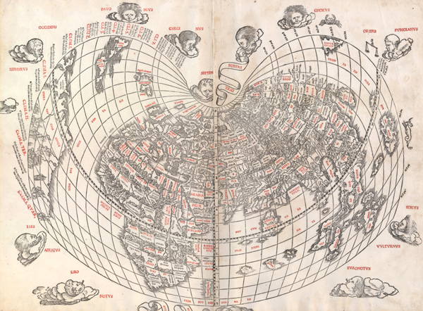
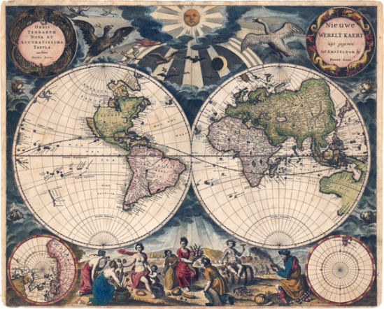
A native of Toronto, Canada, Dr. Kane first focused his collection on Canadian maps. He purchased most of his maps through dealers in the UK, US, Italy and Canada, and on a few occasions found antique maps at flea markets. He befriended many of the dealers, including Graham Arader, Richard Arkway, and Tom Suarez, who shared their knowledge of maps and helped guide him in his collecting pursuits. While Graham Arader was visiting Toronto, Dr. Kane asked Arader the secret to collecting. Arader's advice was to get rid of his Canadian maps, start collecting maps of the world and western hemisphere, and to buymaps in original color. As Dr. Kane recalls, "He forgot to tell me I should be buying rarities, so for a while I was buying the most popular ones." A few years later another dealer visiting Toronto reviewed Dr. Kane's collection and noted that he had "nice solid war horses" but needed to "buy rare ones to anchor the collection." Dr. Kane shifted the focus of his collection again and began buying pieces such as Bernard Sylvanus' untitled cordiform world map of 1511 and Pieter Goos' double-hemisphere world map circa 1666 (Orbis Terrarum Nova et Accuratissima Tabula).
As his collection grew, Dr. Kane selected maps based primarily on aesthetics, although the state of the map and original color were also important factors. As he explains, "You buy a painting or listen to music because it makes you feel good. Likewise looking at a map makes you feel good... I like the patina of the old map, the charm of the people on the sides of the Schedel [world map]. I like to see California as an island floating out there, or see no Mississippi River." For Dr. Kane, maps represented far more than a piece of art - they combined history, aesthetics, and technical skills - and could broaden one's artistic outlook.
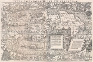
One of his favorite pieces from his collection is Sebastian Munster's two-sheet map of the world, Typus Cosmographicus Universalis, first published in 1532. The map is replete with depictions of cannibals, sea monsters, dragons, angels, and mermaids, all surrounding a world map that was antiquated even for its own time. All of these details lend "a touch of medieval charm" that made this map a perfect fit for Dr. Kane's collection.
Now that Dr. Kane is in his 70's and an empty nester, he and his wife have decided to downsize their beautiful home for a quaint cottage. It was a difficult decision to part with his maps, but he realized that he couldn't go any further with his collection and that it was time to sell. His hope is that his maps find new homes where they can be displayed proudly, as they have been on the walls of his home for so many years.
Although he doesn't consider himself an expert on collecting, Dr. Kane does have a few words of advice for those just starting their map collections. He recommends buying what you like, but confining your interests to a particular area or time in history. Always buy maps in the best condition you can afford, and "don't worry about spending that extra 20% if it's something you love." And finally, be very patient; building a collection takes years and there are some maps that are worth the wait.
Dr. Kane's collection of maps will be featured throughout our auctions in 2014, beginning in February with world maps by Sylvanus, Pitt, Visscher, and Hondius/Le Clerc, as well as world and western hemisphere maps by Munster and Ortelius.
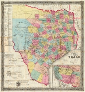
A Collector of Texas Maps When the boxes arrived in our offices, we couldn’t wait to open them. Inside the boxes, each large enough to fit a table-top globe, were impressive stacks of maps, mostly focused on Texas, with a special concentration on the era immediately preceding its status as a republic on through to its early years as a state.
The collector, who wishes to remain anonymous, grew up in Houston and, after serving as an army officer during World War II, worked in construction while attending school in Austin. After completing his studies he remained with the same company for nine years, progressively moving up through the ranks. Then came the time to strike out and start his own business, which eventually grew into a medium-sized commercial construction company.
He began collecting in the early 1960s, after his wife “ignited” his interest in maps with a birthday present: an army engineer’s map of early Texas. The region’s complicated and dramatic history fascinated him and led to Texas becoming his chief collecting interest. “One has to be careful about not taking a shotgun approach,” he says. “A dealer friend advised me to slow down and have a focus – so I’ve focused on Texas maps.”
During a trip to the 1964 World’s Fair in New York City with his son, the collector met and purchased a few maps from Lawrence Lane, one of the first dealers he became acquainted with on his long collecting journey. In the years that followed, he grew his collection primarily by purchasing from various dealers and auctions (both traditional and online). The three key variables that have guided his selection process are price, condition, and most importantly, whether or not the item fit the focus of his collection. Establishing relationships with informative dealers and amassing an extensive cartographic reference library helped the collector to build his base of knowledge as his collection developed.
When asked about his specific goals for his collection, he explains, “I just collected as I went along, and was constantly on the look for things.” As an example, he offers a story about three maps (of Texas, of course) purchased for a low price at a shop in San Francisco in the early 1970's. “At that time I knew I was buying something of value but didn’t really know what I had bought until I brought them home and researched them and discussed them with others,” he remembers. The research revealed that the maps were worth a pretty penny. He sold them in an auction years later for what he describes as a “huge amount of money.” “That was the best map investment I ever made,” he says.
One of his past interests as a collector was the surveyor and cartographer Charles Pressler, known for his work on various Texas maps starting in the late 1840s. A native of Germany, Pressler became a surveyor prior to immigrating to the United States in 1845. The collector describes the thrill of finding a couple of maps with the imprint of “Preslar” – the original German spelling of the mapmaker’s name, before it was anglicized. Maps of Texas that were issued by Charles Pressler are quite rare and valued by collectors of Texas maps.
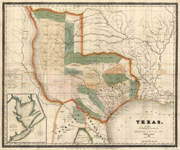
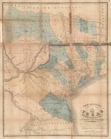
When asked why he has decided to part with his maps, the collector replies, “I’m 91 years old, and none of my children are interested in map collecting, so it’s best to get out of them what I can now, and savor the enjoyment I’ve had over the years in map collecting.” He already sold what he considers the two most prized items of his collection many years ago at auction in California: Texas by David H. Burr (1833) and Stephen F. Austin’s Genl. Austins Map of Texas with parts of the Adjoining States... (1840). The only maps that he can’t bear to part with are the army engineer's map his wife first gave him, as well as the index sheet and nine sheets from Popple’s scarce 20-sheet map of the British Empire in North America. He is still hoping to find the remaining sheets to complete Popple’s map, now the sole focus of his map collecting pursuits.
For novice collectors, he suggests that they keep focused and don’t try to collect too many types of maps. He also recommends maintaining a catalog, preferably electronic, of their collections so that they can keep tabs on what items they have and what they paid for them. But aside from those more practical matters, it is important to remain passionate. “Find out what you are really interested in and stick to it,” he advises. “You’re going to make some mistakes, and you’re going to have some triumphs. It’s the fun and joy of collecting, and it’s given me a lot of pleasure over the years.”
Many maps of the United States, Texas and the Southwest from this remarkable collection will be listed in upcoming auctions through Old World Auctions. The maps range from the mid-16th to late 19th centuries and include cartographers such as Ruscelli, Sanson, Van der Aa, Moll, Bellin, Melish, Flemming, Wyld, Mitchell, Arrowsmith, Bradford, and Burr.