Catalog Archive
Auction 97, Lot 441

"A New Chart of the Indian Ocean", Heather, William

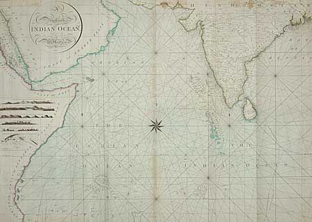
Subject: Indian Ocean

Period: 1799 (dated)

Publication: Heather & Williams

Color: Hand Color

Size:
35.8 x 49.2 inches
90.9 x 125 cm
Download High Resolution Image
(or just click on image to launch the Zoom viewer)

Beautifully engraved and titled map on two sheets, joined. Large compass rose at the center, seas are filled with rhumb lines, islands, reefs, shoals and soundings. Extends from the Red Sea to the delta of the Ganges. Large insets show land elevation as seen from sea at Felix Arabia, the Malabar Coast, Coast of Choromandel, Magalor and Cape Comorin. Plus a large plan showing the harbor and city of Brava. For nearly fifty years William Heather was a noted publisher and dealer in sea charts. This chart, drawn by J. Norie (Teacher of Navigation), is a suburb example of these detailed and colorful navigational sea charts. Norie was the most celebrated mathematician and hydrographer of his day and eventually took over from Heather.

References:

Condition: B

A few flaws, but very good condition nonetheless for a map of this size. Toned along centerfold. On sound and thick hand laid paper.

Estimate: $800 - $1,200

Sold for: $475

Closed on 12/5/2001

Archived