Catalog Archive
Auction 96, Lot 83

"America Septentrionalis, Concinnata juxta Observationes Dnn Academiae Regalis Scientiarum…", Lotter, Tobias Conrad

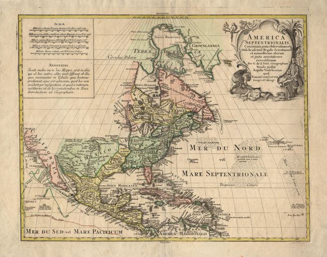
Subject: North America

Period: 1760 (circa)

Publication:

Color: Hand Color

Size:
22.5 x 17.8 inches
57.2 x 45.2 cm
Download High Resolution Image
(or just click on image to launch the Zoom viewer)

This is Lotter's version of Guillaume de l' Isle's foundation map of North American (1700). The Great Lakes are based on the Coronelli model showing the French strong points at Tadousac, Quebec, Fort Sorel, Montreal and Fort Frontenac. The English settlements are confined east of the Alleghenies with Fort and River Kinibeki (Kennebec) as the border between New England and Acadia. The Mississippi valley area is shown well developed with French settlements. The Spanish territories in the southwest are named Nouveau Mexique with a curious smaller territory including Santa Fe and the surrounding pueblos named Nouv Mezique. Numerous tracks in the Pacific show the routes of different 16th century voyages. The most interesting aspect of the map is the region of California. De l' Isle was the first cartographer to revert to a peninsula form for California. Lotter follows that here, but engraved the map in such a way as to leave the possibility still open for the island theory. Large (uncolored) cartouche featuring a Native Americans and a ship's captain.

References: Tooley (America) #34, p. 19.

Condition: A

Couple of small tears repaired with tissue on verso.

Estimate: $1,100 - $1,300

Sold for: $900

Closed on 9/12/2001

Archived