Catalog Archive
Auction 93, Lot 146

"A Geological Map of the Black Hills, by Professor N. H. Winchell, To Accompany the Report of Capt. William Ludlow, U.S. Engineers", U.S. Corps of Engineers

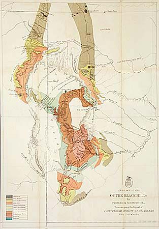
Subject: Dakota Territory

Period: 1875 (circa)

Publication:

Color: Printed Color

Size:
17.3 x 25.5 inches
43.9 x 64.8 cm
Download High Resolution Image
(or just click on image to launch the Zoom viewer)

This colorful geological map was done by Professor N.H. Winchell and published in "Report of a Reconnaissance of the Black Hills of Dakota, made in the summer of 1874 by William Ludlow. The map is attractively colored to bring out the geological findings. It is interesting to note that the troops accompanying the surveyors were under the command of L. Col. G.A. Custer and were not molested by hostile Indians. Just two years later the major engagements of Crook at Rosebud and Custer at Little Big Horn would take place in the same general area.

References: Wheat (TMW) 1251.

Condition: A

Light toning along folds.

Estimate: $100 - $150

Sold for: $95

Closed on 12/6/2000

Archived