Catalog Archive
Auction 92, Lot 101

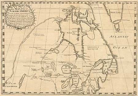
"A new Map of Part of North America From the Latitude of 40 to 68 Degrees. Including the late discoveries made on Board the Furnace Bomb Ketch in 1742…", La France, Joseph

Subject: Colonial United States and Canada

Period: 1744 (published)

Publication: An Account of the countries adjoining to Hudson's Bay …

Color: Black & White

Size:
19 x 13 inches
48.3 x 33 cm
Download High Resolution Image
(or just click on image to launch the Zoom viewer)

This scarce and significant map illustrates the controversy over the long sought-after Northwest Passage. The map was commissioned by Irish landowner, Surveyor-General, and parliamentarian Arthur Dobbs, who disputed the Hudson Bay Company's monopoly and its failed expeditions in search of a passage to the Pacific. The map was compiled from information supposedly gathered by Joseph La France, a "French Canadese Indian" (Metis) fur trapper, during his travels in the region between 1739 and 1742. The fascinating map depicts a severely truncated western unknown coast connecting to Hudson Bay at Rankin's Inlet, with another possible connection at Lovegrove's opening. An elaborate river system connects Hudson Bay with the Lake of Woods, with a short portage shown to Lahontan's famous Long River. Finally, the open-ended Lake Tahuglauk lies west of a mountain range in a region named Part of California. According to Verner & Stuart-Stubbs, "In spite of the inaccuracies of the map it remains an important contribution to the cartography of the interior reaches of central Canada."

References: Verner & Stuart-Stubbs #21; Kershaw #422.

Condition: A

Issued folded and now pressed flat with fold intersections reinforced with Japanese tissue. Tiny puncture also professionally repaired.

Estimate: $4,500 - $5,000

Sold for: $4,000

Closed on 9/13/2000

Archived