Catalog Archive
Auction 91, Lot 115

"A New Map of the English Empire in America viz Virginia, Maryland, Carolina, Pennsylvania, New York, New Iarsey, New England, Newfoulndland, New France &c",

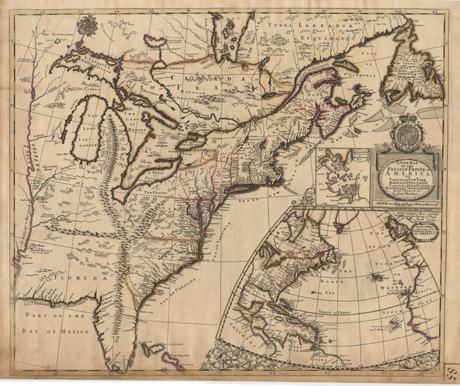
Subject: Colonial United States

Period: 1695 (circa)

Publication:

Color: Hand Color

Size:
19.5 x 23.25 inches
49.5 x 59.1 cm
Download High Resolution Image
(or just click on image to launch the Zoom viewer)

A scarce and stunning map of eastern North America with a prominent, entirely fictitious, mountain range extending from Michigan, connecting with the Appalachians, and continuing into Florida. The map closely follows Richard Daniel's map of 1679 and is based on numerous Jesuit and French sources for information on the Great Lakes and Canada. In the Carolina and Virginia areas the features of Lederer's maps are seen, including "Ashley Lake", the "Large Savana", and the "Desert Arenosa". Along with the title cartouche, surmounted by the royal arms, is a large inset map of the North Atlantic showing the eastern part of North America and the West Indies, as well as the coastlines of Europe and Africa. Above that is a smaller inset of Boston and vicinity. According to Kershaw this is the second state with the addition of Christopher Brown's name under cartouche. Ref: Tooley (America), page 63; Kershaw #323, Karpinski #46; and Cummings #172. Lovely original outline color. Light browning along bottom border. Manuscript ink page number in lower margin. Professionally backed with Japanese tissue to strengthen areas of light oxidation. $12,500 RESERVE

References:

Condition: A+

Estimate: $14,000 - $16,000

Sold for: $11,000

Closed on 6/14/2000

Archived