Catalog Archive
Auction 192, Lot 39

"Total War Battle Map",

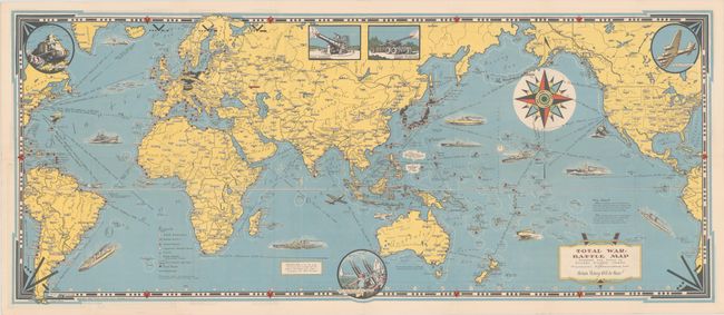
Subject: World, World War II

Period: 1943 (dated)

Publication:

Color: Printed Color

Size:
35.5 x 14.8 inches
90.2 x 37.6 cm
Download High Resolution Image
(or just click on image to launch the Zoom viewer)

This elaborate wartime map centered on the Pacific theater of war was created by Ernest Dudley Chase. It locates numerous Allied naval bases, railroads, British & French colonial possessions, and the Axis power countries in menacing black. The oceans are filled with illustrations of Allied military power including ships, submarines, and aircraft with distances between various ports noted. Illustrations along the border feature "A Yank Tank", "Flying Fortress", and a "New Anti Aircraft Gun Machine." Chase describes his production as "A Battle Map, to set the stage for 'total war' on land and sea; And, in the border, just a hint - A prayer - for total Victory!" The verso contains three smaller maps: Europe, English Channel, and the region around Italy. Issued with compliments of Rust Craft Publishers in Boston. Self-folding.

References:

Condition: A

Clean and bright, issued folding.

Estimate: $275 - $350

Sold for: $190

Closed on 4/26/2023

Archived