Catalog Archive
Auction 192, Lot 143

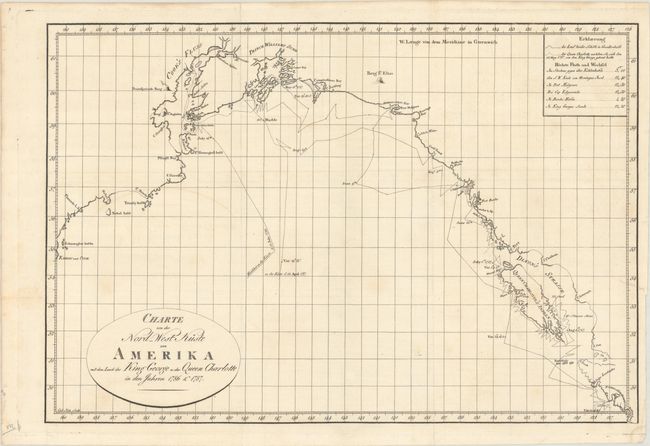
"Charte von der Nord-West Kuste von Amerika mit dem Laufe des King George u: der Queen Charlotte in den Jahren 1786 & 1787",

Subject: Western Canada & Alaska

Period: 1791 (published)

Publication: Geschichte der Reisen, die seit Cook an der Nordwest- und Nordost-Küste von Amerika...

Color: Black & White

Size:
17.4 x 11.8 inches
44.2 x 30 cm
Download High Resolution Image
(or just click on image to launch the Zoom viewer)

This is the German issue of the map "To the Right Honorable the Lords Commissioners ... this Chart of the North West Coast of America, with the Tracks of the King George and Queen Charlotte in 1786 & 1787..." The chart details the route of exploration from Nookta Sound on Vancouver Island north to Cook Inlet in Alaska. Shows an erupting volcano west of Cook Inlet that is probably Mt. Redoubt based on its location. Engraved by Carl Jack. Published in Geschichte der Reisen, die seit Cook an der Nordwest- und Nordost-Küste von Amerika und in dem nördlichsten Amerika selbst von Meares, Dixon, Portlock, Coxe, Long u. a. m. Unternommen Worden Sind by Georg Forster.

References: Wagner (Northwest) #732.

Condition: B+

A sharp impression, issued folding on a bright sheet with a Strasbourg Lily watermark. There is minor soiling and offsertting, a small dampstain at bottom right, and a 1 cm binding tear at right that has been closed on verso with archival tape.

Estimate: $275 - $350

Unsold

Closed on 4/26/2023

Archived