Catalog Archive
Auction 191, Lot 375

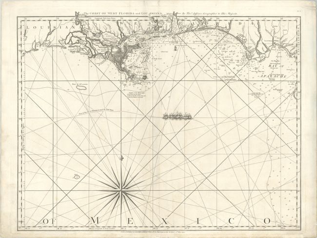
Important 18th Century Map of Gulf Coast

"The Coast of West Florida and Louisiana", Jefferys/Laurie & Whittle

Subject: Gulf of Mexico

Period: 1794 (dated)

Publication: A New Edition, Much Enlarged of the Second Part of the North American Pilot

Color: Black & White

Size:
24.8 x 19.3 inches
63 x 49 cm
Download High Resolution Image
(or just click on image to launch the Zoom viewer)

Thomas Jefferys was one of the most important English map publishers of the 18th century. His work included prints and maps of locations around the world, but his most notable maps are of North America and the West Indies. He began his career in the map trade in the early 1730s, working as an engraver for a variety of London publishers, and eventually setting up his own shop. In 1746, he was appointed Geographer to the Prince of Wales, and in 1760 he became Geographer to the King. These titles granted access to manuscripts and cartographic information held by the government. In the early 1760s he embarked on an ambitious project to produce a series of English county maps based on new surveys, but ran out of money and filed for bankruptcy in 1766. He then partnered with London publisher Robert Sayer, who reissued many of Jefferys plates and continued to issue new editions after Jefferys' death in 1771. Jefferys' American Atlas and the accompanying West-India Atlas, published post posthumously, are considered his most important cartographic works.

This is the western sheet of a 2-sheet map of the Gulf Coast and Florida. First published in 1775, this chart was one of the most important maps of Florida, being the earliest relatively accurate map of the region. The hydrographic detail of the coastline and the channels is excellent and it remained the standard sailing chart for the Florida seas during the last part of the 18th century. This sheet shows the coastline from Cabo del Norte, Louisiana, through Apalachee Bay, Florida. Detail is primarily confined to the coastline with harbors, inlets, bays, river entrances, soundings, rocks, shoals, and currents carefully noted. Several forts, settlements, and villages are located. The map is ornamented with a dramatic compass rose, rhumb lines, and a fleet of sailing ships marking "From la Vera Cruz to Havanna to avoid the Trade Winds." In the second state, the bay at the mouth of the Mississippi River was updated and named "Bay of Spiritu Santo;" this is the third state with the imprint of Laurie & Whittle at bottom. Sheet number DF.3 printed at upper right.

References: cf. Sellers & Van Ee #1608; Shirley (BL Atlases) M.JEF-5d #20; Stevens & Tree (MCC-39) #26c.

Condition: B+

A sharp impression on a bright sheet with a large Strasbourg Lily watermark, minor soiling, a couple of extraneous creases, and short edge tears that have mostly been repaired.

Estimate: $1,400 - $1,700

Unsold

Closed on 2/8/2023

Archived