Catalog Archive
Auction 190, Lot 577

One of the Earliest Maps of the Whole Continent of Asia

"Tabula Orientalis Regionis, Asiae Scilicet Extremas Complectens Terras & Regna", Munster, Sebastian
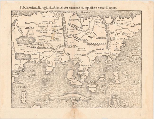
Subject: Asia

Period: 1552 (circa)

Publication: Cosmographiae Universalis

Color: Black & White

Size:
13.6 x 10.2 inches
34.5 x 25.9 cm
Download High Resolution Image
(or just click on image to launch the Zoom viewer)

Sebastian Munster (1489 - 1552) was one of the three most renowned cartographers of the sixteenth century, along with Mercator and Ortelius. Munster's Geographia and Cosmographia Universalis were two of the most widely read and influential books of the period. His editions of Ptolemy's Geographia, published between 1540 and 1552, were illustrated with 48 woodcut maps, the standard 27 Ptolemaic maps supplemented by 21 new maps. These new maps included a separate map of each of the known continents and marked the development of regional cartography in Central Europe. The antique geography was a prelude to Munster's major work, the Cosmographia, which was published in nearly 30 editions in six languages between 1544 and 1578 and then was revised and reissued by Sebastian Petri from 1588 to 1628. The Cosmographia was a geographical as well as historical and ethnographic description of the world. It contained the maps from the Geographia plus additional regional maps and city views with nearly 500 illustrations which made it one of the most popular pictorial encyclopedias of the sixteen century.

This is one of the earliest maps of the whole continent based on the recent geographical discoveries by Portuguese navigators. The outline of the Asian mainland is relatively well established. India appears as a peninsula and Sri Lanka, called Zalon, is correctly located. Cambay, Goa, and Cannonore are all shown, reflecting the Portuguese presence on India's west coast. Malacca is correctly located on the Malay Peninsula and the Indonesian island of Sumatra has inherited the name Taprobana from Sri Lanka, but also bears the name Sumatra. Java appears as two islands, Java Maior and Java Minor. The famed Spice Islands of Moluccas are located, but oddly shaped. The coastline of China is fairly accurate but Korea and Japan are absent. Northern Asia, named India Superior, extends off the map, reflecting the belief that the northern reaches of the New World were connected to Asia. An archipelago of 7448 islands lies off the eastern coastline, a remnant from the reports of Marco Polo. The Indian Ocean is filled with a huge sea monster and a fantastic two-tailed mermaid. Latin text on verso.

References: Yeo #2; Walter #8; Mickwitz & Miekkavaara #155-12.

Condition: B+

A nice impression with minor toning along the centerfold and a stain at upper left caused by remnants of cello tape on verso from an old repair. There are light damp stains confined to the blank margins.

Estimate: $950 - $1,200

Sold for: $700

Closed on 11/16/2022

Archived