Catalog Archive
Auction 190, Lot 329

Superb Pair of Satirical Maps Showing Political Changes in Europe from 1870-1914

"Karte von Europa im Jahre 1870 nach einem Franzosischen Holzschnitte / Karte von Europa im Jahre 1914",

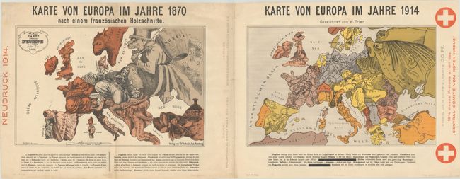
Subject: Europe, World War I

Period: 1914 (published)

Publication:

Color: Printed Color

Size:
36.5 x 14 inches
92.7 x 35.6 cm
Download High Resolution Image
(or just click on image to launch the Zoom viewer)

This single sheet includes two satirical maps of Europe to show the political changes from 1870 during the Franco-Prussian War to 1914 during World War I. German text below each map describes each country's character and involvement in the war at the time. Published by Reklameverlag Ernst Marx and Verner & Schumann in Berlin.

On the left is a German edition of Paul Hadol's map from the outset of the Franco-Prussian War. Various countries and regions are represented by human and animal caricatures with props to help illustrate the situation. At the center of the conflict are France and Prussia, with France depicted as a bearded soldier attempting to thwart the advances of Prussia with a bayonet. Prussia appears as a stocky Otto von Bismarck with his hat pulled over his eyes and kneeling on Austria, a sleeping soldier, while his right hand completely covers Holland. England is shown as an enraged old woman turning her back on the mainland, with Ireland, a small bear, on a leash. The Balkans are represented by a man who is yawning and just beginning to awake. Russia is depicted as the bogey-man, trying to fill up his basket (with shadowy bear-like figures behind him). And both Spain and Turkey are shown as women, passively smoking and lounging.

On the right is Walter Trier's map created shortly after the outbreak of WWI. Trier, a German-Jewish artist, was born in Prague and emigrated to Germany to study art. After the war he became a strong anti-fascist, fleeing to England in 1936. However this map is pro-Germany, with Germany and Austria-Hungary depicted as soldiers, striking out in several directions. Belgium has already been "caught" by Germany and serves as his gun. Russia is seen as a giant, trying to swallow its neighbors. Spain sits back and watches the turmoil while France "courageously" pulls itself back. Serbia is depicted as a pig and Montenegro is a louse. Italy looks frightened with his hands in his pockets. Romania is depicted as Carol I, who ruled until his death on October 10, 1914. Within the text below the map are redactions masking the descriptions of Italy and Romania. While Italy was described within the text as "faithful until death" due to its participation in the Triple Alliance, Italy proclaimed neutrality in August 1914 and its support was therefore no longer certain. Likewise, Carol I of Romania favored Germany prior to the war, but after his death in 1914 Romania also declared itself neutral. Another interesting facet of this map is the prominent note at right indicating that 10% of the price of the map (30 Pf.) would be given to the Red Cross.

These political cartoon maps are now quite rare, due to their ephemeral nature.

References:

Condition: B+

Light soiling that is more prominent at left, with some extraneous creasing. There are a few short tears perpendicular to the centerfold that have been archivally repaired on verso.

Estimate: $1,400 - $1,700

Sold for: $700

Closed on 11/16/2022

Archived