Catalog Archive
Auction 190, Lot 29

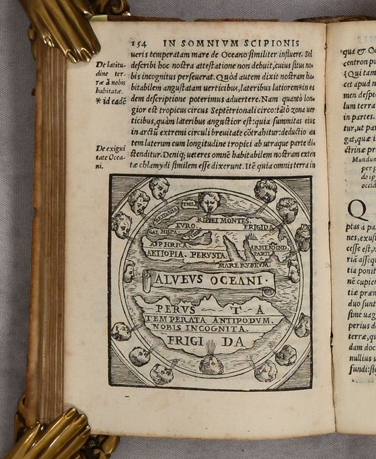
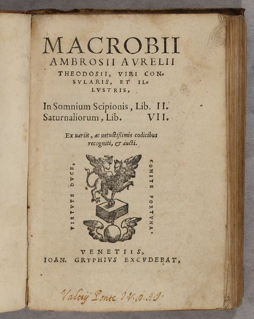
"Macrobii Ambrosii Aurelii Theodosii, Viri Consularis, et Illustris, in Somnium Scipionis, Lib. II. Saturnaliorum, Lib. VII…", Macrobius, Ambrosius Aurelius Theodo

Subject: Ancient World

Period: 1560 (circa)

Publication:

Color: Black & White

Size:
4.5 x 6.3 inches
11.4 x 16 cm
Download High Resolution Image
(or just click on image to launch the Zoom viewer)

This work, written by Ambrosius Macrobius, is a commentary on Cicero's Dream of Scipio. It includes a rare woodcut map of the world (3.1 x 3.1") illustrating Cicero's interesting theories. This diagrammatic map shows two distinct regions of the earth. The inhabited Afro-Eurasian continent was balanced by an unknown, and relatively equal, landmass (Temperata Antipodum Nobis Incognita) on the other side of an impassable torrid zone (Perusta) and a great boiling sea (Alveus Oceani). It was this notion of antipodean balance and landmass equivalence that continued to attract Renaissance minds to the otherwise outmoded geographical ideas of Macrobius. Distinguished cartographers like Mercator and Ortelius would later incorporate Macrobius' model into an immense southern continent (Australis Incongita) to balance the known lands of the world, and the division of the world into climactic zones is still in use today.

Macrobius was a 5th century Roman neoplatonic philosopher. His commentary on Cicero’s Somnium Sciponis was of great influence in the Middle Ages and gained popularity with the advent of printing. First published in Brescia in 1483, numerous editions appeared throughout the 16th century. His commentary includes several chapters dealing with his own conception of the world and the universe. It also contains references to many facets of the scientific knowledge of his time, including references to physics, astronomy, and mathematics. While the title page is undated, the style of wind heads is consistent with Sebastian Gryphius circa 1560. 12mo, 567 pages and extensive index. Hardbound in vellum with manuscript title on spine.

References: Shirley #13; King (2nd ed.) pp. 34 & 193-5; Moecker (MapForum #4), pp. 26-30.

Condition: B+

The map is clean, bright and fine. Other text pages are mostly clean with occasional minor staining. Binding is scuffed and soiled, especially on the spine.

Estimate: $1,000 - $1,300

Sold for: $700

Closed on 11/16/2022

Archived