Catalog Archive
Auction 190, Lot 11

"Nouveaux Mappemonde ou Globe Terrestre avec des Tables et des Remarques pour Conduire a la Connoissance de la Geographie et de l'Histoire", Chatelain, Henry Abraham
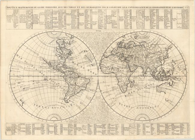
Subject: World

Period: 1720 (circa)

Publication: Atlas Historique...

Color: Black & White

Size:
26.6 x 18.8 inches
67.6 x 47.8 cm
Download High Resolution Image
(or just click on image to launch the Zoom viewer)

This bold world map from Chatelain’s monumental, seven-volume atlas combines a wealth of information and geographical observations. The two hemispheres are divided into a grid with a corresponding key to the tables surrounding the map, which identifies the locations of principal cities, mountains, rivers, lakes, islands, and other geographical features. The routes of prominent explorers are traced with the dates of their voyages. Australia and New Guinea are joined into one large landmass with only the southern tip of Tasmania outlined.

North America is still vastly unexplored with an uncharted western coastline. This map shows California as a peninsula, in contrast to Chatelain’s renowned Carte Tres Curieuse from the same atlas that depicts it as an island. The Atlas Historique was published between 1705 and 1720 when the question of California’s insularity was hotly contested among leading cartographers. It was common practice for publishers to present both versions of the controversy.

References:

Condition: B+

A sharp impression, issued folding on a bright sheet with the watermarks of a Strasbourg Lily and "Villedary" and minor soiling. The sheet has been backed in thin, archival tissue with professional repairs to three tears: one east of North America, one east of South America, and one extending from the bottom of the sheet near the center.

Estimate: $550 - $700

Sold for: $325

Closed on 11/16/2022

Archived