Catalog Archive
Auction 190, Lot 104

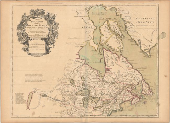
Delisle's Seminal Map of Canada and the Great Lakes in Contemporary Color

"Carte du Canada ou de la Nouvelle France et des Decouvertes qui y ont ete Faites...", Delisle, Guillaume

Subject: Colonial Northeastern United States & Canada, Great Lakes

Period: 1703 (dated)

Publication:

Color: Hand Color

Size:
25.6 x 19.6 inches
65 x 49.8 cm
Download High Resolution Image
(or just click on image to launch the Zoom viewer)

Delisle's map of Canada and the Great Lakes is one of the most outstanding and influential maps of the eighteenth century. The Great Lakes are portrayed correctly for the first time, and Detroit marks its debut on this map, only two years after its founding. Delisle's cartography is very meticulous and adds new information from Joliet, Franquelin, and the Jesuit explorers. It correctly positions the Ohio River but confuses its name with the Wabash River. West of the Mississippi Lahontan's fictitious Riviere Longue is prominently depicted. In Canada special attention is given to the rivers and lakes between Hudson Bay and the St. Lawrence, and Lac de Assenipoils (Lake Winnipeg) connects to Hudson Bay. Sanson's three islands of the Arctic are retained. Exquisite cartouche with a beaver, natives (one of whom is bearing a scalp), a priest, and friars, engraved by Guerard. This is the fourth state, with Delisle's address reading "sur le Quai de l'Horlage a l'Aigle d Or," and the additional note above the distance scales erased except for the word "Bourse."

References: Kershaw #311; cf. Schwartz & Ehrenberg p. 135-137, Plt. 80; Tooley (Amer), p. 20, #37.

Condition: B+

A nice impression on a lightly toned sheet with contemporary wash and outline color and the watermark of the Maltese cross encircled by rosary beads. There are a few small stains in the bottom corners of the map, an archivally repaired centerfold separation confined to the bottom blank margin, and marginal dampstaining.

Estimate: $2,000 - $2,300

Sold for: $1,100

Closed on 11/16/2022

Archived