Catalog Archive
Auction 189, Lot 85

One of the Earliest Maps to Acknowledge the United States in the Title

"L'Amerique Septentrionale, ou se Remarquent les Etats Unis", Brion de la Tour, Louis

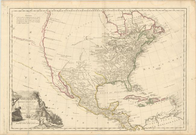
Subject: North America

Period: 1788 (dated)

Publication:

Color: Hand Color

Size:
29 x 20.3 inches
73.7 x 51.6 cm
Download High Resolution Image
(or just click on image to launch the Zoom viewer)

This large map provides a good illustration of the state of geographical knowledge in North America at the end of the 18th century. The region east of the Mississippi valley is well mapped. The United States is shown confined along the eastern seaboard but there is already considerable settlement on the frontier. The entire western part of the continent is marked Pays inconnus (unknown lands), except for the regions of the Southwest that were settled by the Spanish. A River of the West snakes its way from the headwaters of the Mississippi into the blank part of the map, alluding to the sought after Northwest Passage. The west coast is depicted from the discoveries of the Russians and Capt. Cook, with Cook's route of 1778 traced along the northwest coast. The route of the Spanish Manila Galleons is also shown. The title cartouche features ships and a mariner representing trade and commerce, and an allegorical scene of America nursing her children representing the young United States. When first issued in 1779, it was one of the earliest maps to acknowledge the Etats Unis in the title; this is the third state, with the date in the cartouche updated to 1788.

References: Sellers & Van Ee #168.

Condition: B+

A nice impression issued folding on a sheet with the watermark of the Maltese cross encircled in rosary beads. There is light soiling, a few short edge tears, and a sliver of faint dampstaining that enters the engraved image at top.

Estimate: $1,900 - $2,300

Sold for: $800

Closed on 9/14/2022

Archived