Catalog Archive
Auction 189, Lot 71

One of the Most Important American Maps of the Latter Part of the Eighteenth Century

"[On 6 Sheets] A Chart of North and South America, Including the Atlantic and Pacific Oceans, with the Nearest Coasts of Europe, Africa, and Asia", Jefferys/Sayer & Bennett

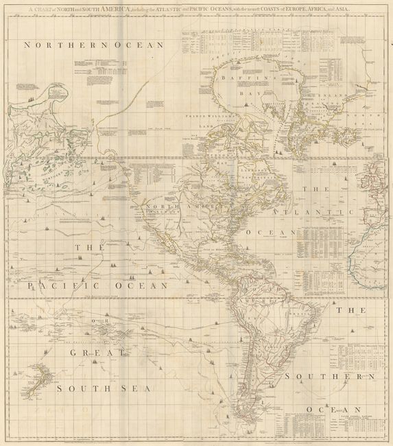
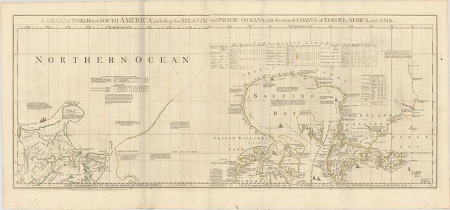
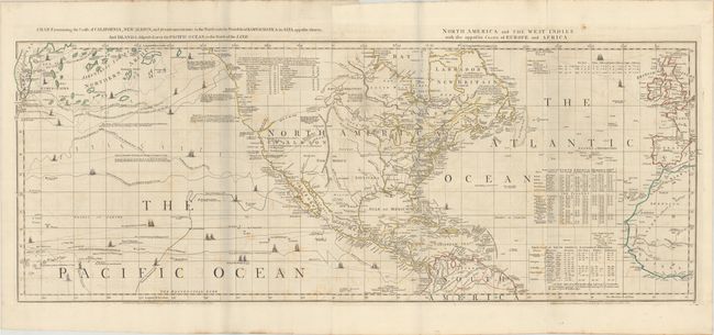
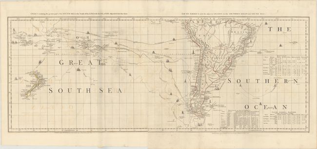
Subject: Western Hemisphere - America

Period: 1775 (dated)

Publication: The American Atlas

Color: Hand Color

Size:
44 x 18 inches
111.8 x 45.7 cm
Download High Resolution Image
(or just click on image to launch the Zoom viewer)

Thomas Jefferys was one of the most important English map publishers of the 18th century. His work included prints and maps of locations around the world, but his most notable maps are of North America and the West Indies. He began his career in the map trade in the early 1730s, working as an engraver for a variety of London publishers, and eventually setting up his own shop. In 1746, he was appointed Geographer to the Prince of Wales, and in 1760 he became Geographer to the King. These titles granted access to manuscripts and cartographic information held by the government. In the early 1760s he embarked on an ambitious project to produce a series of English county maps based on new surveys, but ran out of money and filed for bankruptcy in 1766. He then partnered with London publisher Robert Sayer, who reissued many of Jefferys plates and continued to issue new editions after Jefferys' death in 1771. Jefferys' American Atlas and the accompanying West-India Atlas, published post posthumously, are considered his most important cartographic works.

This important American map was compiled in 1753 by Braddock Meade, one of the most intriguing figures in British cartographic history as well as an extremely gifted mapmaker. Working under the alias John Green after serving time for defrauding an Irish heiress, he compiled many of Thomas Jefferys' most important maps. It was partly designed to expose the errors in Delisle and Buache’s map of the Pacific Northwest. It was the first map to label Behring's Straits and includes a plethora of information on explorers and their discoveries. Of particular interest are the tables of charts that show the variations in latitude and longitude between this chart and those of Bellin, D'Anville, Moll, and Senex. There are numerous notations throughout the map that present a fascinating view of the state of geographic knowledge of the period. Several indignant notes on the Pacific Northwest include, "These parts, as yet wholly unknown are filled up, by Messrs Buache and Delisle with the pretended discoveries of Adm. de Fonte and his Captains in 1640." It also includes numerous notations concerning Russian explorations and presents a bulbous shaped Peninsula of the Tchuktschi whose Extent and Dimensions are unknown…. This final edition includes a number of updates not present in the earlier editions, including the track of Lt. Sindo in 1764-67 and revisions in the Anadirskiai Islands where Alaska appears as a large island labeled Alaschka. Six sheets divided into three joined horizontal pairs.

Jefferys was the leading English cartographer of the 18th century, serving as both Geographer to the Prince of Wales, and later, Geographer to the King, he had access to the best surveys conducted in America. He published a series of maps of the American colonies that were among the most significant produced in the period, including the Fry/Jefferson map of Virginia, Braddock Meade’s map of New England, and William Scull’s map of Pennsylvania and the western frontier. His successors, Sayer and Bennett, gathered these separately-issued maps together and republished them as The American Atlas. "It was, very likely, consulted by American, English, and French civilian administrators and military officers during the Revolution." (Ristow)

References: Ristow pp. 31-32; Schwartz & Erhrenberg, p.158-59; Stevens & Tree #4-Sheet III & IV (d); Wagner (NW) #578 & p. 160 (1st ed.).

Condition: B+

Issued folding on sturdy sheets with the watermarks of the Strasbourg Lily and the initials "WF." There is light soiling and offsetting. There are grayish shadows that are caused by our scanner and do not appear on the maps themselves. The first image is a composite image - the maps are joined in three horizontal pairs.

Estimate: $3,000 - $4,000

Sold for: $2,200

Closed on 9/14/2022

Archived